Fallison Lake Nature Trail Photos


You might also consider
More like Fallison Lake Nature Trail
Recommended Reviews - Fallison Lake Nature Trail
Start your review...

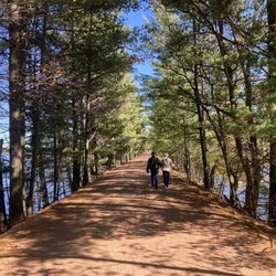
My girlfriend and I enjoy visiting beautiful parts of the country and going on day hikes. Even when these hikes are only a couple miles long, I panic and begin to despair towards the back half. So it's important that we find the right mix of natural beauty and for my sanity's sake, brevity. Fallison Lake Nature Trail is a 2.5-mile loop trail rolls through rich birding terrain. The lake is surrounded by a mixed coniferous/deciduous forest of balsam fir, hemlock, red pine, white pine, sugar maple, white birch, and large-toothed and trembling aspen. The trail crosses bogs and a hemlock glade. Some of these ancient giants of the Northwoods are hundreds of years old. The longest loop of the trail goes all the way around 50-acre Fallison Lake: we took a shortcut and skipped the final bog to cut down on my whining! read more


More info about Fallison Lake Nature Trail
County Rd N
Sayner, WI 54560
Directions
Hours
Outdoor Amenities


Fallison Lake Nature Trail - hiking - Updated July 2026
Best of Sayner
People found Fallison Lake Nature Trail by searching for…
Trending Searches in Sayner, WI
Browse Articles
Browse Nearby
Browse Brands
Related Searches in Sayner, WI
Best Fishing Locations and Guides in Sayner, Wisconsin
Best Nature Trails for Hiking in Sayner, Wisconsin
Best Places for Horseback Riding in Sayner, Wisconsin
Best Places for Stunning Views in Sayner, Wisconsin
Best Spots for Star Gazing in Sayner, Wisconsin
Best Waterfalls and Swimming Holes in Sayner, Wisconsin
Discover Popular Bike Trails in Sayner, Wisconsin
Discover Scenic Creeks to Explore in Sayner, Wisconsin
Discover Top Nature Parks to Visit in Sayner, Wisconsin
Discover a Hiking Trail in Sayner, Wisconsin
Enjoy Camping Adventures Around Sayner, Wisconsin
Enjoy Exciting Mountain Biking Adventures in Sayner, Wisconsin
Enjoy the Best Night View Spots in Sayner, Wisconsin
Enjoy the Best Picnic Spots and Ideas in Sayner, Wisconsin
Experience Stunning Sunset Views in Sayner, Wisconsin
Explore Beautiful Parks and Green Spaces in Sayner, Wisconsin
Explore Free Things to Do Around Sayner, Wisconsin
Explore Popular Boat Charters Near Sayner, Wisconsin
Explore Popular Campgrounds Near Sayner, Wisconsin
Explore Popular View Points Around Sayner, Wisconsin
Family Friendly Hiking With Kids in Sayner, Wisconsin
Find Beautiful Views in Sayner, Wisconsin
Find Cozy Camping Cabins in Sayner, Wisconsin
Find Fun Kids Activities Outdoor in Sayner, Wisconsin
Find Picnic Tables for Outdoor Fun in Sayner, Wisconsin
Find the Best Playgrounds to Visit in Sayner, Wisconsin
Find the Best Scenic View Locations in Sayner, Wisconsin
Locate a Public Shower Facility in Sayner, Wisconsin
Must-See Tourist Attractions Around Sayner, Wisconsin
Perfect Spots to Watch Sunset in Sayner, Wisconsin
Plan Nature Center Visits in Sayner, Wisconsin
Popular Fishing Spots to Explore in Sayner, Wisconsin
Popular Places to Take Pictures in Sayner, Wisconsin
Popular Things to Do in Sayner, Wisconsin
Relax at Natural Hot Springs Near Sayner, Wisconsin
Safe River Swimming Areas in Sayner, Wisconsin
Safe and Fun Parks for Kids in Sayner, Wisconsin
Top Playgrounds for Kids to Enjoy in Sayner, Wisconsin