Public Recreation Area 19 Photos


More like Public Recreation Area 19
Recommended Reviews - Public Recreation Area 19
Start your review...

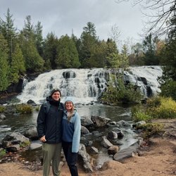
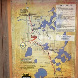
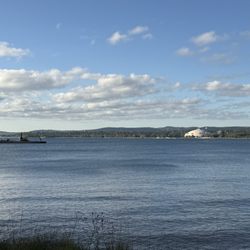
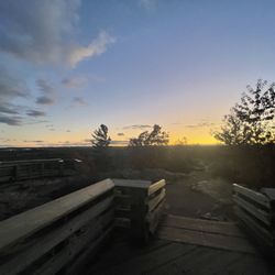
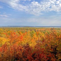
This is a good way to use Yelp for my own sake... OK, this place is not a must-see tourist attraction in Upper Michigan but it has a special attraction - driftwood. If you like driftwood for decorative purposes, here's the place! Seems lots of North Woods cabins have some driftwood in their yards, or people craft things using driftwood. Here's a great beach for finding it. The place is about 8 miles off the major highway and is hard to get to. If anything, by writing this review, it will help me remember how to find it next time. Going northbound from downtown Crystal Falls along US-141, turn right at Fisher Road. These are all gravel backroads from here on. Continue on Fisher, then turn left on Balsam Road. Once you get to WPA Road, you'll see a sign for Recreation Areas 17 & 19. Turn right and continue towards Area 19. There will be some twist and turns but keep going. You'll see a lake and a boat landing area. The actual driftwood beach is a little walk down a hiking path. The beach is lined with wooden stairs to sit and watch the water. Off to the side is a wooded area with all kinds of driftwood washed ashore. Some are dog-fetching stick size and others are 12-footers that would require two people to carry them out of the water. The lake is part of the Way Dam hydroelectric project, so water levels can vary. Happy hunting! read more


More info about Public Recreation Area 19
Wpa Road At Way Dam
Crystal Falls, MI 49920
Directions
Hours
Outdoor Amenities


Public Recreation Area 19 - hiking - Updated May 2026
Best of Crystal Falls
Browse Brands
Related Searches in Crystal Falls, MI
Affordable Fishing Rental Services in Crystal Falls, Michigan
Best Fishing Locations and Guides in Crystal Falls, Michigan
Best Nature Trails for Hiking in Crystal Falls, Michigan
Best Places for Stunning Views in Crystal Falls, Michigan
Best Pontoon Boat Rentals Near Crystal Falls, Michigan
Best Spots for Star Gazing in Crystal Falls, Michigan
Best Waterfalls and Swimming Holes in Crystal Falls, Michigan
Boat Parts & Supplies Near Crystal Falls, Michigan
Discover Popular Photo Spots in Crystal Falls, Michigan
Discover Romantic Activities to Enjoy in Crystal Falls, Michigan
Discover Scenic Creeks to Explore in Crystal Falls, Michigan
Discover Top Nature Parks to Visit in Crystal Falls, Michigan
Discover a Hiking Trail in Crystal Falls, Michigan
Discover the Best Beaches in Crystal Falls, Michigan
Discover the Best Night Hike Trails in Crystal Falls, Michigan
Enjoy Hiking Adventures in Crystal Falls, Michigan
Enjoy Tent Camping Spots Around Crystal Falls, Michigan
Enjoy the Best Picnic Spots and Ideas in Crystal Falls, Michigan
Enjoy the Best Tubing Experiences in Crystal Falls, Michigan
Enjoy the Best Walking Trails in Crystal Falls, Michigan
Explore Beautiful Parks and Green Spaces in Crystal Falls, Michigan
Explore Easy Hikes Perfect for All in Crystal Falls, Michigan
Explore Marine Services and Options in Crystal Falls, Michigan
Explore Nature Spots Around Crystal Falls, Michigan
Explore Parks With Lakes to Visit in Crystal Falls, Michigan
Explore Popular RV Parks Around Crystal Falls, Michigan
Explore Scenic Lakes to Visit in Crystal Falls, Michigan
Explore the Best Bait Shops Around Crystal Falls, Michigan
Explore the Best Boating Spots in Crystal Falls, Michigan
Family Friendly Hiking With Kids in Crystal Falls, Michigan
Find Beautiful Views in Crystal Falls, Michigan
Find Cozy Camping Cabins in Crystal Falls, Michigan
Find Fun Kids Activities Outdoor in Crystal Falls, Michigan
Find Picnic Tables for Outdoor Fun in Crystal Falls, Michigan
Find Top-Rated Waterfalls in Crystal Falls, Michigan Now
Find Trusted Boat Dealers in Crystal Falls, Michigan Today
Find the Best Parks for Picnics in Crystal Falls, Michigan
Find the Best Playgrounds to Visit in Crystal Falls, Michigan
Find the Best Scenic View Locations in Crystal Falls, Michigan
Great Places to Swim in Crystal Falls, Michigan
Locate a Public Shower Facility in Crystal Falls, Michigan
Must-See Tourist Attractions Around Crystal Falls, Michigan
Plan Nature Center Visits in Crystal Falls, Michigan
Popular Fishing Spots to Explore in Crystal Falls, Michigan
Popular Things to Do in Crystal Falls, Michigan
Relax at Natural Hot Springs Near Crystal Falls, Michigan
Reliable Outboard Motor Repair in Crystal Falls, Michigan
Safe River Swimming Areas in Crystal Falls, Michigan
People found Public Recreation Area 19 by searching for…
Boat Rental in Crystal Falls, MI
Hiking Trails in Crystal Falls, MI
Swimming Lakes in Crystal Falls, MI
Waterfalls in Crystal Falls, MI
Things to Do in Crystal Falls, MI
Tourist Attractions in Crystal Falls, MI
Places to Swim in Crystal Falls, MI
Scenic Drive in Crystal Falls, MI
Walking Trails in Crystal Falls, MI
Dog Friendly Trails in Crystal Falls, MI
Swimming Holes in Crystal Falls, MI
Boat Launch in Crystal Falls, MI
Fishing Spots in Crystal Falls, MI
Off Road Trails in Crystal Falls, MI
Things to See in Crystal Falls, MI
Boat Ride in Crystal Falls, MI
Sightseeing in Crystal Falls, MI
Lakes & Ponds in Crystal Falls, MI
Attraction in Crystal Falls, MI
Canoe Rental in Crystal Falls, MI
Trending Searches in Crystal Falls, MI
Boating near Public Recreation Area 19
Fishing near Public Recreation Area 19
Hair Stylists near Public Recreation Area 19
Hiking near Public Recreation Area 19
Nurseries & Gardening near Public Recreation Area 19
Parks near Public Recreation Area 19
Playgrounds near Public Recreation Area 19