Lookout Trail Photos


You might also consider
More like Lookout Trail
Recommended Reviews - Lookout Trail
Start your review...

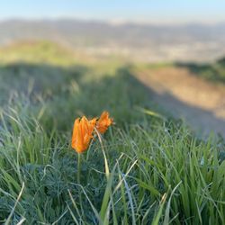
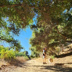
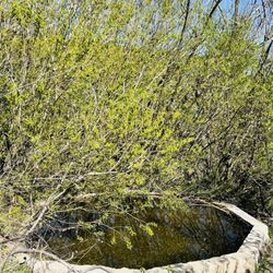
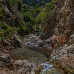
Reviews With Photos

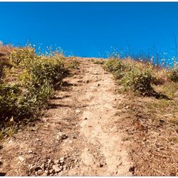
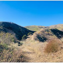
It's a short, decent trail with pretty good views. Route: The southern access is directly to the right of the entrance bridge right on the O'Melveny Park parking lot. From here there's a moderately difficult incline for about 500 feet, after which there's a relatively flat trail on a ridgeline, giving surprisingly good views of the park and the Santa Susana sierra to the west and to the south and east you get a pretty good view of Granada Hills and the rest of the valley on a day with good weather. This flat ridgeline trail goes on for about 440 feet, after which there's a moderate, but not very challenging decline for about 70 feet up to the Loop Trail. This last decline has a few wood steps to help hikers. Trail description: The incline and decline parts of the trail were very overgrown when I went in June. Lots of tall mustard blocks your way and you have to swat it away from you. There's also quite a bit of thistles which thankfully only tend to grow up to waist length, but they do grow into the trail so it's almost impossible to not get stung through your pants, so be sure to wear something thicker after the rains. There are two points in the flat ridge where the trail lets out to small bare dirt areas that can be a good place to take quick breaks. Overall it's a short trail which can be challenging depending on the season and where you start and has a quick and satisfying payoff with the views.

7 months ago
Never heard of such trail exist, recently I tried it first time and it's just wow! If you're looking for the great workout with a view! read more


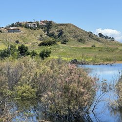
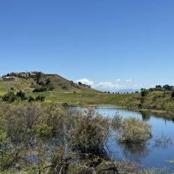
There is no shade on this trail which was perfect on this cold New Year's Day. It was certainly a workout, but most certainly doable. We had a toddler with us and he made it all the way up and then down. There are shortcuts but I don't recommend taking the shortcuts unless you want to up your workout even more. There is a bench under a giant tree close to the top as a reward. I would say the view from the top is a reward, but really, you can enjoy the awesome view from the trail even without making it all the way to the top. At the very top, there is a memorial... behind it, you'll see the a giant pit where Sunshine Canyon is or used to be... feel free to let me know if I got that bit wrong or not. That giant pit that looked like a mini-city with those roads and vehicles moving about was very interesting... maybe it's SoCal Gas is getting their natural gas from? read more


3 years ago
It's a short, decent trail with pretty good views. Route: The southern access is directly to the right of the entrance bridge right on the O'Melveny Park parking lot. From here there's a moderately difficult incline for about 500 feet, after which there's a relatively flat trail on a ridgeline, giving surprisingly good views of the park and the Santa Susana sierra to the west and to the south and east you get a pretty good view of Granada Hills and the rest of the valley on a day with good weather. This flat ridgeline trail goes on for about 440 feet, after which there's a moderate, but not very challenging decline for about 70 feet up to the Loop Trail. This last decline has a few wood steps to help hikers. Trail description: The incline and decline parts of the trail were very overgrown when I went in June. Lots of tall mustard blocks your way and you have to swat it away from you. There's also quite a bit of thistles which thankfully only tend to grow up to waist length, but they do grow into the trail so it's almost impossible to not get stung through your pants, so be sure to wear something thicker after the rains. There are two points in the flat ridge where the trail lets out to small bare dirt areas that can be a good place to take quick breaks. Overall it's a short trail which can be challenging depending on the season and where you start and has a quick and satisfying payoff with the views. read more


The Lookout Trail is located within O'Melveny Park. The trail can either start near the entrance or start from within the park which you can come across while walking the Picnic Trail. Starting by the entrance can be hard since it isn't as well paved, isn't as noticeable or marked, and has a decent incline. I recommend starting off with The Picnic Trail and looking out for signs for The Loop Trail and The Lookout Trail which are pretty obvious. The Lookout Trail is fairly short and isn't too hard. Even though the trail is short the view isn't that bad given that you didn't have to travel far to see it. Overall One of the easier trails at O'Melveny Park but still a nice treat because it allows you to venture off into others. read more


More info about Lookout Trail
You might also consider


Lookout Trail - hiking - Updated May 2026
Best of Granada Hills
People found Lookout Trail by searching for…
Hiking Trails in Granada Hills, CA
Beautiful Views in Granada Hills, CA
Off Road Trails in Granada Hills, CA
Walking Trails in Granada Hills, CA
Lookout Points in Granada Hills, CA
Scenic Overlook in Granada Hills, CA
View Points in Granada Hills, CA
Easy Hikes in Granada Hills, CA
Free Campgrounds in Granada Hills, CA
Swimming Lakes in Granada Hills, CA
Stairs Workout in Granada Hills, CA
Shaded Hike in Granada Hills, CA
Scenic View in Granada Hills, CA
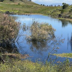
Lakes & Ponds in Granada Hills, CA
Parks for Kids in Granada Hills, CA
Running Trails in Granada Hills, CA
Picnic Areas in Granada Hills, CA
Nature Parks in Granada Hills, CA
Browse Nearby
BEST of Granada Hills, California Coffee near Lookout Trail
BEST of Granada Hills, California Restaurants near Lookout Trail
BEST of Granada Hills, California Things to Do near Lookout Trail
BEST of Granada Hills, California Breakfast near Lookout Trail
BEST of Granada Hills, California Walking Trails near Lookout Trail
BEST of Granada Hills, California Parks near Lookout Trail
BEST of Granada Hills, California Hotels near Lookout Trail
BEST of Granada Hills, California Campgrounds near Lookout Trail
Browse Brands
Browse Articles
People who viewed Lookout Trail also viewed
The Loop Trail
4 reviews
Granada Hills
Wilson Canyon Park
25 reviews
Sylmar
Mario DeCampos Trail
46 reviews
Granada Hills
Veterans Park Trail
1 review
Nature Trail
4 reviews
Granada Hills
Palisades Park
9 reviews
Porter Ranch
OAK SPRINGS
2 reviews
Sylmar
Browns Canyon Loop
1 review
Chatsworth
Colby Canyon Trail
3 reviews
Lopez Canyon Park
4 reviews