Wilson Canyon Park Photos


You might also consider
More like Wilson Canyon Park
Recommended Reviews - Wilson Canyon Park
Start your review...

Reviews With Photos

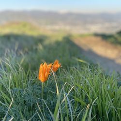
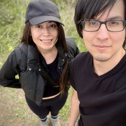
I can't believe I just discovered this beautiful-amazing-treasure spot in Sylmar, just 7 min. away from my house. Wilson Canyon Park is such a beautiful hiking spot. We parked on Olive View Drive...yes! It's right next to "Olive View Hospital". Even though there is parking spots on the top of the road...I really recommend for you to park in the street, that way you have a little "pre-workout walk" before you get to the actual hike & dirt road. I have taken like 3 different trails, one of them on the right side, is a straight road & you are just going up hill...it's so beautiful, so green, lots of flowers (I took a lot of pics, so you get an idea)... this road is a "Stairway to Heaven" when you get to the top...you will have a beautiful view of The Valley & there are 2 benches to rest. It's perfect. On my way back somewhere in between I took a left & I kept hiking through this little narrow trail...in between the mountains, the dirt looks like beach sand...I kept going down...& really feels like you are in the woods...you can hear water running...it gets a little dark, because there are so many trees & you literally get no phone service...you can only hear the sounds of the birds...beautiful but kinda scary at the same time... I really recommend for you to do this trail ONLY if you are with someone else...I've been there twice & it's always LONELY...I kinda felt like a strange vibe in a certain spot there...& my sister did too...so we are planing on making a "Treasure Box" or like paint some rocks & put them under a tree for good vibes. This place has become my favorite hiking place...but like I mentioned, unlike other hiking places this one is lonely...I've been there in the morning and afternoon...but I hardly ever see anyone on the trails. There are more people at the beginning of the trails, like in the actual road...since there is a nice view there too. I've seen people in their horses, which I find so beautiful. There is also a picnic area...& I read that there is an abandoned miniature Golf Course...but I haven't seen that one yet...I'll find it! & I also want to discover more trails! I recommend this hike a lot! It's Beautiful, relaxing...it's a little trip to the woods...don't forget to bring lots of water & company :) enjoy! From: City of Sylmar, with Love!

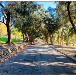
There are two different ways to start this trail. You can park your car along sketchy Olive View Dr., just east of the hospital, and then walk up a long paved road 0.4 miles until you reach the base of the mountain where there will be a green gate marking the start of the trail. The other starting point is through the official trailhead entrance. In order to avoid the $5 parking fee, you can park in the hospital parking lot and then walk up the road adjacent to the east side of the hospital. If you go this way then be sure to check out the semi-interesting abandoned mini golf course. The trail takes you 2 miles up the south side of the San Gabriel mountains. It's a fairly steady incline the first half of the way. The last half involves hiking up a steep and semi-slippery narrow path. It would be okay if there were a big payoff at the end, like a plaque or bench, but in the end all you're rewarded with is a crummy ole dead tree and some spiky plants poking your legs. You also get a great panoramic view of the San Fernando Valley topped with a nice brown layer of smog. It may not be on any top 10 lists of best hikes, but it will definitely give your thighs and calves a good work-out. On your way back down you can go down an opposite entrance from which you came to change it up a bit. I lost 2 pounds worth of water weight because I went on a really hot day so be sure to pack enough H2O.

Started near Olive View Hospital and hiked all the way to the top to Los Pinetos. The hike starts a bit strenuous but becomes easier after you pass the electrical towers. Went on a really windy day and was not prepared to turn into a popsicle but this hike was totally worth it! The view was breathtaking and pictures can't do it justice. Make sure to bring snacks and water, wear proper foot wear, and bring extra clothes/accessories just in case it gets cold. There were signs warning us of snakes, and other hikers warned us of coyotes and mountain lions (so maybe bring a friend?). Also, try to go early since the sun sets around 4pm nowadays.

Not a bad trail especially when considering how close it is to the valley. Wilson Canyon Park is literally right next to Olive View Hospital. There is street parking or lot parking which cost $5 and is enforced through the honor system. I've been to this park twice and the first time we parked inside which was a bit confusing because it isn't clear where to exactly park but you do save yourself the trouble of hiking up the paved road. Then, the second time we went we parked on the street. At first we only found one trail but it did seem to venture off into others. The trails aren't too shaded so I wouldn't recommend going on a hot day, the trails have nice views if you manage to get high enough, and it also seems like the trails are used to walk horses because there was quite a bit of poop on it. Overall Not a bad little hike if you're looking to stay close to home. I'll definitely be back to explore a little more, lets hope I find something a bit more appealing to it.


Good inclines. Nice scenery. I do wish the trail was longer. This is one of those trails that you can jog, if you are up for that. The trail itself is wide. There are a few places that would make for good photos ops. Of course my phone died rendering me unable to take more than a couple. Rule number one: before you set out on a hike make sure your phone is charged. Easy to locate and parking is ample. Perfect place for a morning hike to get the blood pumping. I assume if you want to make it a longer hike you could go off trail. I personally am a bit too fearful to attempt that.


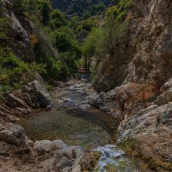
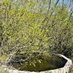
This park offers a plethora of hiking trails, picnic tables in an oak grove, and a large parking lot. There is a $5 parking fee requested; but it seems like most folks, including me, park on the street for free and hike up to the trailhead. This will add about a mile to your workout (round-trip), but that's good, right? I completed the loop trail this time (trail map here https://trails.lacounty.gov/Trail/1833/wilson-canyon-loop-trail ) and really enjoyed it. There is a pretty significant altitude gain, so be prepared. The trail had definitely been affected by recent rains, with a lot of ruts in the road, but nothing impassable. You'll start out in chaparral, then go up through an oak/sycamore grove near an intermittent stream, and than descend on the north side back to the trailhead. There's also a year-round stream to the north of the hiking area; not sure if it's technically part of the park but it's worth seeking out. Hiking boots with good tread, hiking poles, and water are recommended. Hat, sunscreen and shades on sunny days. And don't forget snacks and a charged phone. Highly recommended. read more


Your mindset is what separates you from the rest. Let's begin this new trail adventure. WILSON CANYON PARK is a 2.8-mile loop trail at Sylmar, California. This trail is quite popular for horseback riding, hiking, and birding. It has an elevation gain of 705 ft.; trails were well maintained, however, there were sections of the Saddle Ranch trailhead that you go through a very narrow trench-just past the water dam structure- which doesn't look like a trail but it is part of the trailhead. You start with a very sandy trail and progresses to a rocky and then smoothed out as you ever to higher elevation. This trail has rich in flora and fauna, wild animals and insects. I saw a juvenile snake (not sure if it's a Sierra Garter snake) as I descend back. YIKES! I decided to hit the Pig Ranch trail as well. Both trails deemed Easy for experienced hikers. Fellow hikers were cordial and respectful. I even saw a male hiker, wearing plaid shirt and jeans, brought his 4 lil boys on the trail. Great family bonding. Anyways, this was a nice hike with great scenery even on a slightly foggy day. Parking has a $5 honor system as you drive inside the park. Overall, WCT is a good quick hike and I recommend it. read more


Quick, semi intense, great incline with an amazing view of the valley! Several different trail options which is awesome. One of my favorite go to hikes to get a quick 1hr burn in and take in some amazing views of the entire valley. On a crisp clear day you can see all the way over to warner center. PARKING: Parking is free on the street, along the entrance to the fire paved road. At the bottom of Olive View Hospital. This is where you start and hike up the fire paved road which is a steady and great incline! If you want to drive up the paved road, you pay $5 at the bottom using the honor system and you start the hike from the top of the paved road. Stay to the right. HIKE: You can walk the paved road, and stop at the top of it if you would like just an easy incline, or you can ramp it up, veer to the right at the top of the paved road and on your left you'll see the dirt entrance to start the hike up. About an hour-hour and 15mins from the bottom of the fire road to the top and down. Gorgeous views the whole way, and at the top is a flat overlook with 2 benches. Easy-Moderate not suitable for wheelchairs or strollers. Not so difficult you cant strap a baby to your back or chest and handle business! Good for dogs on the leash, but be careful in the summer there are rattlesnakes (I've encountered a few) I love this hike and it really let's you take in our beautiful San Fernando Valley! read more


I can't believe I just discovered this beautiful-amazing-treasure spot in Sylmar, just 7 min. away from my house. Wilson Canyon Park is such a beautiful hiking spot. We parked on Olive View Drive...yes! It's right next to "Olive View Hospital". Even though there is parking spots on the top of the road...I really recommend for you to park in the street, that way you have a little "pre-workout walk" before you get to the actual hike & dirt road. I have taken like 3 different trails, one of them on the right side, is a straight road & you are just going up hill...it's so beautiful, so green, lots of flowers (I took a lot of pics, so you get an idea)... this road is a "Stairway to Heaven" when you get to the top...you will have a beautiful view of The Valley & there are 2 benches to rest. It's perfect. On my way back somewhere in between I took a left & I kept hiking through this little narrow trail...in between the mountains, the dirt looks like beach sand...I kept going down...& really feels like you are in the woods...you can hear water running...it gets a little dark, because there are so many trees & you literally get no phone service...you can only hear the sounds of the birds...beautiful but kinda scary at the same time... I really recommend for you to do this trail ONLY if you are with someone else...I've been there twice & it's always LONELY...I kinda felt like a strange vibe in a certain spot there...& my sister did too...so we are planing on making a "Treasure Box" or like paint some rocks & put them under a tree for good vibes. This place has become my favorite hiking place...but like I mentioned, unlike other hiking places this one is lonely...I've been there in the morning and afternoon...but I hardly ever see anyone on the trails. There are more people at the beginning of the trails, like in the actual road...since there is a nice view there too. I've seen people in their horses, which I find so beautiful. There is also a picnic area...& I read that there is an abandoned miniature Golf Course...but I haven't seen that one yet...I'll find it! & I also want to discover more trails! I recommend this hike a lot! It's Beautiful, relaxing...it's a little trip to the woods...don't forget to bring lots of water & company :) enjoy! From: City of Sylmar, with Love! read more


 - Hiking Near Me - Sylmar, California")


3 years ago
There are two different ways to start this trail. You can park your car along sketchy Olive View Dr., just east of the hospital, and then walk up a long paved road 0.4 miles until you reach the base of the mountain where there will be a green gate marking the start of the trail. The other starting point is through the official trailhead entrance. In order to avoid the $5 parking fee, you can park in the hospital parking lot and then walk up the road adjacent to the east side of the hospital. If you go this way then be sure to check out the semi-interesting abandoned mini golf course. The trail takes you 2 miles up the south side of the San Gabriel mountains. It's a fairly steady incline the first half of the way. The last half involves hiking up a steep and semi-slippery narrow path. It would be okay if there were a big payoff at the end, like a plaque or bench, but in the end all you're rewarded with is a crummy ole dead tree and some spiky plants poking your legs. You also get a great panoramic view of the San Fernando Valley topped with a nice brown layer of smog. It may not be on any top 10 lists of best hikes, but it will definitely give your thighs and calves a good work-out. On your way back down you can go down an opposite entrance from which you came to change it up a bit. I lost 2 pounds worth of water weight because I went on a really hot day so be sure to pack enough H2O. read more


7 years ago
Started near Olive View Hospital and hiked all the way to the top to Los Pinetos. The hike starts a bit strenuous but becomes easier after you pass the electrical towers. Went on a really windy day and was not prepared to turn into a popsicle but this hike was totally worth it! The view was breathtaking and pictures can't do it justice. Make sure to bring snacks and water, wear proper foot wear, and bring extra clothes/accessories just in case it gets cold. There were signs warning us of snakes, and other hikers warned us of coyotes and mountain lions (so maybe bring a friend?). Also, try to go early since the sun sets around 4pm nowadays. read more


Not a bad trail especially when considering how close it is to the valley. Wilson Canyon Park is literally right next to Olive View Hospital. There is street parking or lot parking which cost $5 and is enforced through the honor system. I've been to this park twice and the first time we parked inside which was a bit confusing because it isn't clear where to exactly park but you do save yourself the trouble of hiking up the paved road. Then, the second time we went we parked on the street. At first we only found one trail but it did seem to venture off into others. The trails aren't too shaded so I wouldn't recommend going on a hot day, the trails have nice views if you manage to get high enough, and it also seems like the trails are used to walk horses because there was quite a bit of poop on it. Overall Not a bad little hike if you're looking to stay close to home. I'll definitely be back to explore a little more, lets hope I find something a bit more appealing to it. read more


12 years ago
15 years ago
This is a beautiful place to take a stroll any day of the week. Wear pants as trails aren't very groomed. The trees, creeks and flora will keep you smiling. Bring your dogs, a packed lunch and a camera and you'll be sure to have a great time. read more


13 years ago
16 years ago


12 years ago
Good inclines. Nice scenery. I do wish the trail was longer. This is one of those trails that you can jog, if you are up for that. The trail itself is wide. There are a few places that would make for good photos ops. Of course my phone died rendering me unable to take more than a couple. Rule number one: before you set out on a hike make sure your phone is charged. Easy to locate and parking is ample. Perfect place for a morning hike to get the blood pumping. I assume if you want to make it a longer hike you could go off trail. I personally am a bit too fearful to attempt that. read more

13 years ago
10 years ago
Amazing hike went up 4.5 miles close to towers... so many different trails break off at 4 mile mark read more


15 years ago
I love this place i come here maybe # times a week! its a great place for a picnic! or romantic date up by the waterfalls! luv it! read more


15 years ago
13 years ago
14 years ago
Just went up there on Thursday March 22, 2012. The water level was O.K. took some new photo's too! read more


13 years ago
14 years ago
More info about Wilson Canyon Park
Ask the Community - Wilson Canyon Park
Review Highlights - Wilson Canyon Park
You might also consider


Wilson Canyon Park - hiking - Updated May 2026
Best of Sylmar
People found Wilson Canyon Park by searching for…
Beautiful Views in Sylmar, California
Hiking Trails With Waterfalls in Sylmar, California
Places to Take Pictures in Sylmar, California
Off Road Trails in Sylmar, California
Running Trails in Sylmar, California
Flower Fields in Sylmar, California
Walking Trails in Sylmar, California
Scenic View in Sylmar, California
Romantic Views in Sylmar, California
Photo Spots in Sylmar, California
Easy Hikes in Sylmar, California
Scenic Overlook in Sylmar, California
View Points in Sylmar, California
Natural Hot Springs in Sylmar, California
Things to Do in Sylmar, California
Sand Dunes in Sylmar, California
Picnic Areas in Sylmar, California
Tourist Attractions in Sylmar, California
Browse Nearby
BEST of Sylmar, California Coffee near Wilson Canyon Park
BEST of Sylmar, California Restaurants near Wilson Canyon Park
BEST of Sylmar, California Things to Do near Wilson Canyon Park
BEST of Sylmar, California Parks near Wilson Canyon Park
BEST of Sylmar, California Breakfast near Wilson Canyon Park
Browse Brands
Browse Articles
People who viewed Wilson Canyon Park also viewed
Veterans Memorial Park
102 reviews
Aliso Canyon Park
80 reviews
Granada Hills
Lookout Trail
5 reviews
Granada Hills
Limekiln Canyon Trail
74 reviews
Porter Ranch
Veterans Park Trail
1 review
East Walker Ranch
5 reviews
Rocky Peak Park
62 reviews
Wildwood Canyon Open Space
3 reviews
OAK SPRINGS
2 reviews
Sylmar
Pico Canyon Park
21 reviews