Mario DeCampos Trail Photos


You might also consider
More like Mario DeCampos Trail
Recommended Reviews - Mario DeCampos Trail
Start your review...

Reviews With Photos


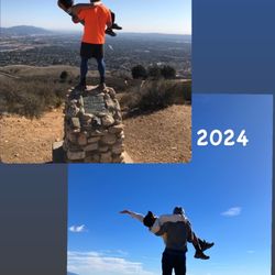
We wouldn't call this an easy hike but it's also not difficult and not little kid friendly. We brought our 4 year old Golden Doodle with us and he definitely was starting to slow down about a 1.5 miles in, so use your better judgment when bringing your dog. You definitely need water, a hat and sunscreen as there is no shade until the two oak trees, about a 1.5 miles up the trail and it gets warm fast. The peak was a bit windy but definitely not cold as it was 72°. We would consider ourselves fit and active and we did break a sweat. 3.6 miles round trip, 1.5 hours with a rest at the oak trees and the peak. The entire hike up is an incline on a trail that consists of loose gravel with some rocks and a lot of storm damage. The trail does have many holes that average about 2.5' deep and you can easily fall inside, so watch your step. We didn't see much wildlife other than some lizards and birds. Parking was easy mid morning and at the end of a cul de sac in a nice neighborhood not too far off the 118 freeway. There are no restrooms or drinking fountains at this location. The reviews of this hike can be discouraging as it's made out to be difficult, don't let it stop you. It's a great work out and if you don't make it to the top, turn around and try again another time, it's not worth the risk of passing out. The last two big inclines are a challenge if you're not used to hiking. Once you see the two big oak trees on top of the hill you are almost there. Follow the fence along the gas lines for a direct route to the oak trees. There you will find a nice bench to stop, catch your breath, have a snack and to enjoy the view. To the kind soul who left a Mission Point sign at the peak, Thank You! , it was fun taking photos with it. We felt safe on this trail and I would even consider doing it solo if I had to, as it is a pretty direct hike even though it's not clearly marked. Enjoy!


This trail was a great find! Conditions when I hiked were post morning rainfall, early afternoon, partly cloudy and gradually windy and cool as you reached the top. Might have been because it rained earlier in the day but there were hardly any people on the trail, which made it a bit more enjoyable. The rain of course did make for some muddy spots but nothing to dramatic. The views on the way up were amazing and the top once breathe-taking. Total hike took me about 2.5 hours with various breaks to take pictures and explore.

This hike wasn't too bad. It took us about 30 minutes to get all the way to the top. There is a nice tree to hang out under once you are done. We started at 9am. There was a nice breeze at the top. Notes: There are rattlesnakes out at least from what we heard going up.. Dont wonder directly into the high weeds. Parking in the neighborhoods. Difficulty of hike: 7 Verdict: Bring some water, you are not going to die.


Looking for secluded trail that is off the beaten path, try Mario DeCampos Trail on Sulphur Spring Fire Road in Granada Hills. Great trails to get your workout done or to de-stress. Regardless of fitness level this place can still woop your behind. Low to medium slope. Below is a summary of my endeavor- Sat, Sept 2 Walk, Jog... Run 8:05 AM - 9:37 AM Active Calories: 373 CAL Total Calories: 494 CAL Distance: 3.83 MI Elevation Gain: 1,023FT Total Time: 1:27:01 Avg. Heart Rate 136BPM Avg. Pace 22'41"/MI Weather 93deg Humidity: 27% Stunning views of the Valley... Bring your selfie stick and a willingness to explore! Entrance to the trail is at the end of a neighborhood, on a dead end street. (No parking lot).

I didn't think that the home would be steep or difficult, but if you haven't hiked in months make sure you are ready for it. Was definitely worth it, unfortunately the dryness and lack of rain didn't make much for a sight but the overlooking the valley ore is pretty cool. I recommend this ...

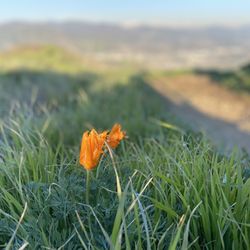
OHHHH this was a good one! I had planned on going to the O'Melvany Park trails, but the Yelp directions led me here. The entrance is at the end of a cul-de-sac right in the middle of a neighborhood, so plenty of street parking. It's a bit of a doozie getting up to the top. I'm not going to lie, I had to stop a few times along the trail. That was fine by me, the views are beautiful. There is no cover so I'd avoid this hike during the summertime. The people were all very friendly and it was clean. I will absolutely be coming back and tackling this trail again. Pretty wild flowers can be seen along the trail and I spotted a baby hummingbird.

My favorite trail in the valley! Plenty of parking, nice views, and friendly people. It's definitely a challenge even for people who exercise everyday, since it's mostly uphill from the very start, but the views are worth it once you get closer to the top! My only complaint would be the off-leash and aggressive dogs on this trail. I've brought both my dogs here and on several occasions there have been off-leash dogs who try to attack my dogs (who are always on their leash). But there are several friendly, well-trained off leash dogs who get along just fine with all the other people and animals on the trail.. it just sucks that I have to be very cautious due to irresponsible dog owners. Also, as far as the coyote issue, I have seen lots of coyotes on this trail but they run away at the sight of humans and dogs. I usually see them more often when the trail is fairly empty, like on a weekday morning.
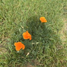
Amazing view of all the valleys and you can even see the buildings of downtown LA from a distance. Many different trails but we kept to this one. We didn't get to where the bench is but we stop in a nice calm hill. The flowers were blooming it kind of felt like the sound of music hills. Worth the hike


4 months ago
Soooooo many flowers. I loved it! There are not too many shaded areas on this hike so bring lots of water :). read more


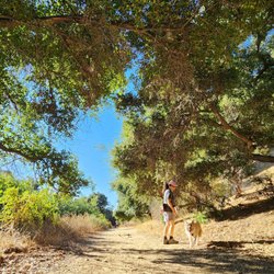
M. DeCampos trail is a very popular area for hiking, mountain biking, and running. This trail is located within the O'Melveny Park. This trail has an elevation gain of 1,227 ft has a length of 4.3 miles leading to Mission Point. Throughout the trail has no shades going toward the Mission Point. But you'll get to see birds, lizards and vole. I hiked on a weekday so there were very few hikers that I came across on the trailhead. Dogs are welcome, but must be on a leash. Once you've reached Mission Point which is considered the highest point in the SF valley you'll have a majestic view of the hills, the park and mountains. Overall, despite its steep trails I enjoyed my time hiking this trail. read more


Hiked this trail over the weekend - started from O'Melveny Park and went clockwise to the Bee Canyon Trail to Mission Peak then back via the Mario DeCampos Trail. It is def a pretty steep incline if you go counterclockwise and a slow gradual descent. If you prefer a slow incline and steep decline, definitely go clockwise. The views were amazing at the top as you can see the entire San Fernando Valley. Definitely wear hiking shoes/boots with good treads as there's a lot of loose pebbles throughout the trail. Majority of the hikers wore masks/put them up when passing other hikers. Bring water and a small snack. read more


6 years ago
Was catching my breathe already . Not much people and no dog poop. Clean and fresh air. If you go all the way to the top you will end up going towards the Top Of O'melveny. Nice hiking place to unwind. read more


5 years ago
Fun and challenging incline hike. Beautiful view of the San Fernando as your making your way to the top. read more


We wouldn't call this an easy hike but it's also not difficult and not little kid friendly. We brought our 4 year old Golden Doodle with us and he definitely was starting to slow down about a 1.5 miles in, so use your better judgment when bringing your dog. You definitely need water, a hat and sunscreen as there is no shade until the two oak trees, about a 1.5 miles up the trail and it gets warm fast. The peak was a bit windy but definitely not cold as it was 72°. We would consider ourselves fit and active and we did break a sweat. 3.6 miles round trip, 1.5 hours with a rest at the oak trees and the peak. The entire hike up is an incline on a trail that consists of loose gravel with some rocks and a lot of storm damage. The trail does have many holes that average about 2.5' deep and you can easily fall inside, so watch your step. We didn't see much wildlife other than some lizards and birds. Parking was easy mid morning and at the end of a cul de sac in a nice neighborhood not too far off the 118 freeway. There are no restrooms or drinking fountains at this location. The reviews of this hike can be discouraging as it's made out to be difficult, don't let it stop you. It's a great work out and if you don't make it to the top, turn around and try again another time, it's not worth the risk of passing out. The last two big inclines are a challenge if you're not used to hiking. Once you see the two big oak trees on top of the hill you are almost there. Follow the fence along the gas lines for a direct route to the oak trees. There you will find a nice bench to stop, catch your breath, have a snack and to enjoy the view. To the kind soul who left a Mission Point sign at the peak, Thank You! , it was fun taking photos with it. We felt safe on this trail and I would even consider doing it solo if I had to, as it is a pretty direct hike even though it's not clearly marked. Enjoy! read more


3 years ago

7 years ago
This trail was a great find! Conditions when I hiked were post morning rainfall, early afternoon, partly cloudy and gradually windy and cool as you reached the top. Might have been because it rained earlier in the day but there were hardly any people on the trail, which made it a bit more enjoyable. The rain of course did make for some muddy spots but nothing to dramatic. The views on the way up were amazing and the top once breathe-taking. Total hike took me about 2.5 hours with various breaks to take pictures and explore. read more


This hike wasn't too bad. It took us about 30 minutes to get all the way to the top. There is a nice tree to hang out under once you are done. We started at 9am. There was a nice breeze at the top. Notes: There are rattlesnakes out at least from what we heard going up.. Dont wonder directly into the high weeds. Parking in the neighborhoods. Difficulty of hike: 7 Verdict: Bring some water, you are not going to die. read more

4 years ago
Awesome pretty challenging trails straight up to the top, this is my go to trails and lucky it's close to me! Lovely in the winter and spring when it's all green and once you're at the top, there is more trails to the back which is pretty flat but still beautiful! read more


Looking for secluded trail that is off the beaten path, try Mario DeCampos Trail on Sulphur Spring Fire Road in Granada Hills. Great trails to get your workout done or to de-stress. Regardless of fitness level this place can still woop your behind. Low to medium slope. Below is a summary of my endeavor- Sat, Sept 2 Walk, Jog... Run 8:05 AM - 9:37 AM Active Calories: 373 CAL Total Calories: 494 CAL Distance: 3.83 MI Elevation Gain: 1,023FT Total Time: 1:27:01 Avg. Heart Rate 136BPM Avg. Pace 22'41"/MI Weather 93deg Humidity: 27% Stunning views of the Valley... Bring your selfie stick and a willingness to explore! Entrance to the trail is at the end of a neighborhood, on a dead end street. (No parking lot). read more

6 years ago
I didn't think that the home would be steep or difficult, but if you haven't hiked in months make sure you are ready for it. Was definitely worth it, unfortunately the dryness and lack of rain didn't make much for a sight but the overlooking the valley ore is pretty cool. I recommend this ... read more


12 years ago
OHHHH this was a good one! I had planned on going to the O'Melvany Park trails, but the Yelp directions led me here. The entrance is at the end of a cul-de-sac right in the middle of a neighborhood, so plenty of street parking. It's a bit of a doozie getting up to the top. I'm not going to lie, I had to stop a few times along the trail. That was fine by me, the views are beautiful. There is no cover so I'd avoid this hike during the summertime. The people were all very friendly and it was clean. I will absolutely be coming back and tackling this trail again. Pretty wild flowers can be seen along the trail and I spotted a baby hummingbird. read more


9 years ago
My favorite trail in the valley! Plenty of parking, nice views, and friendly people. It's definitely a challenge even for people who exercise everyday, since it's mostly uphill from the very start, but the views are worth it once you get closer to the top! My only complaint would be the off-leash and aggressive dogs on this trail. I've brought both my dogs here and on several occasions there have been off-leash dogs who try to attack my dogs (who are always on their leash). But there are several friendly, well-trained off leash dogs who get along just fine with all the other people and animals on the trail.. it just sucks that I have to be very cautious due to irresponsible dog owners. Also, as far as the coyote issue, I have seen lots of coyotes on this trail but they run away at the sight of humans and dogs. I usually see them more often when the trail is fairly empty, like on a weekday morning. read more


6 years ago
Amazing view of all the valleys and you can even see the buildings of downtown LA from a distance. Many different trails but we kept to this one. We didn't get to where the bench is but we stop in a nice calm hill. The flowers were blooming it kind of felt like the sound of music hills. Worth the hike read more


7 years ago
It's a very uphill trail. I didn't make it to the top I honestly was only going for the views during the setting sun. It was very green. Looked scary and confusing at first because the trail begins at a dead end street. It was a nice trail nonetheless. read more


11 years ago
This is a great trail located off of Neon Way. It's a constant incline and if you prefer to get in more of a workout there are "shortcuts" which are just steeper and more challenging. The views from the top are amazing: you can even see DTLA. There's also a bench up there for you to rest after an epic hike and meditate. Like I said in my pic, you have to experience the view for yourself because my phone doesn't do it any justice. Also, don't go when it's super hot out because you'll be dying. I speak from experience. There is absolutely NO shade (maybe 2-3 trees on the trail up, then the 3 trees by the top). Lots of wildlife: lizards mating, tons of bugs, some cottontail rabbits, and the rare occasional deer. Beware though, now that it's hot out--we spotted a young rattlesnake on the trail by the very top this morning--that was a bit frightening, especially if you have dogs. read more


6 years ago
7 years ago
9 years ago
Beautiful trail. Awesome hike. The views are stunning and very peaceful. Make sure you go early in the morning because the summer temperatures get pretty high. Bring a hand towel, bottled water, and your camera to get some great shots. It took me 50 minutes to reach the top and about 35 minutes to jog back down. Talk about cardio! Wow! read more


I wanted to go a nice morning hike with a couple friends while I was staying in Panorama City and decided to go to yelp for some recommendations! Mario DeCampos Trail looks simple, easy and close enough so we decided to go! The entrance to the trail is at the end of a neighborhood, on a dead end street. There's no parking lot, so everyone parks on the edge of the street. First come first serve, but getting here at around 10:45 on a Saturday morning, there were still a couple spots left right at the entrance. I came for a hike, and I'm glad I didn't bring my bike because right from the beginning, it's a continuous shot up. If you can bike here, then props haha. The first little stop we went to was a small man made pond looking thing. The water was really murky and dirty but there were still fish living in there! I wonder if they get fed or if someone feeds them. Hmm... Going up after that, there's hardly any shade, and the sun hits directly on the face of the hill so I'd recommend coming in the morning, or on a not so hot day. We walked slow, talked, and stopped a couple times to take in views and such. We hiked for about 30 minutes up and decided to turn around since we had some other stuff to do later in the day and didn't want to tire ourselves out. Even still, not getting to the top, you can get really nice pictures of the valley and the Santa Clarita mountains. We still got some of that morning haze, but it was a really pretty view nonetheless. It was definitely a good hike for being in the area, and would come again if I was close by. read more


9 years ago
This is my absolute favorite trail in the Valley. I mustered enough courage to hike it alone (with my safety whistle, lol) for the first time in honor of my dad's 1 year passing. From a residential trailhead on Sesnon and Neon, it usually takes about 1.5 hours to the top depending on your pace, so roundtrip can take anywhere from 2.5-3 hours total. It's a moderate - difficult hike so expect mostly inclines and your heart to be pounding out of your chest BUT the rewards are endless - killer views of the valley, clean breeze, peaceful sounds of various birds, American toads (last week), butterflies, untouched gorgeous wildflowers, gopher snake (today). This is an incredibly peaceful hike that usually has friendly locals on trail. Wear sunblock, bug spray, and a hat; bring water, walking stick, whistle, phone to take pics/video, small towel to wipe your brow, and a granola bar to enjoy when you conquer the top of the summit. Good luck, enjoy! read more


13 years ago
This is a killer hike but the reward is so worth it. A lot of the hike is incline but once you get to the top the view is awesome. I would recommend going in the early morning when it's not too hot since most of the hike is exposed to the sun. Good luck making it to the top! read more


7 years ago
Great hiking trails with awesome views. A steady uphill climb that will get your heart pumping. Trees and flowers among rolling hills make for a very pleasant hike. Deer sighting! read more


12 years ago
12 years ago
5 years ago
12 years ago
10 years ago
Short and stout. Beautiful view without much effort. Beware of rattle snakes. If you see one just leave it be and go on its merry way. It wont charge you like a rabid goat will read more


12 years ago
Page 1 of 2
More info about Mario DeCampos Trail
Granada Hills, CA 91344
Granada Hills
Directions
(805) 370-2301
Call Now
Hours
Outdoor Amenities
Ask the Community - Mario DeCampos Trail
Review Highlights - Mario DeCampos Trail


Why does Yelp recommend reviews?
Mario DeCampos Trail - hiking - Updated July 2026
Best of Granada Hills
People found Mario DeCampos Trail by searching for…
Places to Take Pictures in Granada Hills, CA
Hiking Trails in Granada Hills, CA
Beautiful Views in Granada Hills, CA
Things to Do in Granada Hills, CA
Scenic View in Granada Hills, CA
Running Trails in Granada Hills, CA
Sunrise Hike in Granada Hills, CA
Walking Trails in Granada Hills, CA
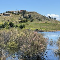
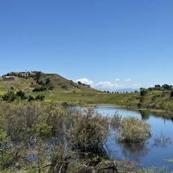
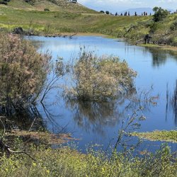
Lakes & Ponds in Granada Hills, CA
Secret Spots in Granada Hills, CA
Scenic Overlook in Granada Hills, CA
Full Moon Hike in Granada Hills, CA
Fishing Spots in Granada Hills, CA
Photo Spots in Granada Hills, CA
Secluded Spots in Granada Hills, CA
Sunrise View in Granada Hills, CA
Easy Hikes in Granada Hills, CA
Places to Watch Sunset in Granada Hills, CA
Waterfall Hike in Granada Hills, CA
Browse Nearby
BEST of Granada Hills, California Coffee near Mario DeCampos Trail
BEST of Granada Hills, California Restaurants near Mario DeCampos Trail
BEST of Granada Hills, California Things to Do near Mario DeCampos Trail
BEST of Granada Hills, California Breakfast near Mario DeCampos Trail
BEST of Granada Hills, California Walking Trails near Mario DeCampos Trail
BEST of Granada Hills, California Parks near Mario DeCampos Trail
BEST of Granada Hills, California Campgrounds near Mario DeCampos Trail
BEST of Granada Hills, California Motel near Mario DeCampos Trail
BEST of Granada Hills, California Taxis near Mario DeCampos Trail
Browse Brands
Browse Articles
People who viewed Mario DeCampos Trail also viewed
Aliso Canyon Park
80 reviews
Granada Hills
Limekiln Canyon Trail
75 reviews
Porter Ranch
The Loop Trail
5 reviews
Granada Hills
Nature Trail
4 reviews
Granada Hills
OAK SPRINGS
2 reviews
Sylmar
Serrania Ridge Trail
7 reviews
Woodland Hills
Rocky Peak Park
62 reviews
Lookout Trail
5 reviews
Granada Hills
ET Park
40 reviews
Porter Ranch
Westridge-Canyonback Wilderness Park
71 reviews
Brentwood