Lizard's Mouth Photos


You might also consider


More like Lizard's Mouth
Recommended Reviews - Lizard's Mouth
Start your review...


Reviews With Photos


Lizard's mouth is the perfect get away from the hustle and bustle of everyday life. The drive up is about 40 minutes coming from downtown Santa Barbara and is curvy, forested, and fun! There a sign that marks the trailhead and a good amount of parking on the side of the road. It's only a 5 minute walk up from the trailhead to Lizards mouth. There are a plethora of rock formations: ones to climb inside, ones to jump to and from like Lilly pads, and ones perfect for picnicking. There's a safer, flatter area that's great for kids and dogs and a little further on is a more advanced climbing area with larger boulders and crevices. Don't be alarmed if you hear gun shots in the background. There is a private gun range nearby, but they keep that area safe and secure. If you live in Santa Barbara and haven't gone up to Lizard's mouth yet, I highly recommend for a fun 1/2 day adventure.
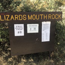

Just like the other reviews said, Lizzards Mouth isn't really much of a hike mileage wise. Depending how much you walk/climb around you can probably travel over a mile while you're here. The trail that leads in here is maybe about half a mile until you get to the rock area of the mountain. You can find Lizzards Mouth pretty quick, most of the area you'll can pretty much rock climb/hike. Up here you have an amazing view of the mountains in the distance, as well as the ocean. If you decided to venture around the rest of the area try to keep try of where you are because there are a ton of paths on the lower end of the mountain and you can get lost pretty easy since some of the paths lead you around in circles.
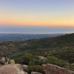

One of the best views in Santa Barbara! On the All Trails app it says it is a hard hike but it really isn't! It's only 0.3 miles but there is a lot of rock climbing! I recommend bringing a backpack with a blanket, some food, a speaker, and food company! Definitely a place you can spend all day at. For those that want to practice bouldering/ rock climbing there's a few you can practice on.


When you see the sign for the hike, go to the RIGHT of it. We went to the left and wandered aimlessly for quite a while. : / Anyway, the hike is straight after that and pretty easy. After a short amount of time, you'll get to the cliff with great views! To get to the actual Lizard's Mouth Rock, it's a bit more treacherous and we decided not to go with a toddler. But the view is good at the end of the easy part!


Beautiful gorgeous hike. Very short trail so don't worry about the distance. It's perfect during any time. Not too crowded. Great for dogs. Careful there is a good amount of rock climbing. But even a grandma can do it. There's a shooting range next door. Easy to find. Definitely worth it. You can go any route and you'll end up at the lizards mouth. Great for pictures. My top 5 hikes. Explore the architecture and look at the different rock patterns and caves. Not many lizards LOL


There are so many alternate vantage points that you can easily avoid the crowds of teenagers at sunset. The view is fantastic, in case the winding drive up didn't clue you in. It took us almost an hour to figure out the proper way to ascend the infinite scramble options, but only 20 minutes back to the road. A lot of fun if you don't mind unmarked paths, a bit of challenge, and the occasional rabbit and some stubborn lizards. It gets dark fast, so I recommend bringing a light source for your return trip, and a light jacket if it's a windy day. The graffiti is certainly unfortunate at most vantage points, and watch out for broken glass between the boulders.
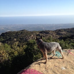

Came here on Saturday for a Yarn Bombing event! This isn't so much a trail hike as it is a labyrinth of trails! Pretty exciting, because you just adventure around looking at all sorts of stuff!, jumping on rocks and checking out the view! Heard its a great spot for bouldering or rock climbing. Took my dog and let her roam around. HOWEVER, this seems like prime rattlesnake territory so I would keep your dog on a leash for their own safety! There is graffiti on some boulders, which is thoroughly disappointing, but you can't do much about that. :[ The journey to get to this place is just that, a journey. The yelp directions did nothing, but get me lost so I had to get creative in looking for directions online. Here's how I got there, off the 101 you hop onto the 154 a few miles down the road (about 7) turn left onto West Camino Cielo and take this one lane road for about 3 miles. This road seems like you don't belong on it because it seems to only be used by residents, but once you drive down all the way you'll see the entrance to the trail head, which is a brown pipe in the ground and a wooden billboard just before the gun club. I put these into my gps (34.503055, -119.865691) and got there much more easily than the yelp directions. Once you see the pipe you just park along the side of the road.


This place was kinda hard to find. We followed directions here and trip advisor but we didn't end up at the entrance of the lizards mouth sign. It's kinda hidden. So we just started up a trail before. We also got lost and had to figure out own way to the lizards mouth. It's actually a really short hike if you start at the right point, but we didn't. Once we got up there it was pretty cool. You have to go to the side and around and down some rocks to try to get a good picture of the mouth. But once you're there it was cool. The walk back was much easier.


If you're looking for a couple hours of fun for family with kids, consider this place. Kids would love climbing around the rocks. Getting there is not very difficult but the road is narrow. GPS will not take you to the entrance but it'll stop in the middle of the road. Keep on driving up. The entrance is on the left before the gun club. If you reach the gun club, you already go too far and must turn around. When you drive down, not far from the gun club, you'll see the entrance with the sign on the right side. The sign is not curbside and it's easier to spot when driving down than driving up. Parking is on the street. There are a few large areas off street nearby the entrance. Just park in one if those areas. With a short walk on the trail, you'll teach the rocks area like a vista point with the views of Santa Barbara and the Pacific Ocean. It's windy up there so bring a light jacket or a windbreaker even in summer. Wear comfortable shoes, hat, put on sunscreen, bring water & snacks to enjoy the day. Kids will love climbing around the rocks. This place is not suitable for people with mobility problems.


This is an amazing place to explore and discover. It isn't much of a trail, more like big rocks to climb and see the view of Santa Barbara and the Pacific Ocean. If you are in this area this is definitely worth checking out. Did it with my husband and almost three year old. We all loved it!


10 years ago


12 years ago
Page 2 of 2
More info about Lizard's Mouth
Ask the Community - Lizard's Mouth
Can you camp at Lizard's Mouth?
I suppose you could. But you'll be camping on top of rocks. Large boulders. There are some flat spots.
Review Highlights - Lizard's Mouth
You might also consider












Why does Yelp recommend reviews?
1 review that is not currently recommended
The reviews below are not factored into the business's overall star rating.

9 years ago
Lizard's Mouth - hiking - Updated May 2026
Best of Goleta
People found Lizard's Mouth by searching for…
Trending Searches in Goleta, CA
Boat Rental near Lizard's Mouth
Botanical Gardens near Lizard's Mouth
Bounce House Rentals near Lizard's Mouth
Campgrounds near Lizard's Mouth
Cherry Picking near Lizard's Mouth
Cliff Jumping near Lizard's Mouth
Dog Friendly Things To Do near Lizard's Mouth
Flower Fields near Lizard's Mouth
Flower Shop near Lizard's Mouth
Garage Sales near Lizard's Mouth
Lakes & Ponds near Lizard's Mouth
Nurseries & Gardening near Lizard's Mouth
Outdoor Activities near Lizard's Mouth
Outdoor Furniture Stores near Lizard's Mouth
Party Equipment Rentals near Lizard's Mouth
Pick Your Own Farms near Lizard's Mouth
Picnic Areas near Lizard's Mouth
Places To Walk Around near Lizard's Mouth
Rainy Day Activities near Lizard's Mouth
Rock Quarry near Lizard's Mouth
Running Trails near Lizard's Mouth
Scenic Drive near Lizard's Mouth
Secret Spots near Lizard's Mouth
Strawberry Picking near Lizard's Mouth
Sunrise View near Lizard's Mouth
Swimming Holes near Lizard's Mouth
Browse Articles
Browse Nearby
BEST of Goleta, California Restaurants near Lizard's Mouth
BEST of Goleta, California Coffee near Lizard's Mouth
BEST of Goleta, California Breakfast near Lizard's Mouth
BEST of Goleta, California Things to Do near Lizard's Mouth
BEST of Goleta, California Wineries near Lizard's Mouth
Browse Brands
Related Searches in Goleta, CA
Affordable Kayak Rental Services in Goleta, California
Best Fishing Locations and Guides in Goleta, California
Best Places for Horseback Riding in Goleta, California
Best Waterfalls and Swimming Holes in Goleta, California
Check Out Off Road Trails in Goleta, California
Discover Dog Friendly Trails to Explore in Goleta, California
Discover Kid Friendly Hiking Trails in Goleta, California
Discover Scenic Waterfall Spots in Goleta, California
Discover a Hiking Trail in Goleta, California
Discover the Best Night Hike Trails in Goleta, California
Dog-Friendly Hikes With Dogs in Goleta, California
Enjoy Camping Adventures Around Goleta, California
Enjoy Exciting Mountain Biking Adventures in Goleta, California
Enjoy Kayaking Adventures in Goleta, California
Enjoy Tent Camping Spots Around Goleta, California
Enjoy a Beautiful Waterfall Hike in Goleta, California
Enjoy the Best Picnic Spots and Ideas in Goleta, California
Enjoy the Best Walking Trails in Goleta, California
Exciting Cliff Jumping Spots in Goleta, California
Explore Beautiful Parks and Green Spaces in Goleta, California
Explore Easy Hikes Perfect for All in Goleta, California
Explore Fun Activities to Do in Goleta, California
Explore Popular Campgrounds Near Goleta, California
Explore Top Dog Parks in Goleta, California Near You
Explore the Best Beach Spots in Goleta, California
Explore the Best Swimming Holes Around Goleta, California
Explore the Best Trail Options in Goleta, California
Find Beautiful Views in Goleta, California
Find Popular Ziplining Spots Around Goleta, California
Find the Best Parks for Picnics in Goleta, California
Find the Best Playgrounds to Visit in Goleta, California
Find the Best Scenic View Locations in Goleta, California
Great Places to Walk in Goleta, California
Hike the Popular Waterfall Trail in Goleta, California
Hiking Trails With Waterfalls in Goleta, California
Off Leash Dog Hiking Trails in Goleta, California
Plan a Scenic Drive Route Near Goleta, California
Popular Outdoor Activities to Try in Goleta, California
Popular Picnic Spots to Visit in Goleta, California
Popular Things to Do in Goleta, California
Safe River Swimming Areas in Goleta, California
Safe and Fun Parks for Kids in Goleta, California
Top Climbing Spots and Gyms in Goleta, California
Top Paddleboarding Activities in Goleta, California
Top Places for Snorkeling in Goleta, California
Top Playgrounds for Kids to Enjoy in Goleta, California
Top Running Trails to Explore in Goleta, California
Top Swimming Spots and Pools in Goleta, California


