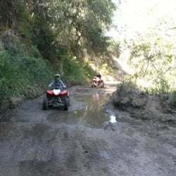
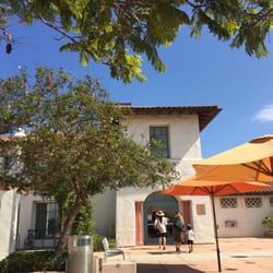
Cold Spring Trail Photos


You might also consider
More like Cold Spring Trail
Recommended Reviews - Cold Spring Trail
Start your review...

Reviews With Photos


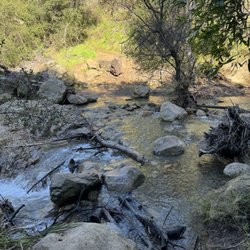
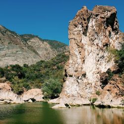
A friendly local showed us which of the trails to take to do the Cold Springs loop. We ended up going counterclockwise, getting the steeper part out of the way first and more shade on the way down. Some signage but at times confusing (we had to backtrack twice). Two creek crossings as mentioned by others. Lots of wildflowers, beautiful views, nice little waterfall. Some poison oak to watch out for but they weren't encroaching on the well maintained trail (though narrow in parts).

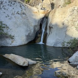
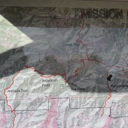
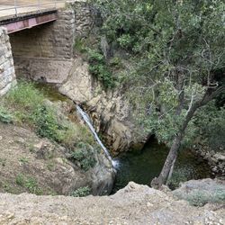
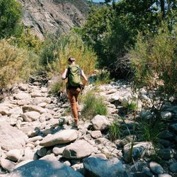
Review for East Fork Cold Springs Trail: You can get literally lost in the wilderness along Cold Springs Trail. There are so many off-shoots and intersections that make it into a labyrinth for the unfamiliar...not to mention its difficulty! If you're like me and: 1) Like to increase your heart rate but not cause a heart attack 2) Enjoy a prize along the way (a small waterfall in this case), then the EAST Fork of the Cold Springs Trail is for you! Parking on the weekends can be insane because it is the same location as three popular trails: Tangerine Falls, West Fork Cold Springs and East Fork Cold Springs. Prepare to walk an additional half a mile or more from where you park your car. Begin on the Tangerine Falls trail along the Cold Springs Creek until you hit a Y, then be sure to veer to the right. The trail will then switchback up, up and away. Side note: After the Montecito Mud Slide on January 9th of 2018, you'll get to see the strong chain loop fences along the creek here. You'll eventually see a small waterfall in the distance which is your destination. Once you arrive to the falls, you can choose to turn around, however, you're already at quite an altitude so continue on for some of the best views of Santa Barbara and the Channel Islands via the Ridge Trail to make a loop back to the trailhead. You'll also see the historic Tea House Arches in the distance opposite from you. Happy Trails!

The loop on Cold Spring trail is a nice, relatively easy 2-3 hour hiking trail that has you crossing some cool streams and shaded forests for virtually the entire way. If you want to get better views of the city then I would recommend making a detour to the Edison Catway and climb up to the top to get a good view of SB/Montecito. Trailhead starts here on Google Maps: 824 East Mountain Dr Montecito, CA 93108 Didn't go all the way up to Camino Cielo (The Road at the top ridge), but I'll have to try next time. Most of the loop does not have views, but with a steady uphill slope you definitely need some decent legs to go up. If you want to go to see some views take the East Fork or turn right on the trail after the bench. If you want Tangerine Falls, turn left of the bench and cross the creek. Bring an extra pair of shoes because after a rain the ground gets damp and the creeks get filled after the rain. For first timers this is a great place to start if you want to like the SB front country.

If you're looking for a quick and mostly easy hike, this could be the one! I hiked this with my friend, and we didn't have much time before sundown, so we were racing to get to the top. We almost turned back, but we trudged on and made it to the Montecito overlook in time before the sun set! It was only about 1.5 mi up to get there, and you see a nice overview of the city and the ocean. A few steep parts but not bad, and there were lots of trees for shade. Another review says there's poison oak, but I wasn't aware of this and did the hike in shorts and was okay. But now that you've been warned, you might not want to take your chances!


GREAT FOR KIDS! If you have kids, this is a very fun little hike because of the many opportunities it gives the kiddies to find frogs and salamanders along the way! I'm not talking the full hike, just the bottom parts that have creek crossings. Let's be honest, little legs can only go so far .

So we wake up and my husband is all like, "Do you want to go on a leisurely hike in Montecito?" "Of course!" 3 hours later, this loop is a little less than leisurely. We had done some quick research and read that the trails are not clearly marked but when in doubt, keep right. Keeping right at times involved short cuts with dramatic inclines and getting lost among the oak trees. Don't get me wrong, this hike is fantastic. And the view at the top is well worth the sweat. (270 degrees + full coastline.) But unless you're very familiar with the trail, you may encounter a few wrong turns and big climbs. It'd be great if the town would add some more signage to the route or markings on trees. Nevertheless, if you want to take in the beauty that is Santa Barbara and are feeling adventurous, I highly recommend!

Love love love this hike. It's a very easy hike to do in a hurry if you have work later. It's quick and works you out as well as getting amazing views of Santa Barbara. This hike is located in Montecito. I agent been up there since the fire and I'm terrified it was destroyed. This is one of my favorite hikes to go to. And my dog loves it as well since it's not very strenuous. Once u get to the top you get an amazing view and there are always rocks on top in nice like designs you can do yourself. If this hike is still in place after the fire. I would recommend checking it out!!

We planned to take the Tangerine falls hike which starts on Cold springs and forks to right a mile or so into the hike. Ive reviewd this trail before, however, due to the rain, the trail looks completely different. The trail was crowded(we started around noon on a Sat), especially towards the beginning. The "hazardous..."is no longer there so we missed it and had to backtrack. Look instead for the blue flags. Towards the end, the trail becomes a lot of rock climbing... wear good shoes with tread. In addition, the whole Trail is covered in poison oak making long pants a necessity if you're allergic.

Beautiful woodsy, shaded trail with a gradual incline. I missed the split to do the loop and ended up doing the Montecito Peak which is beautiful. It's woodsy through out- you will get no sun on this trail up until the Peak. It doesn't attract too many people, I ran into a couple of first timers and others that appear to live in the area. Friendly people in this area, always bring water. Some first timers on this trail didn't have any water, even if shaded you can die from heat exhaustion. Driving here from the 101 is really pretty, the area is just filled with big green tress on these beautiful park like estate properties. Along this trail you will find a split right where the bench is- That may have been where I should have turn to do the 3 mile loop that I had planned to do but I kept going straight. Once I crossed the creek there was a sign posted to the left that said Route Closed. That may have also been the turn to do the loop, I'm not sure. There are no clear directions on these signs other than at the entrance listing the names of the trails. So I kept straight and ended up at the peak with no loop. I would love to come back and explore the turn off's it's so pretty in here. The incline to the Peak is easy and worth doing.
")
This is my go-to trail in the SB area. I LOVE coming here. I usually do the East fork. The entire early portion of the trail is in the shade and follows the creek, making for a cool hike. Once you pass the electrical towers, the trail is a lot dryer and mostly in the sun but still enjoyable. For a little variation you could do the West Fork of the trail but it is quite a bit shorter. The West Fork is across the creek at the bench, about a quarter mile in. The East Fork is about 9 miles roundtrip while the West Fork is 3 to 3.5 miles roundtrip. If you are short on time there are some awesome views of SB and Montecito from the electrical towers and it's only about a mile and a half up. This makes for a quick, relaxing hike. The only thing I don't enjoy about coming here are the large amounts of people who also enjoy it. I can't stand going out for a relaxing hike only to be followed by a group of 5 women chatting the entire way. I generally avoid this trail on the weekends because it can become very busy and there is limited parking. The best time I have found to start out is early weekday mornings.

My friend and I hiked this 2 mile easy trail on a Tuesday morning. It was great! Temperature was mild, there is quite a bit of shade throughout the hike. The waterfalls are small but beautiful. There were not a lot of people when we hiked, maybe we saw 8 people max through out the hike. To Note: there is A LOT of Poison Ivy-Oak. I wore light long hiking pants. There are some stretches with no shade so wear sunscreen if sensitive to sun. Great if you are time limited, short hike. Landscape: little waterfalls, there is limited parking. read more


2 months ago
If you're going to Cold Spring Tavern, you can also hike around the area and enjoy the marvelous views and do some bird watching. Theres blue jays and finches all around and they are not scared of people so you can get some great pictures. There's also lots of butterflies. read more


2 months ago
5 months ago
Yeah it's okay. If you want an easy workout this is the spot for you. Some major river crossings. Very steep. If you're a veteran hiker this is for you. Not too many photo ops. Probably won't be back lol. Don't burn the spot. Lol read more


A friendly local showed us which of the trails to take to do the Cold Springs loop. We ended up going counterclockwise, getting the steeper part out of the way first and more shade on the way down. Some signage but at times confusing (we had to backtrack twice). Two creek crossings as mentioned by others. Lots of wildflowers, beautiful views, nice little waterfall. Some poison oak to watch out for but they weren't encroaching on the well maintained trail (though narrow in parts). read more


1 year ago
Review for East Fork Cold Springs Trail: You can get literally lost in the wilderness along Cold Springs Trail. There are so many off-shoots and intersections that make it into a labyrinth for the unfamiliar...not to mention its difficulty! If you're like me and: 1) Like to increase your heart rate but not cause a heart attack 2) Enjoy a prize along the way (a small waterfall in this case), then the EAST Fork of the Cold Springs Trail is for you! Parking on the weekends can be insane because it is the same location as three popular trails: Tangerine Falls, West Fork Cold Springs and East Fork Cold Springs. Prepare to walk an additional half a mile or more from where you park your car. Begin on the Tangerine Falls trail along the Cold Springs Creek until you hit a Y, then be sure to veer to the right. The trail will then switchback up, up and away. Side note: After the Montecito Mud Slide on January 9th of 2018, you'll get to see the strong chain loop fences along the creek here. You'll eventually see a small waterfall in the distance which is your destination. Once you arrive to the falls, you can choose to turn around, however, you're already at quite an altitude so continue on for some of the best views of Santa Barbara and the Channel Islands via the Ridge Trail to make a loop back to the trailhead. You'll also see the historic Tea House Arches in the distance opposite from you. Happy Trails! read more


2 years ago
4 years ago
The loop on Cold Spring trail is a nice, relatively easy 2-3 hour hiking trail that has you crossing some cool streams and shaded forests for virtually the entire way. If you want to get better views of the city then I would recommend making a detour to the Edison Catway and climb up to the top to get a good view of SB/Montecito. Trailhead starts here on Google Maps: 824 East Mountain Dr Montecito, CA 93108 Didn't go all the way up to Camino Cielo (The Road at the top ridge), but I'll have to try next time. Most of the loop does not have views, but with a steady uphill slope you definitely need some decent legs to go up. If you want to go to see some views take the East Fork or turn right on the trail after the bench. If you want Tangerine Falls, turn left of the bench and cross the creek. Bring an extra pair of shoes because after a rain the ground gets damp and the creeks get filled after the rain. For first timers this is a great place to start if you want to like the SB front country. read more


15 years ago
If you're looking for a quick and mostly easy hike, this could be the one! I hiked this with my friend, and we didn't have much time before sundown, so we were racing to get to the top. We almost turned back, but we trudged on and made it to the Montecito overlook in time before the sun set! It was only about 1.5 mi up to get there, and you see a nice overview of the city and the ocean. A few steep parts but not bad, and there were lots of trees for shade. Another review says there's poison oak, but I wasn't aware of this and did the hike in shorts and was okay. But now that you've been warned, you might not want to take your chances! read more


6 years ago
Just hiked this trail and it's really beautiful right now. The trail is full of green and yellow with a lot of budding flowers. Next week, after all this rain, it's really going to explode in color. Oh and nice little water falls flowing too. Can't wait to hike it again! read more


11 years ago
GREAT FOR KIDS! If you have kids, this is a very fun little hike because of the many opportunities it gives the kiddies to find frogs and salamanders along the way! I'm not talking the full hike, just the bottom parts that have creek crossings. Let's be honest, little legs can only go so far . read more

12 years ago
So we wake up and my husband is all like, "Do you want to go on a leisurely hike in Montecito?" "Of course!" 3 hours later, this loop is a little less than leisurely. We had done some quick research and read that the trails are not clearly marked but when in doubt, keep right. Keeping right at times involved short cuts with dramatic inclines and getting lost among the oak trees. Don't get me wrong, this hike is fantastic. And the view at the top is well worth the sweat. (270 degrees + full coastline.) But unless you're very familiar with the trail, you may encounter a few wrong turns and big climbs. It'd be great if the town would add some more signage to the route or markings on trees. Nevertheless, if you want to take in the beauty that is Santa Barbara and are feeling adventurous, I highly recommend! read more

Love love love this hike. It's a very easy hike to do in a hurry if you have work later. It's quick and works you out as well as getting amazing views of Santa Barbara. This hike is located in Montecito. I agent been up there since the fire and I'm terrified it was destroyed. This is one of my favorite hikes to go to. And my dog loves it as well since it's not very strenuous. Once u get to the top you get an amazing view and there are always rocks on top in nice like designs you can do yourself. If this hike is still in place after the fire. I would recommend checking it out!! read more


9 years ago
We planned to take the Tangerine falls hike which starts on Cold springs and forks to right a mile or so into the hike. Ive reviewd this trail before, however, due to the rain, the trail looks completely different. The trail was crowded(we started around noon on a Sat), especially towards the beginning. The "hazardous..."is no longer there so we missed it and had to backtrack. Look instead for the blue flags. Towards the end, the trail becomes a lot of rock climbing... wear good shoes with tread. In addition, the whole Trail is covered in poison oak making long pants a necessity if you're allergic. read more


Beautiful woodsy, shaded trail with a gradual incline. I missed the split to do the loop and ended up doing the Montecito Peak which is beautiful. It's woodsy through out- you will get no sun on this trail up until the Peak. It doesn't attract too many people, I ran into a couple of first timers and others that appear to live in the area. Friendly people in this area, always bring water. Some first timers on this trail didn't have any water, even if shaded you can die from heat exhaustion. Driving here from the 101 is really pretty, the area is just filled with big green tress on these beautiful park like estate properties. Along this trail you will find a split right where the bench is- That may have been where I should have turn to do the 3 mile loop that I had planned to do but I kept going straight. Once I crossed the creek there was a sign posted to the left that said Route Closed. That may have also been the turn to do the loop, I'm not sure. There are no clear directions on these signs other than at the entrance listing the names of the trails. So I kept straight and ended up at the peak with no loop. I would love to come back and explore the turn off's it's so pretty in here. The incline to the Peak is easy and worth doing. read more


16 years ago
This is my go-to trail in the SB area. I LOVE coming here. I usually do the East fork. The entire early portion of the trail is in the shade and follows the creek, making for a cool hike. Once you pass the electrical towers, the trail is a lot dryer and mostly in the sun but still enjoyable. For a little variation you could do the West Fork of the trail but it is quite a bit shorter. The West Fork is across the creek at the bench, about a quarter mile in. The East Fork is about 9 miles roundtrip while the West Fork is 3 to 3.5 miles roundtrip. If you are short on time there are some awesome views of SB and Montecito from the electrical towers and it's only about a mile and a half up. This makes for a quick, relaxing hike. The only thing I don't enjoy about coming here are the large amounts of people who also enjoy it. I can't stand going out for a relaxing hike only to be followed by a group of 5 women chatting the entire way. I generally avoid this trail on the weekends because it can become very busy and there is limited parking. The best time I have found to start out is early weekday mornings. read more
 - Hiking Near Me - Santa Barbara, California")

 - Hiking Near Me - Santa Barbara, California")


12 years ago
Fun hike... Cool to check out the over the top mansions. The trail is great for pups... Ours had a blast. Though the trails are marked, it's difficult to distinguish which is the 2 mile hike and which is .5 Next time we are in town, we will try a different trail, but it was worth it to check this one out! read more

13 years ago
12 years ago
12 years ago
15 years ago
13 years ago

12 years ago
Start early if it's your first time. I'm an avid hiker and athlete and it took me almost 2 hours to reach the top of Camino de Cielo (I went on dead end paths every so often and they're not so obvious to me). Sometimes I questioned if I was even on a trail, but that made it fun! The view from the top was just gorgeous and I was lucky enough to find to other gals who could take my picture. Once you get closer to the top, the loose gravel makes it tough but interesting. I love a challenge! read more

9 years ago
11 years ago
11 years ago
13 years ago
More info about Cold Spring Trail
Ask the Community - Cold Spring Trail
Review Highlights - Cold Spring Trail
You might also consider


Why does Yelp recommend reviews?
Cold Spring Trail - hiking - Updated June 2026
Best of Santa Barbara
People found Cold Spring Trail by searching for…
Hot Springs in Santa Barbara, California
Hiking Trails in Santa Barbara, California
Waterfall Hike in Santa Barbara, California
Easy Hikes in Santa Barbara, California
Rock Climbing in Santa Barbara, California
Stairs Workout in Santa Barbara, California
Scenic View in Santa Barbara, California
Off Road Trails in Santa Barbara, California
Attractions in Santa Barbara, California
Free Campgrounds in Santa Barbara, California
Places to Take Pictures in Santa Barbara, California
Parks in Santa Barbara, California
Walking Trails in Santa Barbara, California
Dog Friendly Hiking Trails in Santa Barbara, California
Picnic Areas in Santa Barbara, California
Lookout Points in Santa Barbara, California
Picnic Spots in Santa Barbara, California
Stair Climbing in Santa Barbara, California
Waterfalls in Santa Barbara, California
Things to Do With Teenagers in Santa Barbara, California
Swimming Lakes in Santa Barbara, California
Playgrounds in Santa Barbara, California
Trending Searches in Santa Barbara, CA
Bait And Tackle Shop near Cold Spring Trail
Black Owned Nail Salons near Cold Spring Trail
Boat Rental near Cold Spring Trail
Cliff Jumping near Cold Spring Trail
Day Trips near Cold Spring Trail
Dog Friendly Trails near Cold Spring Trail
Fishing Spots near Cold Spring Trail
Jet Ski Rental near Cold Spring Trail
Kayak Rental near Cold Spring Trail
Lakes & Ponds near Cold Spring Trail
Outdoor Activities near Cold Spring Trail
Pick Your Own Farms near Cold Spring Trail
Places To Walk Around near Cold Spring Trail
Public Shower near Cold Spring Trail
River Swimming near Cold Spring Trail
Rock Quarry near Cold Spring Trail
Scenic Night View near Cold Spring Trail
Scenic Overlook near Cold Spring Trail
Secluded Spots near Cold Spring Trail
Soccer Store near Cold Spring Trail
Splash Pad near Cold Spring Trail
Strawberry Picking near Cold Spring Trail
Sunrise View near Cold Spring Trail
Swimming Holes near Cold Spring Trail
Swimming Lakes near Cold Spring Trail
Swimming Pools near Cold Spring Trail
Watch Sunset near Cold Spring Trail
Browse Articles
Browse Nearby
BEST of Santa Barbara, California Things to Do near Cold Spring Trail
BEST of Santa Barbara, California Coffee near Cold Spring Trail
BEST of Santa Barbara, California Restaurants near Cold Spring Trail
BEST of Santa Barbara, California Breakfast near Cold Spring Trail
BEST of Santa Barbara, California Hot Springs near Cold Spring Trail
BEST of Santa Barbara, California Wineries near Cold Spring Trail
Browse Brands
Related Searches in Santa Barbara, CA
Affordable Kayak Rental Services in Santa Barbara, California
Best Fishing Locations and Guides in Santa Barbara, California
Best Places for Horseback Riding in Santa Barbara, California
Best Waterfalls and Swimming Holes in Santa Barbara, California
Check Out Off Road Trails in Santa Barbara, California
Discover Dog Friendly Trails to Explore in Santa Barbara, California
Discover Kid Friendly Hiking Trails in Santa Barbara, California
Discover Scenic Waterfall Spots in Santa Barbara, California
Discover a Hiking Trail in Santa Barbara, California
Discover the Best Night Hike Trails in Santa Barbara, California
Dog-Friendly Hikes With Dogs in Santa Barbara, California
Enjoy Camping Adventures Around Santa Barbara, California
Enjoy Exciting Mountain Biking Adventures in Santa Barbara, California
Enjoy Kayaking Adventures in Santa Barbara, California
Enjoy Tent Camping Spots Around Santa Barbara, California
Enjoy a Beautiful Waterfall Hike in Santa Barbara, California
Enjoy a Peaceful Nature Walk in Santa Barbara, California
Enjoy the Best Picnic Spots and Ideas in Santa Barbara, California
Enjoy the Best Walking Path in Santa Barbara, California
Enjoy the Best Walking Trails in Santa Barbara, California
Exciting Cliff Jumping Spots in Santa Barbara, California
Explore Beautiful Parks and Green Spaces in Santa Barbara, California
Explore Easy Hikes Perfect for All in Santa Barbara, California
Explore Fun Activities to Do in Santa Barbara, California
Explore Popular Campgrounds Near Santa Barbara, California
Explore the Best Beach Spots in Santa Barbara, California
Explore the Best Swimming Holes Around Santa Barbara, California
Explore the Best Trail Options in Santa Barbara, California
Family Friendly Hiking With Kids in Santa Barbara, California
Find Beautiful Views in Santa Barbara, California
Find Popular Ziplining Spots Around Santa Barbara, California
Find the Best Parks for Picnics in Santa Barbara, California
Find the Best Scenic View Locations in Santa Barbara, California
Great Places to Walk in Santa Barbara, California
Hike the Popular Waterfall Trail in Santa Barbara, California
Hiking Trails With Waterfalls in Santa Barbara, California
Off Leash Dog Hiking Trails in Santa Barbara, California
Plan a Scenic Drive Route Near Santa Barbara, California
Play at a Splash Pad Park in Santa Barbara, California
Popular Outdoor Activities to Try in Santa Barbara, California
Popular Picnic Spots to Visit in Santa Barbara, California
Popular Things to Do in Santa Barbara, California
Safe River Swimming Areas in Santa Barbara, California
Safe and Fun Parks for Kids in Santa Barbara, California
Top Climbing Spots and Gyms in Santa Barbara, California
Top Places for Snorkeling in Santa Barbara, California
Top Playgrounds for Kids to Enjoy in Santa Barbara, California
Top Running Trails to Explore in Santa Barbara, California
Top Swimming Spots and Pools in Santa Barbara, California
Walk Dog Friendly Hiking Trails in Santa Barbara, California