Inspiration Point Photos


You might also consider
More like Inspiration Point
Recommended Reviews - Inspiration Point
Start your review...

Reviews With Photos

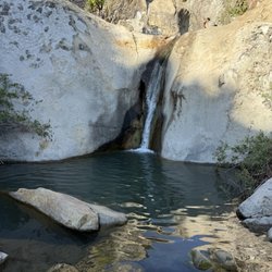
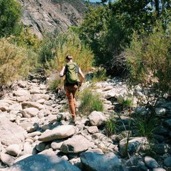
Luckily for us, we know someone who lives just below the start of the trail head so we were fortunate to pass by all the other hikers trudging up the hill to get to the head. I'm not sure I'd commit to the hike if I had to anticipate the parking struggle. The extra trudging can add a good extra 15 minutes uphill. The first 30 minutes of the hike is on pavement with some views of the valley and ocean and one bridge over a creek: not too exciting, but worth it for the greenery and creek beds that come next. The trail splits off into different routes (a map is provided at the forks). Our favorite route goes to what is called 3 pools. It's 30 minutes past the first run in with the creek bed. The beginning gets your lungs breathing heavy but after those 10 minutes it's a fun 20 minute dance along the rocky trail DOWN to the pools. (That's right, DOWN, no more uphill. Hooray!) it's a great spot for a picnic if you plan ahead, unlike us. Our french bulldog easily navigated the Rocky trails and was having a total blast off leash, but be careful at some of the view points because it could be an easy tumble down for your furry friend.

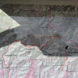
3.4 miles RT from tunnel rd. Moderate level difficulty. 1.45 to 2 hours RT total hiking time. 1,800 ft above Santa Barbara coast and 935 ft gain. Beautiful panoramic view of the Santa Barbara coast and city. Popular location with locals. There is a map at one the main junctions. However, one critique I had was that a junction had no official signage at all which left my friend and me lost for a bit. See picture*. Parts of the trail in the beginning are paved. I didn't see any bathrooms at base as there are few street parking and homes. Few dog walkers here with some that don't pick up after their pet. I wished the city maintained the trail a bit more as some parts of the trail were slippery and had no traction even with my hiking boots. Plan on bringing sufficient amount of water and snacks. Many hikers and locals hike late around 6 PM to catch the sunset. However, it would be unwise to go if you weren't experienced, didn't have headlamps or a flashlight for the trek back. At the peak, you'll stare in awe and amazement for the picturesque views of Santa Barbara. You can also take longer journey/detour to the Jesuita trail.

As of 6/29, this hike is open to the public. We started at the Inspiration Point Trailhead and it's about a 4mile, 2-3 hour hike of moderate intensity. The first half is paved and the second half requires going over some rocks so recommend a good pair of hiking shoes. Like others have said, the trail isn't well marked, but if you keep making lefts at each fork, you'll get to the destination. On a clear day, you'll get great views of Santa Barbara and also be able to see the Channel Islands. Minus-1 Star for the parking situation. There is NO parking lot and very minimal street parking so be prepared to take a "mini-hike" from wherever you find parking to the start of the trailhead.

There seems to be at least 4 different trails that lead to Inspiration Point, one being Jesusita Trail which I took to get here, Stevens Park is another, & the other 2 I forgot but once you make it up to the peak you can see there are two other paths that lead here. This spot has some great views of to the south & west of Santa Barbara County. Despite the ocean being overcast I still got some decent shots of the view, but trust me the picture don't do this spot that much justice. Even though this is just my first hike of a mountain in the Santa Barbara area getting up to this point for the view is totally worth it.


Whether you're a Santa Barbara local, new to town or visiting, Inspiration Point is the hike to do! As an SB local myself, Inspiration has always been my favorite. I usually meet a friend at the Mission, then take one car to park on Mission Canyon as spaces can be sparse. Make sure you stay to the left in the beginning to avoid the dead end steep hill! I would say the hike is fairly moderate, with a breathtaking and well deserved view at the top! Bring water!

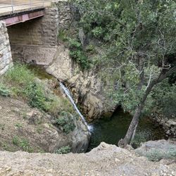
This hike this morning was awesome, it came highly recommended by the workers at the hostel I'm staying at, so I went to give it a try. Upon driving up to the area, be aware that you need to park on the side of the road, so if there are a lot of cars up ahead, just grab the first spot you see and get ready for the uphill climb to the base of the trails . So then you reach the trailhead, and already, you have views. Beautiful scenic shots of the ocean and SB, beautiful. The first part of the trail is paved and comfortable. Easy walk up the path and a fun little waterfall along the way, it was nice. Then, once the path becomes dirt and unpaved, the real hiking begins. And I went towards Inspiration Point up the hills, and I'd say it's a low Medium-Easy hike to get up there. But remember, bring water. There are no fountains. Also, be careful of THE MUD. The mud was pretty thick on the way up, and it almost ate my shoe as I was trudging through it. So be wary. And also, enjoy the dogs on the path. The waterfalls are beautiful, and the scene from the top is breathtaking. This hike is a 5 star hike.

We hiked here late afternoon and got one of the last parking spaces before the road ends at the water tower. You'll hike up a fire road for a while before hitting the trail head. We talked to a few folks who were headed to or coming from the right branch, so we headed left up to inspiration point. The observation point is not very far from the trail head but it's a steep climb. Wonderful tranquility and views all along the trail and at the overlook (at the power line tower). We went in September and the sun was still pretty far north. Had hoped to see it set over Santa Barbara. Would like to come back closer to the solstice to see how much further south the sun sets. Nice view of Santa Barbara. In my photo the mission is in the middle and the harbor to the left. UPDATE: after reading a description of this hike on AllTrails, I'm not sure we were on the right trail. Anyway, we had a steep, but nice hike up to the power lines, and were rewarded with a nice view.

Good quick hike about 3.6 miles. Finished in 2 hours even a slow pace. It was not difficult and dog friendly. It had a few rocks to navigate up so felt like small adventure to a view point at end. Not spectacular ending but it was nice spot to snap a pic. We thought we went early at 7am but most of the parking already taken and we took the last parking spot on side of road. We still had to hike like 0.3 miles to trailhead.

The view is awesome, just be sure to know where you're going before you leave for the point. Enter this in Google Maps to get there: Spyglass Ridge Rd, Santa Barbara, CA 93105 ------------------------------------------------ When you're on Mission Canyon Road, you'll have to park on the side street. There's no public parking, and be sure to be within the curb to not get towed. Once you're up there, go right of the water tower and KEEP HEADING on the FIRST LEFT of every fork in the trail until you're at the top of the mountain. From there, cross the junction and you'll see a wonderful view of Santa Barbara. The hike is easy but not totally flat, so bring 2 bottles of water per person since the hike itself is about 2 hours round trip and on a summer afternoon, it can get pretty hot.

The views at the top are so worth the trek. Hiked the trail to Inspiration Point this morning from the end of Tunnel Road. Some mention that it's a short hike - and they're correct, but it's still a good 2+ hours of activity. The hike is mostly uphill to the point and can be fairly deceiving as there aren't really specific markers. I'd read other reviews where they state to take a left at the "yield" sign. The area mentioned did not have a yield sign (it appears to have been removed), but I did note an upside-down brown triangle which I believe was the bottom portion of the original sign. You will want to take a left here. It's the rockier/narrower of the two paths at this particular fork but it's the correct one. The trail was fairly busy when I hiked it this morning. I must say that it was in very good condition. Whomever maintains it has been doing a great job. The majority of it meanders through beautiful local vegetation and is just gorgeous. The prize is at the top where you get to view Santa Barbara panoramically. What a view. There are plenty of spots to stand and take in the views and sounds of the nearby birds (and chickens in a coop down on Tunnel Road along the street parking area - you can hear them clucking away even from the top!). Not an easy hike but a very rewarding one to say the least. I will be back soon.

Inspiration Point trail is a easy to moderate hike. The trail can be reached from the Tunnel Road trail (I've done it and this review is based off that) or from the Jesusita Trail (which I have not done). About the hike- Approximately 4.5 miles roundtrip, the trail does not loop. Perfect for morning or late afternoon, although there are few shaded areas you don't want to be hiking in the strong midday sun. The trail is not just uphill but varies between level, uphill, and downhill throughout all while making an elevation gain of about 800ft. How to get there- Take Foothills Road Mission Canyon Road, when the road forks keep left onto Tunnel Road which you will take until the end and park. Walk along the paved road until you reach the trail head. At the top- Once you reach the top the view is, well, inspirational. Spectacular views of Santa Barbara and the ocean. Great picture opportunity. There are reptiles, birds, and other wildlife on the hike. It's a great location with other trails in the area to try as well.

One word: INSPIRATIONAL :D It's a great hike which took my two friends and I going up about 45 minutes with some upward incline, lizard spotting, greeting fellow hikers and watching not to trip and fall lol At the top you can see all of Santa Barbara, Goleta, and UCSB. Pretty cool view with sunny weather to accommodate it :)
")
2 months ago


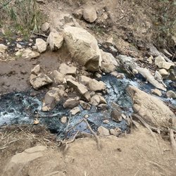
This was a mid/challenging hike depending if there is a lot of mud after the rain. When we came there were streams that we had to cross over via rock steps. If you're not careful you can easily fall in. Also there was a recent rock slide that occurred but you can easily navigate around. After the 1.75 miles journey up, the view was breathtaking and worth. You can enjoy the great view Santa Barbara and the ocean. Total 3.5-4 mile hike dependent on where you parked. Parking is right at the entrance on the side of street. Luckily it was empty because I went on a Monday but I assume it could be filled up on weekends so probably come early. read more


3 years ago
Although parking at the trail head can be hard to find on the public street, this hike is worth a couple extra steps if parking lower than you planned. Recommend going earlier in day or towards evening as the initial part of the hike is pretty sunny and along a paved road. It is about 3.5 miles round trip and up the whole way. Once there, the views of Santa Barbara make the trip well worth it. Take some water and relax along the way, you won't regret this when you are done! read more


Luckily for us, we know someone who lives just below the start of the trail head so we were fortunate to pass by all the other hikers trudging up the hill to get to the head. I'm not sure I'd commit to the hike if I had to anticipate the parking struggle. The extra trudging can add a good extra 15 minutes uphill. The first 30 minutes of the hike is on pavement with some views of the valley and ocean and one bridge over a creek: not too exciting, but worth it for the greenery and creek beds that come next. The trail splits off into different routes (a map is provided at the forks). Our favorite route goes to what is called 3 pools. It's 30 minutes past the first run in with the creek bed. The beginning gets your lungs breathing heavy but after those 10 minutes it's a fun 20 minute dance along the rocky trail DOWN to the pools. (That's right, DOWN, no more uphill. Hooray!) it's a great spot for a picnic if you plan ahead, unlike us. Our french bulldog easily navigated the Rocky trails and was having a total blast off leash, but be careful at some of the view points because it could be an easy tumble down for your furry friend. read more


3.4 miles RT from tunnel rd. Moderate level difficulty. 1.45 to 2 hours RT total hiking time. 1,800 ft above Santa Barbara coast and 935 ft gain. Beautiful panoramic view of the Santa Barbara coast and city. Popular location with locals. There is a map at one the main junctions. However, one critique I had was that a junction had no official signage at all which left my friend and me lost for a bit. See picture*. Parts of the trail in the beginning are paved. I didn't see any bathrooms at base as there are few street parking and homes. Few dog walkers here with some that don't pick up after their pet. I wished the city maintained the trail a bit more as some parts of the trail were slippery and had no traction even with my hiking boots. Plan on bringing sufficient amount of water and snacks. Many hikers and locals hike late around 6 PM to catch the sunset. However, it would be unwise to go if you weren't experienced, didn't have headlamps or a flashlight for the trek back. At the peak, you'll stare in awe and amazement for the picturesque views of Santa Barbara. You can also take longer journey/detour to the Jesuita trail. read more


6 years ago
As of 6/29, this hike is open to the public. We started at the Inspiration Point Trailhead and it's about a 4mile, 2-3 hour hike of moderate intensity. The first half is paved and the second half requires going over some rocks so recommend a good pair of hiking shoes. Like others have said, the trail isn't well marked, but if you keep making lefts at each fork, you'll get to the destination. On a clear day, you'll get great views of Santa Barbara and also be able to see the Channel Islands. Minus-1 Star for the parking situation. There is NO parking lot and very minimal street parking so be prepared to take a "mini-hike" from wherever you find parking to the start of the trailhead. read more


There seems to be at least 4 different trails that lead to Inspiration Point, one being Jesusita Trail which I took to get here, Stevens Park is another, & the other 2 I forgot but once you make it up to the peak you can see there are two other paths that lead here. This spot has some great views of to the south & west of Santa Barbara County. Despite the ocean being overcast I still got some decent shots of the view, but trust me the picture don't do this spot that much justice. Even though this is just my first hike of a mountain in the Santa Barbara area getting up to this point for the view is totally worth it. read more


4 years ago
Nice views Hike through the oaks on a well maintained trail. Close to town And from the top you can see the whole beach below Not too crowded even on weekends read more

Whether you're a Santa Barbara local, new to town or visiting, Inspiration Point is the hike to do! As an SB local myself, Inspiration has always been my favorite. I usually meet a friend at the Mission, then take one car to park on Mission Canyon as spaces can be sparse. Make sure you stay to the left in the beginning to avoid the dead end steep hill! I would say the hike is fairly moderate, with a breathtaking and well deserved view at the top! Bring water! read more

This hike this morning was awesome, it came highly recommended by the workers at the hostel I'm staying at, so I went to give it a try. Upon driving up to the area, be aware that you need to park on the side of the road, so if there are a lot of cars up ahead, just grab the first spot you see and get ready for the uphill climb to the base of the trails . So then you reach the trailhead, and already, you have views. Beautiful scenic shots of the ocean and SB, beautiful. The first part of the trail is paved and comfortable. Easy walk up the path and a fun little waterfall along the way, it was nice. Then, once the path becomes dirt and unpaved, the real hiking begins. And I went towards Inspiration Point up the hills, and I'd say it's a low Medium-Easy hike to get up there. But remember, bring water. There are no fountains. Also, be careful of THE MUD. The mud was pretty thick on the way up, and it almost ate my shoe as I was trudging through it. So be wary. And also, enjoy the dogs on the path. The waterfalls are beautiful, and the scene from the top is breathtaking. This hike is a 5 star hike. read more


3 years ago
We hiked here late afternoon and got one of the last parking spaces before the road ends at the water tower. You'll hike up a fire road for a while before hitting the trail head. We talked to a few folks who were headed to or coming from the right branch, so we headed left up to inspiration point. The observation point is not very far from the trail head but it's a steep climb. Wonderful tranquility and views all along the trail and at the overlook (at the power line tower). We went in September and the sun was still pretty far north. Had hoped to see it set over Santa Barbara. Would like to come back closer to the solstice to see how much further south the sun sets. Nice view of Santa Barbara. In my photo the mission is in the middle and the harbor to the left. UPDATE: after reading a description of this hike on AllTrails, I'm not sure we were on the right trail. Anyway, we had a steep, but nice hike up to the power lines, and were rewarded with a nice view. read more

5 years ago
5 years ago
4 years ago
Good quick hike about 3.6 miles. Finished in 2 hours even a slow pace. It was not difficult and dog friendly. It had a few rocks to navigate up so felt like small adventure to a view point at end. Not spectacular ending but it was nice spot to snap a pic. We thought we went early at 7am but most of the parking already taken and we took the last parking spot on side of road. We still had to hike like 0.3 miles to trailhead. read more

The view is awesome, just be sure to know where you're going before you leave for the point. Enter this in Google Maps to get there: Spyglass Ridge Rd, Santa Barbara, CA 93105 ------------------------------------------------ When you're on Mission Canyon Road, you'll have to park on the side street. There's no public parking, and be sure to be within the curb to not get towed. Once you're up there, go right of the water tower and KEEP HEADING on the FIRST LEFT of every fork in the trail until you're at the top of the mountain. From there, cross the junction and you'll see a wonderful view of Santa Barbara. The hike is easy but not totally flat, so bring 2 bottles of water per person since the hike itself is about 2 hours round trip and on a summer afternoon, it can get pretty hot. read more


The views at the top are so worth the trek. Hiked the trail to Inspiration Point this morning from the end of Tunnel Road. Some mention that it's a short hike - and they're correct, but it's still a good 2+ hours of activity. The hike is mostly uphill to the point and can be fairly deceiving as there aren't really specific markers. I'd read other reviews where they state to take a left at the "yield" sign. The area mentioned did not have a yield sign (it appears to have been removed), but I did note an upside-down brown triangle which I believe was the bottom portion of the original sign. You will want to take a left here. It's the rockier/narrower of the two paths at this particular fork but it's the correct one. The trail was fairly busy when I hiked it this morning. I must say that it was in very good condition. Whomever maintains it has been doing a great job. The majority of it meanders through beautiful local vegetation and is just gorgeous. The prize is at the top where you get to view Santa Barbara panoramically. What a view. There are plenty of spots to stand and take in the views and sounds of the nearby birds (and chickens in a coop down on Tunnel Road along the street parking area - you can hear them clucking away even from the top!). Not an easy hike but a very rewarding one to say the least. I will be back soon. read more


Inspiration Point trail is a easy to moderate hike. The trail can be reached from the Tunnel Road trail (I've done it and this review is based off that) or from the Jesusita Trail (which I have not done). About the hike- Approximately 4.5 miles roundtrip, the trail does not loop. Perfect for morning or late afternoon, although there are few shaded areas you don't want to be hiking in the strong midday sun. The trail is not just uphill but varies between level, uphill, and downhill throughout all while making an elevation gain of about 800ft. How to get there- Take Foothills Road Mission Canyon Road, when the road forks keep left onto Tunnel Road which you will take until the end and park. Walk along the paved road until you reach the trail head. At the top- Once you reach the top the view is, well, inspirational. Spectacular views of Santa Barbara and the ocean. Great picture opportunity. There are reptiles, birds, and other wildlife on the hike. It's a great location with other trails in the area to try as well. read more

One word: INSPIRATIONAL :D It's a great hike which took my two friends and I going up about 45 minutes with some upward incline, lizard spotting, greeting fellow hikers and watching not to trip and fall lol At the top you can see all of Santa Barbara, Goleta, and UCSB. Pretty cool view with sunny weather to accommodate it :) read more

We throughly enjoyed ourselves hiking inspiration point. This is a great hike for beginners like myself. We did the hike in about an hour and half round trip. I read some other reviews that the trail was not well maintained, but I did not feel this was the case. Views from the tail were absolutely stunning! If we lived near by I could see this being a regular hike for us. It was only around 68 degrees and it felt very warm. There is not much shade along the trail so come prepared for a lot of sun. Only other downside was the minuscule amount of parking, I would imagine weekends fill up very quickly. read more
 - Hiking Near Me - Santa Barbara, California")

9 years ago
12 years ago
Signs are very difficult to understand. Go in the morning so there's plenty of people to help direct you. I meant to get to 7 falls but the bottom was dry (no water on bottom) and someone said it may be better with a hiking buddy to help boost you up rocks. They said there was water up too. Got to the top and it was a decent view. Not easy but not hard. I usually like a burn and I got some. Rolling hills in the beginning. Paved in the beginning and then trail higher. Google maps has good trail lines on it so use that to help guide you. Try Alltrails or Mapmyhike app too. read more


This is an intermediate level hike, some uphill and loose rocks but generally doable if you are of average fitness. There are long paths of unshaded areas so wear sunscreen. If you are driving park along the side of the road. There were plenty of people and dogs on the hike so you will have to share. I got confused when I got to the top but keep going straight and you will get to the promised land. read more

8 years ago
10 years ago
Very cool hike. Here is what I remember - There is really no parking lot to speak of so you will be trying to find a spot to park on the street in a residential neighborhood. Plan on a pre-hike to get to the trail! You take the middle road from the street up to the beginning of the trail which starts off on a paved road that winds up. After crossing a bridge, you get to a Y and begin hiking on dirt. I'm not sure where going to the right leads. I chose the one on the left, which ended up at Inspiration Point. On the way, you cross a creek and water pool. I suppose if there was water, there would be a small waterfall. Unfortunately there was none and no salamanders to be found. :( The trail is deceivingly steep and rocky in spots, but overall very manageable. And the views once you get to inspiration point are amazing. Truly an inspiration for sure! Round trip from the parked car was about 5 miles. I would definitely recommend hiking shoes and wearing layers. It gets cold and damp in areas, but hot in others. Sunscreen and plenty of water is also a must. And people....PICK UP AFTER YOUR DOG. There are bags at the entrance of the trail. USE THEM! read more


Pretty nice hike. My (8 month pregnant) wife and I did this hike on a nice sunny spring day. My GPS read almost exactly five miles from where we parked round-trip on this hike. The view was pretty awesome, but I haven't to say that the view from the start of the hike is pretty incredible as well. It's a pretty busy trail, and we saw a number of people running the trail. However, I think if you really want to run the trail it's probably best to get out there earlier otherwise you will be dodging people the whole run. The signage isn't great, but when we went there were plenty of people around and it wasn't a problem figuring out where to go. There were a lot of little side trails and if I lived nearby I'd definitely try checking out some of the other trails. read more


9 years ago
Great hike! Be sure to wear sunscreen, as this trail is not overly shaded. First and foremost know that there is no parking area designated to hikers, so you'll need to find parking alongside of the road. Just be sure you're pulled over enough and not IN the road (you will be towed). Also read the signs; this is a residential area and some areas are not for parking. We had about a .5 mile walk just to get from our car to the trailhead, but no biggie. Once you get to the gate, you'll have a decent amount of paved area to walk before hitting a dirt trail. To make sure you stay on the right path, keep to your left and follow the signs for the Jesusita Trail. There was a lot of people on the trail (Saturday morning), so getting lost wasn't really a concern for us anyways. The trail has its steep parts, but definitely manageable. I would say due to the terrain (rocky and steep in areas) it is a moderate hike. It's not too long of a hike though! Depending on where you park, you'll get in 3-4 miles. This would be great for beginners. We took our time, relaxed at the top and were in and out in about 1.5 hours. When you get to the top and see the view, it will be entirely worth it! The view was beautiful and the hike was a perfect challenge. We had a great time! :) I would definitely recommend this trail. read more


13 years ago
12 years ago
This is a real hike! Dogs are allowed! HELL YA! Uphill and half paved/half trail. The view is truly inspiring. ;] Wilderness and no worries about being in someone's backyard or trespassing. No water which just proves California is in a serious drought, but it was still pretty none the less. Parking is street parking and not very much of it. I got lucky, but I would prepare for a bit of a walk from your car to the trail head if you don't find a good spot. Poo bags are available at the beginning of the trail head so please pack out your dog's poop! There is one trail and then it forks off at the trail sign and you can either go left to the water and then up a hill again or right and straight up another hill to a tower. I chose right and my hike was short, but steep. I'll be back to check out the left trail. read more


11 years ago
Great hike! I don't workout regularly, if at all, with that being said, this hike wasn't too bad. It's actually a pretty short hike if you kept a good speed. Even if you took your time, you'll be up and down in not even 4 hours - and that's a lot. Nothing too steep or strenuous. It's good beginner hike. I think there was actually some good shade in some areas. The trail is pretty easy to follow cause there's arrows on the ground. When you're on the road walking up before the dirt trail, you'll already get a taste of the view and how nice it is. Too bad we have a drought because the little streams that we cross is dried up and would've added a nice touch. Once you reach the top, the view is spectacular. Very inspiring ;) I say, if you go around 9AM, you'll be up and down by noon. read more

Without really looking at directions or guide, our aim was actually the Seven Falls/3 Pools hike; however, we made the wrong turn. We came in the afternoon (around 2) on a Saturday at the end of Sept. Santa Barbara was warm but not overbearing. We luckily found spots as people were leaving but it was still crowded. We were in a group and I guess as they say, try to stay in a group. My friend and I weren't the ones to look the hike, yet we were the ones trailblazing for our group (and way ahead of them too). A lady going up said always stay to the left to get there. Well we got to what was supposed to be the stream (it was dry and no water) and didn't pay much attention to it . NOTE: THIS IS WHERE THE TRAILS BRANCH OVER. If you go upstream, you'll get to Seven Falls. If you cross the stream, you'll head over to Inspiration Point. Well we kept going up wondering how there would be a fall at this height. We got up to the top (total of about 45 min of walking) and saw all of Santa Barbara, the ocean, and surrounding landscape. It was a great view. If you have the choice of the Seven Falls and Inspiration Point, don't go to Seven Falls if it's in the dry season or not raining. There will be stagnant water that's pretty much nasty. If you want a fun, challenging walk/downhill, go downstream from the fork. We went during the dry season so there wasn't any water. We thought we were going the wrong way but it connects to the bridge and is a shortcut (though much harder). There isn't much of a trail so you will have to follow what should be the waterlines. Be prepared to jump onto rocks the whole time. Total distance going up to Inspiration Point and the downstream was about 2.55 mi. Overall, it was a good hike. Not super challenging but you can take it at your own pace. There's a great view that is worth seeing. read more

Walking along the near the bottom of the hike, my friends and I asked a couple walking down the trail, "is this the trail to Inspiration Point?" and they reply "I don't know, we never made it there." *friends and I give each other uneasy looks* Well we made it there! :D The trail is actually easy to follow. A great workout in the beginning because it is a paved road and would have been great for people to go jogging on, on a regular basis. The trail then switches to a dirt trail, well maintained and the farther in you go it gets shadier. Some rocky points in the trail, and you will rock hop across a creek. I went during early March, so there is tons of greenery and wild flowers! So pretty and picturesque. Once you get to the top, you'll know it and you'll have a lovely panoramic view of downtown Santa Barbara and the ocean. Trail takes a little over an hour at a leisurely pace one way. 3.5 miles round trip. There were a lot of people, but it didn't feel crowded. Parking is in the neighborhood at the bottom of the trail. Street parking and rather limited. If you come late, the farther down the hill you park. Walking uphill to get to the trail head from your parking space is quite a workout in itself! read more


8 years ago
Don't go up the rocky road to the right unless you're ready for a challenge. At the fork, you want to choose the small dirt road to the left. read more

6 years ago
8 years ago
Page 1 of 3
More info about Inspiration Point
1498 Tunnel Rd
Santa Barbara, CA 93105
Directions
Hours
Indoor Amenities
Outdoor Amenities
Ask the Community - Inspiration Point
Review Highlights - Inspiration Point
You might also consider


Why does Yelp recommend reviews?
6 reviews that are not currently recommended
The reviews below are not factored into the business's overall star rating.
9 years ago
2 years ago
15 years ago
15 years ago
13 years ago
12 years ago
Inspiration Point - hiking - Updated July 2026
Best of Santa Barbara
People found Inspiration Point by searching for…
Things to Do in Santa Barbara, California
Scenic View in Santa Barbara, California
Beaches in Santa Barbara, California
Hiking Trails in Santa Barbara, California
Rock Climbing in Santa Barbara, California
Dog Friendly Beaches in Santa Barbara, California
Waterfall Hike in Santa Barbara, California
Sunset View in Santa Barbara, California
Scenic Drive in Santa Barbara, California
Parks in Santa Barbara, California
Running Trails in Santa Barbara, California
Off Road Trails in Santa Barbara, California
Walking Trails in Santa Barbara, California
Stairs Workout in Santa Barbara, California
Places to Take Pictures in Santa Barbara, California
Free Parking in Santa Barbara, California
Playgrounds in Santa Barbara, California
Easy Hikes in Santa Barbara, California
Lookout Points in Santa Barbara, California
Trails in Santa Barbara, California
Night Hike in Santa Barbara, California
Night View in Santa Barbara, California
Trending Searches in Santa Barbara, CA
4th Of July Fireworks near Inspiration Point
Black Owned Nail Salons near Inspiration Point
Boat Rental near Inspiration Point
Cliff Jumping near Inspiration Point
Day Trips near Inspiration Point
Dog Friendly Trails near Inspiration Point
Fireworks near Inspiration Point
Jet Ski Rental near Inspiration Point
Kayak Rental near Inspiration Point
Lakes & Ponds near Inspiration Point
Outdoor Activities near Inspiration Point
Places To Walk Around near Inspiration Point
Public Pools near Inspiration Point
Public Shower near Inspiration Point
Rock Quarry near Inspiration Point
Running Trails near Inspiration Point
Scenic Night View near Inspiration Point
Scenic Overlook near Inspiration Point
Secluded Spots near Inspiration Point
Soccer Store near Inspiration Point
Splash Pad near Inspiration Point
Strawberry Picking near Inspiration Point
Sunrise View near Inspiration Point
Swimming Holes near Inspiration Point
Swimming Lakes near Inspiration Point
Swimming Pools near Inspiration Point
Watch Sunset near Inspiration Point
Browse Articles
Browse Nearby
BEST of Santa Barbara, California Coffee near Inspiration Point
BEST of Santa Barbara, California Things to Do near Inspiration Point
BEST of Santa Barbara, California Parks near Inspiration Point
BEST of Santa Barbara, California Restaurants near Inspiration Point
BEST of Santa Barbara, California Scenic View near Inspiration Point
BEST of Santa Barbara, California Breakfast near Inspiration Point
BEST of Santa Barbara, California Campgrounds near Inspiration Point
Browse Brands
Related Searches in Santa Barbara, CA
Affordable Kayak Rental Services in Santa Barbara, California
Best Fishing Locations and Guides in Santa Barbara, California
Best Places for Horseback Riding in Santa Barbara, California
Best Waterfalls and Swimming Holes in Santa Barbara, California
Check Out Off Road Trails in Santa Barbara, California
Discover Dog Friendly Trails to Explore in Santa Barbara, California
Discover Kid Friendly Hiking Trails in Santa Barbara, California
Discover Scenic Waterfall Spots in Santa Barbara, California
Discover a Hiking Trail in Santa Barbara, California
Discover the Best Night Hike Trails in Santa Barbara, California
Dog-Friendly Hikes With Dogs in Santa Barbara, California
Enjoy Camping Adventures Around Santa Barbara, California
Enjoy Exciting Mountain Biking Adventures in Santa Barbara, California
Enjoy Kayaking Adventures in Santa Barbara, California
Enjoy Tent Camping Spots Around Santa Barbara, California
Enjoy a Beautiful Waterfall Hike in Santa Barbara, California
Enjoy a Peaceful Nature Walk in Santa Barbara, California
Enjoy the Best Picnic Spots and Ideas in Santa Barbara, California
Enjoy the Best Walking Path in Santa Barbara, California
Enjoy the Best Walking Trails in Santa Barbara, California
Exciting Cliff Jumping Spots in Santa Barbara, California
Explore Beautiful Parks and Green Spaces in Santa Barbara, California
Explore Easy Hikes Perfect for All in Santa Barbara, California
Explore Fun Activities to Do in Santa Barbara, California
Explore Popular Campgrounds Near Santa Barbara, California
Explore the Best Beach Spots in Santa Barbara, California
Explore the Best Swimming Holes Around Santa Barbara, California
Explore the Best Trail Options in Santa Barbara, California
Family Friendly Hiking With Kids in Santa Barbara, California
Find Beautiful Views in Santa Barbara, California
Find Popular Ziplining Spots Around Santa Barbara, California
Find the Best Parks for Picnics in Santa Barbara, California
Find the Best Scenic View Locations in Santa Barbara, California
Great Places to Walk in Santa Barbara, California
Hike the Popular Waterfall Trail in Santa Barbara, California
Hiking Trails With Waterfalls in Santa Barbara, California
Off Leash Dog Hiking Trails in Santa Barbara, California
Plan a Scenic Drive Route Near Santa Barbara, California
Play at a Splash Pad Park in Santa Barbara, California
Popular Outdoor Activities to Try in Santa Barbara, California
Popular Picnic Spots to Visit in Santa Barbara, California
Popular Things to Do in Santa Barbara, California
Safe River Swimming Areas in Santa Barbara, California
Safe and Fun Parks for Kids in Santa Barbara, California
Top Climbing Spots and Gyms in Santa Barbara, California
Top Places for Snorkeling in Santa Barbara, California
Top Playgrounds for Kids to Enjoy in Santa Barbara, California
Top Running Trails to Explore in Santa Barbara, California
Top Swimming Spots and Pools in Santa Barbara, California
Walk Dog Friendly Hiking Trails in Santa Barbara, California