Hot Spring Trail Photos


You might also consider
More like Hot Spring Trail
Recommended Reviews - Hot Spring Trail
Start your review...

Reviews With Photos

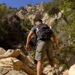
Love this hike!! This only my second time taking the trip. It's been a good year or two since the last time I went and it was a much better experience because the weather (temperature) was perfect! While the out and back trial isn't extremely long, a little over 2.5 miles round trip, I would say it's a "hard" trail difficulty wise. It's a gradual incline the whole way up to the hot springs with very few moments it flattens out without an incline of elevation. Additionally, there are a lot of rocks on the trail, so you have to have good footing or take some walking sticks. My daughter who is 13 went with me and she did great. However, if it had been hotter she would not have enjoyed it. She took a few short rests on the way up, but almost ran the trail going back down! When we got to the hot springs it was pretty crowded, not excessively where we couldn't find a spot, but a lot of people were there and the traffic was a consistent flow. There's quite a mix of the crowd with some college age students, families, couples and solo hikers. Everyone is friendly and seemed to be respectful of each other. One group had a speaker playing music, but it wasn't obnoxious and didn't bother me. Also, remember, if you take children i believe clothing is optional, so they may get an eye full. Haha The upper pools are extremely hot and then as you go down the temperature is more tolerable to submerse your whole body. My daughter only wanted to put her feet in and even that it was still a little too hot for her at times. Just be cautious. We packed a lunch and sat there soaking for a little while. Even thought daughter didn't get in the whole way she still really enjoyed herself and said the hike was definitely worth it! A couple more mentions, there are a lot of dogs on this trail as they're allowed and even off leash. Parking is VERY limited. If you have more of an SUV type vehicle I suggest driving that. There is a side where you have to drive over a curb to park along the side of the road and we saw one car stuck! Get there early if you can, otherwise you might have to walk a little ways to the trail head. It was a great mother-daughter date and I'll be back again.

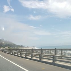
Beautiful hike! more on the moderate side due to the gradual incline all of the way up, crossing over a few creeks, and some areas are rocky! Took about 40-45 min to reach the hot springs. The cloud and fog cover made the hike enjoyable! The reward at the top (the hot springs) is SO WORTH IT! One thing to note - PARKING! There is almost NO PARKING HERE! Either you have to come really early in the morning (5-6am) to snag one of the 6 parking spots or you have to Uber/Lyft. Please don't rush your car being towed. If you really want to enjoy the hike and the hot springs, highly recommend going very very early in the morning (between 5-7am) Be sure to bring water shoes, towels, bathing suit, add and a change of clothes.


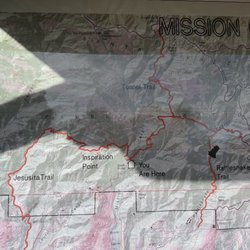
My husband and I recently went to this trail when we were visiting SB! We've been on many different hikes and this one was definitely one of the harder ones. I say this mainly because of the incline throughout the entire way there as well as different walking terrain such as walking over rocks big and small, wet slippery dirt and rocks, and some narrow path at times. Overall, the hike was rewarding with the end hot springs. If you are not a local, I recommend bringing a map or having an idea of how to get to the springs. There was no service the entire hike. There were a few times where my husband and I thought the path continued one way but we were wrong. Luckily we ran into another couple who were also confused and also ran into some locals who told us where to go, but they definitely reassured us that they made the same mistake too. I'd recommend this hike to anyone in for a 2.5 mile hike round trip with an incline one way and a rewarding hot spring at the end. I recommend going at 8 AM, parking is VERY limited and you may end up waiting in your car for a spot to open if you don't come early enough.


AMAZING!!!! This is absolutely the best hike ever and so worth it! It's around a 3.5 + hike and there are a lot of rocks. Make sure you are wearing comfortable shoes. It is easy to get lost if you are new because once you get closer to the hot springs, you will need to cross over with a ton of rocks. It's easy to just keep going up and following the trail. We followed some people and that was helpful. I recommend downloading the app; AllTrails app as it was helpful tracking the route. Hot springs: Amazing!!! It gets hotter as you climb up. Be careful because you can get easily hurt by stepping on the wrong rocks or slipping on a rock. Other than that, you can just relax Parking: Horrible if you do not get there early enough to get the parking located in the front of the entrance! There had to be around 9-10 parking spots. You can park a few miles down in the neighborhood but be careful because there was a sign on the trail saying that parking tickets were being given out. I encourage you to arrive early! We drove around for 10 mins until we actually got a parking spot. THIS IS A MUST IF YOU ARE IN THE AREA!

A beautiful trail in the hills above Santa Barbara. I hiked this trail while on vacation with my family in December. The trail is nice with a moderate incline the whole way up. The entire loop is around 4 miles. The hot springs are about halfway through the hike. You will know you are getting close to the hot springs when you can smell the sulfur. The smell is very strong. The hot springs itself are nice to see and visit, but are usually very crowded, so I'd recommend just stopping for a little while, but keep on going with your hike. After the hot springs, you will continue to climb until you reach a beautiful lookout at the top. From here, you can see the city of Santa Barbara and the ocean down below. Parking can be challenging as there is no designated parking lot or anything. You have to find parking around the streets. However, I would recommend this trail as it is a short, family friendly hike. They even allow dogs on this trail.

This trail is kept authentic. Nothing to make it any easier, no port a potty, no steps etc, and that's the way I like it. The terrain was very difficult at times such as when you have to navigate among big rocks, and focus on not to slip on loose dirt etc. once at the top you will end up at the hot springs- actually you can smell the sulfur before you arrive. The water was HOT!!!! Omg- really hot. Remember to pack snack and cold water to enjoy while soaking in the "boiling" water. The hike was easy to descend! I saw families with young kids on the trail and few dogs.

This is one hike everyone should try. The hike takes you on a loop. Whichever direction you choose, you'll still be able to find your way to the hot springs. Once you catch the smell of sulfur, you'll know you're close by. It is a therapeutic experience. It is a moderate hike, but one that's worth the energy to then relax on the spring of your choosing; depending how warm you like your water . More people should try visiting these hot springs. Personally, it it was what I needed mentally and physically. I hope that whoever finds their way here, also finds it mentally and physically beneficial.

This place was insane!!! I had no idea there was a hot spring so close to me, but it was such a unique hike and experience that made for a fun weekend trip! In theory, the hike itself is relatively short (~3 miles round trip) but it is STEEP! Definitely recommend wearing proper shoes with good grip for this hike. Halfway through, I was pretty burnt out and was wondering if the hot springs would even be worth it. IT. WAS. While there were a decent number of people around, the hot springs had individual pools for people to be separated in. I figured the hot springs would've been a nice temperature to cool off in after the hike, but it was almost like a jacuzzi in terms of temperature! Quick word of warning - for those with silver jewelry, the hot springs have sulfur in the water and WILL react with your jewelry and turn them into a rusty orange shade. I found out the hard way, but you just have to brush them with toothpaste and they were back to being good as new!

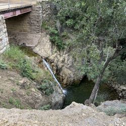
Got information from trail walking group. We then started off from Los Angels on a Tuesday afternoon. It took more than two hours drive due to LA traffic. Following the GPS, we arrived at 4 pm. We followed the trail direction to walk uphill for about 10 mins to see a sign saying we have 0.7 miles more to hot spring. We kept walking uphill. While waking up, there were pipelines and we could feel they were hot but the water through those rocks was cold. We did believe there was somewhere hot uphill. As it's not daylight saving time, it got dark so quick. When we were up after almost an hour, we saw a left and right direction. While we couldn't decide which direction and it was getting dark, we gave up and walked back down for safety reason. Coming back down was kind of slippery due to the steep and dusty road. we had a strong flashlight to help. It was good experience even we had not found the hot spring. We will try again next time.

Hidden away in the Montecito mountains is this beautiful hot spring!! It is around a 3 mile hike round trip. To the hotsprings is mostly up hill but going down is all downhill! When you get to the hot spring, the highest one is the hottest and the lower you go the cooler it gets! Perfect place to bring a face mask and relax.

2 months ago
Amazing hike! It is one of the easier hikes to access to the relaxing hot springs. Watch out for poison ivy! Totally worth it! Thank you to the BW Staff for providing me helpful tips. 10/10 will return. read more


5 months ago
1 year ago
Love this hike!! This only my second time taking the trip. It's been a good year or two since the last time I went and it was a much better experience because the weather (temperature) was perfect! While the out and back trial isn't extremely long, a little over 2.5 miles round trip, I would say it's a "hard" trail difficulty wise. It's a gradual incline the whole way up to the hot springs with very few moments it flattens out without an incline of elevation. Additionally, there are a lot of rocks on the trail, so you have to have good footing or take some walking sticks. My daughter who is 13 went with me and she did great. However, if it had been hotter she would not have enjoyed it. She took a few short rests on the way up, but almost ran the trail going back down! When we got to the hot springs it was pretty crowded, not excessively where we couldn't find a spot, but a lot of people were there and the traffic was a consistent flow. There's quite a mix of the crowd with some college age students, families, couples and solo hikers. Everyone is friendly and seemed to be respectful of each other. One group had a speaker playing music, but it wasn't obnoxious and didn't bother me. Also, remember, if you take children i believe clothing is optional, so they may get an eye full. Haha The upper pools are extremely hot and then as you go down the temperature is more tolerable to submerse your whole body. My daughter only wanted to put her feet in and even that it was still a little too hot for her at times. Just be cautious. We packed a lunch and sat there soaking for a little while. Even thought daughter didn't get in the whole way she still really enjoyed herself and said the hike was definitely worth it! A couple more mentions, there are a lot of dogs on this trail as they're allowed and even off leash. Parking is VERY limited. If you have more of an SUV type vehicle I suggest driving that. There is a side where you have to drive over a curb to park along the side of the road and we saw one car stuck! Get there early if you can, otherwise you might have to walk a little ways to the trail head. It was a great mother-daughter date and I'll be back again. read more


Beautiful hike! more on the moderate side due to the gradual incline all of the way up, crossing over a few creeks, and some areas are rocky! Took about 40-45 min to reach the hot springs. The cloud and fog cover made the hike enjoyable! The reward at the top (the hot springs) is SO WORTH IT! One thing to note - PARKING! There is almost NO PARKING HERE! Either you have to come really early in the morning (5-6am) to snag one of the 6 parking spots or you have to Uber/Lyft. Please don't rush your car being towed. If you really want to enjoy the hike and the hot springs, highly recommend going very very early in the morning (between 5-7am) Be sure to bring water shoes, towels, bathing suit, add and a change of clothes. read more


1 year ago
Love this hike, so worth the hike up but not the easiest. Took our Frenchie, trail is also dog friendly. Hot springs were mostly super hot with some shaded pools that were cooler. read more


1 year ago
My husband and I recently went to this trail when we were visiting SB! We've been on many different hikes and this one was definitely one of the harder ones. I say this mainly because of the incline throughout the entire way there as well as different walking terrain such as walking over rocks big and small, wet slippery dirt and rocks, and some narrow path at times. Overall, the hike was rewarding with the end hot springs. If you are not a local, I recommend bringing a map or having an idea of how to get to the springs. There was no service the entire hike. There were a few times where my husband and I thought the path continued one way but we were wrong. Luckily we ran into another couple who were also confused and also ran into some locals who told us where to go, but they definitely reassured us that they made the same mistake too. I'd recommend this hike to anyone in for a 2.5 mile hike round trip with an incline one way and a rewarding hot spring at the end. I recommend going at 8 AM, parking is VERY limited and you may end up waiting in your car for a spot to open if you don't come early enough. read more


4 years ago
This hot springs trail hike is so nice!! I definitely recommend it for a beginner hiker or children. I would recommend to park around the little bend before you go up to the hike. There is designated parking areas for it. Take a water bottle and pick up after yourself!!! read more

AMAZING!!!! This is absolutely the best hike ever and so worth it! It's around a 3.5 + hike and there are a lot of rocks. Make sure you are wearing comfortable shoes. It is easy to get lost if you are new because once you get closer to the hot springs, you will need to cross over with a ton of rocks. It's easy to just keep going up and following the trail. We followed some people and that was helpful. I recommend downloading the app; AllTrails app as it was helpful tracking the route. Hot springs: Amazing!!! It gets hotter as you climb up. Be careful because you can get easily hurt by stepping on the wrong rocks or slipping on a rock. Other than that, you can just relax Parking: Horrible if you do not get there early enough to get the parking located in the front of the entrance! There had to be around 9-10 parking spots. You can park a few miles down in the neighborhood but be careful because there was a sign on the trail saying that parking tickets were being given out. I encourage you to arrive early! We drove around for 10 mins until we actually got a parking spot. THIS IS A MUST IF YOU ARE IN THE AREA! read more


A beautiful trail in the hills above Santa Barbara. I hiked this trail while on vacation with my family in December. The trail is nice with a moderate incline the whole way up. The entire loop is around 4 miles. The hot springs are about halfway through the hike. You will know you are getting close to the hot springs when you can smell the sulfur. The smell is very strong. The hot springs itself are nice to see and visit, but are usually very crowded, so I'd recommend just stopping for a little while, but keep on going with your hike. After the hot springs, you will continue to climb until you reach a beautiful lookout at the top. From here, you can see the city of Santa Barbara and the ocean down below. Parking can be challenging as there is no designated parking lot or anything. You have to find parking around the streets. However, I would recommend this trail as it is a short, family friendly hike. They even allow dogs on this trail. read more


This trail is kept authentic. Nothing to make it any easier, no port a potty, no steps etc, and that's the way I like it. The terrain was very difficult at times such as when you have to navigate among big rocks, and focus on not to slip on loose dirt etc. once at the top you will end up at the hot springs- actually you can smell the sulfur before you arrive. The water was HOT!!!! Omg- really hot. Remember to pack snack and cold water to enjoy while soaking in the "boiling" water. The hike was easy to descend! I saw families with young kids on the trail and few dogs. read more


This is one hike everyone should try. The hike takes you on a loop. Whichever direction you choose, you'll still be able to find your way to the hot springs. Once you catch the smell of sulfur, you'll know you're close by. It is a therapeutic experience. It is a moderate hike, but one that's worth the energy to then relax on the spring of your choosing; depending how warm you like your water . More people should try visiting these hot springs. Personally, it it was what I needed mentally and physically. I hope that whoever finds their way here, also finds it mentally and physically beneficial. read more

2 years ago
1 year ago
5 years ago
This place was insane!!! I had no idea there was a hot spring so close to me, but it was such a unique hike and experience that made for a fun weekend trip! In theory, the hike itself is relatively short (~3 miles round trip) but it is STEEP! Definitely recommend wearing proper shoes with good grip for this hike. Halfway through, I was pretty burnt out and was wondering if the hot springs would even be worth it. IT. WAS. While there were a decent number of people around, the hot springs had individual pools for people to be separated in. I figured the hot springs would've been a nice temperature to cool off in after the hike, but it was almost like a jacuzzi in terms of temperature! Quick word of warning - for those with silver jewelry, the hot springs have sulfur in the water and WILL react with your jewelry and turn them into a rusty orange shade. I found out the hard way, but you just have to brush them with toothpaste and they were back to being good as new! read more


 jewelry after a dip in the sulfur water - Hiking Near Me - Montecito, California")
5 years ago
Got information from trail walking group. We then started off from Los Angels on a Tuesday afternoon. It took more than two hours drive due to LA traffic. Following the GPS, we arrived at 4 pm. We followed the trail direction to walk uphill for about 10 mins to see a sign saying we have 0.7 miles more to hot spring. We kept walking uphill. While waking up, there were pipelines and we could feel they were hot but the water through those rocks was cold. We did believe there was somewhere hot uphill. As it's not daylight saving time, it got dark so quick. When we were up after almost an hour, we saw a left and right direction. While we couldn't decide which direction and it was getting dark, we gave up and walked back down for safety reason. Coming back down was kind of slippery due to the steep and dusty road. we had a strong flashlight to help. It was good experience even we had not found the hot spring. We will try again next time. read more


6 years ago
Hidden away in the Montecito mountains is this beautiful hot spring!! It is around a 3 mile hike round trip. To the hotsprings is mostly up hill but going down is all downhill! When you get to the hot spring, the highest one is the hottest and the lower you go the cooler it gets! Perfect place to bring a face mask and relax. read more


2 years ago
2 years ago
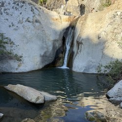
One of Santa Barbara's true hidden wonders! I navigated this trail yesterday and it was easier than I had anticipated. We took the "long route" up, from the San Ysidro trailhead. The distance to the top was 2.9 miles and around 1300 feet of elevation gain per my Strava app. After hearing from other hikers, we decided to take the "short route" back down which was closer to a mile - but then walked for over a mile up the main road back to our vehicles. The trail was very well maintained and was just gorgeous the entire time. There were areas toward the base which were littered with horse/dog feces so be cautious where you step. I also saw patches of poison oak but it was pretty well cleared off of the trail itself. The San Ysidro trailhead ventures off into a handful of different hiking trails. I know that the most advanced of them was the route to East Camino Cielo which takes you up to an elevation of over 3000 feet and adds an extra 3.4 miles. The hot springs were breathtaking and very clean. There were about 10 different pools in a row, and each were on different levels which made for a more private experience. The higher the pool, the warmer the water temperature. The pool we soaked in was the third from the bottommost one and felt like a bathtub. While the pools are all ages (there were children and adults hanging out), we did see a handful of nudists so keep that in mind. I'd also recommend starting your hike before 8am as the pools will become rather crowded later in the day. Definitely will hike up here again. read more


5 years ago
5 years ago
3 years ago
if you plan to come here for hot springs, then don't go ,just waste time and the water there so dirty and crowded,i will take you a hour to hiking to hot springs.people bring dogs and let in stay in hot springs with people around,the spring water tub is very small.People came and ruined that place.Even for hiking ,the trail is narrow and crowded not safe and not worthy to go there.if you go there make sure bring water. read more

4 years ago
5 years ago
4 years ago
4 years ago
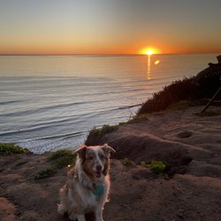
My favorite hike in Cali. The hike is beautiful and overlooks the ocean. A hike with a dreamy destination. The hot-spring pools go from hottest to warmest (the top being the hottest.) We usually bring fruit, snacks, and lots of water. Hang out in the pools, rub some of the mud that sits at the bottom of the pools on your face and body. After a couple hours of hanging out we head back at around sunset and warch the sun go down as you are heading back to your car. Parking is limited, please be respectful of the neighborhood. All of the tires have to be OFF the pavement. We saw law enforcement writing out tickets. If you find dirt parking make sure it is NOT on private property I cant stress this enough. These people pay hundreds of thousands of dollars/ even millions to live here in tranquility, just to have people park on their property, leave trash behind, and be disrespectful. Not everyone is like this, No, but I do see loads of people parking on the pavement & the occasional person who litters or isn't respectful of their surrounds. Enjoy this place but treat it like your home so that we can all benefit from visiting these beautiful hot springs. read more


4 years ago
4 years ago
4 years ago
5 years ago
5 years ago
5 years ago
5 years ago
4 years ago
4 years ago
3 years ago
Page 1 of 2
More info about Hot Spring Trail
1202 E Mountain Dr
Montecito, CA 93108
Directions
Hours
Outdoor Amenities
Hot Spring Trail Reviews in Other Languages
Ask the Community - Hot Spring Trail
Where do you change after the dip? How bad is the sulfur smell? Can kids tolerate it?
Where do you change? Anywhere you like near the spring. It is clothing optional- you don't even need a bathing suit if you don't want to wear one!
Review Highlights - Hot Spring Trail
You might also consider


Why does Yelp recommend reviews?
1 review that is not currently recommended
The reviews below are not factored into the business's overall star rating.
3 years ago
Hot Spring Trail - hiking - Updated June 2026
Best of Montecito
People found Hot Spring Trail by searching for…
Things to Do in Montecito, California
Scenic View in Montecito, California
Hiking Trails in Montecito, California
Attractions in Montecito, California
Parks in Montecito, California
Off Road Trails in Montecito, California
Fun Things to Do at Night in Montecito, California
Star Gazing in Montecito, California
Sunset View in Montecito, California
Beautiful Views in Montecito, California
Walking Trails in Montecito, California
Running Trails in Montecito, California
Hot Springs in Montecito, California
Easy Hikes in Montecito, California
Night Hike in Montecito, California
Hiking Trails Kid Friendly in Montecito, California
Trails in Montecito, California
Natural Springs in Montecito, California
Creeks in Montecito, California
Weird Attractions in Montecito, California
Trending Searches in Montecito, CA
Bait And Tackle Shop near Hot Spring Trail
Black Owned Nail Salons near Hot Spring Trail
Boat Rental near Hot Spring Trail
Cliff Jumping near Hot Spring Trail
Day Trips near Hot Spring Trail
Dog Friendly Trails near Hot Spring Trail
Fishing Spots near Hot Spring Trail
Jet Ski Rental near Hot Spring Trail
Kayak Rental near Hot Spring Trail
Lakes & Ponds near Hot Spring Trail
Outdoor Activities near Hot Spring Trail
Pick Your Own Farms near Hot Spring Trail
Places To Walk Around near Hot Spring Trail
Public Shower near Hot Spring Trail
River Swimming near Hot Spring Trail
Rock Quarry near Hot Spring Trail
Scenic Night View near Hot Spring Trail
Scenic Overlook near Hot Spring Trail
Secluded Spots near Hot Spring Trail
Soccer Store near Hot Spring Trail
Splash Pad near Hot Spring Trail
Strawberry Picking near Hot Spring Trail
Sunrise View near Hot Spring Trail
Swimming Holes near Hot Spring Trail
Swimming Lakes near Hot Spring Trail
Swimming Pools near Hot Spring Trail
Watch Sunset near Hot Spring Trail
Browse Articles
Browse Nearby
BEST of Montecito, California Restaurants near Hot Spring Trail
BEST of Montecito, California Coffee near Hot Spring Trail
BEST of Montecito, California Things to Do near Hot Spring Trail
BEST of Montecito, California Parks near Hot Spring Trail
BEST of Montecito, California Walking Trails near Hot Spring Trail
BEST of Montecito, California Breakfast near Hot Spring Trail
BEST of Montecito, California Hot Springs near Hot Spring Trail
BEST of Montecito, California Campgrounds near Hot Spring Trail
BEST of Montecito, California Sightseeing near Hot Spring Trail
Browse Brands
Related Searches in Montecito, CA
Affordable Kayak Rental Services in Montecito, California
Best Fishing Locations and Guides in Montecito, California
Best Places for Horseback Riding in Montecito, California
Best Waterfalls and Swimming Holes in Montecito, California
Check Out Off Road Trails in Montecito, California
Discover Dog Friendly Trails to Explore in Montecito, California
Discover Kid Friendly Hiking Trails in Montecito, California
Discover Scenic Waterfall Spots in Montecito, California
Discover a Hiking Trail in Montecito, California
Discover the Best Night Hike Trails in Montecito, California
Discover the Best Running Track in Montecito, California
Dog-Friendly Hikes With Dogs in Montecito, California
Enjoy Camping Adventures Around Montecito, California
Enjoy Exciting Mountain Biking Adventures in Montecito, California
Enjoy Kayaking Adventures in Montecito, California
Enjoy Tent Camping Spots Around Montecito, California
Enjoy a Beautiful Waterfall Hike in Montecito, California
Enjoy the Best Picnic Spots and Ideas in Montecito, California
Enjoy the Best Walking Path in Montecito, California
Enjoy the Best Walking Trails in Montecito, California
Exciting Cliff Jumping Spots in Montecito, California
Explore Beautiful Parks and Green Spaces in Montecito, California
Explore Easy Hikes Perfect for All in Montecito, California
Explore Fun Activities to Do in Montecito, California
Explore Popular Campgrounds Near Montecito, California
Explore Top Dog Parks in Montecito, California Near You
Explore the Best Beach Spots in Montecito, California
Explore the Best Swimming Holes Around Montecito, California
Explore the Best Trail Options in Montecito, California
Family Friendly Hiking With Kids in Montecito, California
Find Beautiful Views in Montecito, California
Find Popular Ziplining Spots Around Montecito, California
Find the Best Parks for Picnics in Montecito, California
Find the Best Scenic View Locations in Montecito, California
Great Places to Walk in Montecito, California
Hiking Trails With Waterfalls in Montecito, California
Off Leash Dog Hiking Trails in Montecito, California
Plan a Scenic Drive Route Near Montecito, California
Popular Outdoor Activities to Try in Montecito, California
Popular Picnic Spots to Visit in Montecito, California
Popular Things to Do in Montecito, California
Safe River Swimming Areas in Montecito, California
Safe and Fun Parks for Kids in Montecito, California
Top Climbing Spots and Gyms in Montecito, California
Top Paddleboarding Activities in Montecito, California
Top Places for Snorkeling in Montecito, California
Top Running Trails to Explore in Montecito, California
Top Swimming Spots and Pools in Montecito, California