San Ysidro Falls Trail Photos


You might also consider
More like San Ysidro Falls Trail
Recommended Reviews - San Ysidro Falls Trail
Start your review...

Reviews With Photos

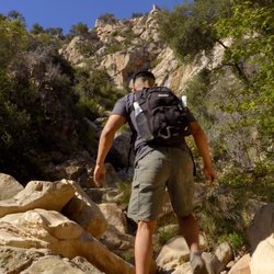
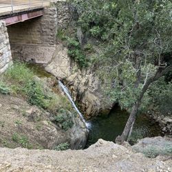
A moderate level hike that takes about an hour round trip to the falls. After a rainy season, the falls are actually there and parts of the hike are blanketed in a lush green blanket. Wear long pants since there is poison oak everywhere. There is also great rock climbing about midway up the hike. You need to park in a residential area and walk in. Just looking at the houses in that area is fun in itself. There aren't any bathrooms or potable water at the trailhead. A good hike to do with kids or if you only have an hour or two.


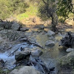
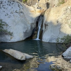
I always like to check out a new trail while on vacation. With the rainy winter we've had in California, a falls hike seemed like the perfect option during my long weekend in Santa Barbara. Now (or soon) is the time to go, since the falls are flowing and there are a lot of small pools and a smaller waterfall to enjoy. First off, logistics! The trail head is not as hard to find as I thought it would be. You will see cars parked alongside of the road (at least on a weekend morning) and a sign simply marked "Trail" on the right hand side. There is a narrow path you follow that runs along side private property but there are several markers telling you where to stick to the trail. After going around a gate and walking up a wider fire road, you will have the creek to your left and start heading up hill. There are a few junctions but for the most part follow the the trail to the right and up. At one point it seemed wrong to head to the right because it briefly led away from the creek, but that's short lived and you will connect back with it soon enough. The trail itself is short, but scenic and well shaded. Don't let the tree canopy fool you though-it gets warm out here and I went through about 40 ounces of water in a 2.5 hour hike. Once you arrive at a smaller waterfall, you can rest and enjoy the small pool and for families with children that might just be enough. However, for the 80 foot fall at the back of the canyon, you will see a narrow trail that curves up to the right-follow that and in less than half a mile you will be at the larger falls. This is a well traveled trail and later in the morning it seemed to get more crowded. I was glad we started our hike around 10 a.m. because we had the falls nearly to ourselves. By the time we were headed down, we passed several groups heading up. I had worn regular running sneakers but actually could have used something with a good grip-there are a lot of loose rocks on the trail so be careful of your footing. The trail was moderate for experienced hikers but the elevation gain sneaks up on you-you are basically going up hill the first half of the hike. I believe the entire out and back hike is 4 miles or less and the 2.5 hour journey included some time relaxing at the falls and plenty of photos stops. So glad I made it over here and perhaps on another trip I would do some more research and try out some of the longer trails. There were definitely connections to other hiking options and one that I believe even leads to Los Padres National Forest. What a nice little free and wonderful find.

Hiked this trail last week. Still one of my favorite hikes but quite muddy right now in the beginning from all the rain. The last bit of the trail before you reach the waterfall is washed out so if you want to get up close to the waterfall you have to hike in the creek bed and climb/jump some rocks.

We had a nice hike up the main San Ysidro Falls Trail - it can get hot here, so this is a good choice to maximize shade. We only went about 1.5 miles up. Unfortunately, we didn't get sweeping views of Santa Barbera and the ocean below that I was hoping for - the trail winds behind some of the mountains. However, you get a variety of vegetation (cacti, forests, grassy areas) and the path follows running water so you get some little falls. There are some nice views of the other side of the mountain, some exposed rock that look like fun for scrambling/climbing. FYI, the first half quarter mile or so of the trail goes through some residential areas before it gets to the more remote areas!

Ahhh!! Perfect time to do this hike and see the waterfall is RIGHT NOW! San Ysidro Falls is a beautiful hike with a gorgeous and totally-worth-it waterfall view at the end. Apparently there are two locations to start the hike since I did read reviews about the 9 mile roundtrip one but our hike was only 3.3 miles roundtrip. It definitely felt like longer since it was mostly uphill the entire time. Took us about 2 hours total. We went around 10 am on a Sunday morning. Parking wasn't hard to find at all and the trail leading up to the waterfall was relatively easy to find as well. Stick to the trails that keep going up and there were plenty of friendly people we encountered on the way who were able to point us in the right direction when we were uncertain. Keep in mind that if you plan on walking around in the water or taking pictures underneath the waterfall it might be a good idea to bring sandals or another change of shoes since we decided to walk around in the water and ended up getting our shoes wet.

First of all June 2017 no water at the tall fall at the end of the hike. Still a nice hike 2 things I feel other reviews didn't accurately portray: Difficulty - I'm in pretty good shape and was expecting an easy 1-2 mile hike. Definitely more moderate and four miles to the last big waterfall (or waterless fall in June) and much of it uphill. Scenery- much prettier than I expected. Lots of greenery and wild flowers. Tons of small little water holes to play in. Watch out for bugs, almost all shaded. Overall I recommend checking it out. Gorgeous houses at the beginning of the trail.

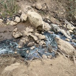
I am extremely hesitant to say the San Ysidro trail is "open", however, I was able to make it all the way to the dried up falls. It is one of the few hikes besides Rattlesnake Canyon that is shaded. However, I highly recommend only skilled or experienced hikers go. I was able to witness the damage caused by the Montecito mudslides and then Thomas Fire first hand from this trail. The damage was not only devastating to the families and homes but also to the surrounding trails and nature. What use to be a creek is now a widened, carved out river. Many trees are toppled and burnt while the trail is unsteady and has given way to the cliffs. There are multiple sections of the trail that are best traveled along the riverbed versus using the trail along the riverside. Multiple hikers, including myself, have laid stone markers to distinguish the path, however, many confusing and unsafe areas remain. A hiking post from Santabarbara.com has a detailed description of the trail, yet towards the end it does not help much due to the changes. San Ysidro Falls trail is spectacular yet it is sad to see so much damage. Hopefully volunteers will fix it up with time since it is a diamond in the rough!

The 4.5 mile climb is not easy but the view at the top makes up for it. The second half of the climb is mostly in the sun but the shaded spots are nice places to take short breaks. There are some loose spots on the ground which made me and my friends slip a little bit on the way down. It's very dry up there so be sure to hydrate and wear shoes that can get dirty! 7/10 (The 5 star system on Yelp sucks)

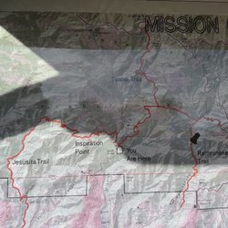
The trailhead was a bit hard to find at first so look up a map of the area to make sure you know exactly where you need to be. It's located on E Mountain drive to the left of Park Lane. We got lost driving around Montecito looking for it for about 20 minutes and there's poor/no cell reception to get a gps reading up there. Getting lost wasn't so bad considering the estates in the area were breath taking. The locals on the streets were very friendly and gave us directions. Listen to the directions carefully because there are many trails in the area and you might end up following the wrong trail! Do your research before you get there and make sure to print out a map. I found this website useful: http://www.santabarbarahikes.com/hikes/frontcountry/directions/index.shtml?san_ysidro The San Ysidro Falls trail follows paved road for a slight part of the trail's beginning and becomes quite steep at many points in the trail. The path is well carved by all of the previous visitors so it's easy to follow without losing the tracks. There is a lot of tree cover and shade which is a blessing because you will definitely break a sweat going up. At later points in the trail closer to the waterfall you'll get to extremely large high steps so if you're not into making a climb then this isn't the trail for you. It isn't that difficult though unless you're just plain lazy. The trail does go up pretty high in the mountains so it's slightly tiring but is definitely doable with a few rest stops. Most people of average physical fitness should be able to do it with no problems. The trail is approximately 2 hours upwards and 1 hour to go back down if your ending destination is the waterfall. Make sure to bring a lot of water and a face towel to wipe sweat with. I hiked with one other person and we each carried a backpack of 4 water bottles which we ended up finishing 6 of the 8 bottles. There are some flying insects like ladybugs and butterflys but all of the insects are pretty much harmless. If you don't like them flying near you then make sure to put on some insect repellent. The waterfall is beautiful and definitely worth the climb. The coloring of the waterfall is much more spectacular in person than it is in the pictures. I walked into the pool of the waterfall and it was amazing. The water was pretty cold but you get used to it. There's plenty of areas and large rocks to sit on and enjoy it.


All Trails rates this hike as moderate by I say it's more towards hard. It is a steady steep incline for 3+ miles. All trails also says it's only 3.5 miles, that is one way! So your looking at 7 miles round trip. It's rocky but with shade the first 2 miles. After that bye bye shade and hello dry and dusty trail. You will want to wear hiking boots has it's very easy to loose gripping on the rocks and roll your ankle. I called it quits at 3 miles and went back down the trail. I was exhausted from the steady climb. I am not the most in shape person right now but I am fairly active. I just hiked 5 miles last week too. So unless you are in decent shape, be prepared to not make it all the way to the top. Bring plenty of water. As someone else said, walking through the private property portion until hitting the split off of the McMenemy trail is filled with dog poop and abandoned dog poop bags. It seems people don't take their dogs on the San Ysidro as I no longer says dog poop or bags unless they just kick it off the cliff side. On my way back down I saw a Gardner snake just off of the trail path. We started at 10:45 am and arrived back at the car at 1:42 pm. read more


3 years ago
A moderate level hike that takes about an hour round trip to the falls. After a rainy season, the falls are actually there and parts of the hike are blanketed in a lush green blanket. Wear long pants since there is poison oak everywhere. There is also great rock climbing about midway up the hike. You need to park in a residential area and walk in. Just looking at the houses in that area is fun in itself. There aren't any bathrooms or potable water at the trailhead. A good hike to do with kids or if you only have an hour or two. read more


6 years ago
5 years ago
Cute hike!! Hard to find parking, but the drive there and views from the hike are gorgeous. Montecito is a beautiful area! read more


9 years ago
I always like to check out a new trail while on vacation. With the rainy winter we've had in California, a falls hike seemed like the perfect option during my long weekend in Santa Barbara. Now (or soon) is the time to go, since the falls are flowing and there are a lot of small pools and a smaller waterfall to enjoy. First off, logistics! The trail head is not as hard to find as I thought it would be. You will see cars parked alongside of the road (at least on a weekend morning) and a sign simply marked "Trail" on the right hand side. There is a narrow path you follow that runs along side private property but there are several markers telling you where to stick to the trail. After going around a gate and walking up a wider fire road, you will have the creek to your left and start heading up hill. There are a few junctions but for the most part follow the the trail to the right and up. At one point it seemed wrong to head to the right because it briefly led away from the creek, but that's short lived and you will connect back with it soon enough. The trail itself is short, but scenic and well shaded. Don't let the tree canopy fool you though-it gets warm out here and I went through about 40 ounces of water in a 2.5 hour hike. Once you arrive at a smaller waterfall, you can rest and enjoy the small pool and for families with children that might just be enough. However, for the 80 foot fall at the back of the canyon, you will see a narrow trail that curves up to the right-follow that and in less than half a mile you will be at the larger falls. This is a well traveled trail and later in the morning it seemed to get more crowded. I was glad we started our hike around 10 a.m. because we had the falls nearly to ourselves. By the time we were headed down, we passed several groups heading up. I had worn regular running sneakers but actually could have used something with a good grip-there are a lot of loose rocks on the trail so be careful of your footing. The trail was moderate for experienced hikers but the elevation gain sneaks up on you-you are basically going up hill the first half of the hike. I believe the entire out and back hike is 4 miles or less and the 2.5 hour journey included some time relaxing at the falls and plenty of photos stops. So glad I made it over here and perhaps on another trip I would do some more research and try out some of the longer trails. There were definitely connections to other hiking options and one that I believe even leads to Los Padres National Forest. What a nice little free and wonderful find. read more


6 years ago
Hiked this trail last week. Still one of my favorite hikes but quite muddy right now in the beginning from all the rain. The last bit of the trail before you reach the waterfall is washed out so if you want to get up close to the waterfall you have to hike in the creek bed and climb/jump some rocks. read more


We had a nice hike up the main San Ysidro Falls Trail - it can get hot here, so this is a good choice to maximize shade. We only went about 1.5 miles up. Unfortunately, we didn't get sweeping views of Santa Barbera and the ocean below that I was hoping for - the trail winds behind some of the mountains. However, you get a variety of vegetation (cacti, forests, grassy areas) and the path follows running water so you get some little falls. There are some nice views of the other side of the mountain, some exposed rock that look like fun for scrambling/climbing. FYI, the first half quarter mile or so of the trail goes through some residential areas before it gets to the more remote areas! read more

7 years ago
Ahhh!! Perfect time to do this hike and see the waterfall is RIGHT NOW! San Ysidro Falls is a beautiful hike with a gorgeous and totally-worth-it waterfall view at the end. Apparently there are two locations to start the hike since I did read reviews about the 9 mile roundtrip one but our hike was only 3.3 miles roundtrip. It definitely felt like longer since it was mostly uphill the entire time. Took us about 2 hours total. We went around 10 am on a Sunday morning. Parking wasn't hard to find at all and the trail leading up to the waterfall was relatively easy to find as well. Stick to the trails that keep going up and there were plenty of friendly people we encountered on the way who were able to point us in the right direction when we were uncertain. Keep in mind that if you plan on walking around in the water or taking pictures underneath the waterfall it might be a good idea to bring sandals or another change of shoes since we decided to walk around in the water and ended up getting our shoes wet. read more


9 years ago
First of all June 2017 no water at the tall fall at the end of the hike. Still a nice hike 2 things I feel other reviews didn't accurately portray: Difficulty - I'm in pretty good shape and was expecting an easy 1-2 mile hike. Definitely more moderate and four miles to the last big waterfall (or waterless fall in June) and much of it uphill. Scenery- much prettier than I expected. Lots of greenery and wild flowers. Tons of small little water holes to play in. Watch out for bugs, almost all shaded. Overall I recommend checking it out. Gorgeous houses at the beginning of the trail. read more


I am extremely hesitant to say the San Ysidro trail is "open", however, I was able to make it all the way to the dried up falls. It is one of the few hikes besides Rattlesnake Canyon that is shaded. However, I highly recommend only skilled or experienced hikers go. I was able to witness the damage caused by the Montecito mudslides and then Thomas Fire first hand from this trail. The damage was not only devastating to the families and homes but also to the surrounding trails and nature. What use to be a creek is now a widened, carved out river. Many trees are toppled and burnt while the trail is unsteady and has given way to the cliffs. There are multiple sections of the trail that are best traveled along the riverbed versus using the trail along the riverside. Multiple hikers, including myself, have laid stone markers to distinguish the path, however, many confusing and unsafe areas remain. A hiking post from Santabarbara.com has a detailed description of the trail, yet towards the end it does not help much due to the changes. San Ysidro Falls trail is spectacular yet it is sad to see so much damage. Hopefully volunteers will fix it up with time since it is a diamond in the rough! read more


12 years ago
The 4.5 mile climb is not easy but the view at the top makes up for it. The second half of the climb is mostly in the sun but the shaded spots are nice places to take short breaks. There are some loose spots on the ground which made me and my friends slip a little bit on the way down. It's very dry up there so be sure to hydrate and wear shoes that can get dirty! 7/10 (The 5 star system on Yelp sucks) read more


15 years ago
The trailhead was a bit hard to find at first so look up a map of the area to make sure you know exactly where you need to be. It's located on E Mountain drive to the left of Park Lane. We got lost driving around Montecito looking for it for about 20 minutes and there's poor/no cell reception to get a gps reading up there. Getting lost wasn't so bad considering the estates in the area were breath taking. The locals on the streets were very friendly and gave us directions. Listen to the directions carefully because there are many trails in the area and you might end up following the wrong trail! Do your research before you get there and make sure to print out a map. I found this website useful: http://www.santabarbarahikes.com/hikes/frontcountry/directions/index.shtml?san_ysidro The San Ysidro Falls trail follows paved road for a slight part of the trail's beginning and becomes quite steep at many points in the trail. The path is well carved by all of the previous visitors so it's easy to follow without losing the tracks. There is a lot of tree cover and shade which is a blessing because you will definitely break a sweat going up. At later points in the trail closer to the waterfall you'll get to extremely large high steps so if you're not into making a climb then this isn't the trail for you. It isn't that difficult though unless you're just plain lazy. The trail does go up pretty high in the mountains so it's slightly tiring but is definitely doable with a few rest stops. Most people of average physical fitness should be able to do it with no problems. The trail is approximately 2 hours upwards and 1 hour to go back down if your ending destination is the waterfall. Make sure to bring a lot of water and a face towel to wipe sweat with. I hiked with one other person and we each carried a backpack of 4 water bottles which we ended up finishing 6 of the 8 bottles. There are some flying insects like ladybugs and butterflys but all of the insects are pretty much harmless. If you don't like them flying near you then make sure to put on some insect repellent. The waterfall is beautiful and definitely worth the climb. The coloring of the waterfall is much more spectacular in person than it is in the pictures. I walked into the pool of the waterfall and it was amazing. The water was pretty cold but you get used to it. There's plenty of areas and large rocks to sit on and enjoy it. read more


18 years ago
12 years ago
This hike is so intense !!! It is about 9 miles round trip and 4 of those miles are uphill. Seriously such a good effin work out !!! So good that I really teared at the very top because I was dying the whole time lol. The only reason I don't give it 5 stars is the scenery on the way to the top of the hike was okay. There were a few trees and plants, but nothing worth taking pictures of lols. read more


More info about San Ysidro Falls Trail
Ask the Community - San Ysidro Falls Trail
Is this trail safe if we have a baby?
Review Highlights - San Ysidro Falls Trail


San Ysidro Falls Trail - hiking - Updated June 2026
Best of Montecito
People found San Ysidro Falls Trail by searching for…
Things to Do in Montecito, California
Scenic View in Montecito, California
Swimming Holes in Montecito, California
Hiking Trails in Montecito, California
Rock Climbing in Montecito, California
Waterfall Hike in Montecito, California
Parks in Montecito, California
Scenic Drive in Montecito, California
Easy Hikes in Montecito, California
Off Road Trails in Montecito, California
Abandoned Buildings in Montecito, California
Running Trails in Montecito, California
Places to Take Pictures in Montecito, California
National Parks in Montecito, California
Photo Spots in Montecito, California
Walking Trails in Montecito, California
Secret Spots in Montecito, California
Splash Pad in Montecito, California
Free Campgrounds in Montecito, California
Natural Hot Springs in Montecito, California
Waterfalls in Montecito, California
Dog Friendly Hikes in Montecito, California
Trending Searches in Montecito, CA
Black Owned Nail Salons near San Ysidro Falls Trail
Boat Rental near San Ysidro Falls Trail
Cliff Jumping near San Ysidro Falls Trail
Creeks near San Ysidro Falls Trail
Day Trips near San Ysidro Falls Trail
Dog Friendly Trails near San Ysidro Falls Trail
Fireworks near San Ysidro Falls Trail
Fishing Spots near San Ysidro Falls Trail
Jet Ski Rental near San Ysidro Falls Trail
Kayak Rental near San Ysidro Falls Trail
Lakes & Ponds near San Ysidro Falls Trail
Outdoor Activities near San Ysidro Falls Trail
Places To Walk Around near San Ysidro Falls Trail
Public Pools near San Ysidro Falls Trail
Public Shower near San Ysidro Falls Trail
River Swimming near San Ysidro Falls Trail
Rock Quarry near San Ysidro Falls Trail
Scenic Night View near San Ysidro Falls Trail
Scenic Overlook near San Ysidro Falls Trail
Secluded Spots near San Ysidro Falls Trail
Soccer Store near San Ysidro Falls Trail
Splash Pad near San Ysidro Falls Trail
Strawberry Picking near San Ysidro Falls Trail
Sunrise View near San Ysidro Falls Trail
Swimming Holes near San Ysidro Falls Trail
Swimming Lakes near San Ysidro Falls Trail
Watch Sunset near San Ysidro Falls Trail
Browse Articles
Browse Nearby
BEST of Montecito, California Restaurants near San Ysidro Falls Trail
BEST of Montecito, California Coffee near San Ysidro Falls Trail
BEST of Montecito, California Things to Do near San Ysidro Falls Trail
BEST of Montecito, California Parks near San Ysidro Falls Trail
BEST of Montecito, California Walking Trails near San Ysidro Falls Trail
BEST of Montecito, California Breakfast near San Ysidro Falls Trail
BEST of Montecito, California Hot Springs near San Ysidro Falls Trail
BEST of Montecito, California Campgrounds near San Ysidro Falls Trail
BEST of Montecito, California Sightseeing near San Ysidro Falls Trail
Browse Brands
Related Searches in Montecito, CA
Affordable Kayak Rental Services in Montecito, California
Best Fishing Locations and Guides in Montecito, California
Best Places for Horseback Riding in Montecito, California
Best Waterfalls and Swimming Holes in Montecito, California
Check Out Off Road Trails in Montecito, California
Discover Dog Friendly Trails to Explore in Montecito, California
Discover Kid Friendly Hiking Trails in Montecito, California
Discover Scenic Waterfall Spots in Montecito, California
Discover a Hiking Trail in Montecito, California
Discover the Best Night Hike Trails in Montecito, California
Discover the Best Running Track in Montecito, California
Dog-Friendly Hikes With Dogs in Montecito, California
Enjoy Camping Adventures Around Montecito, California
Enjoy Exciting Mountain Biking Adventures in Montecito, California
Enjoy Kayaking Adventures in Montecito, California
Enjoy Tent Camping Spots Around Montecito, California
Enjoy a Beautiful Waterfall Hike in Montecito, California
Enjoy the Best Picnic Spots and Ideas in Montecito, California
Enjoy the Best Walking Path in Montecito, California
Enjoy the Best Walking Trails in Montecito, California
Exciting Cliff Jumping Spots in Montecito, California
Explore Beautiful Parks and Green Spaces in Montecito, California
Explore Easy Hikes Perfect for All in Montecito, California
Explore Fun Activities to Do in Montecito, California
Explore Popular Campgrounds Near Montecito, California
Explore Top Dog Parks in Montecito, California Near You
Explore the Best Beach Spots in Montecito, California
Explore the Best Swimming Holes Around Montecito, California
Explore the Best Trail Options in Montecito, California
Family Friendly Hiking With Kids in Montecito, California
Find Beautiful Views in Montecito, California
Find Popular Ziplining Spots Around Montecito, California
Find the Best Parks for Picnics in Montecito, California
Find the Best Scenic View Locations in Montecito, California
Great Places to Walk in Montecito, California
Hiking Trails With Waterfalls in Montecito, California
Off Leash Dog Hiking Trails in Montecito, California
Plan a Scenic Drive Route Near Montecito, California
Popular Outdoor Activities to Try in Montecito, California
Popular Picnic Spots to Visit in Montecito, California
Popular Things to Do in Montecito, California
Safe River Swimming Areas in Montecito, California
Safe and Fun Parks for Kids in Montecito, California
Top Climbing Spots and Gyms in Montecito, California
Top Paddleboarding Activities in Montecito, California
Top Places for Snorkeling in Montecito, California
Top Running Trails to Explore in Montecito, California
Top Swimming Spots and Pools in Montecito, California