
Gaviota Peak Trail Photos


More like Gaviota Peak Trail
Recommended Reviews - Gaviota Peak Trail
Start your review...

Reviews With Photos

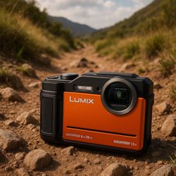
Gaviota Peak Trail (GPT) is about a 6 mile there and back hike. It is best to go early morning as the temperature can get pretty warm. It is recommended to bring layers of clothes as some areas can get chilly in the shade. Don't forget your water and sunscreen. On this trail you have the ability to venture off to the hot springs if that is to your liking. On this hike I enjoyed the fact the path was wide and pretty maintained. Individuals of all ages can do the hike. Enjoy

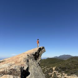
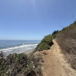
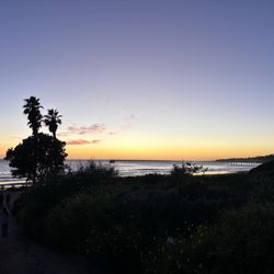
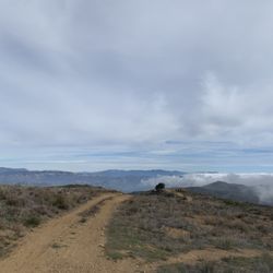
This is one of my favorite trails in the Los Angeles area...BUT....Do it in the winter after some rains. I have done this trail at the end of March and it was green, lush, and absolutely gorgeous. The mountains/hills at the top (just past the peak) were full of water so it looked like mini lakes which rippled in the breeze at the top. I hiked this trail again in July and it was dry and not as exciting or pretty to look at. Some cool points.... - I love that this trail varies from rolling meadows, to the peak with ocean views, to a cave, and groves of California live oaks. - I love the cave!! So fun to climb around in! - The hot springs on this trail is an added bonus. It's maybe 1/4 mile up the trail off a small, almost hidden side trail. We did the loop and then hiked back up to soak in the hot springs. - Take Trespass trail back down. It's a little more narrow/overgrown but you get some great ocean views. Things to know: - The hot springs can get crowded on the weekend. There were about 10 people there the first time I went, but no one during the week. - Wear long pants and watch out for poison oak.

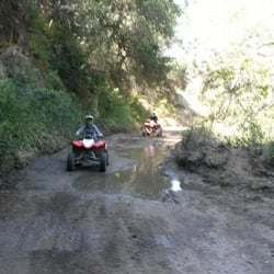
You will get a good workout on this trail , moderate difficulty ,3 mile to get to the peak , first 2 miles are ok but the last mile is steeper . You can go down trespass trail for the scenic ocean view but make sure you wear hiking shoes and long pants , the trail is very narrow and steep with plenty of bushes, uneven slopes with rocks, it can be quite intimidating for beginners. Going up walking will take about 1 hour . There's a lot of flies at the peak , maybe because the marker also serves as a trash can.

Being active seniors, we attempted this moderate rated hiking trail. Although we did not make it to the peak due to the tremendous incline, our round-trip on the trespass trail ended up being 8 miles. I don't know how all trails comes up with their distance. We did not deviate off onto the side trails. There were some spectacular views on the way up of the ocean and the surrounding mountains sides which was very enjoyable. Although the trail started out very wide, it narrows to merely a foot path and at one point becomes a death trap because there is barely room for 1 foot in front of the other because of the erosion which would make it easy to lose your footing and slide off the cliff. We had hoped to also see the Hot Springs, but by the time we got back down the hill to the .7 hiking path to them, we had hiked four hours and will save it for another day. We parked on the side of the road when we saw a line of cars, figuring that the parking lot ahead was full. This turned out not to be the case. Although the parking lot is not very big, there is parking. It is easy to find this hiking area, it is right off of exit 132 of the freeway and the parking is right by the sign on the side road. Even if you are not an avid hiker, this trail is worthwhile to go up for a moderate distance just to enjoy the surrounding beauty. We determined that the tunnel trail loops around and connects with the trespass trail from the lower part to the midway part. This looks like it would be a nice little hike as well and an easy one. Hiking boots are recommended because of the inclines and mud in areas as well as rocks in others. This is not a trail to bring young children on. Dogs are prohibited and I can understand why. There are no restrooms in the area, even in the parking lot, and there is no where to sit and take a break during the hike.

No dogs allowed :( This is a great hike with fantastic views. Most of the people you meet on SB trails are very nice but I don't take chances and I don't hike alone without my dog. There is a sign at the trailhead but I swear I thought it was a picture of a horse! Okay so I'm a dork but I think people should be warned before they make the hour long car trip. My hiking book said nothing about dogs not being allowed on the trail.

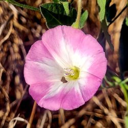
One of the hardest hike I ever had... as a beginner.. just started hiking this year, probably this is my 4th hike but my first time to do almost 6.5 miles. It was a non stop walking climbing up the peak.. Beautiful scenery all around, so green and flowers everywhere.. The pathways were wide and clear. It was definitely an experience!

6 months ago
Love this hike, always a bit nervous of running into a mountain lion. Great hike. Start in the left side and loop around when you get to the peak. The views are beautiful going down, so worth it. 6.40 miles, know led it out in 2hours. Take water, wear pants and bring your 4x4 shoes lol. read more


This is such a great hike! 4 miles up and 4 miles back (despite AllTrails saying 6 miles round trip). You can go the same way back or around the other side via Trespass Trail. I have done this hike twice, both in the last month or so. The first time we did the gravel way up and back. The second time we did Trespass Trail up and the gravel way back. My bf really liked the latter (lots of big steps/rocks) , but I did not and would rather do the gravel route. However, it is noteworthy to add that the gravel route has essentially no views and Trespass Trail has views of the ocean almost the whole time. The view at the top is gorgeous and well worth the hike. I recommend going on a cooler day as there is not much shade. read more

1 year ago
4 years ago
Gaviota Peak Trail (GPT) is about a 6 mile there and back hike. It is best to go early morning as the temperature can get pretty warm. It is recommended to bring layers of clothes as some areas can get chilly in the shade. Don't forget your water and sunscreen. On this trail you have the ability to venture off to the hot springs if that is to your liking. On this hike I enjoyed the fact the path was wide and pretty maintained. Individuals of all ages can do the hike. Enjoy read more


This is one of my favorite trails in the Los Angeles area...BUT....Do it in the winter after some rains. I have done this trail at the end of March and it was green, lush, and absolutely gorgeous. The mountains/hills at the top (just past the peak) were full of water so it looked like mini lakes which rippled in the breeze at the top. I hiked this trail again in July and it was dry and not as exciting or pretty to look at. Some cool points.... - I love that this trail varies from rolling meadows, to the peak with ocean views, to a cave, and groves of California live oaks. - I love the cave!! So fun to climb around in! - The hot springs on this trail is an added bonus. It's maybe 1/4 mile up the trail off a small, almost hidden side trail. We did the loop and then hiked back up to soak in the hot springs. - Take Trespass trail back down. It's a little more narrow/overgrown but you get some great ocean views. Things to know: - The hot springs can get crowded on the weekend. There were about 10 people there the first time I went, but no one during the week. - Wear long pants and watch out for poison oak. read more


3 years ago
9 years ago
You will get a good workout on this trail , moderate difficulty ,3 mile to get to the peak , first 2 miles are ok but the last mile is steeper . You can go down trespass trail for the scenic ocean view but make sure you wear hiking shoes and long pants , the trail is very narrow and steep with plenty of bushes, uneven slopes with rocks, it can be quite intimidating for beginners. Going up walking will take about 1 hour . There's a lot of flies at the peak , maybe because the marker also serves as a trash can. read more


6 years ago
7 years ago
Being active seniors, we attempted this moderate rated hiking trail. Although we did not make it to the peak due to the tremendous incline, our round-trip on the trespass trail ended up being 8 miles. I don't know how all trails comes up with their distance. We did not deviate off onto the side trails. There were some spectacular views on the way up of the ocean and the surrounding mountains sides which was very enjoyable. Although the trail started out very wide, it narrows to merely a foot path and at one point becomes a death trap because there is barely room for 1 foot in front of the other because of the erosion which would make it easy to lose your footing and slide off the cliff. We had hoped to also see the Hot Springs, but by the time we got back down the hill to the .7 hiking path to them, we had hiked four hours and will save it for another day. We parked on the side of the road when we saw a line of cars, figuring that the parking lot ahead was full. This turned out not to be the case. Although the parking lot is not very big, there is parking. It is easy to find this hiking area, it is right off of exit 132 of the freeway and the parking is right by the sign on the side road. Even if you are not an avid hiker, this trail is worthwhile to go up for a moderate distance just to enjoy the surrounding beauty. We determined that the tunnel trail loops around and connects with the trespass trail from the lower part to the midway part. This looks like it would be a nice little hike as well and an easy one. Hiking boots are recommended because of the inclines and mud in areas as well as rocks in others. This is not a trail to bring young children on. Dogs are prohibited and I can understand why. There are no restrooms in the area, even in the parking lot, and there is no where to sit and take a break during the hike. read more


11 years ago
No dogs allowed :( This is a great hike with fantastic views. Most of the people you meet on SB trails are very nice but I don't take chances and I don't hike alone without my dog. There is a sign at the trailhead but I swear I thought it was a picture of a horse! Okay so I'm a dork but I think people should be warned before they make the hour long car trip. My hiking book said nothing about dogs not being allowed on the trail. read more

One of the hardest hike I ever had... as a beginner.. just started hiking this year, probably this is my 4th hike but my first time to do almost 6.5 miles. It was a non stop walking climbing up the peak.. Beautiful scenery all around, so green and flowers everywhere.. The pathways were wide and clear. It was definitely an experience! read more


10 years ago
Gaviota Peak is a challenging hike very good exercise and the hot springs are cool spot to check out to on the way up to the peak read more


8 years ago
11 years ago
More info about Gaviota Peak Trail
Gaviota Peak
Goleta, CA 93117
Directions
Hours
Indoor Amenities
Outdoor Amenities
Ask the Community - Gaviota Peak Trail
Review Highlights - Gaviota Peak Trail


Why does Yelp recommend reviews?
1 review that is not currently recommended
The reviews below are not factored into the business's overall star rating.
8 years ago
Gaviota Peak Trail - hiking - Updated July 2026
Best of Goleta
People found Gaviota Peak Trail by searching for…
Trending Searches in Goleta, CA
Blueberry Picking near Gaviota Peak Trail
Boat Tours near Gaviota Peak Trail
Cliff Jumping near Gaviota Peak Trail
Day Trips near Gaviota Peak Trail
Dog Friendly Things To Do near Gaviota Peak Trail
Jet Ski Rental near Gaviota Peak Trail
Kayak Rental near Gaviota Peak Trail
Kids Activities Indoor near Gaviota Peak Trail
Off Road Trails near Gaviota Peak Trail
Outdoor Activities near Gaviota Peak Trail
Peach Picking near Gaviota Peak Trail
Places To Walk Around near Gaviota Peak Trail
Public Shower near Gaviota Peak Trail
River Swimming near Gaviota Peak Trail
Rock Quarry near Gaviota Peak Trail
Scenic Night View near Gaviota Peak Trail
Scenic Overlook near Gaviota Peak Trail
State Parks near Gaviota Peak Trail
Surf Shop near Gaviota Peak Trail
Swimming Holes near Gaviota Peak Trail
Swimming Lakes near Gaviota Peak Trail
Things To Do On A Rainy Day near Gaviota Peak Trail
Tubing near Gaviota Peak Trail
View Points near Gaviota Peak Trail
Watch Sunset near Gaviota Peak Trail
Browse Articles
Browse Nearby
BEST of Goleta, California Restaurants near Gaviota Peak Trail
BEST of Goleta, California Coffee near Gaviota Peak Trail
BEST of Goleta, California Breakfast near Gaviota Peak Trail
BEST of Goleta, California Things to Do near Gaviota Peak Trail
BEST of Goleta, California Wineries near Gaviota Peak Trail
BEST of Goleta, California Campgrounds near Gaviota Peak Trail
BEST of Goleta, California Thrift Stores near Gaviota Peak Trail
Browse Brands
Related Searches in Goleta, CA
Affordable Kayak Rental Services in Goleta, California
Best Dog Hiking Trails Around Goleta, California
Best Fishing Locations and Guides in Goleta, California
Best Nature Trails for Hiking in Goleta, California
Best Places for Horseback Riding in Goleta, California
Best Sightseeing Experiences Available in Goleta, California
Check Out Off Road Trails in Goleta, California
Discover Dog Friendly Trails to Explore in Goleta, California
Discover Kid Friendly Hiking Trails in Goleta, California
Discover Popular Bike Trails in Goleta, California
Discover Top State Parks to Visit in Goleta, California
Discover a Hiking Trail in Goleta, California
Discover the Best Fishing Lake in Goleta, California
Discover the Best Night Hike Trails in Goleta, California
Dog-Friendly Hikes With Dogs in Goleta, California
Enjoy Camping Adventures Around Goleta, California
Enjoy Exciting Mountain Biking Adventures in Goleta, California
Enjoy Kayaking Adventures in Goleta, California
Enjoy Off Leash Dog Hikes in Goleta, California
Enjoy Tent Camping Spots Around Goleta, California
Enjoy a Beautiful Waterfall Hike in Goleta, California
Enjoy the Best Picnic Spots and Ideas in Goleta, California
Enjoy the Best Walking Trails in Goleta, California
Explore Beautiful Parks and Green Spaces in Goleta, California
Explore Easy Hikes Perfect for All in Goleta, California
Explore Fun Activities to Do in Goleta, California
Explore Popular Campgrounds Near Goleta, California
Explore Top Dog Parks in Goleta, California Near You
Explore the Best Beach Spots in Goleta, California
Family Friendly Hiking With Kids in Goleta, California
Find Popular Ziplining Spots Around Goleta, California
Find Top Dog Friendly Parks to Visit in Goleta, California
Find Top-Rated Waterfalls in Goleta, California Now
Find the Best Parks for Picnics in Goleta, California
Find the Best Playgrounds to Visit in Goleta, California
Find the Best Scenic View Locations in Goleta, California
Hiking Trails With Waterfalls in Goleta, California
Off Leash Dog Hiking Trails in Goleta, California
Popular Outdoor Activities to Try in Goleta, California
Popular Picnic Spots to Visit in Goleta, California
Popular Waterfall Hiking Trails in Goleta, California
Safe River Swimming Areas in Goleta, California
Safe and Fun Parks for Kids in Goleta, California
Top Hiking Trails to Explore in Goleta, California
Top Playgrounds for Kids to Enjoy in Goleta, California
Top Running Trails to Explore in Goleta, California
Top Things to Do With Kids in Goleta, California


