Wells-Elings Marsh Trail Photos


You might also consider
More like Wells-Elings Marsh Trail
Recommended Reviews - Wells-Elings Marsh Trail
Start your review...

Reviews With Photos

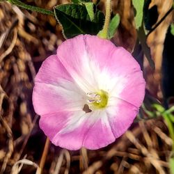
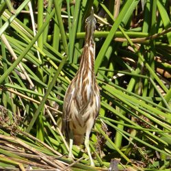
This is a semi-hidden new trail mainly known by neighbors and locals, but open for all to enjoy. There are two trailheads that merge (easiest access is off Stroke Road and Whittier Drive on UCSB's north campus) with a total of 2.5 miles to stroll. The property was most recently a golf course but has since been adopted and is being retransformed into it's original glory of when the Chumash roamed the lands. The area is more of a marshland and sloughs exist when tides are high. Keep in mind that restoration efforts are under way, with a visitors center and parking lot. For now, you can park for free along the neighboring streets. If you're a bird lover, it's the ideal location for bird watching: Commodores, herons, egrets, ducks and more can be spotted here. This well maintained trail is a perfect starting point to link to others trails going to/from Coal Oil Point Reserve (take the beautiful Pond Trail toward the snowy plover habitat) and the in-season monarch butterfly Elwood Bluffs. If you enjoy the area as much as I do, you can make a donation toward its restoration through UCSB's Cheadle Center for Biodiversity & Ecological Restoration (CCBER) to continue their work.

3 years ago
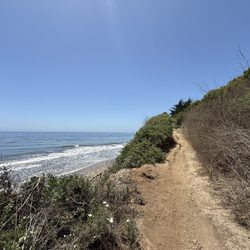
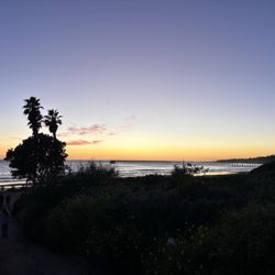
Great trail that leads right to the beach! Beautiful views to enjoy at all times. I saw a lot of people running, walking their dogs, and even birdwatching. Anyone can enjoy this splendid trail. read more


4 years ago
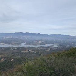
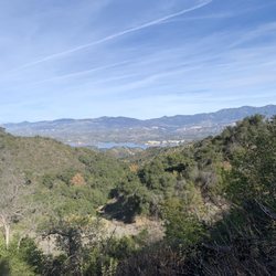
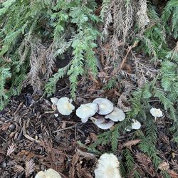
I walk this trail almost every day - I've literally been out here about a thousand times, and it never gets old! This trail at the north end of Devereaux Slough and the North Campus Open Space passes several beautiful ponds and takes you from the handy new parking lot to the beginning of the eucalyptus groves on the west end. The trail connects to several others, giving a few different routes to get from the neighborhood to the beach. There are also some convenient benches here and there so it is accessible if you have somewhat limited mobility. It is currently a gravel path so may not be 100% accessible to all, though. There are so many species of birds that come through here, locals and migratory, that I've become a much more avid birder since moving nearby. You can also see a lot of ground squirrels and lizards, and hear a chorus of frogs at night. Near the parking lot is an informative "outdoor school" where you can learn more about the restoration project and local ecology. I would highly recommend this as a spot to run, walk your dog, do some birding, watch the egrets at sunset, or let the kids zoom around! read more

This is a semi-hidden new trail mainly known by neighbors and locals, but open for all to enjoy. There are two trailheads that merge (easiest access is off Stroke Road and Whittier Drive on UCSB's north campus) with a total of 2.5 miles to stroll. The property was most recently a golf course but has since been adopted and is being retransformed into it's original glory of when the Chumash roamed the lands. The area is more of a marshland and sloughs exist when tides are high. Keep in mind that restoration efforts are under way, with a visitors center and parking lot. For now, you can park for free along the neighboring streets. If you're a bird lover, it's the ideal location for bird watching: Commodores, herons, egrets, ducks and more can be spotted here. This well maintained trail is a perfect starting point to link to others trails going to/from Coal Oil Point Reserve (take the beautiful Pond Trail toward the snowy plover habitat) and the in-season monarch butterfly Elwood Bluffs. If you enjoy the area as much as I do, you can make a donation toward its restoration through UCSB's Cheadle Center for Biodiversity & Ecological Restoration (CCBER) to continue their work. read more


7 years ago
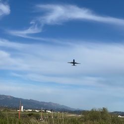
We were in Home Depot and wanted a quick hike near the area. Thanks for the first Yelp review for the tips. We found a place to park outside of UCSB. It was a nice walk to the beach with diverse views. It was also a nice easy bike trail and we saw several people biking. The beach was secluded and most likely not busy because school has not started. read more


More info about Wells-Elings Marsh Trail
Goleta, CA 93117
Directions
Hours
Outdoor Amenities
Ask the Community - Wells-Elings Marsh Trail


Wells-Elings Marsh Trail - hiking - Updated August 2026
Best of Goleta
People found Wells-Elings Marsh Trail by searching for…
Trending Searches in Goleta, CA
Blueberry Picking near Wells-Elings Marsh Trail
Boating near Wells-Elings Marsh Trail
Cinema near Wells-Elings Marsh Trail
Cliff Jumping near Wells-Elings Marsh Trail
Day Trips near Wells-Elings Marsh Trail
Dog Friendly Things To Do near Wells-Elings Marsh Trail
Flower Fields near Wells-Elings Marsh Trail
Jet Skis near Wells-Elings Marsh Trail
Kayak Rental near Wells-Elings Marsh Trail
Kids Activities Indoor near Wells-Elings Marsh Trail
Lakes near Wells-Elings Marsh Trail
Lookout Points near Wells-Elings Marsh Trail
Outdoor Activities near Wells-Elings Marsh Trail
Parks near Wells-Elings Marsh Trail
Peach Picking near Wells-Elings Marsh Trail
River Swimming near Wells-Elings Marsh Trail
Rock Quarry near Wells-Elings Marsh Trail
Scenic Drive near Wells-Elings Marsh Trail
Sunrise View near Wells-Elings Marsh Trail
Surf Shop near Wells-Elings Marsh Trail
Swimming Holes near Wells-Elings Marsh Trail
Things To Do On A Rainy Day near Wells-Elings Marsh Trail
Watch Sunset near Wells-Elings Marsh Trail
Browse Articles
Browse Nearby
BEST of Goleta, California Coffee near Wells-Elings Marsh Trail
BEST of Goleta, California Restaurants near Wells-Elings Marsh Trail
BEST of Goleta, California Parks near Wells-Elings Marsh Trail
BEST of Goleta, California Things to Do near Wells-Elings Marsh Trail
BEST of Goleta, California Walking Trails near Wells-Elings Marsh Trail
BEST of Goleta, California Breakfast near Wells-Elings Marsh Trail
BEST of Goleta, California Campgrounds near Wells-Elings Marsh Trail
BEST of Goleta, California Visitor Centers near Wells-Elings Marsh Trail
BEST of Goleta, California Day Trips near Wells-Elings Marsh Trail
Browse Brands
Related Searches in Goleta, CA
Affordable Kayak Rental Services in Goleta, California
Best Dog Hiking Trails Around Goleta, California
Best Fishing Locations and Guides in Goleta, California
Best Nature Trails for Hiking in Goleta, California
Best Places for Horseback Riding in Goleta, California
Best Sightseeing Experiences Available in Goleta, California
Check Out Off Road Trails in Goleta, California
Discover Dog Friendly Trails to Explore in Goleta, California
Discover Kid Friendly Hiking Trails in Goleta, California
Discover Popular Bike Trails in Goleta, California
Discover Top State Parks to Visit in Goleta, California
Discover a Hiking Trail in Goleta, California
Discover the Best Fishing Lake in Goleta, California
Discover the Best Night Hike Trails in Goleta, California
Dog-Friendly Hikes With Dogs in Goleta, California
Enjoy Camping Adventures Around Goleta, California
Enjoy Exciting Mountain Biking Adventures in Goleta, California
Enjoy Kayaking Adventures in Goleta, California
Enjoy Off Leash Dog Hikes in Goleta, California
Enjoy Tent Camping Spots Around Goleta, California
Enjoy a Beautiful Waterfall Hike in Goleta, California
Enjoy the Best Picnic Spots and Ideas in Goleta, California
Enjoy the Best Walking Trails in Goleta, California
Explore Beautiful Parks and Green Spaces in Goleta, California
Explore Easy Hikes Perfect for All in Goleta, California
Explore Fun Activities to Do in Goleta, California
Explore Popular Campgrounds Near Goleta, California
Explore Top Dog Parks in Goleta, California Near You
Explore the Best Beach Spots in Goleta, California
Family Friendly Hiking With Kids in Goleta, California
Find Popular Ziplining Spots Around Goleta, California
Find Top Dog Friendly Parks to Visit in Goleta, California
Find Top-Rated Waterfalls in Goleta, California Now
Find the Best Parks for Picnics in Goleta, California
Find the Best Playgrounds to Visit in Goleta, California
Find the Best Scenic View Locations in Goleta, California
Hiking Trails With Waterfalls in Goleta, California
Off Leash Dog Hiking Trails in Goleta, California
Popular Outdoor Activities to Try in Goleta, California
Popular Picnic Spots to Visit in Goleta, California
Popular Waterfall Hiking Trails in Goleta, California
Safe River Swimming Areas in Goleta, California
Safe and Fun Parks for Kids in Goleta, California
Top Hiking Trails to Explore in Goleta, California
Top Playgrounds for Kids to Enjoy in Goleta, California
Top Running Trails to Explore in Goleta, California
Top Things to Do With Kids in Goleta, California