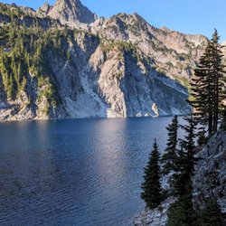
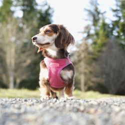
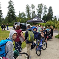
Henry's Ridge Open Space Photos


You might also consider
More like Henry's Ridge Open Space
Recommended Reviews - Henry's Ridge Open Space
Start your review...

2 years ago
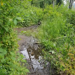
First solo hike and it was very quiet but very peacefult. Felt like you could get easily lost, so I pulled up Google Maps to guide me through and thoroughly enjoyed my time. It was a maintained hike behind a neighborhood. When I arrived, another soloist, a biker, was leaving. I was the only one on this hike and didnt feel terrified at all. You could hear the sounds of the freeway and the sounds of hunting season. This trail as for bikers, runners, and hikers. Most of the trail was flat, but some points along the Snake Trail had some ascending turns. Overall, I definitely recommend if you want an adventure. Not much of a sight, but there is a lake and river you can enjoy along the Ravensdale trail. Didnt stay though. With me getting lost-ish/exploring different paths, I only took about an hour. read more


More info about Henry's Ridge Open Space
253rd Pl SE
Maple Valley, WA 98038
Directions
Hours
Outdoor Amenities
You might also consider


Henry's Ridge Open Space - hiking - Updated July 2026
Best of Maple Valley
People found Henry's Ridge Open Space by searching for…
Things to Do in Maple Valley, WA
Hiking Trails in Maple Valley, WA
Walking Trails in Maple Valley, WA
Stroller Friendly Hikes in Maple Valley, WA
Secluded Spots in Maple Valley, WA
Walking Groups in Maple Valley, WA
Running Trails in Maple Valley, WA
Waterfalls and Swimming Holes in Maple Valley, WA
Tourist Attractions in Maple Valley, WA
Bike Paths in Maple Valley, WA
Lakes & Ponds in Maple Valley, WA
Off Leash Dog Hikes in Maple Valley, WA
Off Road Trails in Maple Valley, WA
Walking Path in Maple Valley, WA
Places to Take Pictures in Maple Valley, WA
Scenic Views in Maple Valley, WA
Places to Visit in Maple Valley, WA
Fun Places to Go in Maple Valley, WA
Scenic Drive in Maple Valley, WA
Fishing Spots in Maple Valley, WA
Trending Searches in Maple Valley, WA
Blueberry Picking near Henry's Ridge Open Space
Cliff Jumping near Henry's Ridge Open Space
Day Trips near Henry's Ridge Open Space
Dog Friendly Beaches near Henry's Ridge Open Space
Jet Ski Rental near Henry's Ridge Open Space
Kayak Rental near Henry's Ridge Open Space
Lakes & Ponds near Henry's Ridge Open Space
Off Road Trails near Henry's Ridge Open Space
Outdoor Activities near Henry's Ridge Open Space
Peach Picking near Henry's Ridge Open Space
Places To Swim near Henry's Ridge Open Space
Places To Walk Around near Henry's Ridge Open Space
Pokemon Go near Henry's Ridge Open Space
Pool Day Pass near Henry's Ridge Open Space
Public Shower near Henry's Ridge Open Space
River Swimming near Henry's Ridge Open Space
River Tubing near Henry's Ridge Open Space
Rock Quarry near Henry's Ridge Open Space
Scenic Night View near Henry's Ridge Open Space
Scenic Overlook near Henry's Ridge Open Space
Secluded Spots near Henry's Ridge Open Space
Soccer Store near Henry's Ridge Open Space
Sunrise View near Henry's Ridge Open Space
Swimming Holes near Henry's Ridge Open Space
Swimming Lakes near Henry's Ridge Open Space
U Pick Farms near Henry's Ridge Open Space
Browse Articles
Browse Nearby
BEST of Maple Valley, Washington Coffee near Henry's Ridge Open Space
BEST of Maple Valley, Washington Restaurants near Henry's Ridge Open Space
BEST of Maple Valley, Washington Things to Do near Henry's Ridge Open Space
BEST of Maple Valley, Washington Parks near Henry's Ridge Open Space
BEST of Maple Valley, Washington Lakes near Henry's Ridge Open Space
BEST of Maple Valley, Washington Breakfast near Henry's Ridge Open Space
Browse Brands
Related Searches in Maple Valley, WA
Affordable Kayak Rental Services in Maple Valley, Washington
Best Dog Hiking Trails Around Maple Valley, Washington
Best Fishing Locations and Guides in Maple Valley, Washington
Best Nature Trails for Hiking in Maple Valley, Washington
Best Places for Horseback Riding in Maple Valley, Washington
Best Sightseeing Experiences Available in Maple Valley, Washington
Check Out Off Road Trails in Maple Valley, Washington
Discover Dog Friendly Trails to Explore in Maple Valley, Washington
Discover Easy Hiking Trails Near Maple Valley, Washington
Discover Kid Friendly Hiking Trails in Maple Valley, Washington
Discover Popular Bike Trails in Maple Valley, Washington
Discover Scenic Mountain Bike Trails Near Maple Valley, Washington
Discover Walking Parks in Maple Valley, Washington Near You
Discover a Hiking Trail in Maple Valley, Washington
Discover the Best Night Hike Trails in Maple Valley, Washington
Dog-Friendly Hikes With Dogs in Maple Valley, Washington
Enjoy Camping Adventures Around Maple Valley, Washington
Enjoy Kayaking Adventures in Maple Valley, Washington
Enjoy Off Leash Dog Hikes in Maple Valley, Washington
Enjoy Scenic Places to Walk in Maple Valley, Washington
Enjoy Tent Camping Spots Around Maple Valley, Washington
Enjoy a Beautiful Waterfall Hike in Maple Valley, Washington
Enjoy the Best Walking Path in Maple Valley, Washington
Enjoy the Best Walking Trails in Maple Valley, Washington
Explore Beautiful Parks and Green Spaces in Maple Valley, Washington
Explore Easy Hikes Perfect for All in Maple Valley, Washington
Explore Fun Activities to Do in Maple Valley, Washington
Explore Popular Campgrounds Near Maple Valley, Washington
Explore Popular Dog Walking Trails in Maple Valley, Washington
Explore Top Dog Parks in Maple Valley, Washington Near You
Explore the Best Beach Spots in Maple Valley, Washington
Family Friendly Hiking With Kids in Maple Valley, Washington
Find Popular Ziplining Spots Around Maple Valley, Washington
Find Top-Rated Waterfalls in Maple Valley, Washington Now
Find the Best Parks for Picnics in Maple Valley, Washington
Hiking Trails With Waterfalls in Maple Valley, Washington
Off Leash Dog Hiking Trails in Maple Valley, Washington
Popular Outdoor Activities to Try in Maple Valley, Washington
Popular Picnic Spots to Visit in Maple Valley, Washington
Popular Waterfall Hiking Trails in Maple Valley, Washington
Safe River Swimming Areas in Maple Valley, Washington
Safe and Fun Parks for Kids in Maple Valley, Washington
Top Hiking Trails to Explore in Maple Valley, Washington
Top Playgrounds for Kids to Enjoy in Maple Valley, Washington
Top Running Trails to Explore in Maple Valley, Washington
Top Swimming Lakes to Enjoy in Maple Valley, Washington
Top Swimming Spots and Pools in Maple Valley, Washington
Top-Rated Camping Sites in Maple Valley, Washington
Walk Dog Friendly Hiking Trails in Maple Valley, Washington
Walk the Best Paved Walking Trails in Maple Valley, Washington
People who viewed Henry's Ridge Open Space also viewed
Lake Sawyer Park Foundation
1 review
Taylor Mountain Trail
1 review
Margaret's Way
7 reviews
Wilderness Creek Trail- Cougar Mtn.
6 reviews
Squak Mountain State Park
22 reviews
Rattlesnake Mountain
30 reviews
Teneriffe Falls Kamikaze Falls
29 reviews
Green River Community College Fitness Trail
4 reviews
Green River Trail
3 reviews
Honey Dew Trailhead
1 review