
West Tiger 3 Photos


You might also consider
More like West Tiger 3
Recommended Reviews - West Tiger 3
Start your review...

Reviews With Photos

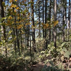
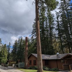
It had been ten years since I had been up the Tiger Mountain West trail. But Seattle and Portland had been cloaked in fog for several days, and I craved to see sunlight. A rumor existed that sunshine was to be found on mountaintops in the area. So I headed out here to Tiger Mountain this past weekend. You can see the lower parking area for the Tiger Mountain trail at Exit 20 on I-90. Several other people had the same idea, because the trail was busy. It was so cold, frosty and gray at the trailhead (32 degrees) that I thought I had to be a little crazy to be doing this. Up and down the mountain took me about 2.5 hours. The elevation gain is nearly 2500 feet. The trail is stern and uncompromising - climbing relentlessly upward - with few, if any, flat sections. Note: towards the top, there were a few small slick snow fields on the trail that had to be traversed. It was so bitterly cold that, shortly into the hike, I had to change into thicker gloves. But about 45 minutes up the trail, the fog thinned and the sun was out. The temperature was so much warmer above the clouds that I took off my gloves and outerwear. As I neared the top, people coming down promised me the sunshine at the top would be well worth the hike. The temperature was worth it too -- it was in the upper 60s at the top. Just a like a summer day! Sweet! While Tiger Mountain West offers a vigorous workout, it unfortunately lacks scenic views. Near the top in one spot, you do sort of have a glimpse through the trees of the Cascades and the valley below. At the top itself, there is a little clearing, and you can see out somewhat towards the west and also look up and view the taller Tiger Mountain East peak. I've never continued on the trail to Tiger Mountain East from Tiger Mountain West, but plan to do that next time. Today, though I am stiff and sore and can hardly move, when all is said and done, the hike and the accompanying sunshine were worth it!

Ever since I got rid of the title of "couch potato", I have fallen in love with hiking, especially the ones along I-90. Though, West Tiger # 3 is my favorite trail by far because I've made it up there 3 times (twice with my dogs and once with my friend, Laura and my dogs). For the most of you, this is probably nothing, but for a used-to-be-a-couch-potato like me, this is a big accomplishment. This is probably the most visible and accessible Trail along I-90 and it's just off the exit 20. I always came here when it's sunny, therefore, I can't really tell you what it's like when it's rainy or snowy. Regardless, it's a good and challenging trail. It took me approximately 1:30 to 2 hours to hike up the top. I'd say, 70% of the uphill is steep, but it's still good enough for trail runners to run up and down fast. I never carried poles, but I saw people carry them for the hike. If you are out of shape, be aware, you might not be able to make it to the top the first time. But, don't get discouraged! I saw a lot of people who didn't make it! I believe from the bottom of the trail to the top is approximately 3-mile hike. Because it's steep when you go up, it doesn't mean it's easy when you go down. They rocky trail can make you slip even in a dry day if you are not careful. Proper footwear is highly recommended! On top of the trail, it's a great view point of mountains (I believe it's Issaquah Alps). There's an little plateau area where you can walk around, take pictures, sit, rest, picnic, etc. I normally stayed on the top for 20 mins or so and headed down. I enjoyed the hike so much and I think I'd make it my regular hike spot! Hopefully, I can get more friends to join me :-)

Oh man, this was one heck of a hike. Being from Texas, hiking is rarely scenic there. So when I got to Seattle, I knew I was going to hike as much as I could before going back to TX. A good friend told me about this trail and warned that the beginning and end are the steepest parts. He was right. The hike up is 3 miles and it took me about 2 hrs to summit. I went on a Tuesday morning at around 9am. Perfect time of day cause there weren't a lot of people on the trail. I summited and found that the views up there weren't mind blowing but they were nice. Running down the trail was pretty easy and it took me about 45 minutes to get to the bottom. The entire hike was quite a workout and now my glutes, hams and quads are painfully sore. The trail itself is well maintained and very scenic. Love love love this trail and I'll definitely be back.

I like the hike, the trail bed is relatively easy. the one thing I dislike about this trail is the number of flies on the route. I can only attribute it the the amount of dog feces left from un leashed or uncontrolled dogs.. as the non traveled trails are fly free.. dogs run off into the woods. go poop and release 1000's of flies from each crap.. I try the trail at night when the flies go down.

My GF and I hiked Poo Poo Point. It took us practically an hour to find the trial head. It's tricky because the school is under construction and the signage is poor. Basically, after you get on 2nd ave, you drive through to the older high school bldgs, then all the way to the back. There is a small graveled parking lot near the softball field. There's a tiny yellow sign that nobody ever sees that says "Temporary trail relocation, follow fence along softball field." Can you tell I'm still bitter. Once you start your journey, the climb is never-ending. Then, you will randomly descend for a while followed by a sign that sign Poo Poo Point is a mile back from where you initially descended. But don't be discouraged, just keep swimming.. just keep swimming. It's worth it to get to summit! I can say, without a doubt, Poo Poo Point offers one of the most spectacular views of the west I've ever seen!! You nearly get to see the entire coast beyond Bellevue. One of the most romantic hikes I've been on. I just wish it was only accessible to hikers. We were gasping by the time we reached the top only to see two people in a car drive to the top. Unfair!!

4 years ago
So fun!! My partner and I met up with a friend to hike part of Tiger Mountain during our Seattle trip. Great excuse to get out of the city. We parked at High Point Trailhead, which is right next to the West Tiger #3 Trail. Who named this? Anyways, relatively easy route compared to the rest of Tiger Mountain. Since we had a small kiddo with us, I've decided we'll come back for the longer, more intense trails. We didn't follow the ENTIRE path because I remember doubling back at this spooky cave part of West Tiger. I liked the various open spaces to stop and take a break, letting others pass by. There weren't too many people when we were there. Overall, because I live in a fairly urban area back home, it's a fun escape to encounter lush greenery and mossy goodness. Not a fan of that texture, but it's very pretty. read more

It had been ten years since I had been up the Tiger Mountain West trail. But Seattle and Portland had been cloaked in fog for several days, and I craved to see sunlight. A rumor existed that sunshine was to be found on mountaintops in the area. So I headed out here to Tiger Mountain this past weekend. You can see the lower parking area for the Tiger Mountain trail at Exit 20 on I-90. Several other people had the same idea, because the trail was busy. It was so cold, frosty and gray at the trailhead (32 degrees) that I thought I had to be a little crazy to be doing this. Up and down the mountain took me about 2.5 hours. The elevation gain is nearly 2500 feet. The trail is stern and uncompromising - climbing relentlessly upward - with few, if any, flat sections. Note: towards the top, there were a few small slick snow fields on the trail that had to be traversed. It was so bitterly cold that, shortly into the hike, I had to change into thicker gloves. But about 45 minutes up the trail, the fog thinned and the sun was out. The temperature was so much warmer above the clouds that I took off my gloves and outerwear. As I neared the top, people coming down promised me the sunshine at the top would be well worth the hike. The temperature was worth it too -- it was in the upper 60s at the top. Just a like a summer day! Sweet! While Tiger Mountain West offers a vigorous workout, it unfortunately lacks scenic views. Near the top in one spot, you do sort of have a glimpse through the trees of the Cascades and the valley below. At the top itself, there is a little clearing, and you can see out somewhat towards the west and also look up and view the taller Tiger Mountain East peak. I've never continued on the trail to Tiger Mountain East from Tiger Mountain West, but plan to do that next time. Today, though I am stiff and sore and can hardly move, when all is said and done, the hike and the accompanying sunshine were worth it! read more

Ever since I got rid of the title of "couch potato", I have fallen in love with hiking, especially the ones along I-90. Though, West Tiger # 3 is my favorite trail by far because I've made it up there 3 times (twice with my dogs and once with my friend, Laura and my dogs). For the most of you, this is probably nothing, but for a used-to-be-a-couch-potato like me, this is a big accomplishment. This is probably the most visible and accessible Trail along I-90 and it's just off the exit 20. I always came here when it's sunny, therefore, I can't really tell you what it's like when it's rainy or snowy. Regardless, it's a good and challenging trail. It took me approximately 1:30 to 2 hours to hike up the top. I'd say, 70% of the uphill is steep, but it's still good enough for trail runners to run up and down fast. I never carried poles, but I saw people carry them for the hike. If you are out of shape, be aware, you might not be able to make it to the top the first time. But, don't get discouraged! I saw a lot of people who didn't make it! I believe from the bottom of the trail to the top is approximately 3-mile hike. Because it's steep when you go up, it doesn't mean it's easy when you go down. They rocky trail can make you slip even in a dry day if you are not careful. Proper footwear is highly recommended! On top of the trail, it's a great view point of mountains (I believe it's Issaquah Alps). There's an little plateau area where you can walk around, take pictures, sit, rest, picnic, etc. I normally stayed on the top for 20 mins or so and headed down. I enjoyed the hike so much and I think I'd make it my regular hike spot! Hopefully, I can get more friends to join me :-) read more


12 years ago
Oh man, this was one heck of a hike. Being from Texas, hiking is rarely scenic there. So when I got to Seattle, I knew I was going to hike as much as I could before going back to TX. A good friend told me about this trail and warned that the beginning and end are the steepest parts. He was right. The hike up is 3 miles and it took me about 2 hrs to summit. I went on a Tuesday morning at around 9am. Perfect time of day cause there weren't a lot of people on the trail. I summited and found that the views up there weren't mind blowing but they were nice. Running down the trail was pretty easy and it took me about 45 minutes to get to the bottom. The entire hike was quite a workout and now my glutes, hams and quads are painfully sore. The trail itself is well maintained and very scenic. Love love love this trail and I'll definitely be back. read more


I like the hike, the trail bed is relatively easy. the one thing I dislike about this trail is the number of flies on the route. I can only attribute it the the amount of dog feces left from un leashed or uncontrolled dogs.. as the non traveled trails are fly free.. dogs run off into the woods. go poop and release 1000's of flies from each crap.. I try the trail at night when the flies go down. read more

My GF and I hiked Poo Poo Point. It took us practically an hour to find the trial head. It's tricky because the school is under construction and the signage is poor. Basically, after you get on 2nd ave, you drive through to the older high school bldgs, then all the way to the back. There is a small graveled parking lot near the softball field. There's a tiny yellow sign that nobody ever sees that says "Temporary trail relocation, follow fence along softball field." Can you tell I'm still bitter. Once you start your journey, the climb is never-ending. Then, you will randomly descend for a while followed by a sign that sign Poo Poo Point is a mile back from where you initially descended. But don't be discouraged, just keep swimming.. just keep swimming. It's worth it to get to summit! I can say, without a doubt, Poo Poo Point offers one of the most spectacular views of the west I've ever seen!! You nearly get to see the entire coast beyond Bellevue. One of the most romantic hikes I've been on. I just wish it was only accessible to hikers. We were gasping by the time we reached the top only to see two people in a car drive to the top. Unfair!! read more

The best little hike just got better! They paved the road and parking lot!! Woo hoo! No more pot holes! This hike is a northwest favorite! Miles of trails for all abilities, beautiful views for those willing to work a little harder and some of the best hiking close to the city! read more

13 years ago
13 years ago
16 years ago
17 years ago
14 years ago
17 years ago
17 years ago
Fun to hike all year round... Yack tracks suggested for the snow, but I made it up without. Pack a thermos of tea for the colder weather. In the summer, the summit would be fun to have lunch. read more


16 years ago
Great workout with a little one in the pack. Not the best view but very great trail and nice gradual climb. read more

14 years ago
19 years ago
18 years ago
16 years ago
15 years ago
17 years ago
15 years ago
14 years ago
More info about West Tiger 3
Tiger Mountain
Issaquah, WA 98027
Directions
Visit Website
http://issaquahalps.org
Hours
Outdoor Amenities
Ask the Community - West Tiger 3
Review Highlights - West Tiger 3
You might also consider


West Tiger 3 - hiking - Updated July 2026
Best of Issaquah
People found West Tiger 3 by searching for…
Swimming Holes in Issaquah, WA
Mountain Bike Trails in Issaquah, WA
Places to Take Pictures in Issaquah, WA
Beautiful Views in Issaquah, WA
Off Leash Dog Hiking Trails in Issaquah, WA
Urban Exploration in Issaquah, WA
Paved Walking Trails in Issaquah, WA
Calisthenics Park in Issaquah, WA
Fun Things to Do With Kids in Issaquah, WA
Swimming Lakes in Issaquah, WA
Waterfall Hike in Issaquah, WA
Trending Searches in Issaquah, WA
Blueberry Picking near West Tiger 3
Cliff Jumping near West Tiger 3
Dog Friendly Things To Do near West Tiger 3
Kayak Rental near West Tiger 3
Lookout Points near West Tiger 3
Off Road Trails near West Tiger 3
Outdoor Activities near West Tiger 3
Peach Picking near West Tiger 3
Picnic Spots near West Tiger 3
Public Pools near West Tiger 3
Public Shower near West Tiger 3
River Swimming near West Tiger 3
Scenic Overlook near West Tiger 3
Sunrise View near West Tiger 3
Swimming Holes near West Tiger 3
Swimming Lakes near West Tiger 3
Things To Do On A Rainy Day near West Tiger 3
U Pick Farms near West Tiger 3
Browse Articles
Browse Nearby
Browse Brands
Related Searches in Issaquah, WA
Affordable Kayak Rental Services in Issaquah, Washington
Best Dog Hiking Trails Around Issaquah, Washington
Best Fishing Locations and Guides in Issaquah, Washington
Best Nature Trails for Hiking in Issaquah, Washington
Best Places for Horseback Riding in Issaquah, Washington
Best Sightseeing Experiences Available in Issaquah, Washington
Check Out Off Road Trails in Issaquah, Washington
Discover Dog Friendly Trails to Explore in Issaquah, Washington
Discover Easy Hiking Trails Near Issaquah, Washington
Discover Kid Friendly Hiking Trails in Issaquah, Washington
Discover Popular Bike Trails in Issaquah, Washington
Discover Scenic Mountain Bike Trails Near Issaquah, Washington
Discover Walking Parks in Issaquah, Washington Near You
Discover a Hiking Trail in Issaquah, Washington
Discover the Best Night Hike Trails in Issaquah, Washington
Dog-Friendly Hikes With Dogs in Issaquah, Washington
Enjoy Camping Adventures Around Issaquah, Washington
Enjoy Kayaking Adventures in Issaquah, Washington
Enjoy Off Leash Dog Hikes in Issaquah, Washington
Enjoy Scenic Places to Walk in Issaquah, Washington
Enjoy a Beautiful Waterfall Hike in Issaquah, Washington
Enjoy the Best Walking Path in Issaquah, Washington
Enjoy the Best Walking Trails in Issaquah, Washington
Explore Beautiful Parks and Green Spaces in Issaquah, Washington
Explore Easy Hikes Perfect for All in Issaquah, Washington
Explore Fun Activities to Do in Issaquah, Washington
Explore Popular Campgrounds Near Issaquah, Washington
Explore Popular Dog Walking Trails in Issaquah, Washington
Explore Top Dog Parks in Issaquah, Washington Near You
Explore the Best Beach Spots in Issaquah, Washington
Family Friendly Hiking With Kids in Issaquah, Washington
Find Popular Ziplining Spots Around Issaquah, Washington
Find Top-Rated Waterfalls in Issaquah, Washington Now
Find the Best Parks for Picnics in Issaquah, Washington
Find the Best Playgrounds to Visit in Issaquah, Washington
Hiking Trails With Waterfalls in Issaquah, Washington
Off Leash Dog Hiking Trails in Issaquah, Washington
Popular Outdoor Activities to Try in Issaquah, Washington
Popular Picnic Spots to Visit in Issaquah, Washington
Popular Waterfall Hiking Trails in Issaquah, Washington
Safe River Swimming Areas in Issaquah, Washington
Safe and Fun Parks for Kids in Issaquah, Washington
Top Hiking Trails to Explore in Issaquah, Washington
Top Playgrounds for Kids to Enjoy in Issaquah, Washington
Top Running Trails to Explore in Issaquah, Washington
Top Swimming Lakes to Enjoy in Issaquah, Washington
Top Swimming Spots and Pools in Issaquah, Washington
Top-Rated Camping Sites in Issaquah, Washington
People who viewed West Tiger 3 also viewed
Coal Creek Falls Trail
45 reviews
Poo Poo Point - Chirico Trail
166 reviews
Wilderness Creek Trail- Cougar Mtn.
6 reviews
Bandera Mountain
13 reviews
Cherry Creek Falls Trail
43 reviews
Rattlesnake Ridge
170 reviews
Big Creek Falls - Taylor River Trail
3 reviews
Around the Lake Trail
1 review
Snoqualmie Point Park
18 reviews
Honey Dew Trailhead
1 review