Cancel

    Open app

    Search

    Hackpen White Horse Photos

    Recommended Reviews - Hackpen White Horse

    Your trust is our priority, so businesses can't pay to alter or remove their reviews. Learn more about reviews.
    Yelp app icon
    Browse more easily on the app
    Review Feed Illustration
    Photo of Helen M.
    0
    422
    835

    18 years ago

    Helpful 0
    Thanks 0
    Love this 0
    Oh no 0

    Verify this business for free

    Get access to customer & competitor insights.

    Verify this business

    Avebury Stone Circle - Roof of a pigeon and dove barn. 15th century when they bred birds for food.

    Avebury Stone Circle

    4.8(38 reviews)
    3.6 mi

    Avebury Stone Circle is one of the world's greatest prehistoric monuments: older than Stonehenge,…read moreit is the largest megalithic stone circle (henge) anywhere, and part of what was once an enormous megalithic complex stretching for miles. To me, it's more impressive and more spiritual a place than Stonehenge, despite the fact there's a road and village within its structure. History As ever with such sites, our knowledge is limited, but like Stonhenge, it is likely to have been built in phases. The best guess is that construction began around 2600BC with the inner circles, with the great ditch and outer circle completed around 2500BC, making it contemporaneous with the Pyramids at Giza. When completed, these circles included about 154 stones (only 36 remain today) and it also had two avenues 50 feet wide on either side, extending another one and a half miles. Excavations indicate it was probably used as a ritual site for some 2,300 years. A mile to the south is the artificial Silbury Hill, which must also have formed a related part of this complex, although its purpose is now unkown. Nearby Windmill Hill - an important settlement in Neolithic times - also has some burial mounds from the Bronze Age. As well as natural degradation, the monument suffered hugely during the mediaeval period when the Christian authorities actively encouraged demolition of what was regarded as a Pagan monument. This process accelerated in the 17th and 18th centuries, when local people also broke up the stones for building material. But as late as the 1720s, the great antiquarian Dr William Stukeley was able to trace the original plan, including the avenues: although his interpretation of this as a Druid site is now regarded as inaccurate, his drawings and surveys provide our best record of what it looked like. Alas, the destruction of the stones by local farmers continued unabated into the 19th century. The 20th century showed a greater interest in and respect for the site, and - rather controversially - many of the stones were re-erected in the 1930s by the archaeologist Alexander Keiller. This involved in some cases demolition of later buildings, themselves of some historical interest. I happen to think he was right to try and preserve what was left, but many contextual historians disagree. Whatever the rights and wrongs, the site is now safely in the hands of the English Heritage and managed by the National Trust. The site Today, the most impressive feature is the great ditch and its banks: the excavation of this feature - nearly 0.5km in diameter - involved moving 200,000 tonnes of soil and rock. It may even once have been filled with water to make the interior and island. Even now, the ditch and bank together are impressive, but originally they were even deeper/higher (at around 50ft). Inside this are the remains of the outer circle, which is nearly complete in the north west and south west corners. The remains of the two inside circles are more fragmentary. Unlike Stonehenge, here you can walk right up to the stones, so allow at least a couple of hours to visit properly. Don't miss walking south from the main henge monument along the West Kennet Avenue - around 30 standing stones arranged in pairs (to the form the avenue). Practicalities There is a gift shop and museum in the nearby Barn and Stables (themselves 17th century buildings) with interactive displays to put everything into context. The museums are fully accessible, but the main site has undulating grassy terrain (without footpaths) which are accessed through "kissing gates". The ground can get soft and rather boggy underfoot if it has been raining, so you will have to judge for yourself. There is a drop-off point in the village. Parking is the main problem: there is a pay and display car park (free for motorcycles and National Trust Members), on the A4361 road between Beckington and Avebury about 400m from the edge of the henge. This can become packed very quickly in the summer. There's a more central car park for those with disabled parking badges - the Red Lion car park is only for patrons. The village of Avebury itself is worth a wander around (Avebury Manor - see separate review - and the Red Lion especially, although it does get terribly busy at weekends in summer). For the most part, you'll still be inside the monument itself!

    I almost feel educated!‍ We enjoyed this pre Stonehenge!…read more Keeps getting ! Keeps getting stranger!

    Photos
    Avebury Stone Circle
    Avebury Stone Circle
    Avebury Stone Circle - Red Lion pub

    See all

    Red Lion pub

    Bibury

    Bibury

    5.0(2 reviews)
    20.1 mi

    Bibury is a charming, typically Cotswold. It's easy to see why William Morris called Bibury 'The…read moremost beautiful village in England' - wonderful stone buildings strung out along the banks of the River Coln. Arlington Row, owned by the National Trust, is one of England's most iconic and photographed sites - it even appears on the inside cover of UK passports! Originally built in the 14th century as a monastic wool store, it was converted in the 17th century into a row of weavers' cottages. The River Coln flows through Bibury sandwiched between the main village street and an expanse of boggy water meadow known as Rack Isle, so called because wool was once hung out to dry there on racks after it had been washed in Arlington Row. You can even see some trout in the river, which the trout farm owners told us they are the escape artists! With Arlington Row as a backdrop, it makes one of the most picturesque scenes you will find in the Cotswolds. Other attractions in Bibury include: Bibury Trout Farm, (see my other review) one of the oldest and most attractive trout farms in the country covering almost 15 acres, where you can learn about trout or event catch your own dinner. This village is stunning, perfect photographers dream. Do come you will not be disappointed.

    If traveling past Oxford don't miss out on this picturesque little town, offering a prime example…read moreof the Cotswold way of living. Houses are maintained in much the old fashion, offering not just wonderful photo opportunities but also a glimpse into housing of the past . You will find several small tea houses and shops here, as well as a trout farm and hotel. Well worth a visit or even a relaxing weekend.

    Photos
    Bibury
    Bibury - Biburys river and hotel and pub

    Biburys river and hotel and pub

    Bibury

    See all

    Silbury Hill

    Silbury Hill

    4.5(8 reviews)
    4.3 mi

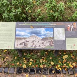
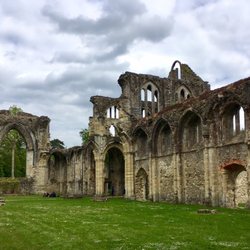
    Okay, so at one level this is just an artificial mound. But it happens to be nearly 4,500 years old…read moreand, at over 30m in height, is the largest prehistoric artificial mound in Europe. So it something special. It forms part of the Avebury UNESCO World Heritage Site, along with the nearby West Kennet Long Barrow, and the Avebury Stone Circle and adjacent avenues (see separate reviews on Yelp), and can be visited as part of a day trip around all of the sites. Excavation has shown the mound was not built in one go, but in a series of enlargements, undertaken between about 2470 and 2350 BC. These included excavation of a series of increasingly larger outer ditches (one of which was water filled), and placing the chalk rubble onto the mound. It is not known what the mound was used for, but it was clearly something of great significance to the Neolithic people, and forms part of the wider Neolithic landscape of henge monuments and burial mounds. Over the course of the following years, a small Roman settlement was built next to the mound, and in mediaeval times, the top of the mound was flattened, possibly for defensive use. Inevitably, over the years, the mound has become the subject of a number of myths and legends. There have been three major campaigns of excavation. The first was financed by Hugh Percy, Duke of Northumberland, in 1776. Overseen by Edward Drax, miners were employed to dig a vertical shaft from the summit to the centre of the hill. They had hoped to discover a burial in the centre, but found nothing. The next attempt in 1849 saw John Merewether, the Dean of Hereford Cathedral, excavating a horizontal tunnel into hill from its base. Again, no burial was found. It is possible that these earlier excavations may have damaged fragile organic remains. I am old enough to remember the third major investigation, which was undertaken between 1968 and 1970. Televised by the BBC, it was a major and regular item on the news. Professor Richard Atkinson excavated a new tunnel on a similar line to Merewether's, and identified three phases of construction. Further work was undertaken in 2000, when it was found necessary to restore part of the mound, which had begun to collapse because of the earlier excavations. This has added significantly to understanding of the complex process of construction. Located alongside the modern A4 road, there's a decent sized car park just west of the site, with a path to a viewing area with information boards. You are no longer allowed to scramble over the mound itself, but a footpath to the north allows a different perspective. You can get another close view from the nearby A4 road if you can brave the traffic (there is a narrow pavement, but with vehicles whizzing close by at 60mph, it is not very pleasant, nor safe for those with children).

    This is a sight to see. No solid reason why the Neolithic population spent decades raising a hill…read morethis high. Science has done 3 tunnels over 150 years for discovery, but no result. Each 50 years apart. Why? Another religion or astronomy guess. Done by hand over decades. That would involve generations and continued guidance and a firm purpose. No one is allowed on the hill. Privately owned by one family for many generations to preserve its history. There are sheep trails on it. All done by hand, a basket at a time. . Who decided when it was done. ?

    Photos
    Silbury Hill
    Silbury Hill - The trench and the  mound  Decades to make.

    The trench and the mound Decades to make.

    Silbury Hill - Silbury Hill from West Kennet Long Barrow

    See all

    Silbury Hill from West Kennet Long Barrow

    Titchfield Abbey

    Titchfield Abbey

    4.0(3 reviews)
    49.6 mi

    On our Road Trip through England, Wales and Scotland we focused on Castles, Abbeys and walks…read more The Titchfield Abbey we've visited on our first full day here in England. It was a hot summer day. A monday. And only really a handful people on site. Which is surprising, because these are beautiful remains of a former abbey and mansion. It's almost still fully complete even. There's no entrance fee. And even parking is free if you're a member of the EH. If not it's 2£ only. The building is very impressive. Built in the 13th Century it was first in the hand of monks. Then it changed hands under Henry VIII. And was turned into a Tudor mansion. It's quite a sight to behold. And you can walk around the whole site. But as usual: Be respectful, don't climb around and pick up your litter and after your dog (which are allowed here on the site). A very good start for this year's Road Trip. A great place to visit. And there are even one or two lunch options around, if you feel hungry after your visit.

    Titchfield Abbey is a ruined former country home, which was itself adapted from an Abbey during the…read moreDissolution. The Abbey was founded in 1222 by the Premonstratensian Order of canons. It was founded as a daughter house of Halesowen Abbey, and endowed both by its founder Bishop Peter of Winchester and Henry III. Never especially wealthy, the Abbey was nevertheless noted for its scholarship and held a substantial library. The Abbey buildings followed a standard plan, albeit on a relatively modest scale. The Abbey seems to have had a quiet and ordered existence, although it's location near the south coast on one of the main routes to France meant it hosted both Richard II and Henry V, and was the location of Henry VI to Margaret of Anjou in 1445. The Abbey was dissolved in 1537, at the behest of Thomas Wriothesely, Chancellor to Henry VIII. Unlike many dissolutions, the Abbott John Salisbury secured a peaceful handover, with pensions provided for the canons and the position of Dean of Norwich for himself in 1539. Wriothesely adapted the buildings to form a n impressive country home for himself, called Place House. The Abbey church itself was converted to a grand gatehouse and accommodation wing, with a long gallery and hall formed around the former cloister. This involved taking down the church tower and chancel. The house hosted Elizabeth I, Edward VI, Charles I and Charles II. It continued in use as a home until the 1780s, when the decision was taken to abandon and deliberately demolish much of the complex to form a romantic ruin. Today it is in the care of English Heritage. The impressive turreted gatehouse forms the larger part of what is visible today, the bare structure enabling much of the former church to be traced. There are also remains of the cloister walls, with the foundations of the demolished buildings traced out on the ground. The site is also known for its collection of decorative mediaeval floor tiles. The adjacent fish ponds have survived but are no longer part of the site. Practicalities: the gravel drive is quite narrow and leads to a gravel car park. Although there is level access the rough surfaces make for challenging wheelchair access. There are no toilets on site.

    Photos
    Titchfield Abbey
    Titchfield Abbey
    Titchfield Abbey

    See all

    The Magic Roundabout - Forget what Buffy told you, this is the true location of The Hellmouth.

    The Magic Roundabout

    3.8(4 reviews)
    6.5 mi

    Have you ever been on vacation, driving merrily along minding your own business, when whoopsie, you…read morehave to hit the brakes as you've unknowingly entered a gateway to the Nightmare dimension? The Magic Roundabout, a godforsaken collection of mini-roundabouts (or minibouts) that connect 4 main artery routes and a relatively minor road (sorry Shrivenham Rd.), was physically built in 1972, but conceived far earlier way back in 1937 by H.P. Lovecraft while languishing on his deathbed, emotionally distraught by the realisation that Cthulhu wasn't the ultimate evil after all and he simply had to jot down his maniacal design on paper. The fact that the layout of the minibouts of the Magic Roundabout form the basic outline of an upside down pentagram is as blatant a calling card of evil as you could ever expect to see The MR is apparently a 'landmark that Swindon is famous for', which should tell you everything you need to know about Swindon in 6-words and exactly why you should consider investing an additional 10-hours to driving around it instead of through it. Throw in the fact that I traversed this mess with a stunned, wide-eyed American in the car, unused to both roundabouts (they're quite the tourist attraction in the USA and all seem to require a mandatory 3-miles of warning signs to mentally prepare a driver to tackle one) and driving on the left side of the road, which only added to the overall sense of panic and impending doom. We survived the Magic Roundabout, which is more than some can say. Legend has it that Dave Bailey from Oxford failed to sacrifice a chicken or say the appropriate prayers before entering the roundabout back in 1983 and remains there to this day, his white van driving in endless futile circles, doomed for eternity to try and find the exit for the M4.

    I don't drive. I usual encounter this when in the car with my Mum, who can be a little worried…read more Invariably as we approach she starts telling me to keep quiet until we are past, at length, until I'm really wishing she'd stop talking and drive, but my mouth is, of course, tight shut. Actually I think she's probably a lot better at it than she thinks. And Marg2k8's explanation makes some sort of sense! It still remains a little scary, with traffic coming at you from what seems like all directions! If you'd like a look before tackling it, then on the map top right go to 'explore this area', then switch to satellite, and zoom in. It's sort of two rings, one going clockwise, one anti, with four islands and four smaller roundabouts in between. I can't help wondering if they've ever built one of these elsewhere since?

    Hackpen White Horse - landmarks - Updated May 2026

    Loading...
    Loading...
    Loading...