Gass Peak Photos

)) - Hiking Near Me - Las Vegas, Nevada")


You might also consider
More like Gass Peak
Recommended Reviews - Gass Peak
Start your review...

Reviews With Photos - Gass Peak

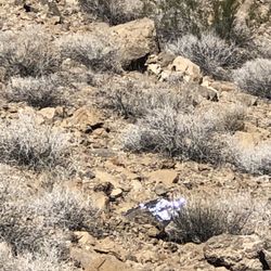
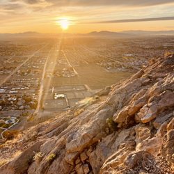
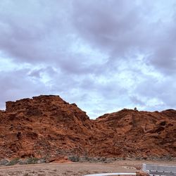
Gass Peak (Desert National Wildlife Refuge / Las Vegas, NV) 2019 52-Hike Challenge Done!! AllTrails describes Gass Peak as a 6.1 mile out & back, lightly trafficked trail with a 2,129 ft. elevation gain. AllTrails also rates this hike as difficult. I didn't think that the hike to the top was extremely difficult. I'm not stating that to summit was a breeze, but it's definitely not easy, especially when Mother Nature decides to bring on the snow. We accomplished this hike on December 29, 2019. We started from the trailhead at exactly 9:15 AM, took a few small breaks, and reached the peak at 11:32 AM. The trail itself was easy to follow until we reached a stretch of snow, which started around mile 1 and continued to the peak. I had an easier time identifying the trail from a distance, focusing on specific points to reach (i.e. big rocks, trees, patches of snow, dry areas, etc.) and doing our best to stay on the trail to summit. We relied on footprints from other hikers and animal paw prints when we reached areas where snow completely covered the trail. The first mile is a gradual incline with an elevation gain of about 500 feet. The steep climbing starts at about mile 1.20. From there, it's almost all uphill with a total elevation gain of about 1,500 feet. The views from the top is amazing and includes the Las Vegas valley, parts of Utah, Red Rock Canyon, Spring Mountains National Recreational Area, all of the peaks that we accomplished this year (Mt. Charleston, Black Mountain, Frenchman/Sunrise, and Lone Mountain), our house, and In-N-Out Burger off North 5th Street. We took a few photos at the top, signed the logbook, and had a quick snack. The hike down was a lot easier to follow since we left clearly defined tracks on the snow, but it wasn't a cupcake and very slippery. It took us less than 2 hours from the peak to the trailhead. Total hike time was 4 hours and 10 minutes. Gass Peak is one of those hikes that took so long to accomplish because we didn't think we had a vehicle that can get us to the trailhead (review my tips) and because of weather. Hiking up to the peak is no picnic when snow is present. I assume it's even worse during the middle of summer since the entire trail is exposed. I would like to do this hike again once the snow melts off and before it gets hot. Overall, I love this hike. The distance, challenging inclines, and the views is why Gass Peak is one of my favorite hikes located close to home. TIPS: Tip #1: Just getting to the trailhead is an adventure. You will need a vehicle with enough clearance to make it through uneven and rocky terrain. My wife's Subie was our hero for the day. Her car maneuvered through the bumpy road like a champ. NOTE: We arrived at the trailhead using the directions from AllTrails. Tip #2: Carve out enough time to hike this beast. Our total hike time was over 4.5 hours with breaks. From the 215 & 95, it's another 2+ hours round-trip just to the trailhead. Do the math. We left our meet up spot in the Centennial area at 7:40 AM and arrived back at our meet up spot at 3:20 PM. Tip #3: The usual hike requirements is needed. Bring enough hydration and snacks. Dress according to the weather and I recommend hike boots. Poles are not mandatory by highly recommended if snow is present. Tip #4: There is very little internet or phone reception on this hike. The trail is also listed as "lightly trafficked". We saw no one on this trail. That being said, it's important that you give someone a heads up when you do this hike. Give them the time you plan to start and an estimated time you should be done. Gass Peak may be seen from all parts of the valley. But the trail is in the middle of nowhere. Tip #5: Don't take any part of the trail for granted. Remember, you're climbing a mountain. One false move can lead to bad things. I like good things. Be Safe!!

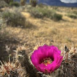
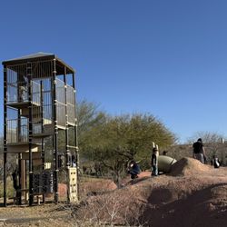
Gass Peak is the highest peak in the Las Vegas Range and is located in the Desert National Wildlife Refuge. The peak is named after Octavius D. Gass, an early Vegas settler who lived at Las Vegas Ranch for a period of time. This is not an easy flat hike. You'll need to come prepared. Plenty of water, sunscreen and appropriate clothes. I recommend long pants because your legs will get scratched going up and coming back down. A hat is highly recommended too as the sun beats down on you and there's no shade. Poles or a walking stick might be helpful to you going up and down. I can't stress enough how important the right shoes are to have when doing this hike. Might not sound like fun huh? It is fun though! If you love hiking and taking in the great outdoors, you'll want to conquer this peak. I feel like Gass Peak has been in my backyard my whole life. I grew up on the north side of town and have always been able to see it right outside my house. Getting to Gass Peak Road doesn't necessarily require a high clearance 4x4 vehicle, but I wouldn't recommend or do it without one. It will be one slow drive to the trailhead without it. You'll certainly need the proper vehicle if you decide to continue on Mormon Well Road as it gets rocky near Peek-A-Boo Canyon. Once you are headed down Gass Peak Road you'll need to look for the service road on the right, that's the trailhead where you'll park your vehicle and walk by foot from there. There's a small sign posted that says service road. The hike is about 6 miles. At times the trail disappears and it's pretty narrow, but you can just look ahead and get an idea of where it picks back up. When you get to the fork, you can go left or right to get to the peak, but the right way takes a smidge longer. If you go right at the fork make sure to keep an eye out for Gass Spring, which is actually just a man-made spring for the animals it's nothing fancy. There's a lot of up and down action you'll be doing. Be careful as it gets slippery especially where there's broken shale. Yes, you can find fossils here! This doesn't mean load up your backpack with shale. Don't be that person. Another thing you'll see depending on the time of year are a variety of plants, some endemic, meaning that are found nowhere else on earth. If you are lucky you'll get a glimpse of a Desert Bighorn Sheep, our state animal. You can see amazing views on this hike the higher up you get! You can see mountains in Utah, Arizona and California, get a view of Lake Mead and even the Stratosphere still looks tall and noticeable up there lol. Antennas adorn the peak and were actually brought up by helicopter. There's a windsock up there to let workers know where they need to go do maintenance. Pack a lunch and enjoy it at the top with an unforgettable view. Some people have mentioned bringing their dog on this hike, I personally don't think it's the best hike for most dogs. Going back down is slipperier than going up, so keep that in mind. I don't recommend this hike during the summer it's just too hot. Try hiking in the early spring or fall. Happy hiking!

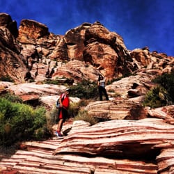
John Muir once said "the mountains are calling and I must go". This montra has fueled my lifelong wonderlust. I was born and raised in Las Vegas and always dreamed of climbing each mountain peak that forms the sky line. These peaks have haunted me, beckoned me, and dared me to try their mite. Gass peak imparticilar has called to me like a forbidden siren. My great friend Paul W and I developed a plan to summit Gass peak a year ago. There are some Web sites that provide detailed and easy to follow directions to get to the trailhead and ultimately, the summit. We researched as much as we could and set a date. With perfect weather and an early start, a long time goal was about to be reached. The 95 to the corn creek turn off was well marked. The road to the ranger station was newly paved. This turns to a rocky dirt road that provides appropriate signage. Take the Mormon wells road to Gass peak road. The mountains and rock formations along the way are visually spectacular and resemble beautiful anger as different minerals and rock have battled for turf rights millions of years ago. Like a great rock/earth battle field, you will quickly forget Las Vegas is 40 or so minutes away. The trailhead is obvious. It's a service road that you will need to follow to the right. You can gaze upon the summit from the start. It will call to you and taunt you along the way. There are multiple steep stretches of trail and very few flat ones. You travel along the spine of a prehistoric ridgeline that holds on to the view of the LV valley tightly. As you ascend the trail the valley quickly drops and provides a vast view of the diverse and impressive landscape. The top gets closer and the trail gets steeper. I would recommend some training before you take the 3.1 mile trail up around 1700 feet. Also water, lots of water. The summit has a large Antena and building with some big solar panels to absorb the plentiful sun and fuel the comm needs of the valley below. There is a nice area to unload, stretch out and take in the great accomplishment of making it to the top. My friend, Paul W and I have made many hikes and summits and loaded down our packs to train hard so that we may hunt easy for this particular adventure. As with any summit, it's euphoric to stand atop a mountain and gaze down into the valley below. This summit was even more so gratifying due to the fact I've been looking at this peak for my entire life. We ate at the summit and replenished our fuel and enjoyed the view for an hour or two. 360 degrees of great views almost overwhelmed our senses. With great sadness we had to head down and release our grip of the summit victory. The decent back into the valley is equally as beautiful and changes around every draw and corner. Be careful on the steep parts. The trail is well marked and ranges from limestone to jagged rock to sandstone to a volcanic wonderland. It is well worth the effort and a hike I will never forget.

Gass Peak is one of the highest peaks in the mountains surrounding the Vegas valley and a challenging climb. But if you can make it to the top, you'll find the Vegas valley (and Lake Mead) laid out before you to the South and a great view of the desert wilderness to the North. Gass Peak is located within the Desert National Wildlife Refuge and is the highest summit (6943 ft / 2116 m) in the Las Vegas mountain range (mountains that form the north-east barrier of the Las Vegas Valley). The only way to get to the hike is to head north on 95 and turn right onto a dirt road towards Corn Creek (turnoff is near mile marker 101). Word of warning: you'll need at least a high-clearance vehicle to drive the dirt roads in the Desert National Wildlife Refuge and a 4x4 vehicle is recommended. Stop at the visitor center and ask for directions to Gass Peak road (marked, but located about 45 minutes down some unfinished, rough and rocky desert roads--so worth some good directions from staff). Once you get to the trailhead, you'll face the steepest part of the climb up front--old roads now closed to the public that seem to go straight up and make your thighs and lungs burn. But push through that and you'll be on a winding trail (sort of -- you're following the marks made by people and animals, rather than a maintained trail). The trail winds up and around to the ridge of some smaller peaks. From there, you'll keep walking up and along mountain ridges (always looking west to the cell tower that marks Gass Peak). Once you're up on top of the smaller peaks, the climb gets easier (although steeper and there's a lot of slipping and sliding on the steeper paths). But keep going and you'll reach the peak looking out over the Vegas valley. There's a log book at the top with people signing in or leaving their thoughts while looking out over a desert metropolis to the South and an almost pristine mountain wilderness to the North. Best view I've found of Las Vegas and you'll earn the view with all the incline exercise. As usual, BirdandHike has an excellent description of the hike and great directions: http://www.birdandhike.com/Hike/DNWR/Gass_Peak/_Gass_Peak.htm

9 years ago
First of all, many thanks to Christie L. for extensively researching this hike and setting up a group event for us to scale this highest peak in Vegas! We went on a great fall day, and it's definitely a bucket list hike to set out to accomplish while living in the valley. As always, safety first. Note that you will need a high clearance 4WD vehicle (such as a Jeep) to get to the trailhead. Take more water than you think you will need and pack snacks or a lunch to eat at the summit. Our group agreed that hiking boots with good traction would be better for the terrain than sneakers. If you don't have good trail-finding skills, I suggest you go with someone who does, because there are times where it's difficult to follow but it is the best route. On the trail, keep an eye out for the silvery Cholla cactus, endemic to this area. I work out regularly and still found this hike to be more intense than I'd expected, partly due to the difficulty finding the trail but moreso due to the ever-changing terrain (from rocky to slippery slate to sandy to volcanic and back) and the steepness of the route. Going up, we took several breaks and went off trail, taking 4 hours to ascend, but the trail was more easily found on the way down and we took virtually no breaks and made it in 2 hours. Between 3 different fitness trackers, we got distances between 8-9 miles rather than the 6.5 round-trip stated on Bird & Hike. This is a challenging hike to undertake, but the views are incredible- you can see Lake Mead to the south and the grid-layout city view of Vegas is comparable to what you see from a plane. Many thanks again to Christie & Co for planning, navigating, and including me on this great hike! read more


Do you see that tower at the top of the mountain north of the valley? That's where you'll find Gass Peak. You may or may not be able to see the tower easily but trust me it's there. I think there's even a few blinking lights that's visible at night. The peak lines up almost directly with the Strip so you can easily see the farthest east and farthest west edges of the valley from the top. Getting to the trailhead requires you to do some off-roading a few miles in the middle of the Desert Wildlife Wildlife Refuge. Using a 4x4 vehicle isn't required but it certainly helps and makes it easier. You don't want to be stuck out there. I probably could've made it with my non-4x4 SUV. The hike itself can get difficult because a number of things but it's not extremely difficult. I would do a few easier hikes to prepare for this one especially if you haven't done a hike for a while. There is no shade so it can be hazardous on windy, sunny, or rainy days. There are parts of the trail that disappear. There are also parts of the trail that are steep or slippery where if you were to lose your balance or footing you'd get severely hurt. But for most parts the hike is just hiking or walking on an incline. I've read different info on how long the hike is so I'll just say it's at least 6 miles so you'll probably going to be out there for a few hours especially if you take lots of breaks, breaks are a good thing. Make sure you write your name in the notebook at the top or not. I'd do this hike again. I kind of want to know how the view is at night or at sunrise or sunset. read more


4 years ago
In A Nutshell: -If you are looking for solitude away from people, then Gass Peak is the hike for you. -This trail is located inside the Desert National Wildlife Range in Southern Nevada about 70 minutes from the Strip. -It's recommended that you have a truck, SUV or Subaru, basically a vehicle that can handle miles of off roading in dirt & rocks to get to the trailhead. -The journey to get to the trailhead is bumpy & fun. -Once you arrive at the trailhead the adventure starts. -Quick note, if you have T-Mobile you'll have 4G/5G service available most of the time, but there are some dead areas. -It's about a 6 mile out & back route up to Gass Peak. -The trail starts off flat, but then you'll start to go up the foothills until you get to the ridge. -You'll then walk along the ridge until you climb a little more to get to the summit. -Once you are there you'll notice the solar panels, radar dishes & a small building. -This is a good place to eat a meal, rehydrate & take in the awesome views of the Las Vegas Valley. -It does get windy & there is no shade along the trail. -I wore a hat, t-shirt & shorts on a 70 degree day, I did pack extra layers, but never had to use them. -I also brought along my dog, which is okay to do, but you should know the physical capabilities of your dog before you bring them (i.e. make sure their foot pads are used to rocky terrain otherwise leave them home). -It took us 1 hour 33 minutes to get to the summit. -Total trip was 2 hours 58 minutes w/ a nice 20 minute lunch break at the summit. Overall, I really enjoyed the solitude of the hike, I saw no people which I loved, I only saw a few birds & many Joshua Trees & native cholla cactus. If you want to clear your mind while getting a very strenuous workout I would do this hike. read more


Gass Peak (Desert National Wildlife Refuge / Las Vegas, NV) 2019 52-Hike Challenge Done!! AllTrails describes Gass Peak as a 6.1 mile out & back, lightly trafficked trail with a 2,129 ft. elevation gain. AllTrails also rates this hike as difficult. I didn't think that the hike to the top was extremely difficult. I'm not stating that to summit was a breeze, but it's definitely not easy, especially when Mother Nature decides to bring on the snow. We accomplished this hike on December 29, 2019. We started from the trailhead at exactly 9:15 AM, took a few small breaks, and reached the peak at 11:32 AM. The trail itself was easy to follow until we reached a stretch of snow, which started around mile 1 and continued to the peak. I had an easier time identifying the trail from a distance, focusing on specific points to reach (i.e. big rocks, trees, patches of snow, dry areas, etc.) and doing our best to stay on the trail to summit. We relied on footprints from other hikers and animal paw prints when we reached areas where snow completely covered the trail. The first mile is a gradual incline with an elevation gain of about 500 feet. The steep climbing starts at about mile 1.20. From there, it's almost all uphill with a total elevation gain of about 1,500 feet. The views from the top is amazing and includes the Las Vegas valley, parts of Utah, Red Rock Canyon, Spring Mountains National Recreational Area, all of the peaks that we accomplished this year (Mt. Charleston, Black Mountain, Frenchman/Sunrise, and Lone Mountain), our house, and In-N-Out Burger off North 5th Street. We took a few photos at the top, signed the logbook, and had a quick snack. The hike down was a lot easier to follow since we left clearly defined tracks on the snow, but it wasn't a cupcake and very slippery. It took us less than 2 hours from the peak to the trailhead. Total hike time was 4 hours and 10 minutes. Gass Peak is one of those hikes that took so long to accomplish because we didn't think we had a vehicle that can get us to the trailhead (review my tips) and because of weather. Hiking up to the peak is no picnic when snow is present. I assume it's even worse during the middle of summer since the entire trail is exposed. I would like to do this hike again once the snow melts off and before it gets hot. Overall, I love this hike. The distance, challenging inclines, and the views is why Gass Peak is one of my favorite hikes located close to home. TIPS: Tip #1: Just getting to the trailhead is an adventure. You will need a vehicle with enough clearance to make it through uneven and rocky terrain. My wife's Subie was our hero for the day. Her car maneuvered through the bumpy road like a champ. NOTE: We arrived at the trailhead using the directions from AllTrails. Tip #2: Carve out enough time to hike this beast. Our total hike time was over 4.5 hours with breaks. From the 215 & 95, it's another 2+ hours round-trip just to the trailhead. Do the math. We left our meet up spot in the Centennial area at 7:40 AM and arrived back at our meet up spot at 3:20 PM. Tip #3: The usual hike requirements is needed. Bring enough hydration and snacks. Dress according to the weather and I recommend hike boots. Poles are not mandatory by highly recommended if snow is present. Tip #4: There is very little internet or phone reception on this hike. The trail is also listed as "lightly trafficked". We saw no one on this trail. That being said, it's important that you give someone a heads up when you do this hike. Give them the time you plan to start and an estimated time you should be done. Gass Peak may be seen from all parts of the valley. But the trail is in the middle of nowhere. Tip #5: Don't take any part of the trail for granted. Remember, you're climbing a mountain. One false move can lead to bad things. I like good things. Be Safe!! read more


9 years ago
Gass Peak is the highest peak in the Las Vegas Range and is located in the Desert National Wildlife Refuge. The peak is named after Octavius D. Gass, an early Vegas settler who lived at Las Vegas Ranch for a period of time. This is not an easy flat hike. You'll need to come prepared. Plenty of water, sunscreen and appropriate clothes. I recommend long pants because your legs will get scratched going up and coming back down. A hat is highly recommended too as the sun beats down on you and there's no shade. Poles or a walking stick might be helpful to you going up and down. I can't stress enough how important the right shoes are to have when doing this hike. Might not sound like fun huh? It is fun though! If you love hiking and taking in the great outdoors, you'll want to conquer this peak. I feel like Gass Peak has been in my backyard my whole life. I grew up on the north side of town and have always been able to see it right outside my house. Getting to Gass Peak Road doesn't necessarily require a high clearance 4x4 vehicle, but I wouldn't recommend or do it without one. It will be one slow drive to the trailhead without it. You'll certainly need the proper vehicle if you decide to continue on Mormon Well Road as it gets rocky near Peek-A-Boo Canyon. Once you are headed down Gass Peak Road you'll need to look for the service road on the right, that's the trailhead where you'll park your vehicle and walk by foot from there. There's a small sign posted that says service road. The hike is about 6 miles. At times the trail disappears and it's pretty narrow, but you can just look ahead and get an idea of where it picks back up. When you get to the fork, you can go left or right to get to the peak, but the right way takes a smidge longer. If you go right at the fork make sure to keep an eye out for Gass Spring, which is actually just a man-made spring for the animals it's nothing fancy. There's a lot of up and down action you'll be doing. Be careful as it gets slippery especially where there's broken shale. Yes, you can find fossils here! This doesn't mean load up your backpack with shale. Don't be that person. Another thing you'll see depending on the time of year are a variety of plants, some endemic, meaning that are found nowhere else on earth. If you are lucky you'll get a glimpse of a Desert Bighorn Sheep, our state animal. You can see amazing views on this hike the higher up you get! You can see mountains in Utah, Arizona and California, get a view of Lake Mead and even the Stratosphere still looks tall and noticeable up there lol. Antennas adorn the peak and were actually brought up by helicopter. There's a windsock up there to let workers know where they need to go do maintenance. Pack a lunch and enjoy it at the top with an unforgettable view. Some people have mentioned bringing their dog on this hike, I personally don't think it's the best hike for most dogs. Going back down is slipperier than going up, so keep that in mind. I don't recommend this hike during the summer it's just too hot. Try hiking in the early spring or fall. Happy hiking! read more


10 years ago
John Muir once said "the mountains are calling and I must go". This montra has fueled my lifelong wonderlust. I was born and raised in Las Vegas and always dreamed of climbing each mountain peak that forms the sky line. These peaks have haunted me, beckoned me, and dared me to try their mite. Gass peak imparticilar has called to me like a forbidden siren. My great friend Paul W and I developed a plan to summit Gass peak a year ago. There are some Web sites that provide detailed and easy to follow directions to get to the trailhead and ultimately, the summit. We researched as much as we could and set a date. With perfect weather and an early start, a long time goal was about to be reached. The 95 to the corn creek turn off was well marked. The road to the ranger station was newly paved. This turns to a rocky dirt road that provides appropriate signage. Take the Mormon wells road to Gass peak road. The mountains and rock formations along the way are visually spectacular and resemble beautiful anger as different minerals and rock have battled for turf rights millions of years ago. Like a great rock/earth battle field, you will quickly forget Las Vegas is 40 or so minutes away. The trailhead is obvious. It's a service road that you will need to follow to the right. You can gaze upon the summit from the start. It will call to you and taunt you along the way. There are multiple steep stretches of trail and very few flat ones. You travel along the spine of a prehistoric ridgeline that holds on to the view of the LV valley tightly. As you ascend the trail the valley quickly drops and provides a vast view of the diverse and impressive landscape. The top gets closer and the trail gets steeper. I would recommend some training before you take the 3.1 mile trail up around 1700 feet. Also water, lots of water. The summit has a large Antena and building with some big solar panels to absorb the plentiful sun and fuel the comm needs of the valley below. There is a nice area to unload, stretch out and take in the great accomplishment of making it to the top. My friend, Paul W and I have made many hikes and summits and loaded down our packs to train hard so that we may hunt easy for this particular adventure. As with any summit, it's euphoric to stand atop a mountain and gaze down into the valley below. This summit was even more so gratifying due to the fact I've been looking at this peak for my entire life. We ate at the summit and replenished our fuel and enjoyed the view for an hour or two. 360 degrees of great views almost overwhelmed our senses. With great sadness we had to head down and release our grip of the summit victory. The decent back into the valley is equally as beautiful and changes around every draw and corner. Be careful on the steep parts. The trail is well marked and ranges from limestone to jagged rock to sandstone to a volcanic wonderland. It is well worth the effort and a hike I will never forget. read more


Gass Peak is one of the highest peaks in the mountains surrounding the Vegas valley and a challenging climb. But if you can make it to the top, you'll find the Vegas valley (and Lake Mead) laid out before you to the South and a great view of the desert wilderness to the North. Gass Peak is located within the Desert National Wildlife Refuge and is the highest summit (6943 ft / 2116 m) in the Las Vegas mountain range (mountains that form the north-east barrier of the Las Vegas Valley). The only way to get to the hike is to head north on 95 and turn right onto a dirt road towards Corn Creek (turnoff is near mile marker 101). Word of warning: you'll need at least a high-clearance vehicle to drive the dirt roads in the Desert National Wildlife Refuge and a 4x4 vehicle is recommended. Stop at the visitor center and ask for directions to Gass Peak road (marked, but located about 45 minutes down some unfinished, rough and rocky desert roads--so worth some good directions from staff). Once you get to the trailhead, you'll face the steepest part of the climb up front--old roads now closed to the public that seem to go straight up and make your thighs and lungs burn. But push through that and you'll be on a winding trail (sort of -- you're following the marks made by people and animals, rather than a maintained trail). The trail winds up and around to the ridge of some smaller peaks. From there, you'll keep walking up and along mountain ridges (always looking west to the cell tower that marks Gass Peak). Once you're up on top of the smaller peaks, the climb gets easier (although steeper and there's a lot of slipping and sliding on the steeper paths). But keep going and you'll reach the peak looking out over the Vegas valley. There's a log book at the top with people signing in or leaving their thoughts while looking out over a desert metropolis to the South and an almost pristine mountain wilderness to the North. Best view I've found of Las Vegas and you'll earn the view with all the incline exercise. As usual, BirdandHike has an excellent description of the hike and great directions: http://www.birdandhike.com/Hike/DNWR/Gass_Peak/_Gass_Peak.htm read more

 - Hiking Near Me - Las Vegas, Nevada")
I have always believed that a mountain was dragon. A dragon whom had snatched a virgin princess whom was never to be seen by anyone again. In this particular case, there once was a dragon called Gass (Peak). In 1996, I arrived in "The Meadows." When I would eventually get my bearings and properly orientate myself to the valley, when I looked north I spied the monstrosity. A curious glare would be cast down from above like the eye of Sauron when the sun would hit an angle along it's ecliptic. I would gaze on high and feel as if the summit called to me. Better yet........mocked me. It's taunts beckoned me to slay the beast and rescue the princess. Time would pass and pass..........and pass. Every morning I woke up and went about my business anywhere in the valley, when I looked north...there was the beast in all of it's magnificence...scorning me. Almost 20 years later, two knights (Zack M. & myself) with the passion of Don Quixote, formulated a plan to slay to giant. With one war chariot left at a nearby reservation, the two would take another more robust war chariot to the base of beast, slay it, and rescue the fair maiden. The path is well traveled and recently paved heading out to the Nevada Wildlife Refuge. At the only intersection, the direction (Mormon Well Road to Gass Peak Road) was easily illuminated. Smaller chariots were observed in the area but be forewarned, this is a rough road. This journey is not for the faint of heart and it is highly recommended that if attempted...in the months especially when it his hotter than Hades, one should plan for every contingency because despite the illusion...you are in wild country. WATER! Some 35 minutes of travel you can expect to find a very recognizable trail head. At this trail head, arrows were literally shot and heavy packs were laden on the backs of the knights in preparation for future battle. The two would march off looking to climb the spine of the tarragon. A word to the wise...when you meet the fork: TAKE THE RIGHT even when everything is telling to take the left. Up and up went the knights (who took a left and then blazed their own route). Strengthened by previous adventures, they went higher into clouds. When the beaten track began to fade, a cairn would materialize and show the way. Fearing that my time is running short as are my yelp characters, let me speed up this tale. We made our way up the spine of the beastie and this knight's lower armor (shorts) began to sag. Fortunately, beneath the armor lay another form of protection. When I reached the summit this knight became a jester, as I was now wearing my armor around my ankles. Armed now only with spandex, a timely spear of joy was thrust into the heart of Gass. The princess (view) had sadly (but expected) already been claimed. Many times in fact, but not by many yelpers. The summit log is located between the benchmarks, and it was full of previous conquistadors. Sauron is nothing but solar panels fueling the communication needs for various agencies. But this was the moment of greatness for Zack M. & Paul W. We celebrated our victory with song and the sweet taste of unicorn tears. Heading down what was now a trail of redemption and victory, my thoughts drifted to preparation for future adventures. As of 02/21/16, when I catch Gass Peak out of the corner of my eye, I can't help but smile and feel an overwhelming sense of satisfaction. GO SLAY YOUR DRAGON!! read more


More info about Gass Peak
Desert National Wildlife Refuge
Las Vegas, NV 89025
Directions
Hours
Outdoor Amenities
Ask the Community - Gass Peak
You might also consider


Gass Peak - hiking - Updated August 2026
Best of Las Vegas
People found Gass Peak by searching for…
Off Road Trails in Las Vegas, NV
Make Out Spot in Las Vegas, NV
Visitor Centers in Las Vegas, NV
Walking Trails in Las Vegas, NV
Running Trails in Las Vegas, NV
Hiking Trails in Las Vegas, NV
Hiking Groups in Las Vegas, NV
Waterfall Hike in Las Vegas, NV
Beautiful Views in Las Vegas, NV
Lakes & Ponds in Las Vegas, NV
Trending Searches in Las Vegas, NV
Browse Articles
Browse Nearby
Browse Brands
Related Searches in Las Vegas, NV
Best Dog Hiking Trails Around Las Vegas, Nevada
Best Fishing Locations and Guides in Las Vegas, Nevada
Best Places for Horseback Riding in Las Vegas, Nevada
Best Sightseeing Experiences Available in Las Vegas, Nevada
Check Out Off Road Trails in Las Vegas, Nevada
Discover Dog Friendly Trails to Explore in Las Vegas, Nevada
Discover Popular Bike Trails in Las Vegas, Nevada
Discover Scenic Mountain Bike Trails Near Las Vegas, Nevada
Discover Walking Parks in Las Vegas, Nevada Near You
Discover a Hiking Trail in Las Vegas, Nevada
Discover the Best Night Hike Trails in Las Vegas, Nevada
Dog-Friendly Hikes With Dogs in Las Vegas, Nevada
Enjoy Camping Adventures Around Las Vegas, Nevada
Enjoy Exciting Mountain Biking Adventures in Las Vegas, Nevada
Enjoy Kayaking Adventures in Las Vegas, Nevada
Enjoy Off Leash Dog Hikes in Las Vegas, Nevada
Enjoy Scenic Places to Walk in Las Vegas, Nevada
Enjoy Tent Camping Spots Around Las Vegas, Nevada
Enjoy a Beautiful Waterfall Hike in Las Vegas, Nevada
Enjoy the Best Walking Path in Las Vegas, Nevada
Enjoy the Best Walking Trails in Las Vegas, Nevada
Explore Beautiful Parks and Green Spaces in Las Vegas, Nevada
Explore Easy Hikes Perfect for All in Las Vegas, Nevada
Explore Fun Activities to Do in Las Vegas, Nevada
Explore Popular Campgrounds Near Las Vegas, Nevada
Explore Popular Dog Walking Trails in Las Vegas, Nevada
Explore Top Dog Parks in Las Vegas, Nevada Near You
Explore Top Water Parks in Las Vegas, Nevada Today
Family Friendly Hiking With Kids in Las Vegas, Nevada
Find Parks and Recreation Activities in Las Vegas, Nevada
Find Popular Ziplining Spots Around Las Vegas, Nevada
Find the Best Parks for Picnics in Las Vegas, Nevada
Hiking Trails With Waterfalls in Las Vegas, Nevada
Off Leash Dog Hiking Trails in Las Vegas, Nevada
Perfect Spots to Watch Sunset in Las Vegas, Nevada
Picnic Areas With BBQ Pits Available in Las Vegas, Nevada
Plan a Scenic Drive Route Near Las Vegas, Nevada
Play at a Splash Pad Park in Las Vegas, Nevada
Popular Outdoor Activities to Try in Las Vegas, Nevada
Popular Picnic Spots to Visit in Las Vegas, Nevada
Safe and Fun Parks for Kids in Las Vegas, Nevada
Top Hiking Trails to Explore in Las Vegas, Nevada
Top Playgrounds for Kids to Enjoy in Las Vegas, Nevada
Top Running Trails to Explore in Las Vegas, Nevada
Top Swimming Lakes to Enjoy in Las Vegas, Nevada
Top Swimming Spots and Pools in Las Vegas, Nevada
Top Things to Do With Kids in Las Vegas, Nevada
Top-Rated Camping Sites in Las Vegas, Nevada
People who viewed Gass Peak also viewed
Fletcher Canyon
34 reviews
Tule Springs Loop
5 reviews
Centennial
Buckskin Cliff Shadows Trailhead
9 reviews
Northwest
Desert Wildlife National Refuge
34 reviews
MT. Charleston Spring Mountains
25 reviews
Centennial
Upper Las Vegas Wash Trail
8 reviews
Macks Canyon hike
3 reviews
Mummy's Toe
3 reviews
Trail Canyon Trail
12 reviews
Holy Mountain
2 reviews
Centennial