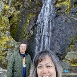
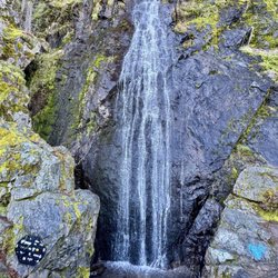
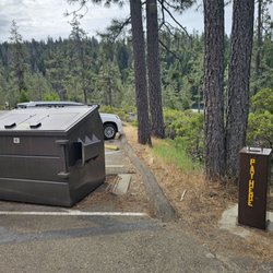
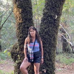
Foresthill Divide Loop Trail Photos


You might also consider
More like Foresthill Divide Loop Trail
Recommended Reviews - Foresthill Divide Loop Trail
Start your review...

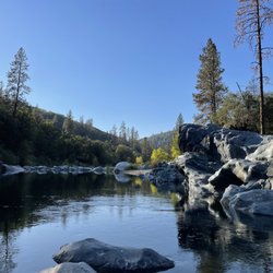
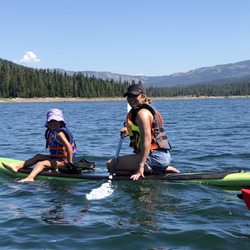
12/30/18 Easy hike with beautiful views of the Foresthill Bridge, the highest by deck height in California at 730 feet above the North Fork American River. I took my 3 and 14 year old girls and my baby had a blast. My 14 year old... eehhhh, wasn't too crazy about "another hike again!" But if you are in the Sacramento/Placer county and are looking for an inexpensive, spontaneous, easy and adventurous day for the family and kids to explore nature, this is the place for you! Parking is $10 for the day. read more


18 years ago
More info about Foresthill Divide Loop Trail
Foresthill Rd
Foresthill, CA 95631
Directions
Hours
Outdoor Amenities


Foresthill Divide Loop Trail - hiking - Updated June 2026
Best of Foresthill
People found Foresthill Divide Loop Trail by searching for…
Things to Do in Foresthill, California
Hiking Trails in Foresthill, California
Scenic View in Foresthill, California
Beautiful Views in Foresthill, California
View Points in Foresthill, California
Scenic Overlook in Foresthill, California
Lookout Points in Foresthill, California
Walking Trails in Foresthill, California
Off Road Trails in Foresthill, California
Picnic Areas in Foresthill, California
Easy Hikes in Foresthill, California
Hiking With Kids in Foresthill, California
Trail in Foresthill, California
Off Leash Dog Hikes in Foresthill, California
Canyoneering in Foresthill, California
Views in Foresthill, California
Romantic Views in Foresthill, California
Photo Spots in Foresthill, California
Watch Sunset in Foresthill, California
Summer Camps for Kids in Foresthill, California
Sunset View in Foresthill, California
Waterfalls in Foresthill, California
Trending Searches in Foresthill, CA
Black Owned Nail Salons near Foresthill Divide Loop Trail
Boat Rental near Foresthill Divide Loop Trail
Cliff Jumping near Foresthill Divide Loop Trail
Day Trips near Foresthill Divide Loop Trail
Dog Friendly Trails near Foresthill Divide Loop Trail
Fireworks near Foresthill Divide Loop Trail
Fishing Spots near Foresthill Divide Loop Trail
Jet Ski Rental near Foresthill Divide Loop Trail
Kayak Rental near Foresthill Divide Loop Trail
Lakes & Ponds near Foresthill Divide Loop Trail
Outdoor Activities near Foresthill Divide Loop Trail
Places To Walk Around near Foresthill Divide Loop Trail
Public Pools near Foresthill Divide Loop Trail
Public Shower near Foresthill Divide Loop Trail
River Swimming near Foresthill Divide Loop Trail
Rock Quarry near Foresthill Divide Loop Trail
Scenic Night View near Foresthill Divide Loop Trail
Scenic Overlook near Foresthill Divide Loop Trail
Secluded Spots near Foresthill Divide Loop Trail
Soccer Store near Foresthill Divide Loop Trail
Splash Pad near Foresthill Divide Loop Trail
Strawberry Picking near Foresthill Divide Loop Trail
Sunrise View near Foresthill Divide Loop Trail
Swimming Holes near Foresthill Divide Loop Trail
Swimming Lakes near Foresthill Divide Loop Trail
Watch Sunset near Foresthill Divide Loop Trail
Browse Articles
Browse Nearby
BEST of Foresthill, California Parks near Foresthill Divide Loop Trail
BEST of Foresthill, California Coffee near Foresthill Divide Loop Trail
BEST of Foresthill, California Scenic View near Foresthill Divide Loop Trail
BEST of Foresthill, California Restaurants near Foresthill Divide Loop Trail
BEST of Foresthill, California Things to Do near Foresthill Divide Loop Trail
BEST of Foresthill, California Sledding near Foresthill Divide Loop Trail
BEST of Foresthill, California Ski Resorts near Foresthill Divide Loop Trail
BEST of Foresthill, California Campgrounds near Foresthill Divide Loop Trail
BEST of Foresthill, California Breakfast near Foresthill Divide Loop Trail
Browse Brands
Related Searches in Foresthill, CA
Affordable Kayak Rental Services in Foresthill, California
Best Fishing Locations and Guides in Foresthill, California
Best Nature Trails for Hiking in Foresthill, California
Best Places for Horseback Riding in Foresthill, California
Best Sledding Spots and Fun in Foresthill, California
Best Spots for Star Gazing in Foresthill, California
Best Waterfalls and Swimming Holes in Foresthill, California
Check Out Off Road Trails in Foresthill, California
Discover Dog Friendly Trails to Explore in Foresthill, California
Discover Scenic Waterfall Spots in Foresthill, California
Discover a Hiking Trail in Foresthill, California
Discover the Best Night Hike Trails in Foresthill, California
Dog-Friendly Hikes With Dogs in Foresthill, California
Enjoy Camping Adventures Around Foresthill, California
Enjoy Exciting Mountain Biking Adventures in Foresthill, California
Enjoy Kayaking Adventures in Foresthill, California
Enjoy Tent Camping Spots Around Foresthill, California
Enjoy a Beautiful Waterfall Hike in Foresthill, California
Enjoy the Best Picnic Spots and Ideas in Foresthill, California
Enjoy the Best Walking Trails in Foresthill, California
Exciting Cliff Jumping Spots in Foresthill, California
Experience Thrilling White Water Rafting in Foresthill, California
Explore Beautiful Parks and Green Spaces in Foresthill, California
Explore Easy Hikes Perfect for All in Foresthill, California
Explore Fun Activities to Do in Foresthill, California
Explore Nature Spots Around Foresthill, California
Explore Popular Campgrounds Near Foresthill, California
Explore Scenic Lakes to Visit in Foresthill, California
Explore Top Dog Parks in Foresthill, California Near You
Explore the Best Beach Spots in Foresthill, California
Explore the Best Boating Spots in Foresthill, California
Explore the Best Swimming Holes Around Foresthill, California
Explore the Best Trail Options in Foresthill, California
Family Friendly Hiking With Kids in Foresthill, California
Find Beautiful Views in Foresthill, California
Find the Best Scenic View Locations in Foresthill, California
Hiking Trails With Waterfalls in Foresthill, California
Off Leash Dog Hiking Trails in Foresthill, California
Plan a Scenic Drive Route Near Foresthill, California
Popular Fishing Spots to Explore in Foresthill, California
Popular Outdoor Activities to Try in Foresthill, California
Popular Picnic Spots to Visit in Foresthill, California
Safe River Swimming Areas in Foresthill, California
Safe and Fun Parks for Kids in Foresthill, California
Top Climbing Spots and Gyms in Foresthill, California
Top Running Trails to Explore in Foresthill, California
Top Swimming Spots and Pools in Foresthill, California
Top Things to Do With Kids in Foresthill, California
Walk Dog Friendly Hiking Trails in Foresthill, California
Walk the Best Paved Walking Trails in Foresthill, California
People who viewed Foresthill Divide Loop Trail also viewed
American River Canyon Overlook Park
11 reviews
American River Confluence
12 reviews
Quarry Road Trail
6 reviews
Robie Point Trail
2 reviews
Miner's Ravine Trail
9 reviews
Shirland Canal Trails
2 reviews
Griffith Quarry Park
2 reviews
Sculpture Park
14 reviews
Miner’s Ravine Nature Reserve
5 reviews
Auburn Bicentennial Park
3 reviews