Shirttail Creek Photos


You might also consider
More like Shirttail Creek
Recommended Reviews - Shirttail Creek
Start your review...

Reviews With Photos - Shirttail Creek

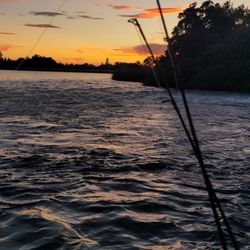
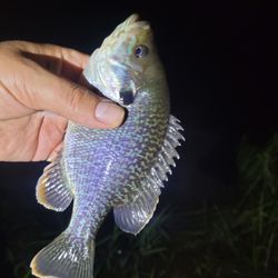
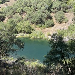
Campsite 22 is a double site. We were a group of 9 and it fit 5 tents comfortably (2 large family size, 2 medium, 1 small), and could have still fit another 2 tents. The sight had 2 picnic tables, 2 grills, and 1 fire pit. The bathroom was a close walk (under a minute) but not in view from the site. There was 2 water stations near, 1 being at the bathroom. All the bathrooms were very clean and maintained. The lake was less than a 5 minute walk from the campsite and there were multiple bathrooms on the way. We enjoyed a few hours at the lake each day. It was very clean and pretty. Bring water shoes as it's mostly rocks underneath. Everyone played in the water. We had floaties and tossed a football. Fortunately none of us got stung by the occasional wasp that came around every time we cooked but we did get bit a lot by the mosquitoes even though we wore repellent. We brought a netted canopy we put right over the picnic table and ate inside of it. This site had a good portion of shade with the sun draping in through the tall trees. We were able to enjoy most of the day without having to worry about sunscreen unless we went down to the water. Campsites are close together but we stayed during the week days following Labor Day weekend and only had a couple other campers who were not in view. Had we stayed during the weekend there definitely would had been people at the site right next to us very close in view and no doubt could hear everything. For that reason I would definitely not stay at this campground during a busy holiday weekend like Labor Day. Between the 9 of us we had 4 different cell providers and none of got service at all, not even walking around or at the lake. It was very nice to spend time with no one on their phones. The nearest store is about a 30 min drive. I wouldn't want to drive there at night as there's no light and lots of turns. Our site allowed 4 cars, we had 3. It was an amazing family camping trip and we will definitely go back and book site 22 again.

I have been camping here since I was little! It is still such a great campground. The campsites are very well maintained and the camp hosts that we have had these last few trips this summer have been awesome. We have a few more trips planned this year here and we are definitely looking forward to it!

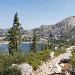
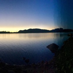
We stayed here in late June and had a wonderful camping experience. The campground was very clean. When we arrived our campsite had been raked and the fire pit cleaned out by the campground hosts. We did not experience any problems with noisy campers, loud radios, etc. The campground hosts cleaned the restrooms at least twice a day and were very friendly. The lake is walking distance from the campground and there is a very good paved path that leads down to the waterline making it easy to get your gear down to the water. The surface temperature of the lake was in the 70s and very comfortable to swim in. Of the two campgrounds on the lake (Shirttail and Giant Gamp), this was the quieter of the two. We camped here in a 38' motorhome and found the paved sites, roads and ample water connections adequate. If camping here in a large RV like ours, I recommend sites 3, 4, 5, 6, 22, 25, 29, 30 all of which are relatively level.

2 years ago
really nice area, no issues with any staff, clean bathrooms. Lake was a great temp and fire wood was a good price! Loved the scenery ! read more


6 years ago
We loved this place!! There weren't many people and the campsites are well spaced out. Ignore past reviews of bad camp host. I would guess this used to be privately owned but is now part of recreation.gov. You can walk to the lake to a nice rock beach. I wore water shoes but they aren't necessary in the water. The water is nice. Not super cold. We spent 7 hours at the lake! The toilets are basically outhouses. Come prepared to brush your teeth in nature. I will be returning here again. read more


3 years ago
Campsite 22 is a double site. We were a group of 9 and it fit 5 tents comfortably (2 large family size, 2 medium, 1 small), and could have still fit another 2 tents. The sight had 2 picnic tables, 2 grills, and 1 fire pit. The bathroom was a close walk (under a minute) but not in view from the site. There was 2 water stations near, 1 being at the bathroom. All the bathrooms were very clean and maintained. The lake was less than a 5 minute walk from the campsite and there were multiple bathrooms on the way. We enjoyed a few hours at the lake each day. It was very clean and pretty. Bring water shoes as it's mostly rocks underneath. Everyone played in the water. We had floaties and tossed a football. Fortunately none of us got stung by the occasional wasp that came around every time we cooked but we did get bit a lot by the mosquitoes even though we wore repellent. We brought a netted canopy we put right over the picnic table and ate inside of it. This site had a good portion of shade with the sun draping in through the tall trees. We were able to enjoy most of the day without having to worry about sunscreen unless we went down to the water. Campsites are close together but we stayed during the week days following Labor Day weekend and only had a couple other campers who were not in view. Had we stayed during the weekend there definitely would had been people at the site right next to us very close in view and no doubt could hear everything. For that reason I would definitely not stay at this campground during a busy holiday weekend like Labor Day. Between the 9 of us we had 4 different cell providers and none of got service at all, not even walking around or at the lake. It was very nice to spend time with no one on their phones. The nearest store is about a 30 min drive. I wouldn't want to drive there at night as there's no light and lots of turns. Our site allowed 4 cars, we had 3. It was an amazing family camping trip and we will definitely go back and book site 22 again. read more

16 years ago
12 years ago
5 years ago
8 years ago
6 years ago
I have been camping here since I was little! It is still such a great campground. The campsites are very well maintained and the camp hosts that we have had these last few trips this summer have been awesome. We have a few more trips planned this year here and we are definitely looking forward to it! read more


6 years ago
12 years ago
15 years ago
9 years ago
14 years ago
We stayed here in late June and had a wonderful camping experience. The campground was very clean. When we arrived our campsite had been raked and the fire pit cleaned out by the campground hosts. We did not experience any problems with noisy campers, loud radios, etc. The campground hosts cleaned the restrooms at least twice a day and were very friendly. The lake is walking distance from the campground and there is a very good paved path that leads down to the waterline making it easy to get your gear down to the water. The surface temperature of the lake was in the 70s and very comfortable to swim in. Of the two campgrounds on the lake (Shirttail and Giant Gamp), this was the quieter of the two. We camped here in a 38' motorhome and found the paved sites, roads and ample water connections adequate. If camping here in a large RV like ours, I recommend sites 3, 4, 5, 6, 22, 25, 29, 30 all of which are relatively level. read more

10 years ago
13 years ago
14 years ago
10 years ago
wonderful site, no showers on site. not unreasonably far from civilization...fairly priced... reserve your site ahead, most people do. read more


13 years ago
More info about Shirttail Creek
Foresthill, CA 95631
Directions
(530) 367-2224
Call Now
Visit Website
https://www.recreation.gov/camping/campgrounds/232887
Hours
Outdoor Amenities
Other Amenities
Ask the Community - Shirttail Creek
Is it still run by the same couple everyone appears to be upset over? Is there reception?
I believe it is but I didn't have a bad experience at all. No reception
Are there trees big enough to tie a hammock to at the campground?
I want to say yes. I would guess it depends on the site but there are lots of trees
Does anyone know if site 30 has one or two bear boxes?
I do not know about 30. But if it's any indicator, site 22 which was one of the big multi-family sites had two picnic tables and one bear box.
Review Highlights - Shirttail Creek
You might also consider


Why does Yelp recommend reviews?
2 reviews that are not currently recommended
The reviews below are not factored into the business's overall star rating.
11 years ago
8 years ago
Shirttail Creek - campgrounds - Updated August 2026
Best of Foresthill
People found Shirttail Creek by searching for…
Things to Do in Foresthill, CA
Fishing Spots in Foresthill, CA
Swimming Lakes in Foresthill, CA
Hiking Trails in Foresthill, CA
River Swimming in Foresthill, CA
Camping Sites in Foresthill, CA
Fly Fishing Shop in Foresthill, CA
Public Pools in Foresthill, CA
Water Parks for Kids in Foresthill, CA
Retreat Centers in Foresthill, CA
Crabbing Location in Foresthill, CA
Sauna and Steam Baths in Foresthill, CA
Kids Birthday Places in Foresthill, CA
Trending Searches in Foresthill, CA
Beautiful Views near Shirttail Creek
Blueberry Picking near Shirttail Creek
Campgrounds near Shirttail Creek
Cliff Jumping near Shirttail Creek
Crabbing Location near Shirttail Creek
Day Trips near Shirttail Creek
Dog Friendly Things To Do near Shirttail Creek
Fishing With Kids near Shirttail Creek
Flower Fields near Shirttail Creek
Jet Ski Rental near Shirttail Creek
Kayak Rental near Shirttail Creek
Kids Activities Indoor near Shirttail Creek
Long Term Rv Parking near Shirttail Creek
Lookout Points near Shirttail Creek
Outdoor Activities near Shirttail Creek
Parks For Parties near Shirttail Creek
Peach Picking near Shirttail Creek
Picnic Areas near Shirttail Creek
Picnic Spots near Shirttail Creek
Public Shower near Shirttail Creek
River Swimming near Shirttail Creek
Rock Quarry near Shirttail Creek
Scenic Drive near Shirttail Creek
Scenic Overlook near Shirttail Creek
Shopping Malls near Shirttail Creek
Sunrise View near Shirttail Creek
Surf Shop near Shirttail Creek
Swimming Holes near Shirttail Creek
Tackle Shop near Shirttail Creek
Things To Do On A Rainy Day near Shirttail Creek
Trailer Park near Shirttail Creek
Browse Nearby
BEST of Foresthill, California Hotels near Shirttail Creek
BEST of Foresthill, California Rv Parks near Shirttail Creek
BEST of Foresthill, California Coffee near Shirttail Creek
BEST of Foresthill, California Swimming Holes near Shirttail Creek
BEST of Foresthill, California Things to Do near Shirttail Creek
BEST of Foresthill, California Restaurants near Shirttail Creek
BEST of Foresthill, California Lakes near Shirttail Creek
BEST of Foresthill, California Bed & Breakfast near Shirttail Creek
Browse Brands
Related Cost Guides
Related Searches in Foresthill, CA
Affordable Kayak Rental Services in Foresthill, California
Affordable Lodging Options in Foresthill, California
Affordable Long Term RV Parking in Foresthill, California
Best Crabbing Locations to Visit in Foresthill, California
Best Fishing Locations and Guides in Foresthill, California
Best Nature Trails for Hiking in Foresthill, California
Best Places for Horseback Riding in Foresthill, California
Best Sightseeing Experiences Available in Foresthill, California
Book Top Fishing Trips in Foresthill, California Today
Book a Cozy Cabin Rental in Foresthill, California
Browse Charming Cabins in Foresthill, California
Browse Tent Camping Sites in Foresthill, California
Browse Top Hotels in Foresthill, California for Your Stay
Check Out Off Road Trails in Foresthill, California
Discover Dog Friendly Beaches Near Foresthill, California
Discover Dog Friendly Trails to Explore in Foresthill, California
Discover Easy Hiking Trails Near Foresthill, California
Discover Free Campgrounds in Foresthill, California Area
Discover Fun Toddler Parks in Foresthill, California for Your Little One
Discover Kid Friendly Hiking Trails in Foresthill, California
Discover Lakes & Ponds to Explore in Foresthill, California
Discover Popular Bike Trails in Foresthill, California
Discover Scenic Beach Camping Sites in Foresthill, California
Discover Scenic Mountain Bike Trails Near Foresthill, California
Discover Top Boat Tours in Foresthill, California for All Ages
Discover Top Fishing Lakes in Foresthill, California for Your Next Trip
Discover Top State Parks to Visit in Foresthill, California
Discover a Hiking Trail in Foresthill, California
Discover the Best Beaches in Foresthill, California
Discover the Best Fishing Lake in Foresthill, California
Discover the Best Night Hike Trails in Foresthill, California
Dog-Friendly Hikes With Dogs in Foresthill, California
Enjoy Camping Adventures Around Foresthill, California
Enjoy Fishing With Kids in Foresthill, California Safely
Enjoy Hiking Adventures in Foresthill, California
Enjoy Kayaking Adventures in Foresthill, California
Enjoy Off Leash Dog Hikes in Foresthill, California
Enjoy Sailing Adventures in Foresthill, California
Enjoy Scenic Places to Walk in Foresthill, California
Enjoy Tent Camping Spots Around Foresthill, California
Enjoy Water Activities and Fun in Foresthill, California
Enjoy a Beautiful Waterfall Hike in Foresthill, California
Enjoy the Best Picnic Spots and Ideas in Foresthill, California
Enjoy the Best Walking Trails in Foresthill, California
Experience Amazing Scuba Diving in Foresthill, California
Experience Thrilling White Water Rafting in Foresthill, California
Experienced Fishing Guides Available in Foresthill, California
Explore Beautiful Parks and Green Spaces in Foresthill, California
Explore Easy Hikes Perfect for All in Foresthill, California


