Stevens Trail Photos


You might also consider
More like Stevens Trail
Recommended Reviews - Stevens Trail
Start your review...

Reviews With Photos

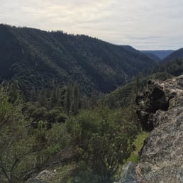
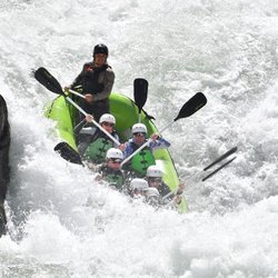
Back when I wanted to go for my first ever solo hike, I asked my friend Molly, who went hiking by herself all the time, if she knew of a good, well-populated trail to try. She said something to the effect of, "Steven's Trail is a little hard, but I think you can handle it." This trail has since become one of my favorites, and I've hiked it several dozen times now, sometimes alone, and sometimes with friends. Most recently, I came hiking here with someone who I was dating last summer/fall. I asked him if he was sure he could handle a moderately difficult 8 miles-- 4 miles down to the river, and 4 miles back up. "You keep thinking I'm not going to be able to keep up with you," he said. We packed up some fig jam, honey, and almond butter sandwiches, some Lara bars, vegan jerky, a few cans of Truly, and some Mary Jane, and headed out to Colfax. If you are hiking this trail for the first time, I would recommend picking a cooler day, if possible. We came out in October, so it wasn't terribly hot. The downside was that none of the waterfalls were running. The nice thing was that the river flow was so low that we could practically wade across it. In Spring, in a good year, the river can be raging. People go white water rafting not far from here. Also in Spring, you can find all kinds of wildflowers on this trail. Some of the ones I've seen include monkey flower, irises, succulents, thistle, Indian paintbrush, innocence, Sierra Nevada checkerbloom, poppies, and lupine, just to name a few. The waterfall usually flows in early Spring, and in a good year, can flow as late as early fall. It looks like a slow flow from far away, but up close, the waterfall on the hiking trail can be such a challenge to cross that many people just turn around. When the waterfall has a stronger flow, I prefer crossing it on the bike trail, which takes you to the same place, at about the same distance. On four different solo trips last year, all during different months, I happened upon two ladybug blooms, and two butterfly blooms. I was sitting in the middle of the creek with thousands of tiny purple butterflies swarming all around me. Unreal. There is a decent amount of parking at the trail head, but it usually fills up by 9am or so on a busy spring weekend. People start to leave by 11, so either come early, or come late. There is a bathroom at the trailhead, although I'd recommend going to Taco Bell or the grocery store across the freeway instead, if you can. That way, you can recharge on snacks at the same time. Speaking of fuel, if you are planning on hiking the whole trail, I would recommend lugging along at least 2 liters of water per person, or even more on a hot day. Overall, this is a fantastic trail. This time of year, the waterfalls and creeks should all be flowing, and there should be plenty of wildflowers and butterflies to see.


About a 50 minutes drive from sacramento. Very easy to get to. Get there early to get a parking spot. Note at the time I went (end of May), the bathroom was closed and taped off. There were some parts of the trail that were narrow and other requiring you to cross small streams. I would rate the hike intermediate to hard. There's plenty of shade and shelter but there's long stretches where you are exposed to direct sun. Weather forecast said 20 chance of precipitation so of course it poured. But the view was so worth it. Last time i went it snowed unexpectedly so be prepared for adventure!

Lots of trees/branches fell down. Take gloves and a change of clothes in the car with you. The trees/bushes grew out making part of a path harder to get thru. All thru paths: trees/branches fell down and may continue to fall during your hike, and shrubs have grown out towards the path deeper in the trail (1 to 1.5 hours hike towards waterfall). January: Our hike took us a little beyond the waterfall. We turned back at 1:30 to make it back before sun down. We always made a left turn at each fork. It was a good and hard hike due to fallen trees/branches (obstacle courses for us). It is a moderate or difficult hike at times (not for children who are novice hikers). Note: at a fork after the tee pee, the right fork with a moderate-difficult incline goes towards the shooting range area (there is no sign to note that). Don't go too far out! I don't know where the shooting range boundaries starts and ends. A friend heard shooting nearby the last time they took this route. One portable restroom at the parking lot. No trash bins, so people tend to leave some trash at the lot and along the trail before the tee pee. I agree with some yelpers on this site about the litter, please pick up after yourselves. Treat all places as you'd like others to treat your space.

Its approximately 7 to 8 miles round trip. One restroom at the parking lot, ZERO trash bins. The land management really need to address that. Important: you need to know that this is a hike DOWN to the river, which means you have to hike back UP. That being said, the hard part is coming back. I couldn't believe how many people were NOT carrying water going down. Which brings me to point number 2. You NEED to bring water for the way BACK, unless, you're gonna drink river water. Will you die without it? No, but it's gonna be very uncomfortable without it. It's pretty steep especially the last mile. I'd say about 30-40 % of this hike is in the shade depending on the time you go. Get their early...The very small parking lot only has about 19 parking spots then you need to park on the main road. We arrived at 0750 on a Sunday. Only 5 other vehicles there. When we got back to the car around 1045, not only was the lot full but there were at least, 50 cars parked on the road. This is a narrow trail and extremely narrow at some points so, passing can be annoying. There is plenty of poison oak so be mindful of that. I wouldn't TOUCH ANYONE'S DOG either, specifically due to the poison oak issue. Thousands of poppies and other wildflowers. Pretty views especially of the river. Looks like a great summer spot with rock jumps and plenty of places to hang out by the river. I'd never come here in the summer I can see it being a cluster f*ck. Already kinda was its the first week of April. When in doubt, stay left... until you get to the river. Not sure of a true ending to this hike.


STRENUOUS!!! Now I've gotten that out the way... did we have a great time? A-B-S-O-L-U-T-E-L-Y!!! Definitely NOT a Beginners hike! The trail was open but parking may be an issue if arrive after 7am. We got there about 630Am. And plenty of parking. Restroom is closed! - there is one dark cave which many others says that's a potty area if needed. We did not use it. WATER IS A MUST!!! Hiking poles(sticks) is preferable! Will help you on those steep inclines. The destination is the river. Takes about 4 miles in. When you see large rocks, that's it!!! Rest well, eat, drink h2o, capture the beauty because as the hike back you will cry for your mama! Ok maybe not you but I sure cried for someone! It was DEFINITELY LEG DAY!!! Amazing view of nature!!!

Unlike most of the reviewers of this trail, I am not super fit. I love to hike, but I am a big girl, 300 lbs yesterday morning per the scale when I left to do this hike. I am always looking for dog-friendly trails to take my little pup on and was excited to see Stevens trail allows dogs. When I read that it was a 9 mile round trip hike, I was a little worried but I have done 7 and 8 mile hikes before so I spent a few weeks walking every day before heading out to the trail to make sure I was ready..... I wasn't! I'm writing this review in the hopes that it will help YOU to be :) I read many Yelp reviews that the trail wasn't quite 9 miles, but I am here to say I walked until I couldn't walk any more and it is well over 9 miles if you do it all. There are lots of waterfalls and creeks to pass and once you reach "the end" you are literally just walking out on the rocks next to the river. I walked until swimming was the only other option and my app said 10.2 miles when I got back to my car. I think one of the great things about this hike is that it can be as long as you want it to be. I met many people on the trail who turned back after 2 miles or 3 miles and in hindsight, I wish I had as well. What I am saying is, this is YOUR hike, so make this trail the length you are comfortable with. I also read this was a dog friendly trail and that is true, for the most part. We met a dozen or so dogs on the first few miles of our hike but after the first narrow area of waterfall and cliffs, we only saw two more dogs and they were hiking together with a mother and her adult son. My girl is only 15 lbs but there were more 5 or 6 places throughout the hike where she had to be carried momentarily or we wouldn't have been able to continue. I was surprised how many narrow spots and quickly moving water areas she navigated on her own and maybe if I wasn't overprotective she could have done them all herself, but I just couldn't take the risk. I also spent more time then I would have liked worried she was going to fall off the narrow cliffside, so even though this trail is rated child and dog friendly, I won't bring her back and I certainly wouldn't bring small children. We saw one 10 year old boy with his father, but even they turned back at the first waterfall crossing where I had to pick up my dog. The people that did see her at the end of the hike kept calling her a "rockstar" and marvelled at what a trooper she was to have made it so far. Even after slathering myself with sunblock and insect repellant, I am absolutely covered in mosquito bites today. My count thus far is at 53 bites. My husband has dozens of bites as well and even our poor pup has bites on her tummy. Also, because I knew the temps would be in the 80's, I made sure to cover myself from neck to toes but those pesky buggers bit right through my clothes. By the end, we were being followed by swarms of mosquitos but to be fair, that was much later in the day, closer to 5 p.m. In the morning, we hardly noticed the bugs. You really need: - a hat to keep the sun off you in the long sections without shade, - good shoes with thick soles so that when you're stepping down of sharp rocks you don't bruise your feet and something that is anti-slip would be ideal because you will be crossing watery sections with slippery rocks. Your feet will get wet! - Sunblock and bug-spray are a must! - And LOTS of water. We brought 4 bottles of water per person and it wasn't enough. Many of the reviews make it clear that since you are heading down to the river gradually, you must be aware that while the first portion of the trek is downhill, the way back is uphill, so you must be prepared for the hardest part of the hike to be the end. Even with that in mind as I set out, I was really not prepared for the steep incline I would be facing. I won't lie; I died. It was only once, but it happened. I laid on a rock for about 15 minutes and my poor hubby and pup sat patiently waiting for me. I am more sore today than I have been in a long time, but hey, I made it and I am proud of myself! If I can do it, you can do it! All of that being said, this is a beautiful hike. The views are gorgeous. There were wildflowers and butterflies everywhere. We saw lots of lizards (which my doggie loved to chase) and multiple snakes. There were tons of birds and interesting insects. The river was clear and cool and great for soaking our feet. I know it seems like this review has been somewhat negative but for me this is a 4 star hike, even with all its challenges. I just wish I had been more prepared. I genuinely hope this information will help someone else to be. Happy Hiking everyone!

Gorgeous hike with lots of little side trails to hike down to get into the water. I would recommend going earlier in the morning since the weather is warming up and getting hot in the afternoons, and bring enough water and a light lunch. Went on a Monday during quarantine and the trail was pretty empty, not sure how it is on the weekends but would definitely recommend

Great hike! It's dog friendly and parking is free. The trail is about 7 min and is well shaded with varying scenery. You start under the trees then you overlook the American river and later you get to the bottom where you can sit, take a break, enjoy dipping your feet in the cool water and then backtrack. I recommend bringing a hat, good shoes (there are water streams you can slip on), lots of water and some snacks. Happy hiking!

Easy??? Not quite. Easy, is what my Hiking App rated Stevens Trail. With so many upgrades and downgrades, I consider this trail to be more moderate. We got here and hiked about six miles round trip. It's about four and a half miles to the river but we didn't get there. Although we didn't get to the river, there were so many different things to catch your attention. It was my second time here and the first time I tried this trail, I ran across a huge rattlesnake. That was the end of that trip. This time, I ran across several snakes but no rattlesnakes! This is an easy to find hiking area, right off the highway. There's a small, free parking lot which gets filled quickly. I hike often and I have to say this was a strenuous hike, with different types of terrain, from dirt trails, to rocky ones. Some parts of the trail is for one person to get by and I found myself hugging the earth so a hiker could go by. Hubs helped a group of ladies cross the trail which went directly through the gushing fall. Hence, this is not an easy hike. I think this trail should be considered moderate in difficulty. I'm no couch potato, maybe I'm a Prima Donna, but I found myself short winded in some parts. Although it's challenging, the views are surely worth every step!

We headed out at 5am to do this hike. We also made sure to bring a lot of fluids because this trail is known to be a hot one that drains your hydration. There is little to no shade. This is a long trail so be prepared. It was suppose to be a 9 mile hike but we had to cut our hike short to 7 miles because we kind of went off the trail then we had to deal with a dingleberry of a woman who had her dog off the leash and the poor dog took off running so we decided to return her dog to her which was 30 to 40 minutes of chaos....smh...not the poor dog's fault. This trail is very narrow and steep at various point of the hike. So people who are afraid of heights be prepared. This trail also has a ton of mosquitoes so bring bug repellent. For the most part this trail has beautiful breathtaking views! We will definitely be back to finish what we started.
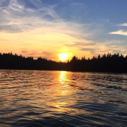
Stevens Trail is such an amazing hike once you get to the very end of the trail with all the rocks to climb and the river running. I have to admit, I thought it was never going to end! I kept asking to myself, "How much longer?" " Is this the end?" Luckily with the reception we had we were able to see where we were at the trail with our little red dot on the map. The longest and seemingly never ending trail is when we were on the side of the mountain looking down at the cliff of rocks and trees. We went on this trail in March and there were many bright blue butterflies flying everywhere. While walking the trail there are a few spots with shade and coolness, take advantage of the shade when approaching it to take a break on some water and snacks. I read quiet a few reviews where people said to be aware of poison ivy, so i wore thick leggings and long sleeves to just be safe. I also wore minimus running shoes so that it would have good traction when walking up rocks. I would not suggest Nike Rosches as those don't have any grip. There is an old miners cave that some people go in to but i did not because i was too afraid. The cave is short in height where one woul dhave to hunch down and walk in to it. It is pretty dark. I suggest this hike because it is not a continuous incline or decline, it is a mixture of incline and decline the entire way. I also suggest to go early in the morning so that it won't get too hot. Many people bring their dogs along this hike. It took us 5 hrs to finish the hike roundtrip and it is about 8 miles. We only stop for maybe a total of 20 minutes to rest in total. Everyone has to go at least once if one wants to go on a good hike!

2 months ago
It was a great hike, sadly it was raining but we still got to mile 3 before heading back. On the hike I lost my great grandmothers bracelet that I haven't taken off in years. If anyone hiking this trail is willing, I would deeply appreciate if you would look for it and return it to me. I could meet you anywhere within an hour of Sacramento to retrieve it from you. I'll attach a picture of it along with a picture of me on the hike and my email. To the person who finds it, I'll give you a $20 reward, cash (or if you are willing to mail it, that would be even better) My email is duncansophia@icloud.com read more


4 months ago
The hike was actually a really good workout. A lot of hills, creeks, and different plant life. I thought it was a good challenge but not impossible. At the same time I'm not a big hiker. We did come across a friendly group of 70 yo ladies that had completed the trail a few times and gave a lot of information. read more


1 year ago
Steven's Trail is about 8 mile out-and-back trail near Colfax, California. The trail will be along the northwestern slope of the North Fork of the American River Canyon. This trail is well maintained and naturally beautiful but a bit challenging. It took me about 4 hours to complete. Parking is limited, so be patience, especially on the weekends. To get to Stevens Trail: Follow I-80 East towards the town of Colfax and exit at North Canyon Way. Travel along North Canyon Way for about a mile. Go past the Colfax cemetery to the Stevens Trailhead. Parking will be on your left. There's a cool cave! Exploring it and you may find yourself having a blast. Garbage in. Garbage out. Please keep the trail pristinely clean. Enjoy! read more


4 years ago
Back when I wanted to go for my first ever solo hike, I asked my friend Molly, who went hiking by herself all the time, if she knew of a good, well-populated trail to try. She said something to the effect of, "Steven's Trail is a little hard, but I think you can handle it." This trail has since become one of my favorites, and I've hiked it several dozen times now, sometimes alone, and sometimes with friends. Most recently, I came hiking here with someone who I was dating last summer/fall. I asked him if he was sure he could handle a moderately difficult 8 miles-- 4 miles down to the river, and 4 miles back up. "You keep thinking I'm not going to be able to keep up with you," he said. We packed up some fig jam, honey, and almond butter sandwiches, some Lara bars, vegan jerky, a few cans of Truly, and some Mary Jane, and headed out to Colfax. If you are hiking this trail for the first time, I would recommend picking a cooler day, if possible. We came out in October, so it wasn't terribly hot. The downside was that none of the waterfalls were running. The nice thing was that the river flow was so low that we could practically wade across it. In Spring, in a good year, the river can be raging. People go white water rafting not far from here. Also in Spring, you can find all kinds of wildflowers on this trail. Some of the ones I've seen include monkey flower, irises, succulents, thistle, Indian paintbrush, innocence, Sierra Nevada checkerbloom, poppies, and lupine, just to name a few. The waterfall usually flows in early Spring, and in a good year, can flow as late as early fall. It looks like a slow flow from far away, but up close, the waterfall on the hiking trail can be such a challenge to cross that many people just turn around. When the waterfall has a stronger flow, I prefer crossing it on the bike trail, which takes you to the same place, at about the same distance. On four different solo trips last year, all during different months, I happened upon two ladybug blooms, and two butterfly blooms. I was sitting in the middle of the creek with thousands of tiny purple butterflies swarming all around me. Unreal. There is a decent amount of parking at the trail head, but it usually fills up by 9am or so on a busy spring weekend. People start to leave by 11, so either come early, or come late. There is a bathroom at the trailhead, although I'd recommend going to Taco Bell or the grocery store across the freeway instead, if you can. That way, you can recharge on snacks at the same time. Speaking of fuel, if you are planning on hiking the whole trail, I would recommend lugging along at least 2 liters of water per person, or even more on a hot day. Overall, this is a fantastic trail. This time of year, the waterfalls and creeks should all be flowing, and there should be plenty of wildflowers and butterflies to see. read more


About a 50 minutes drive from sacramento. Very easy to get to. Get there early to get a parking spot. Note at the time I went (end of May), the bathroom was closed and taped off. There were some parts of the trail that were narrow and other requiring you to cross small streams. I would rate the hike intermediate to hard. There's plenty of shade and shelter but there's long stretches where you are exposed to direct sun. Weather forecast said 20 chance of precipitation so of course it poured. But the view was so worth it. Last time i went it snowed unexpectedly so be prepared for adventure! read more


1 year ago
4 years ago
Lots of trees/branches fell down. Take gloves and a change of clothes in the car with you. The trees/bushes grew out making part of a path harder to get thru. All thru paths: trees/branches fell down and may continue to fall during your hike, and shrubs have grown out towards the path deeper in the trail (1 to 1.5 hours hike towards waterfall). January: Our hike took us a little beyond the waterfall. We turned back at 1:30 to make it back before sun down. We always made a left turn at each fork. It was a good and hard hike due to fallen trees/branches (obstacle courses for us). It is a moderate or difficult hike at times (not for children who are novice hikers). Note: at a fork after the tee pee, the right fork with a moderate-difficult incline goes towards the shooting range area (there is no sign to note that). Don't go too far out! I don't know where the shooting range boundaries starts and ends. A friend heard shooting nearby the last time they took this route. One portable restroom at the parking lot. No trash bins, so people tend to leave some trash at the lot and along the trail before the tee pee. I agree with some yelpers on this site about the litter, please pick up after yourselves. Treat all places as you'd like others to treat your space. read more

 - Hiking Near Me - Colfax, California")

5 years ago
Its approximately 7 to 8 miles round trip. One restroom at the parking lot, ZERO trash bins. The land management really need to address that. Important: you need to know that this is a hike DOWN to the river, which means you have to hike back UP. That being said, the hard part is coming back. I couldn't believe how many people were NOT carrying water going down. Which brings me to point number 2. You NEED to bring water for the way BACK, unless, you're gonna drink river water. Will you die without it? No, but it's gonna be very uncomfortable without it. It's pretty steep especially the last mile. I'd say about 30-40 % of this hike is in the shade depending on the time you go. Get their early...The very small parking lot only has about 19 parking spots then you need to park on the main road. We arrived at 0750 on a Sunday. Only 5 other vehicles there. When we got back to the car around 1045, not only was the lot full but there were at least, 50 cars parked on the road. This is a narrow trail and extremely narrow at some points so, passing can be annoying. There is plenty of poison oak so be mindful of that. I wouldn't TOUCH ANYONE'S DOG either, specifically due to the poison oak issue. Thousands of poppies and other wildflowers. Pretty views especially of the river. Looks like a great summer spot with rock jumps and plenty of places to hang out by the river. I'd never come here in the summer I can see it being a cluster f*ck. Already kinda was its the first week of April. When in doubt, stay left... until you get to the river. Not sure of a true ending to this hike. read more

5 years ago
3 years ago
Worth. The. Miles. Take lots of water. 60° and felt like 80+. Nonetheless, one of my fav trails ever. read more


6 years ago
STRENUOUS!!! Now I've gotten that out the way... did we have a great time? A-B-S-O-L-U-T-E-L-Y!!! Definitely NOT a Beginners hike! The trail was open but parking may be an issue if arrive after 7am. We got there about 630Am. And plenty of parking. Restroom is closed! - there is one dark cave which many others says that's a potty area if needed. We did not use it. WATER IS A MUST!!! Hiking poles(sticks) is preferable! Will help you on those steep inclines. The destination is the river. Takes about 4 miles in. When you see large rocks, that's it!!! Rest well, eat, drink h2o, capture the beauty because as the hike back you will cry for your mama! Ok maybe not you but I sure cried for someone! It was DEFINITELY LEG DAY!!! Amazing view of nature!!! read more


Unlike most of the reviewers of this trail, I am not super fit. I love to hike, but I am a big girl, 300 lbs yesterday morning per the scale when I left to do this hike. I am always looking for dog-friendly trails to take my little pup on and was excited to see Stevens trail allows dogs. When I read that it was a 9 mile round trip hike, I was a little worried but I have done 7 and 8 mile hikes before so I spent a few weeks walking every day before heading out to the trail to make sure I was ready..... I wasn't! I'm writing this review in the hopes that it will help YOU to be :) I read many Yelp reviews that the trail wasn't quite 9 miles, but I am here to say I walked until I couldn't walk any more and it is well over 9 miles if you do it all. There are lots of waterfalls and creeks to pass and once you reach "the end" you are literally just walking out on the rocks next to the river. I walked until swimming was the only other option and my app said 10.2 miles when I got back to my car. I think one of the great things about this hike is that it can be as long as you want it to be. I met many people on the trail who turned back after 2 miles or 3 miles and in hindsight, I wish I had as well. What I am saying is, this is YOUR hike, so make this trail the length you are comfortable with. I also read this was a dog friendly trail and that is true, for the most part. We met a dozen or so dogs on the first few miles of our hike but after the first narrow area of waterfall and cliffs, we only saw two more dogs and they were hiking together with a mother and her adult son. My girl is only 15 lbs but there were more 5 or 6 places throughout the hike where she had to be carried momentarily or we wouldn't have been able to continue. I was surprised how many narrow spots and quickly moving water areas she navigated on her own and maybe if I wasn't overprotective she could have done them all herself, but I just couldn't take the risk. I also spent more time then I would have liked worried she was going to fall off the narrow cliffside, so even though this trail is rated child and dog friendly, I won't bring her back and I certainly wouldn't bring small children. We saw one 10 year old boy with his father, but even they turned back at the first waterfall crossing where I had to pick up my dog. The people that did see her at the end of the hike kept calling her a "rockstar" and marvelled at what a trooper she was to have made it so far. Even after slathering myself with sunblock and insect repellant, I am absolutely covered in mosquito bites today. My count thus far is at 53 bites. My husband has dozens of bites as well and even our poor pup has bites on her tummy. Also, because I knew the temps would be in the 80's, I made sure to cover myself from neck to toes but those pesky buggers bit right through my clothes. By the end, we were being followed by swarms of mosquitos but to be fair, that was much later in the day, closer to 5 p.m. In the morning, we hardly noticed the bugs. You really need: - a hat to keep the sun off you in the long sections without shade, - good shoes with thick soles so that when you're stepping down of sharp rocks you don't bruise your feet and something that is anti-slip would be ideal because you will be crossing watery sections with slippery rocks. Your feet will get wet! - Sunblock and bug-spray are a must! - And LOTS of water. We brought 4 bottles of water per person and it wasn't enough. Many of the reviews make it clear that since you are heading down to the river gradually, you must be aware that while the first portion of the trek is downhill, the way back is uphill, so you must be prepared for the hardest part of the hike to be the end. Even with that in mind as I set out, I was really not prepared for the steep incline I would be facing. I won't lie; I died. It was only once, but it happened. I laid on a rock for about 15 minutes and my poor hubby and pup sat patiently waiting for me. I am more sore today than I have been in a long time, but hey, I made it and I am proud of myself! If I can do it, you can do it! All of that being said, this is a beautiful hike. The views are gorgeous. There were wildflowers and butterflies everywhere. We saw lots of lizards (which my doggie loved to chase) and multiple snakes. There were tons of birds and interesting insects. The river was clear and cool and great for soaking our feet. I know it seems like this review has been somewhat negative but for me this is a 4 star hike, even with all its challenges. I just wish I had been more prepared. I genuinely hope this information will help someone else to be. Happy Hiking everyone! read more


Gorgeous hike with lots of little side trails to hike down to get into the water. I would recommend going earlier in the morning since the weather is warming up and getting hot in the afternoons, and bring enough water and a light lunch. Went on a Monday during quarantine and the trail was pretty empty, not sure how it is on the weekends but would definitely recommend read more

2 years ago
Great hike! It's dog friendly and parking is free. The trail is about 7 min and is well shaded with varying scenery. You start under the trees then you overlook the American river and later you get to the bottom where you can sit, take a break, enjoy dipping your feet in the cool water and then backtrack. I recommend bringing a hat, good shoes (there are water streams you can slip on), lots of water and some snacks. Happy hiking! read more


Easy??? Not quite. Easy, is what my Hiking App rated Stevens Trail. With so many upgrades and downgrades, I consider this trail to be more moderate. We got here and hiked about six miles round trip. It's about four and a half miles to the river but we didn't get there. Although we didn't get to the river, there were so many different things to catch your attention. It was my second time here and the first time I tried this trail, I ran across a huge rattlesnake. That was the end of that trip. This time, I ran across several snakes but no rattlesnakes! This is an easy to find hiking area, right off the highway. There's a small, free parking lot which gets filled quickly. I hike often and I have to say this was a strenuous hike, with different types of terrain, from dirt trails, to rocky ones. Some parts of the trail is for one person to get by and I found myself hugging the earth so a hiker could go by. Hubs helped a group of ladies cross the trail which went directly through the gushing fall. Hence, this is not an easy hike. I think this trail should be considered moderate in difficulty. I'm no couch potato, maybe I'm a Prima Donna, but I found myself short winded in some parts. Although it's challenging, the views are surely worth every step! read more


5 years ago
We headed out at 5am to do this hike. We also made sure to bring a lot of fluids because this trail is known to be a hot one that drains your hydration. There is little to no shade. This is a long trail so be prepared. It was suppose to be a 9 mile hike but we had to cut our hike short to 7 miles because we kind of went off the trail then we had to deal with a dingleberry of a woman who had her dog off the leash and the poor dog took off running so we decided to return her dog to her which was 30 to 40 minutes of chaos....smh...not the poor dog's fault. This trail is very narrow and steep at various point of the hike. So people who are afraid of heights be prepared. This trail also has a ton of mosquitoes so bring bug repellent. For the most part this trail has beautiful breathtaking views! We will definitely be back to finish what we started. read more


5 years ago
10 years ago
Stevens Trail is such an amazing hike once you get to the very end of the trail with all the rocks to climb and the river running. I have to admit, I thought it was never going to end! I kept asking to myself, "How much longer?" " Is this the end?" Luckily with the reception we had we were able to see where we were at the trail with our little red dot on the map. The longest and seemingly never ending trail is when we were on the side of the mountain looking down at the cliff of rocks and trees. We went on this trail in March and there were many bright blue butterflies flying everywhere. While walking the trail there are a few spots with shade and coolness, take advantage of the shade when approaching it to take a break on some water and snacks. I read quiet a few reviews where people said to be aware of poison ivy, so i wore thick leggings and long sleeves to just be safe. I also wore minimus running shoes so that it would have good traction when walking up rocks. I would not suggest Nike Rosches as those don't have any grip. There is an old miners cave that some people go in to but i did not because i was too afraid. The cave is short in height where one woul dhave to hunch down and walk in to it. It is pretty dark. I suggest this hike because it is not a continuous incline or decline, it is a mixture of incline and decline the entire way. I also suggest to go early in the morning so that it won't get too hot. Many people bring their dogs along this hike. It took us 5 hrs to finish the hike roundtrip and it is about 8 miles. We only stop for maybe a total of 20 minutes to rest in total. Everyone has to go at least once if one wants to go on a good hike! read more


5 years ago
This is my husband's favorite hike. It is about 9 miles if you go all the way to the river and back. It is strenuous at times. It's very hot in the summer because it's in direct sun. Several places can be slippery in the fall and winter. This is a beautiful hike but know that it is a lot of up hill on the way back out. read more

This trail will take you a good 4 hours if you're going at a "decent pace." It's not the most beautiful of hikes, but it's pretty awesome for this area where you can see the river carve through the mountains. I would recommend starting as early in the morning as possible because a 90% the trail does not have shade. Also, the parking lot can get full fast so that's another big reason to come early. The end of the trail is somewhat unclear--you'll be at the river but the trail continues a little more along the river past/over some big rocks. I think most people stop where there's a fire pit which is basically the end. The iPhone app I was using (Gaia GPS) let me know where the actual end of the trail was. It's not the end of the world if you missed the very end. Speaking of the actual end, you'll get a great picture of the slow-moving river with a backdrop of tree-laden mountains flanking the open sky. If you're there at the right time, the lighting will make the moment better. Beware of the bugs. Like any hike ever, don't forget to pack water and sun screen/protection. It's really not that difficult of a trail. Lots of people run this trail since there aren't that many technical things you need to do. There are parts dedicated for mountain bikes as well. Again, not the best trail and not really worth going to unless you're in the area--but it's a good calorie burner and close enough if you don't want to travel too far from civilization. read more


6 years ago
Beautiful trail with some shaded areas; this is an intermediate hike, that rewards you with picturesque views of the American River. Parking is free, recommend taking plenty of water and a lunch. read more


3 years ago
I've hiked/trail ran Stevens trail at least 100 times and am just NOW writing a review. It's a great trail year round because it's always accessible(unless a rockslide is blocking the trail like it did right past the cave a few years ago). Don't have to worry about snow. During the cold months the river runs calmly and there's ladybugs who love to hibernate on the bush branches when you've reached the bottom of the trail. In the summer the water is extremely refreshing to swim in and admire, because it's crystal clear.. you can see the fish below :) Sorry to burst everyone's bubble but it's not a 9 mile hike. It's just under 8 I believe. I've tracked it numerous times. The mileage sign to the river is either A. Inaccurate or b. Measuring a part of the trail no longer accessible or c. I've been going the wrong way for all these years lol It gets hot. I worry about the people who start late. Always be prepared and bring lots of water. The way down seems like your jamming!!! Till you realize you'll be taking the same way back up! And it's steep. But very doable. There are some cliffs and drop offs, I'd keep small children on a short leash. The wildflowers during this time of year are ridiculous. But I go too early in the morning before the poppys open :( My dogs love it here. But I don't love the ticks that get on them since I let them off leash :( I thoroughly check them leaving the ticks at Stevens before putting them back in the car. I've never seen a rattle snake (thank fucking god). Never got a rash from the poison oak either. My dogs brush up against it each time for sure. They get a deep wash when we get home and so does everything I was wearing. Definitely check out Steve's trail. Running it every weekend along with other cross training will fully prepare you for a half marathon. And last but not least, pack it in, pack it out please(this includes human feces and toilet paper!!!) It seems to be getting more trashed over the years. read more
 - Hiking Near Me - Colfax, California")


Stevens Trail is one of my favorites if not THE favorite. I went last month on a Saturday with a friend, and the wildflowers were out! You'll see about 10 different flowers if not more. It was so beautiful.. The path is situated alongside a mountain, so be prepared if you are afraid of heights. However, the view that you get of the American River, valley, and mountains is breathtaking. There is one tougher crossing which is near the beginning; you cross over a small waterfall, and the path is pretty narrow. I'm glad that I have my waterproof hiking boots. I think people also tend to turn back around when the trail reaches the river crossing. To get across, you'll have to cross over a fallen tree trunk, but it's not very long. I was deathly afraid of falling into the river, but even I made it across. You'll end up at the big boulders alongside the river, so this is where we ate our lunch at. NOTES: -There is one bathroom which is in the parking lot. -Near the beginning, you'll be heading up a wider dirt path and then the ground levels out. There is one trail to your right that shoots up a hill, but the trail that you want to take continues onward. Don't make the same mistake that I did by going to the right; you'll end up on private property where some people may be target-shooting (oops). If you somehow end up on the road, turn around and head all the way back. -For a good portion of the hike, you will be exposed to the sun, so make sure to wear sunscreen and bring ample water. -Like many other reviewers noted, there is an old mining cave. It's not very long, but I was probably stupid for going all the way down the main channel. Go in at your own risk. -Lastly, remember to pack it out and even pack out trash that you find on the trail! read more


3 years ago
3 years ago
Came to this trail with my sister on Father's Day. It was very easy to follow and gives great views of the river..make sure you come prepared on this trail as it is rather long and is a mix of shaded & direct sun light depending on where you're at. Bring sun screen, water, snacks and dress accordingly. Come early to make sure you get a parking spot. ..also you will see cars lined up on the side of the road but drive down all the way to the end & you might get lucky to park inside the parking lot like we were. There are a few beautiful waterfalls & look outs along the way, you will see a lot of butterflies & lizards. It's just a good time! Only downside was there were a lot of people who's dogs were off the leash which I love dogs but just means I cant bring mine because I dont like risking random dogs just running up on us. read more


We discovered this gem of a hiking trail about a year ago, and frequent it often. We go pretty much everywhere as a family, so we have hiked this trail on several occasions with our 5 year old son and 8 year old daughter. I wouldn't call ourselves outdoor enthusiast to the point that our children are any different than any others, but we do a lot of things outdoors and our children have performed this hike with minimal complaining or difficulties. I wouldn't recommend it in the dead of summer without a ton of water, the uphill on the way out is a doozie! My favorite time of year to do this hike is in the fall and on warmer winter days, but be careful doing this alone, the unpredictable winter weather could create flash flooding and make the trail difficult to exit safely. Ok, now that that's out of the way this hike is beautiful and offers a great work out. The beginning of the hike offers shade trees and streams. Once you are out of the clearing of the shade trees you walk downhill adjacent to the "Old Chinese Wall" that was built by immigrant Chinese railroad workers, you can see it up on the top of the mountain to your left. You meander through switch backs and by water falls, there is even some abandoned mines. Watch out for the plentiful poison oak and take care crossing the waters from the waterfalls, this is more difficult in the winter and summer months. Once to the river's bottom, you can enjoy swimming in the crystal clean water of the American River. Some people even pack down tents and stay the night. Overall a great and beautiful hike that offers the relief of a nice swim on summer days, pack lots of water and don't go alone. I would also recommend looking up the trails historical information, it makes the hike seem magical. read more


4 years ago
7 years ago
Love! Love! Love! Beautiful trail with a view & waterfalls! Definitely bring snacks & lots of water if hiking the whole way. If you don't hike very often this might not be the easiest for you! read more


6 years ago
This is a difficult trail for the inexperienced/unprepared hiker. Not a good idea for young children. Lots of down hill which eventually become an uphill battle on the way back. It gets pretty hot and a good portion of the trail does not have shade or very little shade. I noticed a lot of what looks like poison oak sticking into the trails so avoid touching the vegetation if possible. I tried my best but with fatigue, I think I still managed to brush up on some. Will find out here shortly =(. YOU MUST BE WELL HYDRATED before the hike and BRING LOTS OF WATER!!! I repeat, YOU MUST BE WELL HYDRATED and BRING LOTS OF WATER. The trail is nearly 10 miles round trip and not very forgiving. There's even a warning sign at the beginning of the trail. No joke, you'll be sorry if you ignore it. The scenery is very beautiful but will cost you. And I'm not talking about money. Go prepared and enjoy. Oh and leave the kiddos at home unless they are experienced. read more

9 years ago
This hiking trail is great!! I wouldn't recommend to the parents of young kids to go here though, it is definitely for more experienced hikers, this is the best time of year to go minus the poison oak. Lol ... the hike is pretty epic and it took my daughter and I about 4-4.5 hours to complete, we hiked to the river and was pretty astounded by the views from the trail. About 1/3 of the way there is a beautiful waterfall, we got there pretty early in the morning and did not come across a lot of people which is nice. The hike is moderate going down to the river but coming back is where it gets ya, my calves and quads were sore for a few days after, hahaha, if you decide to hike this I definitely recommend to take water/camelback, and maybe a little snack if you decide to go the whole trail. I will definitely hike this trail again. read more


9 years ago
Overall, my mom and I loved the trail and would definitely hike again! It is very easy to get lost as there are not many signs, especially on the later part of the trail. There are a few different routes you can take to get to the river so pay attention to your surroundings and take note of the little details. Tips: - Water, sunscreen, and food are definitely a must. - Trails can get pretty narrow and VERY rocky so make sure you have durable shoes with a good grip. -Parking lot was full at 10am on a Saturday but there is parking on the side of the street. -Poison oak is everywhere but easy to maneuver around. - It may Be a good idea to bring water shoes if you plan on getting to the shore of the river. The current is very strong so keep that in mind. -There are gas stations and restaurants near the trail (Beach Hut Deli, Taco Bell, etc). Hope you enjoy it as much as I did! read more


9 years ago
This hike was fabulous for a Sunday funday. A bit tricky to navigate, as trail was lacking signage. We hiked approximately 9 miles with several breathtaking views along the way. I would opt out of taking my 6 year old on this hike, as it is a bit long and there are some gnarly cliffs. My water bottle decided it was suicidal and took a dive off of a cliff; RIP. 10/10 recommend. read more

If you have the chance, do NOT miss out on this trail. It is absolutely incredible for how close it is to Sacramento. The views are insanely beautiful. You are up high for a majority so if heights are an issue I would not go on this hike. Dogs are allowed but I think my dog would have been scared trying to cross the areas where there are rocks and the water flows. My biggest tip, if you are hiking around winter time is to make it near the end of the trail. There are clusters of thousands of hibernating last bugs on the trees and it is such a cool and interesting thing to witness. And if you are hiking in the winter make sure you go out early enough to get back before it gets dark. read more


8 years ago
I love this trail! Very convenient easy access from the freeway but 3 minutes in you can't hear a thing. So many wild flowers in the spring. Waterfalls and little streams all along the trail leading down to the river. read more

Page 1 of 3
More info about Stevens Trail
I - 80 E
Colfax, CA 95713
Directions
Hours
Indoor Amenities
Outdoor Amenities
Ask the Community - Stevens Trail
Where is the trailhead?
DIRECTIONS: Follow I-80 East towards the town of Colfax and exit at North Canyon Way. Travel along North Canyon Way for about a mile. Go past the Colfax cemetery to the… Read more
Review Highlights - Stevens Trail
You might also consider


Why does Yelp recommend reviews?
7 reviews that are not currently recommended
The reviews below are not factored into the business's overall star rating.
6 years ago
4 years ago
10 years ago
8 years ago
4 years ago
3 years ago
6 years ago
Stevens Trail - hiking - Updated June 2026
Best of Colfax
People found Stevens Trail by searching for…
Swimming Holes in Colfax, California
Hiking Trails With Waterfalls in Colfax, California
Things to Do in Colfax, California
Campgrounds in Colfax, California
Scenic View in Colfax, California
Places to Take Pictures in Colfax, California
Rock Climbing in Colfax, California
Dog Friendly Hiking Trails in Colfax, California
Secret Spots in Colfax, California
Scenic Drive in Colfax, California
Dog Friendly Beaches in Colfax, California
River Swimming in Colfax, California
Gold Panning in Colfax, California
Off Road Trails in Colfax, California
Fun Things to Do With Kids in Colfax, California
Natural Hot Springs in Colfax, California
Mountain Bike Trails in Colfax, California
Trending Searches in Colfax, CA
Black Owned Nail Salons near Stevens Trail
Boat Rental near Stevens Trail
Cliff Jumping near Stevens Trail
Dog Friendly Trails near Stevens Trail
Fishing Spots near Stevens Trail
Free Kids Activities near Stevens Trail
Jet Ski Rental near Stevens Trail
Lakes & Ponds near Stevens Trail
Off Road Trails near Stevens Trail
Outdoor Activities near Stevens Trail
Pick Your Own Farms near Stevens Trail
Places To Walk Around near Stevens Trail
Public Shower near Stevens Trail
Rock Quarry near Stevens Trail
Scenic Drive near Stevens Trail
Scenic Night View near Stevens Trail
Secluded Spots near Stevens Trail
Soccer Store near Stevens Trail
Strawberry Picking near Stevens Trail
Sunrise View near Stevens Trail
Swimming Holes near Stevens Trail
Swimming Lakes near Stevens Trail
Swimming Pools near Stevens Trail
Watch Sunset near Stevens Trail
Browse Articles
Browse Nearby
BEST of Colfax, California Coffee near Stevens Trail
BEST of Colfax, California Restaurants near Stevens Trail
BEST of Colfax, California Things to Do near Stevens Trail
BEST of Colfax, California Walking Trails near Stevens Trail
BEST of Colfax, California Sledding near Stevens Trail
BEST of Colfax, California Parks near Stevens Trail
BEST of Colfax, California Breakfast near Stevens Trail
Browse Brands
Related Searches in Colfax, CA
Affordable Kayak Rental Services in Colfax, California
Best Fishing Locations and Guides in Colfax, California
Best Nature Trails for Hiking in Colfax, California
Best Places for Horseback Riding in Colfax, California
Best Sledding Spots and Fun in Colfax, California
Best Waterfalls and Swimming Holes in Colfax, California
Check Out Off Road Trails in Colfax, California
Discover Dog Friendly Trails to Explore in Colfax, California
Discover Kid Friendly Hiking Trails in Colfax, California
Discover Scenic Mountain Bike Trails Near Colfax, California
Discover Scenic Waterfall Spots in Colfax, California
Discover Top Nature Parks to Visit in Colfax, California
Discover a Hiking Trail in Colfax, California
Discover the Best Night Hike Trails in Colfax, California
Enjoy Camping Adventures Around Colfax, California
Enjoy Exciting Mountain Biking Adventures in Colfax, California
Enjoy Tent Camping Spots Around Colfax, California
Enjoy a Beautiful Waterfall Hike in Colfax, California
Enjoy the Best Picnic Spots and Ideas in Colfax, California
Enjoy the Best Walking Path in Colfax, California
Enjoy the Best Walking Trails in Colfax, California
Exciting Cliff Jumping Spots in Colfax, California
Experience Thrilling White Water Rafting in Colfax, California
Explore Beautiful Parks and Green Spaces in Colfax, California
Explore Easy Hikes Perfect for All in Colfax, California
Explore Fun Activities to Do in Colfax, California
Explore Popular Campgrounds Near Colfax, California
Explore Top Dog Parks in Colfax, California Near You
Explore the Best Beach Spots in Colfax, California
Explore the Best Swimming Holes Around Colfax, California
Explore the Best Trail Options in Colfax, California
Find Beautiful Views in Colfax, California
Find Popular Ziplining Spots Around Colfax, California
Find the Best Parks for Picnics in Colfax, California
Find the Best Playgrounds to Visit in Colfax, California
Find the Best Scenic View Locations in Colfax, California
Hiking Trails With Waterfalls in Colfax, California
Plan a Scenic Drive Route Near Colfax, California
Popular Fishing Spots to Explore in Colfax, California
Popular Outdoor Activities to Try in Colfax, California
Popular Picnic Spots to Visit in Colfax, California
Safe River Swimming Areas in Colfax, California
Safe and Fun Parks for Kids in Colfax, California
Top Climbing Spots and Gyms in Colfax, California
Top Paddleboarding Activities in Colfax, California
Top Running Trails to Explore in Colfax, California
Top Swimming Spots and Pools in Colfax, California
Top Things to Do With Kids in Colfax, California
People who viewed Stevens Trail also viewed
Independence Trail
9 reviews
American River Canyon Overlook Park
11 reviews
Deer Creek Tribute Trail
14 reviews
Independence Flat Loop Trail
4 reviews
Spenceville Wildlife Area
21 reviews
South Yuba River Trail and Campground
8 reviews
Hidden Falls Regional Park
280 reviews
Lake Clementine
149 reviews
Euchre Bar Trail
6 reviews
Yuba River
32 reviews