Sugar Pine Reservoir Photos


You might also consider
More like Sugar Pine Reservoir
Recommended Reviews - Sugar Pine Reservoir
Start your review...

Reviews With Photos

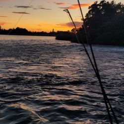
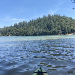
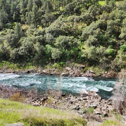
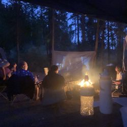
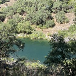
As of the 2017 season, water levels are finally back to normal! The water is clean, warm, and there's finally actual beach surrounding the lake. The coves and adjoining creek are now back to being accessible via kayak or small boat. This truly is a perfect spot for kayaking or canoeing (thanks largely in part to the 10mph wake limit). Unlike nearby large lakes like Rollins or Folsom, there's no fear of getting run over by a drunk boater or a daredevil jet skier. Just calm waters for swimming, paddling, and relaxing with the occasional fishing boat trolling by. A predominately paved trail surrounds the lake for an easy hike of about 4.5 miles that also crosses over the dam for a spectacular view of the reservoir. There are also several benches and nature facts posted along the way. Boat Launch is on the opposite side of the lake from the Manazanita Day Use area. The two campgrounds, Giant Gap and Shirttail Creek are on either side of Day Use. Apparently the secret is out that this is the place to be when the Sacramento Valley hits triple digit temperatures - it's about 90 minutes up Hwy 80 from Sacramento. I've been coming here for years and this is the first time I've seen so many cars overflowing the day use lot. Luckily, this lake is so large that even with every campsite taken in both campgrounds and a packed Day Use parking lot, it still didn't feel that crowded. It's even less crowded when you're kayaking in the middle of the lake ;)


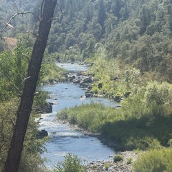
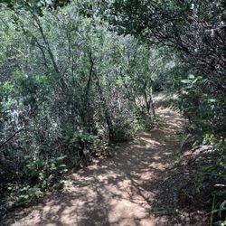
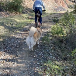
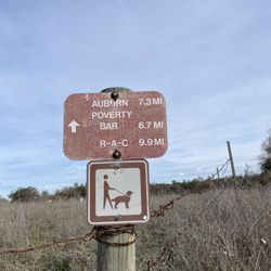
We wanted to go hiking and found the Joshua M. Hardt Memorial Trail, which circles around the reservoir. The loop was a bit over 4 miles. I'm glad it was mostly shaded and flat. The water was nice and clear. There were several benches along the way. Best of all, it wasn't crowded at all when we went. Bring cash- $5.00 per vehicle. read more


1 year ago
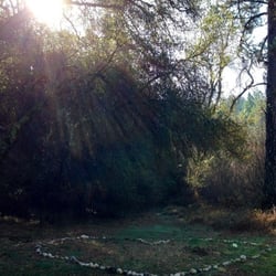
Beautiful reservoir and meandering trails. This is a great place to visit. We visited the Manzanita Day Use Area and walked a short distance on the paved trails. We also stopped at the dam to soak in the view. My only regret is that we didn't have more time to spend there. read more


3 years ago
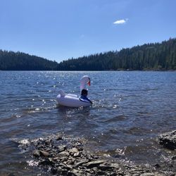
So beautiful!! Loved our time here. Can't wait to come back and hopefully camp. Only bummer was it was pretty noisy at the beaches so I suggest hiking a bit to find some peace and seclusion. There were lots of families which we loved to see. There were also some groups of people just drinking and being rowdy which is a bummer. Hope to see more families out here! read more

9 years ago
As of the 2017 season, water levels are finally back to normal! The water is clean, warm, and there's finally actual beach surrounding the lake. The coves and adjoining creek are now back to being accessible via kayak or small boat. This truly is a perfect spot for kayaking or canoeing (thanks largely in part to the 10mph wake limit). Unlike nearby large lakes like Rollins or Folsom, there's no fear of getting run over by a drunk boater or a daredevil jet skier. Just calm waters for swimming, paddling, and relaxing with the occasional fishing boat trolling by. A predominately paved trail surrounds the lake for an easy hike of about 4.5 miles that also crosses over the dam for a spectacular view of the reservoir. There are also several benches and nature facts posted along the way. Boat Launch is on the opposite side of the lake from the Manazanita Day Use area. The two campgrounds, Giant Gap and Shirttail Creek are on either side of Day Use. Apparently the secret is out that this is the place to be when the Sacramento Valley hits triple digit temperatures - it's about 90 minutes up Hwy 80 from Sacramento. I've been coming here for years and this is the first time I've seen so many cars overflowing the day use lot. Luckily, this lake is so large that even with every campsite taken in both campgrounds and a packed Day Use parking lot, it still didn't feel that crowded. It's even less crowded when you're kayaking in the middle of the lake ;) read more


6 years ago
Great for paddle boarding a little bit busy. But it's not bad. parking space is easy if you go early 9am you will find a great spot for parking no hassle to walk with paddle board lol. read more

7 years ago
Great place to get away from it all. Definitely one of my favorites and just a short drive from Sacramento. The camping is good, too, but bring your own drinking water as the water provided is very high in iron. read more


9 years ago
Best camping site 22 love this place but was told by the host they are going to raise the damn to catch more water and our favorite ones be under water in the next year or two I hope not it would be a shame read more


13 years ago
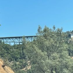
Over a decade ago I was lucky enough to stumble upon Sugar Pine Reservoir while driving through the hills and the beauty of the area continues to draw me back. Sugar Pine Reservoir is managed by the Tahoe National Forest under an agreement with the Bureau of Reclamation. Sugar Pine Reservoir contains two campgrounds (Shirttail Creek and Giant Gap), a boat ramp (10 mph speed limit which is great for those of us that enjoy flat water kayaking! -just watch out for the water snakes!), 4 mile hiking trail around the lake, picnic area and a beach. The DFG stocks rainbows here annually and there are also small and large mouth bass and some German browns. There are fees for the day use areas. read more

8 years ago
8 years ago
13 years ago
12 years ago
10 years ago
10 years ago
8 years ago
12 years ago
12 years ago
More info about Sugar Pine Reservoir
Ask the Community - Sugar Pine Reservoir
Are there any places to rent kayaks or paddle boards nearby?
Review Highlights - Sugar Pine Reservoir
You might also consider


Why does Yelp recommend reviews?
2 reviews that are not currently recommended
The reviews below are not factored into the business's overall star rating.
3 years ago
8 years ago
Sugar Pine Reservoir - lakes - Updated July 2026
Best of Foresthill
People found Sugar Pine Reservoir by searching for…
Fishing Spots in Foresthill, California
Fishing in Foresthill, California
Beaches in Foresthill, California
Swimming Holes in Foresthill, California
Campgrounds in Foresthill, California
Hiking Trails in Foresthill, California
Swimming Lakes in Foresthill, California
Watch Sunset in Foresthill, California
Trout Fishing in Foresthill, California
Parks in Foresthill, California
Picnic Areas in Foresthill, California
Secret Spots in Foresthill, California
Fishing Ponds in Foresthill, California
Scenic View in Foresthill, California
Lake Camping in Foresthill, California
Things to Do in Foresthill, California
View Points in Foresthill, California
Walking Trails in Foresthill, California
Swimming in Foresthill, California
Sunset View in Foresthill, California
Lakes & Ponds in Foresthill, California
Gold Panning in Foresthill, California
Trending Searches in Foresthill, CA
4th Of July Fireworks near Sugar Pine Reservoir
Black Owned Nail Salons near Sugar Pine Reservoir
Boat Launch near Sugar Pine Reservoir
Boat Rental near Sugar Pine Reservoir
Cliff Jumping near Sugar Pine Reservoir
Day Trips near Sugar Pine Reservoir
Fireworks near Sugar Pine Reservoir
Fishing Spots near Sugar Pine Reservoir
Flower Fields near Sugar Pine Reservoir
Jet Ski Rental near Sugar Pine Reservoir
Kayak Rental near Sugar Pine Reservoir
Lakes near Sugar Pine Reservoir
Outdoor Basketball Courts near Sugar Pine Reservoir
Picnic Areas near Sugar Pine Reservoir
Places To Swim near Sugar Pine Reservoir
Places To Walk Around near Sugar Pine Reservoir
Public Pools near Sugar Pine Reservoir
River Swimming near Sugar Pine Reservoir
Running Trails near Sugar Pine Reservoir
Soccer Store near Sugar Pine Reservoir
Splash Pad near Sugar Pine Reservoir
Strawberry Picking near Sugar Pine Reservoir
Swimming Holes near Sugar Pine Reservoir
Swimming Lakes near Sugar Pine Reservoir
Volleyball Courts near Sugar Pine Reservoir
Watch Sunset near Sugar Pine Reservoir
Water Parks near Sugar Pine Reservoir
Browse Articles
Browse Nearby
Browse Brands
Related Searches in Foresthill, CA
Affordable Kayak Rental Services in Foresthill, California
Best Fishing Locations and Guides in Foresthill, California
Best Nature Trails for Hiking in Foresthill, California
Best Waterfalls and Swimming Holes in Foresthill, California
Discover Dog Friendly Beaches Near Foresthill, California
Discover Lakes & Ponds to Explore in Foresthill, California
Discover Popular Photo Spots in Foresthill, California
Discover the Best Beaches in Foresthill, California
Discover the Best Fishing Lake in Foresthill, California
Dog-Friendly Hikes With Dogs in Foresthill, California
Enjoy Kayaking Adventures in Foresthill, California
Enjoy a Beautiful Waterfall Hike in Foresthill, California
Enjoy the Best Walking Trails in Foresthill, California
Explore Beautiful Parks and Green Spaces in Foresthill, California
Explore Easy Hikes Perfect for All in Foresthill, California
Explore Nature Spots Around Foresthill, California
Explore Popular Campgrounds Near Foresthill, California
Explore Popular Picnic Areas Around Foresthill, California
Explore Popular RV Parks Around Foresthill, California
Explore Popular View Points Around Foresthill, California
Explore Top Dog Parks in Foresthill, California Near You
Explore Top Marinas Near Foresthill, California
Explore Top Water Parks in Foresthill, California Today
Explore the Best Boating Spots in Foresthill, California
Explore the Best Swimming Holes Around Foresthill, California
Explore the Best Trail Options in Foresthill, California
Explore the Scenic River in Foresthill, California
Find Beautiful Views in Foresthill, California
Find Top Skate Parks in Foresthill, California for All Skill Levels
Find Top-Rated Waterfalls in Foresthill, California Now
Find the Best Parks BBQ Grills in Foresthill, California
Find the Best Playgrounds to Visit in Foresthill, California
Find the Best Swimming Pools in Foresthill, California Today
Have Fun at a Splash Pad in Foresthill, California
Hiking Trails With Waterfalls in Foresthill, California
Play at a Splash Pad Park in Foresthill, California
Popular Fishing Spots to Explore in Foresthill, California
Popular Outdoor Activities to Try in Foresthill, California
Popular Places to Take Pictures in Foresthill, California
Relax at Natural Hot Springs Near Foresthill, California
Safe River Swimming Areas in Foresthill, California
Safe and Fun Parks for Kids in Foresthill, California
Top Fishing Ponds to Visit in Foresthill, California
Top Hiking Trails to Explore in Foresthill, California
Top Playgrounds for Kids to Enjoy in Foresthill, California
Top Running Trails to Explore in Foresthill, California
Top Swimming Lakes to Enjoy in Foresthill, California
Top Swimming Spots and Pools in Foresthill, California
Top-Rated Hikes in Foresthill, California to Explore
Walk the Best Paved Walking Trails in Foresthill, California
People who viewed Sugar Pine Reservoir also viewed
Lake Valley Reservoir
10 reviews
Lake Clementine
150 reviews
Rollins Lake
18 reviews
Fuller Lake
7 reviews
French Meadows Campground
25 reviews
American River Confluence
12 reviews
Hidden Falls Regional Park
280 reviews
Englebright Lake
3 reviews
Clementine Lake Loop or Culvert Loop
23 reviews
Halsey Forebay Picnic Area
5 reviews