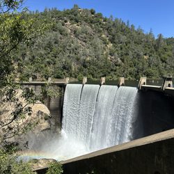
1. Halsey Forebay Picnic Area

0

Auburn, CA

Cancel

Open app

Search

Halsey Forebay Picnic Area

4.8 (5 reviews)

Halsey Forebay Picnic Area Photos

You might also consider

More like Halsey Forebay Picnic Area

Recommended Reviews - Halsey Forebay Picnic Area

Your trust is our priority, so businesses can't pay to alter or remove their reviews. Learn more about reviews.
Yelp app icon
Browse more easily on the app
Review Feed Illustration

2 years ago
Helpful 25
Thanks 6
Love this 21
Oh no 0

8 months ago

Helpful 22
Thanks 6
Love this 17
Oh no 0

6 years ago

Helpful 3
Thanks 0
Love this 1
Oh no 0

4 years ago

Helpful 4
Thanks 1
Love this 1
Oh no 0
Photo of Mike B.
376
3
0

9 years ago

Helpful 2
Thanks 1
Love this 1
Oh no 1

You might also consider

Verify this business for free

People searched for Parks 785 times last month within 15 miles of this business.

Verify this business

Hidden Falls Regional Park

Hidden Falls Regional Park

4.3(280 reviews)
6.9 mi

Another nice, easy hike to add to our list around the Roseville area! Biggest tip is to be sure and…read morego online to reserve ahead of time and pay a small fee, if necessary. Reservations are required on weekends, some Fridays, and selected dates. Otherwise, Mon thru Thu are free with no reservations required. Parking available inside is limited so come early to avoid the hassle. I believe they open at 6:30 AM and closing is dependent on sundown. We hiked with our 2 little girls and dogs. Even with the little ones, we were able to make it to the Canyon View Overlook and back. In case your dog needs a bathroom break, bag it up and I recall there was at least one trash can along the path towards the Overlooks. Help keep this hiking gem clean! Scenery was gorgeous, hike was pretty easy without difficulty, and be sure to visit both Overlooks for some beautiful sights. We took the North Legacy Way, in case you're curious. Great for hiking enthusiasts, families, quality time with nature, and perfect for those that want to avoid lots of foot traffic!

Paid for the ticket reservation online. $8 for all day parking pass. They have $4 options but those…read moreare for early morning or later in the afternoon. I much prefer a reservation system like this because it saves on the stress and time of fighting for parking and an overcrowded park. People who rated this low are just mad because they didn't do research or come prepared. Theres plenty of trail options here but we did the main hidden falls loop trail that was on AllTrails. (Poppy Trail, N Legacy Way, then Hidden Falls Access Trail, total loop about 3.2 miles) It was a beautiful hike with tons of mushrooms everywhere right now, and hidden falls is flowing! Theres two observation decks. I kind of don't like how the deck at hidden falls is right above the falls so it blocks the falls, you have to look down over the rail/ledge, so there's no way you can get a good photo with the falls behind you

Photos
Hidden Falls Regional Park
Hidden Falls Regional Park - California Sister

California Sister

Hidden Falls Regional Park

See all

American River Canyon Overlook Park - Mushroom

American River Canyon Overlook Park

5.0(11 reviews)
6.2 mi

If you can handle straight down and straight up hiking, trail running, or horseback riding with…read morecliff drop-offs, this Bud's for you! Head down the paved road to the river. Someone else said it's 3 miles round trip but my Strava says 3.2 miles up from the river with 800' gain. :shrug Check out Alltrails app for more input and routes. If you stick to the pavement route, the path is very wide, two cars width and more at times. So no fears of steep drop-offs. Beyond the river, it's single track. On the dirt routes going down to the river, it's very technical and steep. Though I've never been on it, I know about K2/Cardiac Hill. LOL! If you want to explore the Western States trail that's used by Tevis Cup and Western States Endurance Race (both 100 mile endurance races one on horse one on foot), then head down the dirt trail off the horse side. If you travel a little more than 3 miles down this path you'll encounter a waterfall if there's still flowing water. Cross in the water or on the bridge (horses ok either way). But again, this trail isn't for the faint of heart when it comes to horses and their riders. Be mindful it may be too much for you or your horse. Horse side has a large watering hole that had water in it in early April 2023 (while some locations fear the horse sicknesses and have shut off water). There's also tying rails. And plenty of room to maneuver a rig. Paved side has a building with restrooms. The restroom is accessed by the paved lot but is on the side nearest the dirt lot/horse trailer parking. I don't recall it having soap or towels or hand dryers in April 2023. C'mon 'rona, give us soap even if it's the sandpaper powder! Be aware that some days there are major events and you may not be able to park there. I suppose you can call City of Auburn or just be prepared to go somewhere different such as railroad park. Major events include: Tevis Cup, Western States Endurance Race, and American River Endurance Race.

Beautiful large park. Costs $7 to enter/park, and there's a strict close time to leave at sundown…read more Highly recommend for biking, but not so much for casual walking with kids. This place is huge and has a decent amount of hills and flat areas.

Photos
American River Canyon Overlook Park - Equestrian side (dirt lot) next to the canal at sunset. April 2, 2023

Equestrian side (dirt lot) next to the canal at sunset. April 2, 2023

American River Canyon Overlook Park
American River Canyon Overlook Park - On the hiking trail

See all

On the hiking trail

Auburn State Recreation Area - Tamaroo Bar Trail 12/2023

Auburn State Recreation Area

4.5(76 reviews)
4.4 mi

Gorgeous landscape! I recently completed the Quarry trail and it was a beautiful walk. The entire…read morepark is great for enjoying nature and exploring the outdoors for various levels of activity. For the Quarry trail, I recommend parking along the main road if you find a parking spot. The parking lot at the trailhead is tiny, and always full. This trail has plenty of portable bathroom stalls and is paved.

I luv hiking the multitude of trails in the Auburn State Recreation Area (ASRA). The area covers 40…read moremiles of the north and middle forks of the American River. Lots of trails for hiking, mountain biking, and horse riding. It is a beautiful area with hills, Foresthill bridge, lake, and the river. I am not an avid hiker. More of a leisurely stroller. There are various trails with different elevation gains, distance, and difficulty. Most of the time that I came out to this area is to just hike near the confluence and sit along the river bank and take in the sights and sounds. If you go in the summer, just be aware that the temperatures can hit triple digits during the day and there can be very little shade on the trails. There is no potable water stations on the trails. Parking is limited to what is available along the side of the road near the trailheads. The spots fill up quickly on the weekend. The fee is $10. But from April 1- October 1 on the weekends 9am-5pm, there is a transit bus rides from designated areas in Auburn to the Ranger station at the confluence crossing (near Highway 49 and Old Foresthill Road). The rides need to be reserved though, details on the ride program (cost, reservations, route) are on the state parks website. The ASRA is managed by the State of California Parks Department.

Photos
Auburn State Recreation Area - Tamaroo Bar Trail

Tamaroo Bar Trail

Auburn State Recreation Area
Auburn State Recreation Area - Olmstead Loop Trail

See all

Olmstead Loop Trail

Clementine Lake Loop or Culvert Loop - Goth butterfly

Clementine Lake Loop or Culvert Loop

4.8(23 reviews)
4.2 mi

I am a beginning hiker and I went here on a whim because of parking being an issue. I do have to…read moresay that this hike is stunning and not bad for a beginner like me! If you are hiking in this Auburn area, I do highly recommend that you arrive EARLY for the parking situation. This place gets pretty busy. I believe this is because this area is trending on TikTok for beautiful hikes. We had to circle over and over again and only got parking because a car full of people next to us had the decency to move over a bit to fit two Jeeps with 5 humans and 1 big dog! Back to the hike...this was so nice by the water. There were many places I enjoyed resting to just take in all the nature. For some reason I found hiking to the dam more difficult that walking back to the parking spot. I think it was because it was new for me and I wasn't used to it. This hike was not too bad especially when it comes to inclines and steepness levels. Definitely check out Clementine Lake Loop because it is beautiful and doable.

Have now done this hike/loop a few times now and it's definitely worth the drive and parking…read morefiasco. The trail is about 4 miles long and takes just a couple hours to do at a slow/medium pace. The trail is pretty wide, there were people with their dogs, a few little kids, and lots of groups enjoying the beautiful day. The majority of the trail is shady and covered by beautiful trees, some spots are under the direct sun so bring a hat or sunnies. You'll see tons of butterflies, wild flowers, birds, and of course will see the spillway. Parking is $10 cash paid to the park. This most recent time that I came it was very difficult to find parking, so if you plan to come on a weekend plan ahead and come early. I would also recommend bringing bus spray and being cautious of the poison ivy along the sides of the trail. Overall it's a beautiful hike and I'd recommend it!

Photos
Clementine Lake Loop or Culvert Loop
Clementine Lake Loop or Culvert Loop - Waterfall at the dam

Waterfall at the dam

Clementine Lake Loop or Culvert Loop - Waterfall

See all

Waterfall

Halsey Forebay Picnic Area - parks - Updated October 2026

Loading...
Loading...
Loading...