We two (and our dog) stayed four nights at the Tamarack Cabin in late March, so my comments are related to that experience.
For people who enjoy isolation and snowshoeing, late March is a good time to stay. Though we won't make the 6-hour drive from the Seattle area again, staying this one time was worthwhile for us.
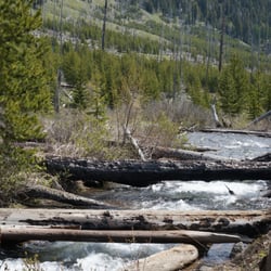
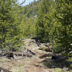
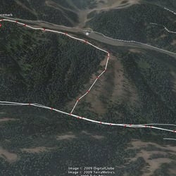
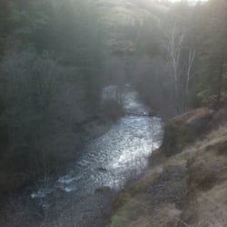
PARK STAY LATE MARCH: 4.0. Very isolated and peaceful. We saw no other visitors during our 5 days, and rarely saw a ranger. The two park lodges and the sledding hills were closed, and it was too late in the season for cross-country skiing. No internet. No (T-mobile) cellphone coverage other than in one small area on the trails, and a very weak signal on Puffer Butte. There was still snow on the ground, and it snowed an inch or so the night of our arrival. The camp ranger said they usually get a late Feb snow, and that this year (2021) it had been unusually heavy. We snowshoed almost all the trails, going to Puffer Butte twice. We had never snowshoed before but found it easy.
In winter the main entrance is closed. The winter entrance is located just a few yards north of it.
Though the park does have snowshoes for rent, we had already rented two pairs (which came with poles and very handy backpacks) from Arrive Outdoors (which we learned of through our cabin confirmation letter from the state of WA).
There was no outdoor light in the park at night, so on clear nights the night sky was brilliant with stars.
The view from Puffer Butte was quite nice. There is a nice lodge open to all during the day and available to sleep in at night. It contained a wood-burning stove, with plenty of firewood outside. No running water, but there is a large Honeypot toilet outside.
TAMARACK CABIN: 3.0.
Quite different from the "standard" kit cabins we have stayed at in other WA and OR parks; those other cabins are preferable. The cabin fills most of a small building; the rear of the building has a separate padlocked door and appears to be a storage room.
NOTE: if checking-in after the ranger station closure time, be sure to bring a flashlight. There is no outdoor light at the cabin, and one needs to read the check-in procedure posted next to the cabin's door.
PROS:
- Isolated: there is only one cabin. A lodge where multiple people can stay is located about 30 meters behind the cabin but was closed during our stay.
- bathroom with shower.
- Heater.
- comfortable queen bed (we didn't use the bunk bed).
CONS:
- Oddly-shaped interior with no "dining" table. We used the provided long narrow table and the two metal folding chairs. There are only 2 chairs available, so if 4 people are staying then 2 folks would need to sit on the end of the queen bed. Or eat outside. (The picnic table was covered in snow when we stayed, so that was not an option.)
- The main heater is located over the queen bed. It is rather noisy when running, but bearable. Due to its high position, there is quite a temperature differential between the upper part of the cabin and floor-level. A space heater is also provided in the bathroom, and it can be moved into the main room. (Our dog was pleased with the space heater at her lower level.)
We brought a propane stovetop that we used on the porch, which was very handy to have. (There is a firepit in front of the cabin that had been cleared of snow, but we didn't use it.)
The cabin has a microwave oven, but no "kitchen" sink. There is only the small sink in the bathroom.
NOTE: the shower sometimes emitted only a tiny dribble of hot water. I was able to resolve this by (1) turning off the shower, (2) reaching out to the bathroom sink and turning on, then off, the hot water, (3) turning the shower water back on.
NOTE: be sure to bring along enough food for your stay. The nearest grocery is over 30 minutes away over mostly unlit roads.
Though it wasn't open during our stay, one of the park's two sledding slopes is located about 30 meters behind the cabin. read more