Enchanted Forest Trailhead Photos


You might also consider
More like Enchanted Forest Trailhead
Recommended Reviews - Enchanted Forest Trailhead
Start your review...

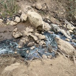
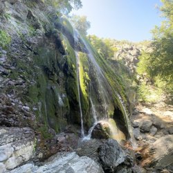
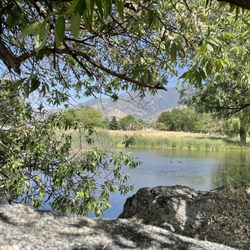
The Enchanted Forest Trail is one of the closest trailheads to the center of Pine Mountain Club, and one that was marked on both Google Maps and on the map of hiking trails provided by the Pine Mountain Inn (5*). With such an inviting name, my friend and I wanted to be sure to check it out. Arriving in Pine Mountain Club on a Friday afternoon in April, we decided to save a longer trail for Saturday and visit the Enchanted Forest Trail with about 1.5 hours remaining before sundown. The trailhead is very simple to find. From there, the trail was not difficult to follow until it brought us to a rocky dry watercourse on the mountain. We had read that the track might get lost, but most of the reviews on AllTrails saying that were from winter. We had followed the path pretty easily until the watercourse, but at that point we lost it. We considered scrambling up the rocky gorge but that seemed wrong. At that moment, we heard voices echoing in the canyon, and that directed my attention over across the watercourse into the underbrush. We realized we could cross the gulch and find the trail on the other side. Locating the path, we soon passed the people coming down from the trail's end. We asked how it was, and they said "it gets steep and rocky." It had already been like that, so we wondered how much steeper and more rocky it might be. After going on for another 5-7 minutes, we arrived at an area on the path that felt like it was vibrating with energy. Neither of us is particularly spiritual but this place, where a large redwood had fallen with a tremendous, splintered split across its trunk and where someone had placed a stone cairn, felt inexplicably mysterious. (See my pic. The place where the trunk splits is taller than the height of a person.) The sun had just dipped behind the ridgeline, and we decided this would be where we would stop. It's an out-and-back trail, so why not make this our back point? On the way down the trail, I started to get tinnitus in my right ear. This isn't something that has happened to me in recent memory. Maybe because the area is so quiet, I could hear a ringing in my ears. But then, out of nowhere, a tree started dropping its leaves on the path to our left. No wind blew, nothing discernible changed. Leaves just started dropping. We thanked the forest for hosting us, and made our way down the path--without urgency, but expeditiously. Whatever's enchanting this forest was probably having a good time. We did too. Just be ready for a hint of the chills as you hike along. read more


3 years ago
I like this trail, it lives up to its name and is very much like walking through a movie forest. Trees split in half, old rock slides, echo-y mountains give this trail such a good and on edge vibe. Unfortunately we had to head back early because the ground was too frozen to walk on without some sort of special ice gear. read more
2 years ago
More info about Enchanted Forest Trailhead
1205 Bernina Dr
Pine Mountain Club, CA 93222
Directions
Hours
Outdoor Amenities
You might also consider


Why does Yelp recommend reviews?
1 review that is not currently recommended
The reviews below are not factored into the business's overall star rating.
4 years ago
Enchanted Forest Trailhead - hiking - Updated August 2026
Best of Pine Mountain Club
People found Enchanted Forest Trailhead by searching for…
Things to Do in Pine Mountain Club, CA
Hiking Trails in Pine Mountain Club, CA
Parks in Pine Mountain Club, CA
Playgrounds in Pine Mountain Club, CA
Redwood Trees in Pine Mountain Club, CA
Running Trails in Pine Mountain Club, CA
Waterfalls and Swimming Holes in Pine Mountain Club, CA
Walking Trails in Pine Mountain Club, CA
Views in Pine Mountain Club, CA
Off Road Trails in Pine Mountain Club, CA
Beautiful Views in Pine Mountain Club, CA
Waterfalls in Pine Mountain Club, CA
Trail in Pine Mountain Club, CA
Secluded Spots in Pine Mountain Club, CA
Places to Go in Pine Mountain Club, CA
Places to Run in Pine Mountain Club, CA
Sunset View in Pine Mountain Club, CA
Places to Take Pictures in Pine Mountain Club, CA
Dog Friendly Beaches in Pine Mountain Club, CA
Nature in Pine Mountain Club, CA
Scenic Overlook in Pine Mountain Club, CA
Trending Searches in Pine Mountain Club, CA
Black Owned Nail Salons near Enchanted Forest Trailhead
Fishing Spots near Enchanted Forest Trailhead
Lakes near Enchanted Forest Trailhead
Parks near Enchanted Forest Trailhead
Picnic Areas near Enchanted Forest Trailhead
River Swimming near Enchanted Forest Trailhead
Scenic Overlook near Enchanted Forest Trailhead
Splash Pad near Enchanted Forest Trailhead
Swimming Holes near Enchanted Forest Trailhead
Watch Sunset near Enchanted Forest Trailhead
Waterfalls And Swimming Holes near Enchanted Forest Trailhead
Browse Articles
Browse Nearby
BEST of Pine Mountain Club, California Restaurants near Enchanted Forest Trailhead
BEST of Pine Mountain Club, California Parks near Enchanted Forest Trailhead
BEST of Pine Mountain Club, California Coffee near Enchanted Forest Trailhead
BEST of Pine Mountain Club, California Things to Do near Enchanted Forest Trailhead
BEST of Pine Mountain Club, California Photo Spots near Enchanted Forest Trailhead
BEST of Pine Mountain Club, California Breakfast near Enchanted Forest Trailhead
BEST of Pine Mountain Club, California Sledding near Enchanted Forest Trailhead
BEST of Pine Mountain Club, California Campgrounds near Enchanted Forest Trailhead
BEST of Pine Mountain Club, California Ski Resorts near Enchanted Forest Trailhead
Browse Brands
Related Searches in Pine Mountain Club, CA
Best Dog Hiking Trails Around Pine Mountain Club, California
Best Fishing Locations and Guides in Pine Mountain Club, California
Best Fun Things to Do in Pine Mountain Club, California
Best Places for Horseback Riding in Pine Mountain Club, California
Best Waterfalls and Swimming Holes in Pine Mountain Club, California
Check Out Off Road Trails in Pine Mountain Club, California
Discover Dog Friendly Trails to Explore in Pine Mountain Club, California
Discover Popular Photo Spots in Pine Mountain Club, California
Discover Scenic Mountain Bike Trails Near Pine Mountain Club, California
Discover a Hiking Trail in Pine Mountain Club, California
Discover the Best Beaches in Pine Mountain Club, California
Discover the Best Night Hike Trails in Pine Mountain Club, California
Dog-Friendly Hikes With Dogs in Pine Mountain Club, California
Enjoy Camping Adventures Around Pine Mountain Club, California
Enjoy Off Leash Dog Hikes in Pine Mountain Club, California
Enjoy Tent Camping Spots Around Pine Mountain Club, California
Explore Beautiful Parks and Green Spaces in Pine Mountain Club, California
Explore Bike Rentals Throughout Pine Mountain Club, California
Explore Easy Hikes Perfect for All in Pine Mountain Club, California
Explore Free Things to Do Around Pine Mountain Club, California
Explore Fun Activities to Do in Pine Mountain Club, California
Explore Popular Campgrounds Near Pine Mountain Club, California
Explore Popular Scenic Overlook Points in Pine Mountain Club, California
Explore Popular Scenic Views Near Pine Mountain Club, California
Explore Scenic Lakes to Visit in Pine Mountain Club, California
Explore Secret Spots Worth Visiting in Pine Mountain Club, California
Explore Summer Camps for All Ages in Pine Mountain Club, California
Explore Top Dog Parks in Pine Mountain Club, California Near You
Explore the Best Swimming Holes Around Pine Mountain Club, California
Family Friendly Hiking With Kids in Pine Mountain Club, California
Find Beautiful Views in Pine Mountain Club, California
Find Top Skate Parks in Pine Mountain Club, California for All Skill Levels
Find the Best Playgrounds to Visit in Pine Mountain Club, California
Find the Best Swimming Pools in Pine Mountain Club, California Today
Hiking Trails With Waterfalls in Pine Mountain Club, California
Off Leash Dog Hiking Trails in Pine Mountain Club, California
Plan a Scenic Drive Route Near Pine Mountain Club, California
Popular Places to Take Pictures in Pine Mountain Club, California
Popular Things to Do in Pine Mountain Club, California
Relax at Natural Hot Springs Near Pine Mountain Club, California
Safe River Swimming Areas in Pine Mountain Club, California
Top Hiking Trails to Explore in Pine Mountain Club, California
Top Running Trails to Explore in Pine Mountain Club, California
Top Things to Do With Kids in Pine Mountain Club, California
Top-Rated Camping Sites in Pine Mountain Club, California
Walk Dog Friendly Hiking Trails in Pine Mountain Club, California
People who viewed Enchanted Forest Trailhead also viewed
Mount Pinos
43 reviews
The Wildlands Conservancy's Wind Wolves Preserve
81 reviews
Reyes Creek Campground
41 reviews
Pyramid Lake Recreation Area/Los Alamos Campground
240 reviews
McGill Campground
26 reviews
Taft Rails to Trails
2 reviews
Enjoy The Mountain
62 reviews
BSA Camp 3 Falls
3 reviews
Campo Alto Campground
1 review
Camp St. Nicholas
6 reviews