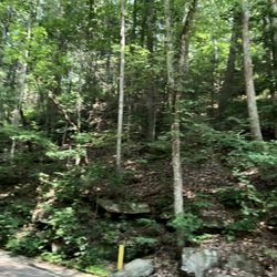
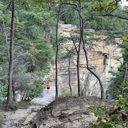
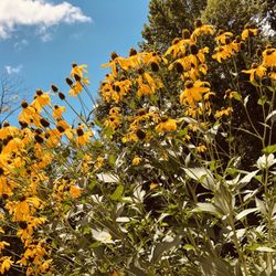
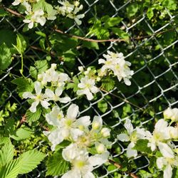
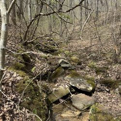
Edwards Point Photos


You might also consider
More like Edwards Point
Recommended Reviews - Edwards Point
Start your review...

This was such a fun hike! The views were AMAZING and the only other people there were hikers like us (and a few strong fur babies!). It took a good chunk of our day and was several miles down and back. Springtime is beautiful to see flowers blooming, sun shining, and birds chirping. We were sore the next day but man my calves were feeling STRONG. Some spots were much steeper than others and I honestly wouldn't recommend bringing young kiddos on this trail. Great spots for photos and plenty of space to sit and enjoy the overlook with other hikers. read more


More info about Edwards Point
Signal Mountain, TN 37377
Directions
Hours
Outdoor Amenities


Edwards Point - hiking - Updated May 2026
Best of Signal Mountain
People found Edwards Point by searching for…
Scenic Overlook in Signal Mountain, Tennessee
Beautiful Views in Signal Mountain, Tennessee
Things to Do in Signal Mountain, Tennessee
Hiking Trails in Signal Mountain, Tennessee
Walking Trails in Signal Mountain, Tennessee
Waterfalls in Signal Mountain, Tennessee
Photo Spots in Signal Mountain, Tennessee
Lookout Points in Signal Mountain, Tennessee
View Points in Signal Mountain, Tennessee
Off Road Trails in Signal Mountain, Tennessee
Running Trails in Signal Mountain, Tennessee
Scenic View in Signal Mountain, Tennessee
Bike Paths in Signal Mountain, Tennessee
Trail in Signal Mountain, Tennessee
Views in Signal Mountain, Tennessee
Off Leash Dog Hikes in Signal Mountain, Tennessee
Easy Hikes in Signal Mountain, Tennessee
Places to Take Pictures in Signal Mountain, Tennessee
What to Do in Signal Mountain, Tennessee
Things to Do at Night in Signal Mountain, Tennessee
To Do in Signal Mountain, Tennessee
Watch Sunset in Signal Mountain, Tennessee
Trending Searches in Signal Mountain, TN
Botanical Gardens near Edwards Point
Bounce House Rentals near Edwards Point
Campgrounds near Edwards Point
Cliff Jumping near Edwards Point
Dog Friendly Trails near Edwards Point
Floral Designers near Edwards Point
Flower Fields near Edwards Point
Flower Shop near Edwards Point
Free Picnic Areas near Edwards Point
Garage Sales near Edwards Point
Garden Center near Edwards Point
Golf Lessons near Edwards Point
Mountain Bike Trails near Edwards Point
Nurseries & Gardening near Edwards Point
Outdoor Activities near Edwards Point
Outdoor Furniture Stores near Edwards Point
Party Equipment Rentals near Edwards Point
Photo Spots near Edwards Point
Places To Take Pictures For Prom near Edwards Point
Rock Quarry near Edwards Point
Running Trails near Edwards Point
Spray Tanning near Edwards Point
Browse Articles
Browse Nearby
BEST of Signal Mountain, Tennessee Restaurants near Edwards Point
BEST of Signal Mountain, Tennessee Coffee near Edwards Point
BEST of Signal Mountain, Tennessee Things to Do near Edwards Point
BEST of Signal Mountain, Tennessee Walking Trails near Edwards Point
BEST of Signal Mountain, Tennessee Parks near Edwards Point
BEST of Signal Mountain, Tennessee Breakfast near Edwards Point
BEST of Signal Mountain, Tennessee Caves near Edwards Point
BEST of Signal Mountain, Tennessee Hotels near Edwards Point
BEST of Signal Mountain, Tennessee Campgrounds near Edwards Point
Browse Brands
Related Searches in Signal Mountain, TN
Affordable Kayak Rental Services in Signal Mountain, Tennessee
Best Places for Horseback Riding in Signal Mountain, Tennessee
Discover Dog Friendly Trails to Explore in Signal Mountain, Tennessee
Discover Scenic Mountain Bike Trails Near Signal Mountain, Tennessee
Discover Scenic Waterfall Spots in Signal Mountain, Tennessee
Discover Top Nature Parks to Visit in Signal Mountain, Tennessee
Discover a Hiking Trail in Signal Mountain, Tennessee
Discover the Best Night Hike Trails in Signal Mountain, Tennessee
Discover the Best Running Track in Signal Mountain, Tennessee
Dog-Friendly Hikes With Dogs in Signal Mountain, Tennessee
Enjoy Exciting Mountain Biking Adventures in Signal Mountain, Tennessee
Enjoy Kayaking Adventures in Signal Mountain, Tennessee
Enjoy Water Activities and Fun in Signal Mountain, Tennessee
Enjoy the Best Tubing Experiences in Signal Mountain, Tennessee
Enjoy the Best Walking Trails in Signal Mountain, Tennessee
Exciting Cliff Jumping Spots in Signal Mountain, Tennessee
Experience Thrilling White Water Rafting in Signal Mountain, Tennessee
Explore Beautiful Parks and Green Spaces in Signal Mountain, Tennessee
Explore Bike Rentals Throughout Signal Mountain, Tennessee
Explore Popular Campgrounds Near Signal Mountain, Tennessee
Explore Popular RV Parks Around Signal Mountain, Tennessee
Explore Popular Scenic Overlook Points in Signal Mountain, Tennessee
Explore Top Dog Parks in Signal Mountain, Tennessee Near You
Explore Top Water Parks in Signal Mountain, Tennessee Today
Explore the Best Boating Spots in Signal Mountain, Tennessee
Explore the Best Swimming Holes Around Signal Mountain, Tennessee
Family Friendly Hiking With Kids in Signal Mountain, Tennessee
Find Beautiful Views in Signal Mountain, Tennessee
Find Popular Ziplining Spots Around Signal Mountain, Tennessee
Find Top Dog Swimming Spots in Signal Mountain, Tennessee
Find the Best Parks for Picnics in Signal Mountain, Tennessee
Find the Best Playgrounds to Visit in Signal Mountain, Tennessee
Hiking Trails With Waterfalls in Signal Mountain, Tennessee
Off Leash Dog Hiking Trails in Signal Mountain, Tennessee
Perfect Spots to Watch Sunset in Signal Mountain, Tennessee
Plan a Scenic Drive Route Near Signal Mountain, Tennessee
Popular Fishing Spots to Explore in Signal Mountain, Tennessee
Popular Kids Activities in Signal Mountain, Tennessee
Popular Outdoor Activities to Try in Signal Mountain, Tennessee
Popular Picnic Spots to Visit in Signal Mountain, Tennessee
Popular Things to Do in Signal Mountain, Tennessee
Popular Things to See in Signal Mountain, Tennessee
Relax at Natural Hot Springs Near Signal Mountain, Tennessee
Top Climbing Spots and Gyms in Signal Mountain, Tennessee
Top Playgrounds for Kids to Enjoy in Signal Mountain, Tennessee
Top Running Trails to Explore in Signal Mountain, Tennessee
Top Swimming Lakes to Enjoy in Signal Mountain, Tennessee
Top Things to Do With Kids in Signal Mountain, Tennessee
Visit Popular BBQ Park Locations in Signal Mountain, Tennessee
Walk Dog Friendly Hiking Trails in Signal Mountain, Tennessee
People who viewed Edwards Point also viewed
Glen Falls Trail
27 reviews
Booker T Washington State Park
8 reviews
The Greenway
1 review
Fletcher Park
6 reviews
Falling Water Falls Trail
4 reviews
Big Soddy Creek Gulf
7 reviews
Raccoon Mountain Recreation Area and Trails
25 reviews
Foster Falls Small Wild Area
11 reviews
Mountain Creek Park
2 reviews
Prentice Cooper State Forest
5 reviews