Signal Mountain Photos


You might also consider
More like Signal Mountain
Recommended Reviews - Signal Mountain
Start your review...

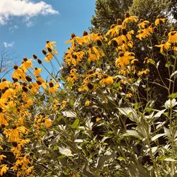
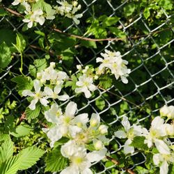
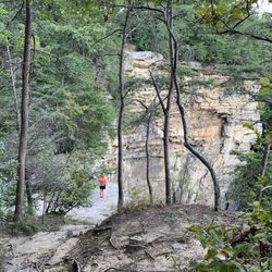
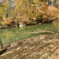
It's Spring and that time of year to go see the sights at Signal Mountain. What I mean are the breathtaking views from the top of the mountains. They call this 'The Brow', partly because of the shape it makes viewing it from the ground, and also because of the views you can see of the ground from up top the mountains. Along the way there are beautiful things blooming, turning gorgeous colors. Lots of green, lots of flowers with different shapes and colors. There are winding roads leading up so high that you have to swallow to catch your own hearing again from the sudden height increase. You'll see waterfalls along the roads of every kind. Tiny little trickles of water coming from behind the huge outcroppings of granite and also many gushing long waterfalls, too. Flowers galore. Blooming trees and lakes. Nature. All of it is pretty and all of it worthy of a trip out to take a drive or a nice long hike. read more


More info about Signal Mountain
Red Bank, TN 37405
Directions
Hours
Outdoor Amenities


Signal Mountain - hiking - Updated May 2026
Best of Red Bank
People found Signal Mountain by searching for…
Beautiful Views in Red Bank, Tennessee
Hiking Trails With Waterfalls in Red Bank, Tennessee
Things to Do in Red Bank, Tennessee
Waterfalls in Red Bank, Tennessee
Scenic Drive in Red Bank, Tennessee
Waterfalls and Swimming Holes in Red Bank, Tennessee
Flower Fields in Red Bank, Tennessee
Walking Trails in Red Bank, Tennessee
Scenic View in Red Bank, Tennessee
Places to Take Pictures in Red Bank, Tennessee
Night View in Red Bank, Tennessee
Natural Hot Springs in Red Bank, Tennessee
Picnic Spots in Red Bank, Tennessee
Easy Hikes in Red Bank, Tennessee
View Points in Red Bank, Tennessee
Running Trails in Red Bank, Tennessee
Photo Spots in Red Bank, Tennessee
Bike Paths in Red Bank, Tennessee
Scenic Overlook in Red Bank, Tennessee
Picnic Areas in Red Bank, Tennessee
Lakes & Ponds in Red Bank, Tennessee
Playgrounds in Red Bank, Tennessee
Trending Searches in Red Bank, TN
Baseball Fields near Signal Mountain
Botanical Gardens near Signal Mountain
Bounce House Rentals near Signal Mountain
Campgrounds near Signal Mountain
Cliff Jumping near Signal Mountain
Dog Friendly Things To Do near Signal Mountain
Fishing Spots near Signal Mountain
Flower Fields near Signal Mountain
Flower Shop near Signal Mountain
Garage Sales near Signal Mountain
Garden Center near Signal Mountain
Kids Friendly Beaches near Signal Mountain
Mountain Bike Trails near Signal Mountain
Nurseries & Gardening near Signal Mountain
Off Leash Dog Parks near Signal Mountain
Outdoor Activities near Signal Mountain
Outdoor Furniture Stores near Signal Mountain
Party Equipment Rentals near Signal Mountain
Photo Spots near Signal Mountain
Pick Your Own Farms near Signal Mountain
Picnic Areas near Signal Mountain
Places To Take Pictures near Signal Mountain
Rock Quarry near Signal Mountain
Running Trails near Signal Mountain
Rv Rental near Signal Mountain
Splash Pad near Signal Mountain
Strawberry Picking near Signal Mountain
Swimming Holes near Signal Mountain
Table And Chair Rentals near Signal Mountain
Tennis Courts near Signal Mountain
Walking Trails near Signal Mountain
Browse Nearby
BEST of Red Bank, Tennessee Restaurants near Signal Mountain
BEST of Red Bank, Tennessee Things to Do near Signal Mountain
BEST of Red Bank, Tennessee Coffee near Signal Mountain
BEST of Red Bank, Tennessee Breakfast near Signal Mountain
BEST of Red Bank, Tennessee Playgrounds near Signal Mountain
Browse Brands
Related Searches in Red Bank, TN
Affordable Kayak Rental Services in Red Bank, Tennessee
Best Fishing Locations and Guides in Red Bank, Tennessee
Best Fun Things to Do in Red Bank, Tennessee
Best Places for Horseback Riding in Red Bank, Tennessee
Best Water Parks for Kids in Red Bank, Tennessee
Check Out Great Playgrounds in Red Bank, Tennessee
Check Out Off Road Trails in Red Bank, Tennessee
Discover Baseball Fields Around Red Bank, Tennessee
Discover Dog Friendly Trails to Explore in Red Bank, Tennessee
Discover Free Parking Options in Red Bank, Tennessee
Discover Fun Activities to Do in Red Bank, Tennessee
Discover Popular Photo Spots in Red Bank, Tennessee
Discover Top Boat Tours in Red Bank, Tennessee for All Ages
Discover Top Nature Parks to Visit in Red Bank, Tennessee
Discover a Hiking Trail in Red Bank, Tennessee
Discover the Best Beaches in Red Bank, Tennessee
Discover the Best Night Hike Trails in Red Bank, Tennessee
Enjoy Exciting Mountain Biking Adventures in Red Bank, Tennessee
Enjoy River Tubing Adventures in Red Bank, Tennessee
Enjoy Tent Camping Spots Around Red Bank, Tennessee
Enjoy the Best Family Activities in Red Bank, Tennessee
Enjoy the Best Picnic Spots and Ideas in Red Bank, Tennessee
Enjoy the Best Tubing Experiences in Red Bank, Tennessee
Enjoy the Best Walking Trails in Red Bank, Tennessee
Experience Thrilling White Water Rafting in Red Bank, Tennessee
Explore Beautiful Botanical Gardens in Red Bank, Tennessee
Explore Beautiful Parks and Green Spaces in Red Bank, Tennessee
Explore Bike Rentals Throughout Red Bank, Tennessee
Explore Easy Hikes Perfect for All in Red Bank, Tennessee
Explore Free Kids Activities Near Red Bank, Tennessee
Explore Free Picnic Areas Around Red Bank, Tennessee
Explore Free Things to Do Around Red Bank, Tennessee
Explore Fun Activities to Do in Red Bank, Tennessee
Explore Landmarks & Historical Buildings in Red Bank, Tennessee
Explore Parks With Pull Up Bars in Red Bank, Tennessee
Explore Popular Boat Charters Near Red Bank, Tennessee
Explore Popular Campgrounds Near Red Bank, Tennessee
Explore Popular RV Parks Around Red Bank, Tennessee
Explore Popular Recreation Centers Around Red Bank, Tennessee
Explore Scenic Lakes to Visit in Red Bank, Tennessee
Explore Top Dog Parks in Red Bank, Tennessee Near You
Explore Top Gyms in Red Bank, Tennessee Now
Explore Top Water Parks in Red Bank, Tennessee Today
Explore the Best Boating Spots in Red Bank, Tennessee
Explore the Best Swimming Holes Around Red Bank, Tennessee
Family Friendly Hiking With Kids in Red Bank, Tennessee
Find Cozy Camping Cabins in Red Bank, Tennessee
Find Parks and Recreation Activities in Red Bank, Tennessee
Browse Articles
People who viewed Signal Mountain also viewed
Cherokee National Forest
12 reviews
Falling Water Falls Trail
4 reviews
Sunset Rock Climbing
28 reviews
Snooper's Rock
2 reviews
Raccoon Mountain Recreation Area and Trails
25 reviews
Prentice Cooper State Forest
5 reviews
Signal Point
16 reviews
Glen Falls Trail
27 reviews
Foster Falls Small Wild Area
11 reviews
East Lake Pond
2 reviews