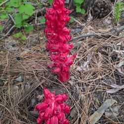
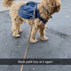
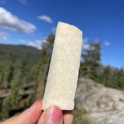
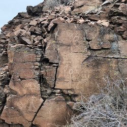
Dog Valley Photos


You might also consider
More like Dog Valley
Recommended Reviews - Dog Valley
Start your review...

This is the location of a trailhead for the Humboldt-Toiyabe National Forest http://www.fs.usda.gov/htnf/ The views are delightful... If you want to go the distance, a map or GPS unit would be a Very good idea... http://www.fs.usda.gov/main/htnf/maps-pubs It is only 6.3 million acres big! (The biggest national forest that is under federal management.) "The Carson Ranger District extends along the eastern front of the Sierra Nevada Mountains, straddling the Nevada and California border with a land base of 368,600 acres. The District is about 15 miles wide and near 100 miles long and stretches from the Dog Valley area northwest of Reno, Nevada heading south along the Carson Range, passing between Lake Tahoe and Carson City, then continuing further south to Alpine County in California and ending just north of the Sonora Pass and Highway 108 area." read more


More info about Dog Valley
Henness Pass Rd
Floriston, CA 96111
Directions
(775) 882-2766
Call Now
Hours
Outdoor Amenities
You might also consider


Dog Valley - hiking - Updated July 2026
Best of Floriston
People found Dog Valley by searching for…
Lakes in Floriston, California
Things to Do in Floriston, California
Lakes & Ponds in Floriston, California
City Pass in Floriston, California
Easy Hikes in Floriston, California
Hiking Trails in Floriston, California
Walking Trails in Floriston, California
Hiking With Kids in Floriston, California
Off Road Trails in Floriston, California
Waterfalls in Floriston, California
Playground in Floriston, California
Scenic View in Floriston, California
Running Trails in Floriston, California
Sunrise View in Floriston, California
Trails in Floriston, California
Tent Camping in Floriston, California
What to Do in Floriston, California
Restaurants in Floriston, California
Parks With Shade in Floriston, California
Off Leash Dog Hikes in Floriston, California
Browse Articles
Browse Nearby
BEST of Floriston, California Coffee near Dog Valley
BEST of Floriston, California Things to Do near Dog Valley
BEST of Floriston, California Breakfast near Dog Valley
BEST of Floriston, California Parks near Dog Valley
BEST of Floriston, California Restaurants near Dog Valley
Browse Brands
Related Searches in Floriston, CA
Affordable Kayak Rental Services in Floriston, California
Affordable Long Term RV Parking in Floriston, California
Affordable Paddle Board Rental in Floriston, California
Best Fishing Locations and Guides in Floriston, California
Best Lookout Points to Visit in Floriston, California
Best Places for Stunning Views in Floriston, California
Best Spots for Star Gazing in Floriston, California
Discover Popular Photo Spots in Floriston, California
Discover Stunning Skyline View Spots in Floriston, California
Discover the Best Night Hike Trails in Floriston, California
Effective Stairs Workout Spots in Floriston, California
Enjoy Scenic Night View Experiences in Floriston, California
Enjoy the Best Night View Spots in Floriston, California
Enjoy the Best Tubing Experiences in Floriston, California
Exciting Cliff Jumping Spots in Floriston, California
Explore Popular Campgrounds Near Floriston, California
Explore Popular RV Parks Around Floriston, California
Explore Popular View Points Around Floriston, California
Find Beautiful Views in Floriston, California
Find Cozy Camping Cabins in Floriston, California
Find the Best Fireworks Shows in Floriston, California
Must-See Tourist Attractions Around Floriston, California
Popular Outdoor Activities to Try in Floriston, California
Popular Places to Take Pictures in Floriston, California
Popular Things to Do in Floriston, California
Popular Things to See in Floriston, California
See Top Fireworks Events in Floriston, California
Top Paddleboarding Activities in Floriston, California
Top Places to Visit in Floriston, California for Sightseeing
People who viewed Dog Valley also viewed
Cross Peak Hiking Trail
16 reviews
Tahoe Pyramid Trail
2 reviews
Independence Lake Preserve
4 reviews
Upper Thomas Creek - Whites Creek - Dry Pond Trail
7 reviews
Evans Creek Trailhead
22 reviews
Michael D Thompson Trailhead
27 reviews
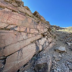
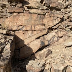
Griffith Canyon Petroglyphs
1 review
Geiger Lookout
13 reviews
Halo Trail
1 review
Tom Cooke Trail
3 reviews
Northwest Reno