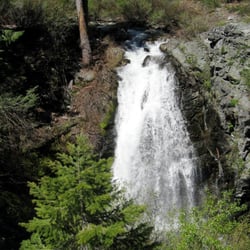
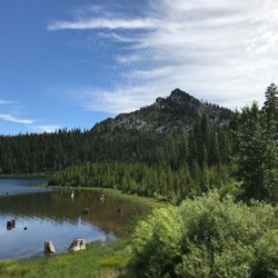
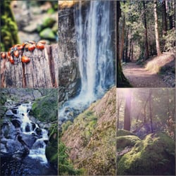
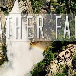
Frazier Falls Trail Photos


You might also consider
More like Frazier Falls Trail
Recommended Reviews - Frazier Falls Trail
Start your review...

Reviews With Photos - Frazier Falls Trail


We did it! Along with many other roads right now the Frazier Creek Road is mostly closed. We had to see the falls with water while in the area. So, we parked about a mile up until we could go no more due to the snow level. Yeah this was not an easy hike. Initially just had patches of snow. Then it began...hiking in all snow upward gaining in elevation. About 3 miles to the Trailhead. Then another 1/2 mile to the waterfall with the trail buried by many feet of snow. Thank You solo hiker we ran into on the way. We used his footsteps to help guide us. I regret not taking a pic of the bridge that crosses the river, and the picnic table buried in snow. The snow is melting, but not at some crazy rate on a 78 degree day. The news is nonsense. It will take some time to melt it's deep! If you dare right now, don't go late in the day. Hiking in the snow is a lot of work, and good hiking boots are best.

Easy family friendly trail about a half a mile out from the parking lot. It's a favorite of ours, providing both excitement and ease for our kids. The path is completely paved and normally very well maintained, though this visit there were some downed trees but it's still real early in the season. It is a one way road in/out, one way in is paved while the other one is off road. Parking can be tight but there is often off road parking spots within walking distance.

What a amazing little hike. With breathtaking views of a Frazier Falls. Nestled up really well maintained side road, which winds through the Sierras up to the most amazing trailhead and campgrounds. The waterfall is only about a half mile from the trailhead on paved paths, with the most quaint benches along the path. Just a spectacular campgrounds and waterfall. It reminded me of Yellowstone. This is a must see for the entire family. You absolutely want to pack a lunch and just linger and enjoy the sights and sounds of nature. I will definitely be back and would highly recommend making a trip up to Frazier Falls. Hope to see you there

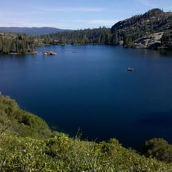
A short hike off Gold Lake Highway, about one mile round trip and paved the whole way with neat wooden benches lining the path, lies Frazier Falls. This beautiful scenic hike included mossy fallen logs and neat rock formations. The hike was easy for me...and I enjoy food more than working out!! My hubby is athletic and he found it to be extremely easy. Yet alas I found myself winded a few times going up! I said aloud, "I'm out of shape!" And my four year old says, "I'm out of a LOT of shapes mommy, I need a break!" The benches were a welcomed relief for us. At the end of the falls lies a huge metal fence and a look out towards the water falls... Which didn't have water, oops! We didn't know that the water only flows enough to make the falls in the Springtime, and we were too far into summer to see it. Therefore I suggest taking this hike early spring unless it's purely for the scenic value and not to see the water falls flowing! Nevertheless the walk was very refreshing and it felt good to get out and walk around before heading to the crystal clear water at Sand Pond! I think we may just try and come back in the spring to see the falls in all their glory.

Easy hike is made challenging by the elevation! Pristine, gorgeous trail, with a lovely payoff. This is a few miles past the state park in Graeagle. When you see the sign for the Frazier Falls turnoff, you'll drive up, up, up. The first trailhead sign you'll see is Frazier Creek (which definitely is not a paved trail) and if your GPS says you're here and you're wondering if the whole thing was a mistake, just keep driving up another 3 miles and you'll arrive at the parking lot. It's a 1 mile total loop with natural beauty that's looks so good it almost seems landscaped. Nice thing about being paved is you can enjoy the surroundings without looking down at your feet while walking!

WOW! What a nice trail. From the "Gold Lake Highway" turn off by Gold Lake it is 1 1/2 miles on gravel to the parking area/trailhead. There is a pair of restrooms there and some information signage as well. The trail is completely paved with smooth asphalt. The sign stated that the falls are 1/2 mile from the trailhead but it sure seemed shorter than that! The trail is built for foot traffic, and wheelchair access also. It is very flat and easy going. The scenery is beautiful! Granite rock, lots of greenery, and tall mountains. At one point you walk over a wonderfully built bridge. Underneath, in the spring time, I'm sure that the creek bed is flowing with lots of icy cold snow melt. Unfortunately for us, it's late in the season and there was no water at all.:( We continued to walk until we finally came to an area that opens up to a huge gorge! Like the rest of this trail, there are called guard rails set up so everyone is completely safe. There is a sign that explains about the falls, the terrain, and ancient glaciers. I could only imagine what the falls look like in early spring time when the creek is full! I certainly plan on coming back next spring, to see these majestic Falls! It's pretty amazing even when dry! Don't forget your camera!

We were visiting Nakoma Lodge Resort from Reno, and Frazier Falls was recommended to visit while we were up here. It was about 20 away from the lodge on a Thursday morning. There was a little construction. About 1 hour 8 minutes (GPS time) from center of Reno. ***something to note, there are at least two ways to get to Frazier Falls, we missed the first turn off coming SB 89 - you make a WB turn onto Gold Lake Hwy, and the turn off is pretty close. Since we missed it, GPS rerouted us to go another 6.8 miles and instead of trying to turn around on the thin shoulder, we just decided to continue on. Well this ended up being a mistake, because we got much higher in elevation and there was still snow along the entrance and on the path to get to the Falls that way. (June 1, but it was a heavy winter) We parked to see if we could walk it and decided that we were not going to walk 1.5 miles half snow half muddy dirt. We decided to turn back around and try to go in the first one. This worked much better, however the drive is a one lane road that has some scary drop offs and curves, so pay attention and go slow. 4 miles up the road takes a good 10-15 minutes with barely any other cars (thankfully) Once we got to the parking lot (which seemed just a dream at the beginning of the road) the entry to the trailhead is right in front of you. It is paved all the way to the falls, which perhaps was 1/2 a mile up in a back and forth windy path. Beautiful scenery along the way, lots of photo ops, but obviously the best part was getting to the view of the Falls. Very very pretty! Flowing very well due to the heavy winter. The best waterfall I have actually ever seen in my limited traveling to waterfall experiences. Oh it was so pretty! Good little place to visit if you enjoy nature for sure. and you Should. Life is short!

If you're looking for an easy hike with outstanding scenic views, this is the one for you. The Frazier Falls Trail is a PAVED 1 mile out and back trail (1/2 mile out + 1/2 mile back). As it is paved, it is even accessible by wheelchair. Elevation: ~6,200 ft. Difficulty: Easy Hiking Season: May to November Gold Lake Highway intersects with Highway 89 approximately 48 miles North of Truckee (1 1/2 miles South of Graeagle). Take the Gold Lake Highway for 1.6 miles and watch for a turnoff on the left which is marked "Frazier Falls 4". Turn here, and be aware that the next 4+ miles can be challenging in the early or late season when there may still be snow present at the higher elevations. Go 4.2 miles to a parking lot from which the trailhead is accessible.

Want a pretty view with a relatively short walk? This is the trail for you! I'm not really a hiker but this wasn't really a hike. The path is paved the entire way to the view of the falls. The trail is half a mile so you complete a full mile on a trip out and back. This will feel like nothing at all because there is so much to look at along the way. There are even benches along the trail to stop for a breather or to enjoy the scenery. A cute little bridge on the trail allows a good view of the water rushing by to the top of the falls. The view of the actual falls is breathtaking and I couldn't have picked better weather that day! There was a light breeze at the top of the trail that felt nice. I loved walking along taking pictures as I continued on the path both to and from the falls. This area is just so scenic! There are bathrooms at the very beginning of this trail but keep in mind you are in a national park, there is no running water! Be sure to pack your hand sanitizer. While there is a trail is it a bit narrow and I saw a couple struggling with a double stroller along the path. This is definitely more suited for a single stroller. You will also have to step to the side to let groups pass by you. Heads up: The road up to the trail head is narrow and pretty winding so keep an eye and ear out for other cars because some parts of this road are not wide enough to allow passing. It is only a single lane so be careful and observant!

Very accessible and easy trail as it was paved and only about half a mile. A little too easy for us but the falls were beautiful in late April. Seems like it was one of the only trails in the area that wasn't blocked off by snow. We wished the trail had continued down to the base of the falls.

I'm fully in my hiking/camping era at this point, so we decided to take a short drive and check out Frazier Falls. And honestly? This is my kind of hike. It's about a mile, easy, and paved, so you're not out there fighting for your life...but still has a high payoff at the end, which is really all I'm asking for these days When we got there, the waterfall was actually flowing, which always feels like a win. And on the way back, we cut through some rocks and were able to see where the waterfall starts, which made it even cooler. If you're nearby in early spring, I highly recommend checking out Frazier Falls. Easy, quick, and worth it...basically the perfect low-effort, high-reward hike. read more


16 days ago
Frazier Falls Trail was absolutely beautiful and perfect for families. The trail is easy to follow with very few inclines, making it enjoyable for hikers of all ages and skill levels. The scenery along the way is gorgeous, and the highlight is the stunning waterfall waiting at the end of the trail. The park is well-maintained, with clean bathrooms conveniently located near the parking lot and picnic tables available for enjoying lunch before or after your hike. Overall, it's a relaxing and rewarding outdoor experience that I would highly recommend for anyone looking for an easy, family-friendly adventure. read more


3 years ago
This was a beautiful trail it was a short easy hike that had kids, dogs and people with physical challenges. Though the water fall was not raging. The scenic walk was well worth it. Everyone we passed was friendly on the trail. read more


9 months ago
1 year ago
3 years ago
We did it! Along with many other roads right now the Frazier Creek Road is mostly closed. We had to see the falls with water while in the area. So, we parked about a mile up until we could go no more due to the snow level. Yeah this was not an easy hike. Initially just had patches of snow. Then it began...hiking in all snow upward gaining in elevation. About 3 miles to the Trailhead. Then another 1/2 mile to the waterfall with the trail buried by many feet of snow. Thank You solo hiker we ran into on the way. We used his footsteps to help guide us. I regret not taking a pic of the bridge that crosses the river, and the picnic table buried in snow. The snow is melting, but not at some crazy rate on a 78 degree day. The news is nonsense. It will take some time to melt it's deep! If you dare right now, don't go late in the day. Hiking in the snow is a lot of work, and good hiking boots are best. read more

4 years ago
Easy family friendly trail about a half a mile out from the parking lot. It's a favorite of ours, providing both excitement and ease for our kids. The path is completely paved and normally very well maintained, though this visit there were some downed trees but it's still real early in the season. It is a one way road in/out, one way in is paved while the other one is off road. Parking can be tight but there is often off road parking spots within walking distance. read more


What a amazing little hike. With breathtaking views of a Frazier Falls. Nestled up really well maintained side road, which winds through the Sierras up to the most amazing trailhead and campgrounds. The waterfall is only about a half mile from the trailhead on paved paths, with the most quaint benches along the path. Just a spectacular campgrounds and waterfall. It reminded me of Yellowstone. This is a must see for the entire family. You absolutely want to pack a lunch and just linger and enjoy the sights and sounds of nature. I will definitely be back and would highly recommend making a trip up to Frazier Falls. Hope to see you there read more


10 years ago
A short hike off Gold Lake Highway, about one mile round trip and paved the whole way with neat wooden benches lining the path, lies Frazier Falls. This beautiful scenic hike included mossy fallen logs and neat rock formations. The hike was easy for me...and I enjoy food more than working out!! My hubby is athletic and he found it to be extremely easy. Yet alas I found myself winded a few times going up! I said aloud, "I'm out of shape!" And my four year old says, "I'm out of a LOT of shapes mommy, I need a break!" The benches were a welcomed relief for us. At the end of the falls lies a huge metal fence and a look out towards the water falls... Which didn't have water, oops! We didn't know that the water only flows enough to make the falls in the Springtime, and we were too far into summer to see it. Therefore I suggest taking this hike early spring unless it's purely for the scenic value and not to see the water falls flowing! Nevertheless the walk was very refreshing and it felt good to get out and walk around before heading to the crystal clear water at Sand Pond! I think we may just try and come back in the spring to see the falls in all their glory. read more


8 years ago
Easy hike is made challenging by the elevation! Pristine, gorgeous trail, with a lovely payoff. This is a few miles past the state park in Graeagle. When you see the sign for the Frazier Falls turnoff, you'll drive up, up, up. The first trailhead sign you'll see is Frazier Creek (which definitely is not a paved trail) and if your GPS says you're here and you're wondering if the whole thing was a mistake, just keep driving up another 3 miles and you'll arrive at the parking lot. It's a 1 mile total loop with natural beauty that's looks so good it almost seems landscaped. Nice thing about being paved is you can enjoy the surroundings without looking down at your feet while walking! read more


WOW! What a nice trail. From the "Gold Lake Highway" turn off by Gold Lake it is 1 1/2 miles on gravel to the parking area/trailhead. There is a pair of restrooms there and some information signage as well. The trail is completely paved with smooth asphalt. The sign stated that the falls are 1/2 mile from the trailhead but it sure seemed shorter than that! The trail is built for foot traffic, and wheelchair access also. It is very flat and easy going. The scenery is beautiful! Granite rock, lots of greenery, and tall mountains. At one point you walk over a wonderfully built bridge. Underneath, in the spring time, I'm sure that the creek bed is flowing with lots of icy cold snow melt. Unfortunately for us, it's late in the season and there was no water at all.:( We continued to walk until we finally came to an area that opens up to a huge gorge! Like the rest of this trail, there are called guard rails set up so everyone is completely safe. There is a sign that explains about the falls, the terrain, and ancient glaciers. I could only imagine what the falls look like in early spring time when the creek is full! I certainly plan on coming back next spring, to see these majestic Falls! It's pretty amazing even when dry! Don't forget your camera! read more


We were visiting Nakoma Lodge Resort from Reno, and Frazier Falls was recommended to visit while we were up here. It was about 20 away from the lodge on a Thursday morning. There was a little construction. About 1 hour 8 minutes (GPS time) from center of Reno. ***something to note, there are at least two ways to get to Frazier Falls, we missed the first turn off coming SB 89 - you make a WB turn onto Gold Lake Hwy, and the turn off is pretty close. Since we missed it, GPS rerouted us to go another 6.8 miles and instead of trying to turn around on the thin shoulder, we just decided to continue on. Well this ended up being a mistake, because we got much higher in elevation and there was still snow along the entrance and on the path to get to the Falls that way. (June 1, but it was a heavy winter) We parked to see if we could walk it and decided that we were not going to walk 1.5 miles half snow half muddy dirt. We decided to turn back around and try to go in the first one. This worked much better, however the drive is a one lane road that has some scary drop offs and curves, so pay attention and go slow. 4 miles up the road takes a good 10-15 minutes with barely any other cars (thankfully) Once we got to the parking lot (which seemed just a dream at the beginning of the road) the entry to the trailhead is right in front of you. It is paved all the way to the falls, which perhaps was 1/2 a mile up in a back and forth windy path. Beautiful scenery along the way, lots of photo ops, but obviously the best part was getting to the view of the Falls. Very very pretty! Flowing very well due to the heavy winter. The best waterfall I have actually ever seen in my limited traveling to waterfall experiences. Oh it was so pretty! Good little place to visit if you enjoy nature for sure. and you Should. Life is short! read more


6 years ago
If you're looking for an easy hike with outstanding scenic views, this is the one for you. The Frazier Falls Trail is a PAVED 1 mile out and back trail (1/2 mile out + 1/2 mile back). As it is paved, it is even accessible by wheelchair. Elevation: ~6,200 ft. Difficulty: Easy Hiking Season: May to November Gold Lake Highway intersects with Highway 89 approximately 48 miles North of Truckee (1 1/2 miles South of Graeagle). Take the Gold Lake Highway for 1.6 miles and watch for a turnoff on the left which is marked "Frazier Falls 4". Turn here, and be aware that the next 4+ miles can be challenging in the early or late season when there may still be snow present at the higher elevations. Go 4.2 miles to a parking lot from which the trailhead is accessible. read more


Want a pretty view with a relatively short walk? This is the trail for you! I'm not really a hiker but this wasn't really a hike. The path is paved the entire way to the view of the falls. The trail is half a mile so you complete a full mile on a trip out and back. This will feel like nothing at all because there is so much to look at along the way. There are even benches along the trail to stop for a breather or to enjoy the scenery. A cute little bridge on the trail allows a good view of the water rushing by to the top of the falls. The view of the actual falls is breathtaking and I couldn't have picked better weather that day! There was a light breeze at the top of the trail that felt nice. I loved walking along taking pictures as I continued on the path both to and from the falls. This area is just so scenic! There are bathrooms at the very beginning of this trail but keep in mind you are in a national park, there is no running water! Be sure to pack your hand sanitizer. While there is a trail is it a bit narrow and I saw a couple struggling with a double stroller along the path. This is definitely more suited for a single stroller. You will also have to step to the side to let groups pass by you. Heads up: The road up to the trail head is narrow and pretty winding so keep an eye and ear out for other cars because some parts of this road are not wide enough to allow passing. It is only a single lane so be careful and observant! read more


8 years ago
Very accessible and easy trail as it was paved and only about half a mile. A little too easy for us but the falls were beautiful in late April. Seems like it was one of the only trails in the area that wasn't blocked off by snow. We wished the trail had continued down to the base of the falls. read more


7 years ago
7 years ago
12 years ago
The Frazier Falls Trial is beautiful vistas, clean air and easy access for a nice family outing. The scenery was absolutely gorgeous. It's a geologic paradise. The trail is 1/2 mile easy hike. You will see the munificent Frazier Falls at the end of the trial. This is a must visit place of you're in the Portola area. read more


11 years ago
10 years ago
Well no water falling on July 28th BUT it was a nice nature hike with my Pal Max. I need to come back when the water is flowing! read more


9 years ago
10 years ago
9 years ago
14 years ago
More info about Frazier Falls Trail
Gold Lake Hwy
Graeagle, CA 96103
Directions
Hours
Outdoor Amenities
Ask the Community - Frazier Falls Trail
Review Highlights - Frazier Falls Trail


Frazier Falls Trail - hiking - Updated July 2026
Best of Graeagle
People found Frazier Falls Trail by searching for…
Things to Do in Graeagle, California
Campgrounds in Graeagle, California
Hiking Trails With Waterfalls in Graeagle, California
Off Road Trails in Graeagle, California
Waterfalls and Swimming Holes in Graeagle, California
Scenic View in Graeagle, California
View Points in Graeagle, California
Scenic Drive in Graeagle, California
Waterfalls in Graeagle, California
Dog Friendly Hiking Trails in Graeagle, California
Camping Sites in Graeagle, California
Beautiful Views in Graeagle, California
Picnic Spots in Graeagle, California
Scenic Overlook in Graeagle, California
Walking Trails in Graeagle, California
Lakes & Ponds in Graeagle, California
Fun Things to Do With Kids in Graeagle, California
Natural Hot Springs in Graeagle, California
Places to Visit in Graeagle, California
Trending Searches in Graeagle, CA
Cliff Jumping near Frazier Falls Trail
Fireworks near Frazier Falls Trail
Kayak Rental near Frazier Falls Trail
Off Road Trails near Frazier Falls Trail
Public Shower near Frazier Falls Trail
River Swimming near Frazier Falls Trail
River Tubing near Frazier Falls Trail
Splash Pad near Frazier Falls Trail
Swimming Holes near Frazier Falls Trail
Browse Articles
Browse Nearby
BEST of Graeagle, California Coffee near Frazier Falls Trail
BEST of Graeagle, California Parks near Frazier Falls Trail
BEST of Graeagle, California Things to Do near Frazier Falls Trail
BEST of Graeagle, California Restaurants near Frazier Falls Trail
BEST of Graeagle, California Swimming Holes near Frazier Falls Trail
BEST of Graeagle, California Breakfast near Frazier Falls Trail
BEST of Graeagle, California Hot Springs near Frazier Falls Trail
BEST of Graeagle, California Campgrounds near Frazier Falls Trail
BEST of Graeagle, California Sledding near Frazier Falls Trail
Browse Brands
Related Searches in Graeagle, CA
Best Fishing Locations and Guides in Graeagle, California
Best Off Leash Dog Parks in Graeagle, California
Best Places for Horseback Riding in Graeagle, California
Best Sledding Spots and Fun in Graeagle, California
Best Waterfalls and Swimming Holes in Graeagle, California
Check Out Off Road Trails in Graeagle, California
Discover Dog Friendly Trails to Explore in Graeagle, California
Discover Kid Friendly Hiking Trails in Graeagle, California
Discover a Hiking Trail in Graeagle, California
Dog-Friendly Hikes With Dogs in Graeagle, California
Enjoy Camping Adventures Around Graeagle, California
Enjoy Exciting Mountain Biking Adventures in Graeagle, California
Enjoy River Tubing Adventures in Graeagle, California
Enjoy a Beautiful Waterfall Hike in Graeagle, California
Enjoy the Best Tubing Experiences in Graeagle, California
Exciting Cliff Jumping Spots in Graeagle, California
Experience Stunning Sunset Views in Graeagle, California
Explore Bike Rentals Throughout Graeagle, California
Explore Easy Hikes Perfect for All in Graeagle, California
Explore Fun Activities to Do in Graeagle, California
Explore Jet Skis for Sale or Rent in Graeagle, California
Explore Popular Campgrounds Near Graeagle, California
Explore Popular RV Parks Around Graeagle, California
Explore Scenic Lakes to Visit in Graeagle, California
Explore Top Dog Parks in Graeagle, California Near You
Explore the Best Boating Spots in Graeagle, California
Explore the Best Swimming Holes Around Graeagle, California
Find Beautiful Views in Graeagle, California
Find Cozy Camping Cabins in Graeagle, California
Find Fun Things to Do With Kids in Graeagle, California
Find Popular Ziplining Spots Around Graeagle, California
Find Top Dog Swimming Spots in Graeagle, California
Find Top Skate Parks in Graeagle, California for All Skill Levels
Find Top-Rated Disc Golf in Graeagle, California
Find the Best Playgrounds to Visit in Graeagle, California
Hiking Trails With Waterfalls in Graeagle, California
Locate a Public Shower Facility in Graeagle, California
Off Leash Dog Hiking Trails in Graeagle, California
Popular Kids Activities in Graeagle, California
Popular Picnic Spots to Visit in Graeagle, California
Popular Things to Do in Graeagle, California
Relax at Natural Hot Springs Near Graeagle, California
Top Climbing Spots and Gyms in Graeagle, California
Top Paddleboarding Activities in Graeagle, California
Top Running Trails to Explore in Graeagle, California
Top Swimming Lakes to Enjoy in Graeagle, California
Top Swimming Spots and Pools in Graeagle, California
Top Things to Do With Kids in Graeagle, California
People who viewed Frazier Falls Trail also viewed
Jamison Creek Lower Falls Trail
2 reviews
Madora Lake Loop Trail
3 reviews
Upper Salmon Lake Trail to Deer Lake and Summit Lake
1 review
Buck's Lake
10 reviews
Portola Riverwalk
5 reviews
Crystal Mine
2 reviews
Coburn Trail
1 review
Explore! Sierra Touring Company
36 reviews
Gold Lake Stable & Pack Station
9 reviews
Greenhorn Ranch
53 reviews