Jamison Mine Trailhead Photos


You might also consider
More like Jamison Mine Trailhead
Recommended Reviews - Jamison Mine Trailhead
Start your review...

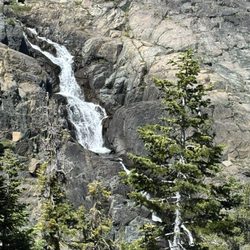
Best part of this trip! Please wear shoes as the rocks and gravel can be slippery. Must take your time getting to this area but worth it. There's a rope section to get up/down to the waterfall. Kids had a blast jumping off the rocks. Water was cold but the kids had too much fun. Plenty of parking Not crowded which is always a plus. read more


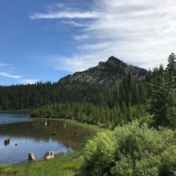
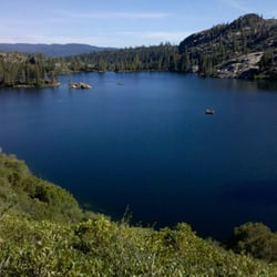
To get there: You can turn from CA-89 onto Johnsville Rd. and it is approximately 4.6 miles to Jamison Mine Rd on the left. The trailhead parking area is 1.3 miles from the turnoff. The trail: From the parking area you'll see the trail and you'll go up to an old mine building and the trail goes to the left. The climb is moderate but partially shaded. If you go to Jamison and Rock Lakes you'll have an elevation gain of about 1100' to 1400' depending if you make it a loop and check out Wades Lake. We ended up exploring different areas and clocked 9.15 miles. This trail is extremely rewarding with a good workout, beautiful views, excellent cool lakes to swim in, and friendly people. read more


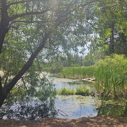
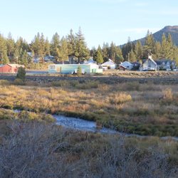
This trailhead can be reached in two ways--by driving down a dirt road BEFORE the entrance to Plumas-Eureka SP, or by hiking to it from Upper Jamison Creek CG, INSIDE of the park. Either way, you will end up in a flat, gravelly parking area near several old mining buildings. This trail will take you to three lakes--Grass, Rock, and Jamison--and also leads deeper into the Lakes Basin Recreation Area if you are looking for a longer hike. The start of this trail is just miserable. A treacherous, rocky uphill scramble past lots of old mining stuff. Push through it, though, and after the initial climb the trail becomes far more scenic. Early in the season, much of the trail will be underwater, but all of the creeks and streams make for a very pleasant hike. Past Grass Lake, though, snow lingers until early July, so be careful. Although this is a beautiful hike, it really needs some TLC. There were several downed trees blocking the trail, including one that landed right across a log-bridge, making the creek crossing very treacherous. Hopefully the forest service will do some maintenance soon. read more
11 years ago
14 years ago
14 years ago
More info about Jamison Mine Trailhead
Jamison Mine Rd
Johnsville, CA 96103
Directions
Hours
Outdoor Amenities
Ask the Community - Jamison Mine Trailhead


Jamison Mine Trailhead - hiking - Updated July 2026
Best of Johnsville
People found Jamison Mine Trailhead by searching for…
Fishing in Johnsville, California
Things to Do in Johnsville, California
Hiking Trails With Waterfalls in Johnsville, California
Parks in Johnsville, California
Swimming Lakes in Johnsville, California
Off Road Trails in Johnsville, California
River Swimming in Johnsville, California
Waterfalls and Swimming Holes in Johnsville, California
Scenic View in Johnsville, California
Scenic Drive in Johnsville, California
Scenic Overlook in Johnsville, California
Snow in Johnsville, California
Waterfalls in Johnsville, California
View Points in Johnsville, California
Beautiful Views in Johnsville, California
Swimming in Johnsville, California
Secret Spots in Johnsville, California
Fishing Lake in Johnsville, California
Places to Visit in Johnsville, California
What to Do in Johnsville, California
Kids in Johnsville, California
Rock in Johnsville, California
Trending Searches in Johnsville, CA
Browse Articles
Browse Nearby
BEST of Johnsville, California Restaurants near Jamison Mine Trailhead
BEST of Johnsville, California Things to Do near Jamison Mine Trailhead
BEST of Johnsville, California Lakes near Jamison Mine Trailhead
BEST of Johnsville, California Swimming Holes near Jamison Mine Trailhead
BEST of Johnsville, California Breakfast near Jamison Mine Trailhead
BEST of Johnsville, California Lunch near Jamison Mine Trailhead
BEST of Johnsville, California Sledding near Jamison Mine Trailhead
Browse Brands
Related Searches in Johnsville, CA
Best Fishing Locations and Guides in Johnsville, California
Best Nature Trails for Hiking in Johnsville, California
Best Sledding Spots and Fun in Johnsville, California
Best Spots for Star Gazing in Johnsville, California
Best Waterfalls and Swimming Holes in Johnsville, California
Check Out Off Road Trails in Johnsville, California
Discover Dog Friendly Beaches Near Johnsville, California
Discover Popular Bike Trails in Johnsville, California
Discover Popular Photo Spots in Johnsville, California
Discover Scenic Mountain Bike Trails Near Johnsville, California
Discover Stunning Skyline View Spots in Johnsville, California
Discover Top Nature Parks to Visit in Johnsville, California
Discover a Hiking Trail in Johnsville, California
Discover the Best Running Track in Johnsville, California
Dog-Friendly Hikes With Dogs in Johnsville, California
Enjoy Scenic Night View Experiences in Johnsville, California
Enjoy Tent Camping Spots Around Johnsville, California
Enjoy a Beautiful Waterfall Hike in Johnsville, California
Enjoy the Best Night View Spots in Johnsville, California
Enjoy the Best Picnic Spots and Ideas in Johnsville, California
Enjoy the Best Walking Trails in Johnsville, California
Exciting Cliff Jumping Spots in Johnsville, California
Explore Beautiful Parks and Green Spaces in Johnsville, California
Explore Free Things to Do Around Johnsville, California
Explore Popular Campgrounds Near Johnsville, California
Explore Popular Scenic Overlook Points in Johnsville, California
Explore Scenic Lakes to Visit in Johnsville, California
Explore Secret Spots Worth Visiting in Johnsville, California
Explore Top Dog Parks in Johnsville, California Near You
Explore the Best Swimming Holes Around Johnsville, California
Explore the Best Trail Options in Johnsville, California
Family Friendly Hiking With Kids in Johnsville, California
Find Fun Kids Activities Outdoor in Johnsville, California
Find Parks and Recreation Activities in Johnsville, California
Find the Best Scenic View Locations in Johnsville, California
Hiking Trails With Waterfalls in Johnsville, California
Must-See Tourist Attractions Around Johnsville, California
Off Leash Dog Hiking Trails in Johnsville, California
Perfect Spots to Watch Sunset in Johnsville, California
Picnic Areas With BBQ Pits Available in Johnsville, California
Plan a Scenic Drive Route Near Johnsville, California
Popular Fishing Spots to Explore in Johnsville, California
Popular Picnic Spots to Visit in Johnsville, California
Popular Things to Do in Johnsville, California
Safe River Swimming Areas in Johnsville, California
Top Running Trails to Explore in Johnsville, California
Top Swimming Lakes to Enjoy in Johnsville, California
Top Swimming Spots and Pools in Johnsville, California
Top Things to Do With Teenagers in Johnsville, California
Uncover the Best Secluded Spots Around Johnsville, California
People who viewed Jamison Mine Trailhead also viewed
Jamison Creek Lower Falls Trail
2 reviews
Madora Lake Loop Trail
3 reviews
Upper Salmon Lake Trail to Deer Lake and Summit Lake
1 review
Buck's Lake
10 reviews
Crystal Mine
2 reviews
Coburn Trail
1 review
Explore! Sierra Touring Company
36 reviews
Greenhorn Ranch
53 reviews
Gold Lake Stable & Pack Station
9 reviews
Downieville Mountain Bike Trails
3 reviews