Crystal Mine Photos


You might also consider
More like Crystal Mine
Recommended Reviews - Crystal Mine
Start your review...

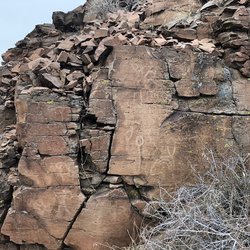
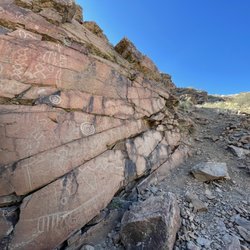
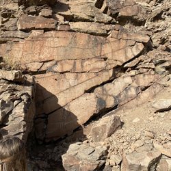
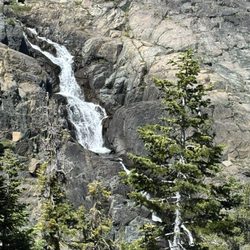
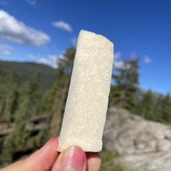
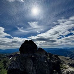
My wife and I have been doing some more remote exploring since we purchased a used Jeep and this place was close to home and on our list. The Loyalton address on Yelp is a little deceiving. Loyalton is a nearby town but we accessed it via Exit 3 at Bordertown at the California/Nevada state line. We've also heard it can be accessed from Verdi but heard the road(s) are more difficult. Our experience today is that you will need a 4x4 - we saw various 4x4's from newer to older - we personally wouldn't take our newer truck up there. From the Forest service website: The Crystal Mine gets its name from the crystals that were mined here. During World War II crystals were needed in abundance for use in two-way radios. Dynamite was used to blast the hillside and bring the crystals to the surface. It is still possible to find nice whole crystals in the blast remnants; though it takes some work. Digging and collecting is allowed. You are allowed to remove one 5-pound bucket of crystals per week. It's about 15 miles from the exit at Bordertown but plan on it taking 45+ minutes from the highway to get there - your not going above 20 MPH at any time. The scenery on the way is pretty and you begin to see pine trees approximately half way up. There are signs posted that indicate the road is closed at the first snowfall of the year and remains closed throughout the winter. We were really impressed and amazed at the amount of quarts and crystals - wow! This is a great place if you are an amateur rock hunters like we are or if you have kids - we imagine they would love it! The views from atop the peak are beautiful as well. You will want to pack some gloves, tools for digging and a bucket for collecting. We also wish we would have had something to wipe our hands up with - since we didn't take any gloves. Next time - we will pack these things and probably a picnic lunch and spend more time there. Great experience and so close to Reno! We highly recommend! read more


15 years ago
More info about Crystal Mine
Loyalton, CA 96118
Directions
Hours
Outdoor Amenities


Crystal Mine - hiking - Updated July 2026
Best of Loyalton
People found Crystal Mine by searching for…
Things to Do in Loyalton, California
Hiking Trails in Loyalton, California
Off Road Trails in Loyalton, California
Beautiful Views in Loyalton, California
View Points in Loyalton, California
Scenic Overlook in Loyalton, California
Waterfalls in Loyalton, California
Scenic Views in Loyalton, California
Hiking Trails Kid Friendly in Loyalton, California
Swimming Holes in Loyalton, California
Tent Camping in Loyalton, California
Hiking With Kids in Loyalton, California
Off Leash Dog Hikes in Loyalton, California
Camping Sites in Loyalton, California
Dog Friendly Trails in Loyalton, California
New Businesses in Loyalton, California
Running Trails in Loyalton, California
Fishing Spots in Loyalton, California
Trending Searches in Loyalton, CA
4th Of July Fireworks near Crystal Mine
Cliff Jumping near Crystal Mine
Dog Friendly Trails near Crystal Mine
Jet Ski Rental near Crystal Mine
Kayak Rental near Crystal Mine
Lakes & Ponds near Crystal Mine
Off Road Trails near Crystal Mine
Outdoor Activities near Crystal Mine
Public Pools near Crystal Mine
Public Shower near Crystal Mine
River Swimming near Crystal Mine
Scenic Night View near Crystal Mine
Scenic Overlook near Crystal Mine
Secluded Spots near Crystal Mine
Soccer Store near Crystal Mine
Strawberry Picking near Crystal Mine
Sunrise View near Crystal Mine
Swimming Holes near Crystal Mine
Swimming Lakes near Crystal Mine
U Pick Farms near Crystal Mine
Browse Articles
Browse Nearby
BEST of Loyalton, California Things to Do near Crystal Mine
BEST of Loyalton, California Coffee near Crystal Mine
BEST of Loyalton, California Parks near Crystal Mine
BEST of Loyalton, California Restaurants near Crystal Mine
BEST of Loyalton, California Lakes near Crystal Mine
BEST of Loyalton, California Campgrounds near Crystal Mine
Browse Brands
Related Searches in Loyalton, CA
Affordable Kayak Rental Services in Loyalton, California
Best Fishing Locations and Guides in Loyalton, California
Best Places for Horseback Riding in Loyalton, California
Best Waterfalls and Swimming Holes in Loyalton, California
Check Out Off Road Trails in Loyalton, California
Discover Dog Friendly Trails to Explore in Loyalton, California
Discover Popular Photo Spots in Loyalton, California
Discover Scenic Mountain Bike Trails Near Loyalton, California
Discover a Hiking Trail in Loyalton, California
Discover the Best Night Hike Trails in Loyalton, California
Discover the Best Running Track in Loyalton, California
Dog-Friendly Hikes With Dogs in Loyalton, California
Enjoy Camping Adventures Around Loyalton, California
Enjoy Exciting Mountain Biking Adventures in Loyalton, California
Enjoy Tent Camping Spots Around Loyalton, California
Enjoy the Best Picnic Spots and Ideas in Loyalton, California
Enjoy the Best Tubing Experiences in Loyalton, California
Enjoy the Best Walking Path in Loyalton, California
Enjoy the Best Walking Trails in Loyalton, California
Exciting Cliff Jumping Spots in Loyalton, California
Experience Stunning Sunset Views in Loyalton, California
Explore Beautiful Parks and Green Spaces in Loyalton, California
Explore Bike Rentals Throughout Loyalton, California
Explore Easy Hikes Perfect for All in Loyalton, California
Explore Fun Activities to Do in Loyalton, California
Explore Popular Campgrounds Near Loyalton, California
Explore Popular RV Parks Around Loyalton, California
Explore Popular Scenic Overlook Points in Loyalton, California
Explore Popular View Points Around Loyalton, California
Explore Scenic Lakes to Visit in Loyalton, California
Explore the Best Beach Spots in Loyalton, California
Explore the Best Boating Spots in Loyalton, California
Explore the Best Swimming Holes Around Loyalton, California
Explore the Scenic River in Loyalton, California
Family Friendly Hiking With Kids in Loyalton, California
Find Parks and Recreation Activities in Loyalton, California
Find the Best Playgrounds to Visit in Loyalton, California
Find the Best Scenic View Locations in Loyalton, California
Hiking Trails With Waterfalls in Loyalton, California
Off Leash Dog Hiking Trails in Loyalton, California
Plan a Scenic Drive Route Near Loyalton, California
Popular Outdoor Activities to Try in Loyalton, California
Popular Things to Do in Loyalton, California
Safe River Swimming Areas in Loyalton, California
Safe and Fun Parks for Kids in Loyalton, California
Top Climbing Spots and Gyms in Loyalton, California
Top Places for Snorkeling in Loyalton, California
Top Running Trails to Explore in Loyalton, California
People who viewed Crystal Mine also viewed
Steamboat Ditch Trail
6 reviews
Bear Lakes & Long Lake Loop Trail
14 reviews
Grasshopper Flat Campground
12 reviews
Jamison Mine Trailhead
6 reviews
Lake Davis Recreation Area
5 reviews
Webber Lake Campground
3 reviews
Verdi East Trail
4 reviews
Tahoe Pyramid Bikeway Verdi Upstream Section
2 reviews
Forest Park
1 review
North Valleys
Northridge Park
1 review
Northwest Reno