Castle Peak Photos


You might also consider
More like Castle Peak
Recommended Reviews - Castle Peak
Start your review...

Reviews With Photos

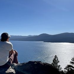
this is an amazing hike in the sierras, with pretty decent elevation gain on loose gravel. come early in the morning for one of many parking spots and bring some bug spray for the 1st 2 miles since you are in a shaded area with still water. also recommend bringing hiking poles for the climb down so you are not slipping and sliding everywhere. the views are phenomenal and you will see through hikers on the PCT, the PCT is easily accessible from this hike. the hikers are friendly here and at the top of castle peak, there is generally a group that congregates up at the top and socialize and give tips for other hikes in the area. You should be in decent shape to make it up to the top of castle peak and not be entirely exhausted, but the views are totally worth it.

One of my favorite hike in Tahoe National Park ! Sure it's about 5.5 miles RT but it's quite a workout with the elevations gains and loose rocks but definetly worth it with all the stunning gorgeous view on top ! Will be back read more


Excellent hiking trail, except for about the first one quarter. All trails rates this as a hard Trail. What makes the trail hard is the continuous uphill grade, and about the last half mile. Just take your time, we're good hiking shoes, and bring water. You'll be fine. I did the hike mid October 2020. It was about 60 degrees at the trailhead, but the wind at the peak was at least 35 miles an hour. And it was cold. I went from short sleeves and short pants to a warm coat with a hood. I can't imagine doing this Trail in the snow, although apparently that's a thing. As with most steep trails, the trip up is tiring and the trip down is a constant battle with slipping. there's tons of cool geology along this Trail, although there isn't a lot written about it. Read up on the general geology of the Donner Pass area. read more


8 years ago
Being from the south, I definitely wasn't used to the elevation here. So this hike was a challenge! It was well worth it though for the views and the workout. I suggest wearing sturdy shoes and starting early in the morning... hiking under the sun was NOT fun! Also, there's lots of loose gravel, but I found having a walking stick helped. read more


13 years ago
this is an amazing hike in the sierras, with pretty decent elevation gain on loose gravel. come early in the morning for one of many parking spots and bring some bug spray for the 1st 2 miles since you are in a shaded area with still water. also recommend bringing hiking poles for the climb down so you are not slipping and sliding everywhere. the views are phenomenal and you will see through hikers on the PCT, the PCT is easily accessible from this hike. the hikers are friendly here and at the top of castle peak, there is generally a group that congregates up at the top and socialize and give tips for other hikes in the area. You should be in decent shape to make it up to the top of castle peak and not be entirely exhausted, but the views are totally worth it. read more


9 years ago
11 years ago
This is a pretty butt kicking hike! It starts out easy and really picks up in elevation. I actually wish I brought poles because there's a lot of loose gravel towards the end. When you finally get towards the top, you can hike over to the east turret and it can be easily climbed with tennis shoes. That being said, you need to be in decent shape and not too afraid of heights. Once you get to the top of that turret there is a marker for the peak, be proud! This is NOT a good hike if you are looking for something leisurely. It's a fairly advanced hike that requires good balance and stamina. It took my boyfriend and I about 5 hours to get to the east turret peak and back (we enjoyed a sandwich somewhere along the way). That being said, anyone can make it into an enjoyable hike. It starts out easy, and increases in difficulty as you progress. So if you find yourself too exhausted to make it allllll the way up top, just enjoy whatever portion of the hike that you wish. There's many trails shooting off of the main trail to the peak. Have fun! read more


More info about Castle Peak
Truckee, CA 96161
Directions
Hours
Outdoor Amenities
Ask the Community - Castle Peak
You might also consider


Castle Peak - hiking - Updated July 2026
Best of Truckee
People found Castle Peak by searching for…
Snow Play in Truckee, California
Hiking Trails in Truckee, California
Things to Do in Truckee, California
Off Road Trails in Truckee, California
Easy Hikes in Truckee, California
Hiking With Kids in Truckee, California
Playgrounds in Truckee, California
Sunrise Hike in Truckee, California
Walking Trails in Truckee, California
Parks for Kids in Truckee, California
Tent Camping in Truckee, California
Waterfalls in Truckee, California
Running Trails in Truckee, California
Playgrounds for Kids in Truckee, California
View Points in Truckee, California
Hiking Trails Kid Friendly in Truckee, California
Scenic View in Truckee, California
Trending Searches in Truckee, CA
4th Of July Fireworks near Castle Peak
Black Owned Nail Salons near Castle Peak
Cliff Jumping near Castle Peak
Dog Friendly Trails near Castle Peak
Jet Ski Rental near Castle Peak
Lakes & Ponds near Castle Peak
Outdoor Activities near Castle Peak
Parks For Picnics near Castle Peak
Public Shower near Castle Peak
River Swimming near Castle Peak
Scenic Night View near Castle Peak
Scenic Overlook near Castle Peak
Secluded Spots near Castle Peak
Strawberry Picking near Castle Peak
Swimming Holes near Castle Peak
Browse Articles
Browse Nearby
BEST of Truckee, California Coffee near Castle Peak
BEST of Truckee, California Restaurants near Castle Peak
BEST of Truckee, California Breakfast near Castle Peak
BEST of Truckee, California Things to Do near Castle Peak
BEST of Truckee, California Shopping near Castle Peak
BEST of Truckee, California Sledding near Castle Peak
BEST of Truckee, California Campgrounds near Castle Peak
Browse Brands
Related Searches in Truckee, CA
Affordable Kayak Rental Services in Truckee, California
Best Fishing Locations and Guides in Truckee, California
Best Places for Horseback Riding in Truckee, California
Best Sledding Spots and Fun in Truckee, California
Check Out Off Road Trails in Truckee, California
Discover Dog Friendly Trails to Explore in Truckee, California
Discover Scenic Bike Paths in Truckee, California
Discover Scenic Mountain Bike Trails Near Truckee, California
Discover a Hiking Trail in Truckee, California
Discover the Best Night Hike Trails in Truckee, California
Dog-Friendly Hikes With Dogs in Truckee, California
Enjoy Camping Adventures Around Truckee, California
Enjoy Exciting Mountain Biking Adventures in Truckee, California
Enjoy Kayaking Adventures in Truckee, California
Enjoy Tent Camping Spots Around Truckee, California
Enjoy a Beautiful Waterfall Hike in Truckee, California
Enjoy the Best Picnic Spots and Ideas in Truckee, California
Enjoy the Best Tubing Experiences in Truckee, California
Enjoy the Best Walking Path in Truckee, California
Enjoy the Best Walking Trails in Truckee, California
Exciting Cliff Jumping Spots in Truckee, California
Experience Thrilling White Water Rafting in Truckee, California
Explore Beautiful Parks and Green Spaces in Truckee, California
Explore Easy Hikes Perfect for All in Truckee, California
Explore Fun Activities to Do in Truckee, California
Explore Popular Campgrounds Near Truckee, California
Explore the Best Beach Spots in Truckee, California
Explore the Best Boating Spots in Truckee, California
Explore the Best Swimming Holes Around Truckee, California
Explore the Best Trail Options in Truckee, California
Family Friendly Hiking With Kids in Truckee, California
Find Beautiful Views in Truckee, California
Find Popular Ziplining Spots Around Truckee, California
Find the Best Parks for Picnics in Truckee, California
Find the Best Scenic View Locations in Truckee, California
Great Places to Walk in Truckee, California
Hiking Trails With Waterfalls in Truckee, California
Off Leash Dog Hiking Trails in Truckee, California
Plan a Scenic Drive Route Near Truckee, California
Play at a Splash Pad Park in Truckee, California
Popular Outdoor Activities to Try in Truckee, California
Popular Picnic Spots to Visit in Truckee, California
Safe River Swimming Areas in Truckee, California
Safe and Fun Parks for Kids in Truckee, California
Top Climbing Spots and Gyms in Truckee, California
Top Places for Snorkeling in Truckee, California
Top Running Trails to Explore in Truckee, California
Top Swimming Spots and Pools in Truckee, California
People who viewed Castle Peak also viewed
Tahoe Rim Trail to Picnic Rock Viewpoint
16 reviews
Pacific Crest Trail
3 reviews
Sierra Discovery Trail
6 reviews
Marlette lake trail
6 reviews
Spooner Lake Trailhead
19 reviews
Independence Lake Preserve
4 reviews
Loch Leven Lakes Trail
19 reviews
Northstar Bike Park
8 reviews
Euchre Bar Trail
6 reviews
Thunder Mountain Hike
2 reviews