Loch Leven Lakes Trail Photos


You might also consider
More like Loch Leven Lakes Trail
Recommended Reviews - Loch Leven Lakes Trail
Start your review...

Reviews With Photos

Loch Leven Lakes Trail is a pretty easy hike for anyone to complete. The three lakes that are along this trail are all incredibly beautiful and well preserved. At the beginning of the hike, it is really easy to lose track of the trail but you usually end up back on the trail as long as you keep going up the rocks. The trail between the lakes is pretty mild. If you enjoy camping, you can pitch a tent pretty much anywhere along the trail. The weather here in the summer is mild: warm days and cool nights. The water in the lakes is really clean and I highly recommend jumping in for a swim! The trail between the lakes is marked well and the signs are easy to follow. This is a beautiful trail just outside of Reno and it makes for a fun day trip.

Challenging but well worth the hike! I hiked this trail today on July 4, and I was surprised that there weren't more hikers. My friend and I eventually teamed up with two guys who had two dogs. They had previously done the hike which was great since a few trail sections weren't clearly marked. Many people on AllTrails say that the trail needs maintenance, but it really isn't too too bad. I almost didn't go based on these comments. There are fallen trees and logs, but they are easy to get around. There are areas that are quite vague regarding where the trail continues, and they tend to be where you climb on the granite. Look for the trail cairns as they helped us many times. The hike to the high lake (3rd and last lake) was well worth it. After the 1-mile hike to the railroad tracks, you then start the rocky switchback section that eventually levels out before the first lake. This almost-constant uphill section with continuous rockiness makes me believe that the trail is moderate-to-hard. You then hike another mile or so to the third lake. We also swam to the island and the water was perfect temperature. I should note that there was a garter snake that swam in front of me, but thankfully my fellow hiker did not mention it until I was completely out of the water. I'd recommend hiking boots on the trail due to the rocks, climbing the granite rocks at an angle, and crossing several muddy and wet spots. If you're not in shape and decide to hike, you may want to go at a slow and steady pace. We spent 2.5 hours each way and spent an hour swimming and eating at the lake. Also, remember to bring looootttssss of water! I packed 80 ounces and finished it as I walked toward the car.

This was an amazing trail. The level is Difficult for a reason, but it was well worth it. It is very hard finding the beginning of the trail (took us 30m). The trail begins directly across from the restrooms (Fancy Outhouses) and starts up towards the left. The trail had more rocks than dirt, so hiking shoes are a better fit, but mine did just fine. It's best to get there early (by 8a) it's a short trail of 8 mi. Round trip if you visit all 3 lakes. But the incline and rocks makes it feel like "forever". It is 1.1 mi. To the historic train tracks (Great Photo Op) none of the trail is "flat", it's all ascending and steep. An additional 2.2 mi takes you to the 1st Lake which is pretty, but keep walking (15m-20m) and you'll find the best of the 3 lakes. The third Lake is .7 mi & is where a lot of people camp at. We didn't see any wild life but saw a few lizards. Ascending is a lot quicker & we were able to enjoy the views. I definitely recommend.

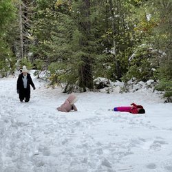
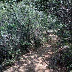
While Sacramento was experiencing 105 degrees this weekend, we decided to run for the hills to hopefully cool off. Upon arrival and throughout the hike, we experienced 90 degree temperatures that were not as cool as we had hoped, and to put it frankly, was very hot. This being said, we brought plenty of water to last us for the duration of the afternoon, so that was a great start! The trail elevations range from 5680 to 6850 feet, so please be aware of this before approaching from the Sacramento valley. Also, this hike is listed as Sacramento, but is actually about 1 hour and 15 minutes away...so it is actually closer to Truckee off of I-80. The hike itself is a classic Tahoe forest trail including junipers, pines, and ferns. Bluebird days bring summer wildflowers like columbine, asters, and wild snapdragon. Beautiful views and clear lakes are up there waiting for you! However, let's take a few minutes to make you aware of some things that you may not have prepared for. First off, this is a dog-friendly trail, and only one of the many dogs we happened across was on-leash. Today, we saw just as many dogs swimming in the lakes as we did humans. Secondly, the trail itself is not clearly marked from either direction. While there are a few wooden signs nailed to trees saying, "trail", many of the directional trail markers are cairns that folks have left to hopefully point the way. We did get lost a few times, as the trail wandered through expansive unmarked granite slabs. Leaving middle lake to get to upper lake left us on a different adventure altogether, but we stayed level-headed and pushed forward. Lastly, if you have bad knees or ankles, this may not be the best hike for you. The moderate rating includes lots of steep uphill with switchbacks, making for steep downhills on the way back out. Altogether, the trail is 7.2 miles long total to upper lake (3.6 miles out, and 3.6 miles back). Get there early, be prepared, and wear good hiking shoes. Bring your trekking poles if you need them. All this being said, we had a nice time and really loved the scenery and smells that Loch Leven Lakes had to offer. We also realized that this would be a great place to ease into preparing yourself for some longer backpacking trips, so get out there and enjoy it too!

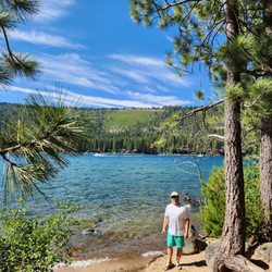
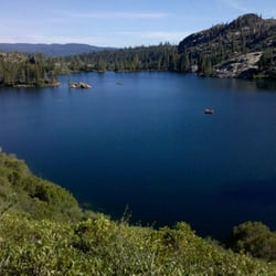
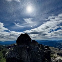
If told to "Take a hike" and "go jump in a lake", I will gladly get off your nerves and go away. Needing to go away on a late summer afternoon, I took that hike and jumped in that lake on the Loch Leven Lakes trail. The hike is an 8 mile (12.9 km) round-trip, climbing 1,100 feet (335 m) of elevation, to a chain of three scenic alpine lakes. The trail traverses polished granite outcrops, passes cascading pools, and crosses a wooden bridge spanning a rushing creek. Abruptly, the course of the original Transcontinental Railroad severs the path. At the crossing, an overhead signal structure spans the operating tracks. Two hikers had boldly climbed the ladder and were standing on the catwalk directly over a formidable freight train as it lumbered up the grade. Alarmingly, the double-stacked container cars passed a mere 6 inches beneath their feet. Across the tracks, the trail climbs punishingly for 30 minutes over rocky switchbacks. Over the ridge, the string of three clear lakes weaves through the glaciated landscape. Upper Loch Leven Lake is a small mirror lake. Middle Loch Leven Lake, the largest, is set in a rock amphitheater and dotted with pine-studded islands. High Loch Leven Lake, like Goldilocks, was just right for a refreshing plunge. I leapt off a smooth granite ledge on the west side of the lake. First, I screamed for a cardiologist, but I soon became invigorated. Afterward, I dried off and caught my breath on the radiant slab of igneous rock. The conveniently located hike and revitalizing swim took a total of 4 hours to complete. I will gladly return to the Loch Leven Lakes trail, any time someone tells me to "take a hike" and "go jump in a lake". Directions: The trailhead is about 75 miles (120 km) east of downtown Sacramento, on the south side of I-80, between Exits 166 and 168, on Hampshire Rocks Road (Old Highway 40), about 1/2-mile (0.8 km) west of the Rainbow Lodge. The trail begins across the road from the small parking lot and vault toilets.

This trail is not for beginners. It's very difficult. You are walking up rocks at high elevation and steep inclines. But this trail is worth it. If you have the stamina and you exercise regularly this is so worth it. The lake at then end of the trail is beautiful. The huge rocks and boulders are majestic and the weather was perfect. We went in early September and it was beautiful. It wasn't too heavily populated but there were others out there. Dogs are allowed on this trail and it was so fun to see them out there. Wear hiking boots with grips on the bottom. If you have walking poles bring them! Bring extra water and take snacks, you will be burning a lot of calories and sweat on this trail and you will need your energy to make it back in of the down hill. Truly a beautiful trail.

11 months ago
Awesome trail as always. It's easy to get a bit lost on the beginning as there are lots of little side trails off here and there. GPS is helpful for this. It's a steady climb up to the first lake. Cool crossing over the train tracks. You do hear I-80 for a lot of the hike even when it's mikes away so it's not a remote hike at all. read more


3 years ago
Loch Leven trail begins at Placer County Road and ends at High Loch Leven Lake in the Tahoe National Forest. It is about 8 mile out-and-back trail near Soda Springs, California. The trail begins 200 yards east of the Big Bend Fire Station on old U.S. 40 (Big Bend exit off I-80). A restroom is available at the trailhead. The trail begins across the road from the parking area. A designated parking lot is limited but parking is available along the road. Hiking can be challenging due to its high elevation and heat. I would rate this hiking trail as moderate as the trail works its way upward on a moderately steep climb. Granite outcroppings and glacial erratic starts along the first portion of the route, and the trail can be difficult to follow on the bare rock sections. The trail is a bit difficult to find at times but you can look for enough signs and cairns displayed by previous hikers. Don't get lost. Look carefully for the hiking trail! As the trail ascends, it crosses minor hogbacks and depressions, generally trending upward. Prior to the railroad tracks, you see the markers for a buried telephone trunk line, and petroleum pipeline that they cross. Near the tracks, a small bridge spans a creek that flows swift and cold in early season. Be careful with the train tracks. Don't get trapped! The railroad tracks are on the original 1860s route of the Central Pacific railroad, built by hand with Chinese labor. It is still a major freight and passenger route in and out of California as I saw two long trains passing by. After crossing the tracks, the trail becomes steeper, going from 6,000' to 6,800' in 1.25 miles. At the top of the ridge, the trail descends gradually into the Loch Leven lakes basin. The trail in the basin is primarily level, but follows the topography. At the south end of lower Loch Leven, a trail junction continues left to middle and high Lochs, or right to Salmon Lake. Fishing is good, and camping is dispersed throughout the basin. Campfire permits are required for campfires, backpacking stoves, BBQs, and lanterns. It took us about 5.5 hours to complete, including breaks, and time to enjoy the lakes. I would start around 8am although we did not get to the trail head until 1030am. There are plenty of cool tree shades and tree tunnels It seems to be popular for backpacking, camping, and fishing, so we encountered other people while hiking. The best times to visit this trail are May through October. Dogs are welcome, but must be on a leash. Please pick up all your poop bags. Garbage in, garbage out please. Sun block, mosquito repellent, and adequate hydration and food snacks are definitely important! We must try our best to keep nature is clean and stay beautiful! Magic is definitely here!! read more


6 years ago
This is a fantastic beginning backpacking experience if you're an experienced hiker. But if you have little to no hiking experience, I'd pass on this one. AllTrails has the mileage wrong (it's actually 7.2 miles RT, not 8.8) and has it rated as moderate. With the steep elevation gain that starts from a quarter mile in and doesn't stop until you reach the first lake, the extremely rocky terrain (you're scrambling over slippery slabs of granite at some points) and the ease to which one could get lost, I'd say this is more moderate-difficult. Unfortunately this trail is completely unmaintained and the erosion from recent years of heavy rainfall has clearly taken it's toll. The friend I backpacked with had done this trail before as a day hike some years back and noted the difference over time. If you're backpacking this one and carrying gear, start super early for a few reasons: 1. Parking is free, with limited lot spaces and is mostly along the street. If you come late you might not get a spot. 2. This is an extremely popular trail, heavily trafficked, and hard to maintain social distancing. You'll spend extra time stopping in places to let people safely pass with social distance (assuming you have some trail etiquette). 3. The terrain is mixed from arid, full sun exposure over granite boulders to partially shaded forest and very rocky (think creekbed). If you get to the bridge over the creek and are exhausted, turn around because the most challenging terrain is yet to come. Of course the big payday are the three pristine lakes. Although my friend and I had a great time camping out by the third one (Upper Loch Leven) we both agreed we'd prefer to come back to camp and swim at the second one, which is much larger and has more little islands throughout. Once you get up to the second or third lake it's all worth it! read more


 - Hiking Near Me - Emigrant Gap, California")


Loch Leven Lakes Trail is a pretty easy hike for anyone to complete. The three lakes that are along this trail are all incredibly beautiful and well preserved. At the beginning of the hike, it is really easy to lose track of the trail but you usually end up back on the trail as long as you keep going up the rocks. The trail between the lakes is pretty mild. If you enjoy camping, you can pitch a tent pretty much anywhere along the trail. The weather here in the summer is mild: warm days and cool nights. The water in the lakes is really clean and I highly recommend jumping in for a swim! The trail between the lakes is marked well and the signs are easy to follow. This is a beautiful trail just outside of Reno and it makes for a fun day trip. read more


Challenging but well worth the hike! I hiked this trail today on July 4, and I was surprised that there weren't more hikers. My friend and I eventually teamed up with two guys who had two dogs. They had previously done the hike which was great since a few trail sections weren't clearly marked. Many people on AllTrails say that the trail needs maintenance, but it really isn't too too bad. I almost didn't go based on these comments. There are fallen trees and logs, but they are easy to get around. There are areas that are quite vague regarding where the trail continues, and they tend to be where you climb on the granite. Look for the trail cairns as they helped us many times. The hike to the high lake (3rd and last lake) was well worth it. After the 1-mile hike to the railroad tracks, you then start the rocky switchback section that eventually levels out before the first lake. This almost-constant uphill section with continuous rockiness makes me believe that the trail is moderate-to-hard. You then hike another mile or so to the third lake. We also swam to the island and the water was perfect temperature. I should note that there was a garter snake that swam in front of me, but thankfully my fellow hiker did not mention it until I was completely out of the water. I'd recommend hiking boots on the trail due to the rocks, climbing the granite rocks at an angle, and crossing several muddy and wet spots. If you're not in shape and decide to hike, you may want to go at a slow and steady pace. We spent 2.5 hours each way and spent an hour swimming and eating at the lake. Also, remember to bring looootttssss of water! I packed 80 ounces and finished it as I walked toward the car. read more


This was an amazing trail. The level is Difficult for a reason, but it was well worth it. It is very hard finding the beginning of the trail (took us 30m). The trail begins directly across from the restrooms (Fancy Outhouses) and starts up towards the left. The trail had more rocks than dirt, so hiking shoes are a better fit, but mine did just fine. It's best to get there early (by 8a) it's a short trail of 8 mi. Round trip if you visit all 3 lakes. But the incline and rocks makes it feel like "forever". It is 1.1 mi. To the historic train tracks (Great Photo Op) none of the trail is "flat", it's all ascending and steep. An additional 2.2 mi takes you to the 1st Lake which is pretty, but keep walking (15m-20m) and you'll find the best of the 3 lakes. The third Lake is .7 mi & is where a lot of people camp at. We didn't see any wild life but saw a few lizards. Ascending is a lot quicker & we were able to enjoy the views. I definitely recommend. read more


3 years ago
7 years ago
While Sacramento was experiencing 105 degrees this weekend, we decided to run for the hills to hopefully cool off. Upon arrival and throughout the hike, we experienced 90 degree temperatures that were not as cool as we had hoped, and to put it frankly, was very hot. This being said, we brought plenty of water to last us for the duration of the afternoon, so that was a great start! The trail elevations range from 5680 to 6850 feet, so please be aware of this before approaching from the Sacramento valley. Also, this hike is listed as Sacramento, but is actually about 1 hour and 15 minutes away...so it is actually closer to Truckee off of I-80. The hike itself is a classic Tahoe forest trail including junipers, pines, and ferns. Bluebird days bring summer wildflowers like columbine, asters, and wild snapdragon. Beautiful views and clear lakes are up there waiting for you! However, let's take a few minutes to make you aware of some things that you may not have prepared for. First off, this is a dog-friendly trail, and only one of the many dogs we happened across was on-leash. Today, we saw just as many dogs swimming in the lakes as we did humans. Secondly, the trail itself is not clearly marked from either direction. While there are a few wooden signs nailed to trees saying, "trail", many of the directional trail markers are cairns that folks have left to hopefully point the way. We did get lost a few times, as the trail wandered through expansive unmarked granite slabs. Leaving middle lake to get to upper lake left us on a different adventure altogether, but we stayed level-headed and pushed forward. Lastly, if you have bad knees or ankles, this may not be the best hike for you. The moderate rating includes lots of steep uphill with switchbacks, making for steep downhills on the way back out. Altogether, the trail is 7.2 miles long total to upper lake (3.6 miles out, and 3.6 miles back). Get there early, be prepared, and wear good hiking shoes. Bring your trekking poles if you need them. All this being said, we had a nice time and really loved the scenery and smells that Loch Leven Lakes had to offer. We also realized that this would be a great place to ease into preparing yourself for some longer backpacking trips, so get out there and enjoy it too! read more


11 years ago
If told to "Take a hike" and "go jump in a lake", I will gladly get off your nerves and go away. Needing to go away on a late summer afternoon, I took that hike and jumped in that lake on the Loch Leven Lakes trail. The hike is an 8 mile (12.9 km) round-trip, climbing 1,100 feet (335 m) of elevation, to a chain of three scenic alpine lakes. The trail traverses polished granite outcrops, passes cascading pools, and crosses a wooden bridge spanning a rushing creek. Abruptly, the course of the original Transcontinental Railroad severs the path. At the crossing, an overhead signal structure spans the operating tracks. Two hikers had boldly climbed the ladder and were standing on the catwalk directly over a formidable freight train as it lumbered up the grade. Alarmingly, the double-stacked container cars passed a mere 6 inches beneath their feet. Across the tracks, the trail climbs punishingly for 30 minutes over rocky switchbacks. Over the ridge, the string of three clear lakes weaves through the glaciated landscape. Upper Loch Leven Lake is a small mirror lake. Middle Loch Leven Lake, the largest, is set in a rock amphitheater and dotted with pine-studded islands. High Loch Leven Lake, like Goldilocks, was just right for a refreshing plunge. I leapt off a smooth granite ledge on the west side of the lake. First, I screamed for a cardiologist, but I soon became invigorated. Afterward, I dried off and caught my breath on the radiant slab of igneous rock. The conveniently located hike and revitalizing swim took a total of 4 hours to complete. I will gladly return to the Loch Leven Lakes trail, any time someone tells me to "take a hike" and "go jump in a lake". Directions: The trailhead is about 75 miles (120 km) east of downtown Sacramento, on the south side of I-80, between Exits 166 and 168, on Hampshire Rocks Road (Old Highway 40), about 1/2-mile (0.8 km) west of the Rainbow Lodge. The trail begins across the road from the small parking lot and vault toilets. read more


This trail is not for beginners. It's very difficult. You are walking up rocks at high elevation and steep inclines. But this trail is worth it. If you have the stamina and you exercise regularly this is so worth it. The lake at then end of the trail is beautiful. The huge rocks and boulders are majestic and the weather was perfect. We went in early September and it was beautiful. It wasn't too heavily populated but there were others out there. Dogs are allowed on this trail and it was so fun to see them out there. Wear hiking boots with grips on the bottom. If you have walking poles bring them! Bring extra water and take snacks, you will be burning a lot of calories and sweat on this trail and you will need your energy to make it back in of the down hill. Truly a beautiful trail. read more


13 years ago
Great Full day hike! We got to the trailhead around noon and came back at 8 granted that we spent more than 2 hours near the lake and swam in middle and high lake. It is true that it is easy to get confused where the trail is at the beginning but it's not that hard to figure out. read more


8 years ago
8 years ago
13 years ago
11 years ago
11 years ago
More info about Loch Leven Lakes Trail
Ask the Community - Loch Leven Lakes Trail
Review Highlights - Loch Leven Lakes Trail
You might also consider


Loch Leven Lakes Trail - hiking - Updated May 2026
Best of Emigrant Gap
People found Loch Leven Lakes Trail by searching for…
Campgrounds in Emigrant Gap, California
Snow Play in Emigrant Gap, California
Hiking Trails in Emigrant Gap, California
Fishing in Emigrant Gap, California
Things to Do in Emigrant Gap, California
Swimming Lakes in Emigrant Gap, California
Rock Climbing in Emigrant Gap, California
Scenic View in Emigrant Gap, California
Dog Swimming in Emigrant Gap, California
Photo Spots in Emigrant Gap, California
Easy Hikes in Emigrant Gap, California
Off Road Trails in Emigrant Gap, California
Dog Friendly Hiking Trails in Emigrant Gap, California
Star Gazing in Emigrant Gap, California
View Points in Emigrant Gap, California
Hiking With Kids in Emigrant Gap, California
Watch Sunset in Emigrant Gap, California
Gold Panning in Emigrant Gap, California
Fishing Lake in Emigrant Gap, California
Redwood Trees in Emigrant Gap, California
Camping Sites in Emigrant Gap, California
Views in Emigrant Gap, California
Browse Nearby
BEST of Emigrant Gap, California Coffee near Loch Leven Lakes Trail
BEST of Emigrant Gap, California Restaurants near Loch Leven Lakes Trail
BEST of Emigrant Gap, California Things to Do near Loch Leven Lakes Trail
BEST of Emigrant Gap, California Lakes near Loch Leven Lakes Trail
BEST of Emigrant Gap, California Fishing near Loch Leven Lakes Trail
BEST of Emigrant Gap, California Breakfast near Loch Leven Lakes Trail
BEST of Emigrant Gap, California Hotels near Loch Leven Lakes Trail
BEST of Emigrant Gap, California Campgrounds near Loch Leven Lakes Trail
BEST of Emigrant Gap, California Sledding near Loch Leven Lakes Trail
Browse Brands
Browse Articles
People who viewed Loch Leven Lakes Trail also viewed
Pacific Crest Trail
3 reviews
Stateline Lookout Trail
32 reviews
Shirley Lake Trail
55 reviews
Donner Pass Railroad Tunnel Hike
50 reviews
Castle Peak
8 reviews
Donner Memorial State Park
169 reviews
Donner Lake
77 reviews
Sawtooth Trail
3 reviews
Hell Hole Reservoir
3 reviews
Von Schmidt Monument Historic Park
5 reviews