Bear Lakes & Long Lake Loop Trail Photos


You might also consider
More like Bear Lakes & Long Lake Loop Trail
Recommended Reviews - Bear Lakes & Long Lake Loop Trail
Start your review...

Reviews With Photos

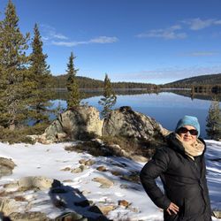
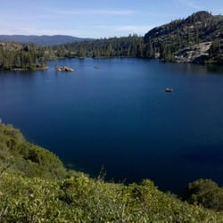
Beautiful views! If you live within 2 hours of this hike, it is worth the drive. Make a day out of it and try the Village Baker! We started from the Gold Lake Lodge trail head and arrived at about 8:30. There were 4 other people there and they started the hike just a few minutes before us but were really quick so other than them- we didn't encounter any other people until we were looping back to the parking lot. When we did get back to the parking lot there were tons of cars and people just starting the hike so I definitely suggest getting there early! The hike is moderate and elevation changes are pretty easy. The views are so worth it! I am not going to go into great detail because you really need to go see it for yourself. Check out my photos if you need anymore convincing. I'm only sharing 2 of over 50 (FIFTY) that I took. It was that beautiful! We hiked a total of 5 miles and it took us 2 hrs 24 mins BUT we took a longer way back to the parking lot than intended (oops). It just gave us a little more scenery to enjoy, so oh well! I think overall the hike would've been about 4 miles had we taken a left when we took a right.

One of the most scenic hikes in the area. Deserves six stars. Breathtaking views, flora, and fauna during our hike (7/9/17 after an epic winter). The map at the trailhead isn't correct as far as the scale listed which I think is the cause of the disagreement between some of the reviewers. For instance, if you leave the trailhead to go to Big Bear Lake first instead of Long Lake one sign says "3/4 of a mile". There is NO WAY that was accurate. More like 1 3/4 of a mile. I agree with one poster who pegs this hike at 4 1/2 miles total. Being from Reno we are used to very cold water if we want to do any swimming, but I was SHOCKED at how warm Big Bear Lake was. Explains the *snake* I saw swimming by when I was cooling my feet off in the water. Dampened any further urges to take a dip... If you have someone in from out of town this is a must see. Lots of "easies", but the payoff is huge.

Super easy ramble up and down and around several lakes. The wildflowers are showing off with a miriad of colors and varieties. A tad busy as we were leaving...parking lot completely full at 1pm and bikers on the trail..but we were on our way off the mountain. Do friendly. Clean oit toilet. Wear a suit and jump in any number of lakes.

About 105 miles from Reno with spectacular views of three major mountain ranges coming together. It's a excellent place to view a variety of wildlife. The views are nothing short of fabulous. The area is home to bald eagles, but we didn't any the day we were there. The hike from the trailhead is easy to moderate, down a very well maintained trails. With the ivy as ground cover, along with the whispering aspen turning bright yellow, there I thought it resembled a enchanted forest more than just a ordinary hike. We only hiked about 2 miles in, turning around just past Cab Lake. Just a knock your socks off kinda day. Enjoy

This is one of my favorite hikes near Graeagle, CA in the Lakes Basin Area. The hike is a 2 1/2 mile loop that includes very beautiful scenic views of 4 alpine lakes - Big Bear Lake, Little Bear Lake, Cub Lake, and Long Lake. Elevation: ~6,700 ft. Difficulty: Moderate Hiking Season: May through October Gold Lake Highway intersects with Highway 89 approximately 48 miles North of Truckee (1 1/2 miles South of Graeagle). Drive 6.6 miles down the Gold Lake Highway to the Lakes Basin Campground. Take this narrow road .9 miles to the trailhead parking lot. (Note: keep going past the sign to the Elwell Lodge and also past the entry to the Lakes Basin Campground).

Absolutely breathtakingly, beautiful day hike in Graeagle Lakes Basin Area that is not quite 2 hours from the Carson City area. Easy directions that has signs that will guide you right to the trailhead with as the other reviewers noted very limited parking but this hike is WELL worth it. With your choice of going to fish at Long Lake or hiking on several different hiking options from the Bear Lakes & Long Lake Loop Trail or take in a more moderate to difficult hike up to Mt. Elwell or Pacific Crest Trail you will not be disappointed by the beautiful nature views plus the four alpine lakes that on this trip in November we weren't brave enough to take a dip in but our Hobey doggy thoroughly enjoyed and we found to be of temperature similar to Lake Tahoe. Big Bear, Little Bear, Cub and Long Lake were exactly what we needed to put us back in touch with the serene vibes of the peacefulness of being outside with nature. Weather, views were stunningly gorgeous, we and our furry companions HIGHLY recommend getting out here to enjoy this easy to moderate hike/loop trail. Enjoy and #moveyourbody !! read more


5 years ago
I feel like nothing I write will adequately describe the beauty of this place, so I'll let the pictures do the talking for that part. The trailhead is easy to find and off the main road. The road to get to the trailhead is doable in a small car, but take it slow as there are potholes and lots of blind corners. There's a well-maintained bathroom at the start of the trail and good signage. Parking is pretty good, there were plenty of spaces when I went but i could see it getting crowded during the summer months. The trail to long lake is relatively easy, but I wouldn't suggest it for someone with limited mobility. It's also a short hike with almost immediate payoff once you get to long lake, which is BEAUTIFUL. My dog and I elected to keep going past long lake toward the dam, and passed several small pretty lakes and streams on the way there. The trail was a little icy when I went in early December, but nothing too crazy. read more

 - Hiking Near Me - Graeagle, California")

Wow! Anything I could say about this trail would be an understatement. Long lake is so breathtaking, peaceful, relaxing, and enjoyable. My husband, pup, and I had such a wonderful experience on this trail. I'm so excited to share my photos and hopefully encourage people to do this trail when they are in the area. This is completely worth it and an easy hike that just about any skill level can appreciate. We started around 1pm and felt the parking situation was so hectic and that we might just skip it. I am so glad that we turned around and made a parking spot work because it was a great experience to see these gorgeous lakes. My 20 lb Yorkiepoo was so happy the whole time and he enjoyed himself as much as we did. He did great and really enjoyed being in the water, he laid on a rock submerged in water for at least 10 minutes, cooling off and enjoying himself. I did the hike in chacos and socks. Usually I am strictly a hiking boot kind of girl because I just to be able to bounce from rock to rock or have the confidence that my feet are protected from things. I only had my chacos though because this was a spontaneous hike and I did great in them. Although the trail can be quite rocky at times, I didn't find that I had any problems with hiking in chacos and honestly felt more free. I stick my Chaco clothed feet right into the lake water and it was incredible, an experience I wouldn't had had in hiking boots. All this to say, lace up your shoes, or tighten your chacos and get out on this trail. Bring a book, a dog, swimsuit, a friend, and drawing book and pencil, a journal, anything! And be rejuvenated on this beautiful hike. read more


9 years ago
8 years ago
Beautiful views! If you live within 2 hours of this hike, it is worth the drive. Make a day out of it and try the Village Baker! We started from the Gold Lake Lodge trail head and arrived at about 8:30. There were 4 other people there and they started the hike just a few minutes before us but were really quick so other than them- we didn't encounter any other people until we were looping back to the parking lot. When we did get back to the parking lot there were tons of cars and people just starting the hike so I definitely suggest getting there early! The hike is moderate and elevation changes are pretty easy. The views are so worth it! I am not going to go into great detail because you really need to go see it for yourself. Check out my photos if you need anymore convincing. I'm only sharing 2 of over 50 (FIFTY) that I took. It was that beautiful! We hiked a total of 5 miles and it took us 2 hrs 24 mins BUT we took a longer way back to the parking lot than intended (oops). It just gave us a little more scenery to enjoy, so oh well! I think overall the hike would've been about 4 miles had we taken a left when we took a right. read more


9 years ago
One of the most scenic hikes in the area. Deserves six stars. Breathtaking views, flora, and fauna during our hike (7/9/17 after an epic winter). The map at the trailhead isn't correct as far as the scale listed which I think is the cause of the disagreement between some of the reviewers. For instance, if you leave the trailhead to go to Big Bear Lake first instead of Long Lake one sign says "3/4 of a mile". There is NO WAY that was accurate. More like 1 3/4 of a mile. I agree with one poster who pegs this hike at 4 1/2 miles total. Being from Reno we are used to very cold water if we want to do any swimming, but I was SHOCKED at how warm Big Bear Lake was. Explains the *snake* I saw swimming by when I was cooling my feet off in the water. Dampened any further urges to take a dip... If you have someone in from out of town this is a must see. Lots of "easies", but the payoff is huge. read more

Super easy ramble up and down and around several lakes. The wildflowers are showing off with a miriad of colors and varieties. A tad busy as we were leaving...parking lot completely full at 1pm and bikers on the trail..but we were on our way off the mountain. Do friendly. Clean oit toilet. Wear a suit and jump in any number of lakes. read more


About 105 miles from Reno with spectacular views of three major mountain ranges coming together. It's a excellent place to view a variety of wildlife. The views are nothing short of fabulous. The area is home to bald eagles, but we didn't any the day we were there. The hike from the trailhead is easy to moderate, down a very well maintained trails. With the ivy as ground cover, along with the whispering aspen turning bright yellow, there I thought it resembled a enchanted forest more than just a ordinary hike. We only hiked about 2 miles in, turning around just past Cab Lake. Just a knock your socks off kinda day. Enjoy read more


This is one of my favorite hikes near Graeagle, CA in the Lakes Basin Area. The hike is a 2 1/2 mile loop that includes very beautiful scenic views of 4 alpine lakes - Big Bear Lake, Little Bear Lake, Cub Lake, and Long Lake. Elevation: ~6,700 ft. Difficulty: Moderate Hiking Season: May through October Gold Lake Highway intersects with Highway 89 approximately 48 miles North of Truckee (1 1/2 miles South of Graeagle). Drive 6.6 miles down the Gold Lake Highway to the Lakes Basin Campground. Take this narrow road .9 miles to the trailhead parking lot. (Note: keep going past the sign to the Elwell Lodge and also past the entry to the Lakes Basin Campground). read more


11 years ago
Easily one of the best hikes in the area, and a couple different ways to do it. My favorite starts at the trailhead at the Gold Lake Lodge turnoff from Gold Lake Highway. Find the trail that heads toward Round Lake Mine (a solid inclined hike up about 500 feet, if my math is right). At the top, you'll find the abandoned mine, a bunch of scrap metal, and a beautiful, unmatched view over Round Lake. From there, take the trail to the right downhill to Round Lake itself (as opposed to the trail to the left, which continues on up to the Pacific Crest Trail). Facing Round Lake, hang a right and follow the lake counter-clockwise until Silver Lake. At Silver Lake, there are a ton of great swimming holes. From Silver Lake, head towards the Bear Lakes (cub, little bear, and big bear), and you'll catch an amazing view of Long Lake along the way. Wrap around Big Bear and head back uphill toward your original starting point. Favorite lake? Big Bear, no question. Once you've done this trail a couple of times, the insider tip is to make your way around the *inside* of Big Bear instead of following the normal trail around the outside. Tons of little coves to swim in and rocks to dive off of. Look for the highest point on the rocks surrounding the lake -- there's a single tree perched right on top -- that's what you want to aim for. This is a 4.5 mile loop by my calculation (Joel E.'s review describes a 2.5 mile loop... not sure why we have different numbers). This is a perfect "full day" hike -- not really a full day, but you can easily use up a full day if you stop and swim a lot. read more

4 years ago
8 years ago
14 years ago
More info about Bear Lakes & Long Lake Loop Trail
Gold Lake Hwy
Graeagle, CA 96103
Directions
Hours
Outdoor Amenities
Ask the Community - Bear Lakes & Long Lake Loop Trail
Review Highlights - Bear Lakes & Long Lake Loop Trail


Bear Lakes & Long Lake Loop Trail - hiking - Updated July 2026
Best of Graeagle
People found Bear Lakes & Long Lake Loop Trail by searching for…
Swimming Holes in Graeagle, California
Fishing in Graeagle, California
Campgrounds in Graeagle, California
Things to Do in Graeagle, California
Hiking Trails in Graeagle, California
Swimming Lakes in Graeagle, California
River Swimming in Graeagle, California
Off Road Trails in Graeagle, California
Scenic View in Graeagle, California
Scenic Drive in Graeagle, California
Camping Sites in Graeagle, California
Beautiful Views in Graeagle, California
Swimming in Graeagle, California
Dog Friendly Trails in Graeagle, California
View Points in Graeagle, California
Fishing Lake in Graeagle, California
Camping Cabins in Graeagle, California
Secret Spots in Graeagle, California
Scenic Overlook in Graeagle, California
Hiking Trails Kid Friendly in Graeagle, California
Sunset View in Graeagle, California
Photo Spots in Graeagle, California
Trending Searches in Graeagle, CA
Cliff Jumping near Bear Lakes & Long Lake Loop Trail
Fireworks near Bear Lakes & Long Lake Loop Trail
Kayak Rental near Bear Lakes & Long Lake Loop Trail
Off Road Trails near Bear Lakes & Long Lake Loop Trail
Public Shower near Bear Lakes & Long Lake Loop Trail
River Swimming near Bear Lakes & Long Lake Loop Trail
River Tubing near Bear Lakes & Long Lake Loop Trail
Splash Pad near Bear Lakes & Long Lake Loop Trail
Swimming Holes near Bear Lakes & Long Lake Loop Trail
Browse Articles
Browse Nearby
Browse Brands
Related Searches in Graeagle, CA
Best Fishing Locations and Guides in Graeagle, California
Best Off Leash Dog Parks in Graeagle, California
Best Places for Horseback Riding in Graeagle, California
Best Sledding Spots and Fun in Graeagle, California
Best Waterfalls and Swimming Holes in Graeagle, California
Check Out Off Road Trails in Graeagle, California
Discover Dog Friendly Trails to Explore in Graeagle, California
Discover Kid Friendly Hiking Trails in Graeagle, California
Discover a Hiking Trail in Graeagle, California
Dog-Friendly Hikes With Dogs in Graeagle, California
Enjoy Camping Adventures Around Graeagle, California
Enjoy Exciting Mountain Biking Adventures in Graeagle, California
Enjoy River Tubing Adventures in Graeagle, California
Enjoy a Beautiful Waterfall Hike in Graeagle, California
Enjoy the Best Tubing Experiences in Graeagle, California
Exciting Cliff Jumping Spots in Graeagle, California
Experience Stunning Sunset Views in Graeagle, California
Explore Bike Rentals Throughout Graeagle, California
Explore Easy Hikes Perfect for All in Graeagle, California
Explore Fun Activities to Do in Graeagle, California
Explore Jet Skis for Sale or Rent in Graeagle, California
Explore Popular Campgrounds Near Graeagle, California
Explore Popular RV Parks Around Graeagle, California
Explore Scenic Lakes to Visit in Graeagle, California
Explore Top Dog Parks in Graeagle, California Near You
Explore the Best Boating Spots in Graeagle, California
Explore the Best Swimming Holes Around Graeagle, California
Find Beautiful Views in Graeagle, California
Find Cozy Camping Cabins in Graeagle, California
Find Fun Things to Do With Kids in Graeagle, California
Find Popular Ziplining Spots Around Graeagle, California
Find Top Dog Swimming Spots in Graeagle, California
Find Top Skate Parks in Graeagle, California for All Skill Levels
Find Top-Rated Disc Golf in Graeagle, California
Find the Best Playgrounds to Visit in Graeagle, California
Hiking Trails With Waterfalls in Graeagle, California
Locate a Public Shower Facility in Graeagle, California
Off Leash Dog Hiking Trails in Graeagle, California
Popular Kids Activities in Graeagle, California
Popular Picnic Spots to Visit in Graeagle, California
Popular Things to Do in Graeagle, California
Relax at Natural Hot Springs Near Graeagle, California
Top Climbing Spots and Gyms in Graeagle, California
Top Paddleboarding Activities in Graeagle, California
Top Running Trails to Explore in Graeagle, California
Top Swimming Lakes to Enjoy in Graeagle, California
Top Swimming Spots and Pools in Graeagle, California
Top Things to Do With Kids in Graeagle, California