Madora Lake Loop Trail Photos


You might also consider
More like Madora Lake Loop Trail
Recommended Reviews - Madora Lake Loop Trail
Start your review...

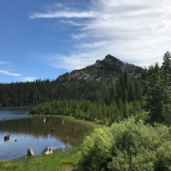
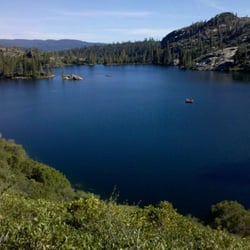
After being frustrated in the lack of access for our sedan to many of the lakes in the Lakes Basin, we looked forward to the easy access and hike to Madora Lake. The trailhead is marked by a sign on the Graeagle-Johnston Road (A-14), and is hard to miss if you are coming from Blairsden in the East. But if you are coming from the main part of the park, the sign faces the opposite way, and it's easy to miss (the trailhead sign is on the north side of the road, about 2 miles east of Park headquarters). There is a short, paved road to the trailhead, and we appreciated the lack of potholes after struggling through many of the forest service's access roads. No formal parking lot, but lots of room to park on the side of the road near the trailhead. A vault toilet is at the trailhead. The trail is 1.5 miles long, a loop around the lake. They are in the process of converting the trail to make it ADA accessible, and in the summer of 2017 parts of the trail could be closed depending upon construction. The whole trail was open when we were there in late August, parts of the trail now flattened and hardened, other parts still the original dusty dirt. Much of the trail goes through pine forest, a beautiful, peaceful setting. A small creek and an unexpected abundance of ferns can be found a small ways past the trailhead. However, if like us, you were expecting to see a beautiful mountain lake, this trail can be a bit of a disappointment. For most of the hike you can't see the lake at all, you are separated from it by the forest. But it turns out you aren't missing much: the lake is more like a large pond, and is rapidly being subsumed by an explosion of water-loving plants. A large number of willows along the lake edge shield the hiker from many lake views, and most views of the lake yield more plants than water. The best views of the lake are halfway through the trail along the north bank. A decent hike, and a good choice for those not prepared for anything strenuous - just maintain modest expectations for the "lake". read more


The Madora Lake Trail is a very accessible 1.5 mile loop that can be found just off the Graeagle-Johnsville Road (County Road A-14). Elevation is ~5,025 ft. Difficulty: Easy Hiking season: May to November, with wildflowers best in early to mid summer. read more


More info about Madora Lake Loop Trail
Graeagle-Johnsville Rd
County Rd A-14
Johnsville, CA 96103
Directions
Hours
Outdoor Amenities


Madora Lake Loop Trail - hiking - Updated July 2026
Best of Johnsville
People found Madora Lake Loop Trail by searching for…
Things to Do in Johnsville, California
Parks in Johnsville, California
Hiking Trails in Johnsville, California
Off Road Trails in Johnsville, California
Beautiful Views in Johnsville, California
Lakes & Ponds in Johnsville, California
Easy Hikes in Johnsville, California
Hiking Trails Kid Friendly in Johnsville, California
Swimming Holes in Johnsville, California
Waterfalls in Johnsville, California
Waterfall Hike in Johnsville, California
What to Do in Johnsville, California
Trails in Johnsville, California
Scenic Overlook in Johnsville, California
Parks for Kids in Johnsville, California
Running Trails in Johnsville, California
Hiking With Kids in Johnsville, California
Wildflowers in Johnsville, California
Redwood Forest in Johnsville, California
Places to Visit in Johnsville, California
To Do in Johnsville, California
Trending Searches in Johnsville, CA
Browse Articles
Browse Nearby
BEST of Johnsville, California Restaurants near Madora Lake Loop Trail
BEST of Johnsville, California Things to Do near Madora Lake Loop Trail
BEST of Johnsville, California Coffee near Madora Lake Loop Trail
BEST of Johnsville, California Swimming Holes near Madora Lake Loop Trail
BEST of Johnsville, California Ski Resorts near Madora Lake Loop Trail
BEST of Johnsville, California Breakfast near Madora Lake Loop Trail
BEST of Johnsville, California Campgrounds near Madora Lake Loop Trail
BEST of Johnsville, California Horseback Riding near Madora Lake Loop Trail
BEST of Johnsville, California Sledding near Madora Lake Loop Trail
Browse Brands
Related Searches in Johnsville, CA
Best Fishing Locations and Guides in Johnsville, California
Best Nature Trails for Hiking in Johnsville, California
Best Sledding Spots and Fun in Johnsville, California
Best Spots for Star Gazing in Johnsville, California
Best Waterfalls and Swimming Holes in Johnsville, California
Check Out Off Road Trails in Johnsville, California
Discover Dog Friendly Beaches Near Johnsville, California
Discover Popular Bike Trails in Johnsville, California
Discover Popular Photo Spots in Johnsville, California
Discover Scenic Mountain Bike Trails Near Johnsville, California
Discover Stunning Skyline View Spots in Johnsville, California
Discover Top Nature Parks to Visit in Johnsville, California
Discover a Hiking Trail in Johnsville, California
Discover the Best Running Track in Johnsville, California
Dog-Friendly Hikes With Dogs in Johnsville, California
Enjoy Scenic Night View Experiences in Johnsville, California
Enjoy Tent Camping Spots Around Johnsville, California
Enjoy a Beautiful Waterfall Hike in Johnsville, California
Enjoy the Best Night View Spots in Johnsville, California
Enjoy the Best Picnic Spots and Ideas in Johnsville, California
Enjoy the Best Walking Trails in Johnsville, California
Exciting Cliff Jumping Spots in Johnsville, California
Explore Beautiful Parks and Green Spaces in Johnsville, California
Explore Free Things to Do Around Johnsville, California
Explore Popular Campgrounds Near Johnsville, California
Explore Popular Scenic Overlook Points in Johnsville, California
Explore Scenic Lakes to Visit in Johnsville, California
Explore Secret Spots Worth Visiting in Johnsville, California
Explore Top Dog Parks in Johnsville, California Near You
Explore the Best Swimming Holes Around Johnsville, California
Explore the Best Trail Options in Johnsville, California
Family Friendly Hiking With Kids in Johnsville, California
Find Fun Kids Activities Outdoor in Johnsville, California
Find Parks and Recreation Activities in Johnsville, California
Find the Best Scenic View Locations in Johnsville, California
Hiking Trails With Waterfalls in Johnsville, California
Must-See Tourist Attractions Around Johnsville, California
Off Leash Dog Hiking Trails in Johnsville, California
Perfect Spots to Watch Sunset in Johnsville, California
Picnic Areas With BBQ Pits Available in Johnsville, California
Plan a Scenic Drive Route Near Johnsville, California
Popular Fishing Spots to Explore in Johnsville, California
Popular Picnic Spots to Visit in Johnsville, California
Popular Things to Do in Johnsville, California
Safe River Swimming Areas in Johnsville, California
Top Running Trails to Explore in Johnsville, California
Top Swimming Lakes to Enjoy in Johnsville, California
Top Swimming Spots and Pools in Johnsville, California
Top Things to Do With Teenagers in Johnsville, California
Uncover the Best Secluded Spots Around Johnsville, California
People who viewed Madora Lake Loop Trail also viewed
Frazier Falls Trail
28 reviews
Bear Lakes & Long Lake Loop Trail
14 reviews
Jamison Mine Trailhead
6 reviews
Upper Salmon Lake Trail to Deer Lake and Summit Lake
1 review
Sierra Buttes
17 reviews
Jamison Creek Lower Falls Trail
2 reviews
Grasshopper Flat Campground
12 reviews
Crystal Mine
2 reviews
Yuba Pass Sno-Park
1 review
Downieville Mountain Bike Trails
3 reviews