Sierra Discovery Trail Photos


You might also consider
More like Sierra Discovery Trail
Recommended Reviews - Sierra Discovery Trail
Start your review...

Reviews With Photos

Let me get this straight. I am not a hiker. For some reason, the need to experience nature overtook me last night and I spent countless hours, trying to find a trail which is less than a mile and not too far from Sacramento. When I searched directions online, it said it would take me an hour and a half to get there. Wrong, from elk grove, it took me almost 2 hours. Mainly because I was driving at 40 miles per hour over some parts of the I-80 FREEWAY. But I managed to make it there. Let's discuss how to get there from Elk Grove, Take 99 North to I-80 Reno freeway. From there, it is 66 miles of driving on that freeway and then it is Highway 20 for about 4.5 miles. Then make a right on Bowman Lake Road. Then it is half a mile to the parking lot of Sierra Discovery Trail on your left. It is easy to get there. The signs are clear. It is not the most spectacular hike but it craved my desire to experience nature. I went on a Tuesday AM and except for a bunch of people hiking together in a group, there was no one else there. I hoped I would not meet my maker, being alone and surrounded by forest and trees. Another great thing about this trail, dogs are allowed on leashes. But since it is two hours away from home, I am not going to put my poor dogs through a 2 hour car ride. Definitely a place to check out for non hikers and beginners like me.
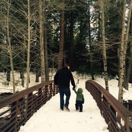
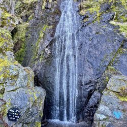
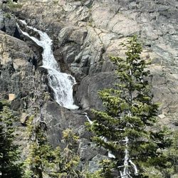
The Sierra Discovery Trail is a short (.9 mile) interpretive trail with a small waterfall that is managed by Pacific Gas and Electric (PG&E). This trail is located about 45 minutes from Roseville (take I-80, exit Hwy 20 and turn right, then turn right on Bowman Lake Road and the parking lot is about a half mile down the road on your left) and is fun year round. The entire trail is paved and during late spring through fall the trail is accessible by those who may have mobility difficulties; you will find snow during the winter months. This area is along the Bear River and there are two usually well maintained restrooms, picnic tables and BBQs. This trail and the surrounding area is definitely worth checking out before you continue your adventure down Bowman Lake Road.

3 years ago
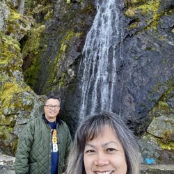
The trail if coming from I-80, take the turnoff for Hwy 20. Then the turnoff to the Sierra Discovery trail is off to the right approx 4.5 miles from I-80. Once at turnoff, follow the road for a bit, you will find a maintenance area and additional parking areas, then alittle farther down is the main parking lot. In the main parking lot there is a building with 2 clean vault toilets. There is a picnic area off to the right of the main parking lot. It took us about 45 mins to go along the entire trail, we made lots of stops along the trail. It's a fun and informative little walk the whole family can enjoy. We took our granddaughter who is 6 years old and she had fun she said on the trail. Her favorite sign along the trail was the information on the bobcat her favorite animal. We loved reading the informational signs along the way about the animals, plants and trees found in the area. While on your walk you can hear the rustling of the trees and the trickling water from the Bear river along the trail. There a few spots by the river to sit and just enjoy the sounds of nature all around you. Be sure to keep an eye out after passing the bridge for the small waterfall behind the bushes. Dogs are welcome on the trail and must be on a leash. Please be sure to clean up after your pet. Have a wonderful walk! read more


10 years ago
1 hour and 20 minutes drive from Midtown Sacramento Easy nature trail. I even came across a sign that pointed to the "Easier Way" and after taking the other route, I can only think it's easier because my route had slight inclines thus making that easier route easier because instead of going up, you'd be going downhill. Right? It's mostly a flat trail. There's a small waterfall but you don't have a great view from the trail. You would have to go a little ways off trail for a nice photo.. (if you choose to) but it's there. I like the informative signs throughout the trail pointing out what kind of tree you're looking at or interesting blurbs relating to it. There are two restrooms in the parking area. They're like permanent portapotties.. you know, the kind that has a permanent fixture but the toilet opens up to a hole in the ground. No sink, no soap. read more


10 years ago
Great trail any time of the year! Short walk through the woods near a creek. Good for almost all ages. read more


13 years ago
Let me get this straight. I am not a hiker. For some reason, the need to experience nature overtook me last night and I spent countless hours, trying to find a trail which is less than a mile and not too far from Sacramento. When I searched directions online, it said it would take me an hour and a half to get there. Wrong, from elk grove, it took me almost 2 hours. Mainly because I was driving at 40 miles per hour over some parts of the I-80 FREEWAY. But I managed to make it there. Let's discuss how to get there from Elk Grove, Take 99 North to I-80 Reno freeway. From there, it is 66 miles of driving on that freeway and then it is Highway 20 for about 4.5 miles. Then make a right on Bowman Lake Road. Then it is half a mile to the parking lot of Sierra Discovery Trail on your left. It is easy to get there. The signs are clear. It is not the most spectacular hike but it craved my desire to experience nature. I went on a Tuesday AM and except for a bunch of people hiking together in a group, there was no one else there. I hoped I would not meet my maker, being alone and surrounded by forest and trees. Another great thing about this trail, dogs are allowed on leashes. But since it is two hours away from home, I am not going to put my poor dogs through a 2 hour car ride. Definitely a place to check out for non hikers and beginners like me. read more


10 years ago
The Sierra Discovery Trail is a short (.9 mile) interpretive trail with a small waterfall that is managed by Pacific Gas and Electric (PG&E). This trail is located about 45 minutes from Roseville (take I-80, exit Hwy 20 and turn right, then turn right on Bowman Lake Road and the parking lot is about a half mile down the road on your left) and is fun year round. The entire trail is paved and during late spring through fall the trail is accessible by those who may have mobility difficulties; you will find snow during the winter months. This area is along the Bear River and there are two usually well maintained restrooms, picnic tables and BBQs. This trail and the surrounding area is definitely worth checking out before you continue your adventure down Bowman Lake Road. read more


11 years ago
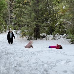
We took some out of town family on this trail in February. I'm guessing this trail is usually covered in snow this time of year, but this is a bad year for snowfall this year. We've hiked this trail twice in the past week since we only live 40 min away. Looking forward to exploring this area even more in the future. Nice picnic area near the parking lot. Cool waterfall at the end of the hike if you go to the right on the loop. Take your time a read some of the information boards on the hike. Took us about 30-40 min for the hike. read more


More info about Sierra Discovery Trail
Emigrant Gap, CA 95715
Directions
(916) 386-5164
Call Now
Visit Website
http://www.localhikesbeta.com/Hikes/Sierra-Discovery-Trail-1871
Hours
Indoor Amenities
Outdoor Amenities
Ask the Community - Sierra Discovery Trail
You might also consider


Sierra Discovery Trail - hiking - Updated July 2026
Best of Emigrant Gap
People found Sierra Discovery Trail by searching for…
Hiking Trails With Waterfalls in Emigrant Gap, California
Things to Do in Emigrant Gap, California
Off Road Trails in Emigrant Gap, California
Waterfalls and Swimming Holes in Emigrant Gap, California
Snow in Emigrant Gap, California
Natural Hot Springs in Emigrant Gap, California
Night Hike in Emigrant Gap, California
BBQ Picnic Area in Emigrant Gap, California
Dog Friendly Hiking Trails in Emigrant Gap, California
Easy Hiking Trails in Emigrant Gap, California
Scenic Overlook in Emigrant Gap, California
Waterfalls in Emigrant Gap, California
Photo Spots in Emigrant Gap, California
Visitor Centers in Emigrant Gap, California
Scenic View in Emigrant Gap, California
River Access in Emigrant Gap, California
Hiking With Kids in Emigrant Gap, California
Off Leash Dog Hikes in Emigrant Gap, California
Trail in Emigrant Gap, California
Stroller Walk in Emigrant Gap, California
Dog Friendly Things to Do in Emigrant Gap, California
Playground in Emigrant Gap, California
Browse Nearby
BEST of Emigrant Gap, California Parks near Sierra Discovery Trail
BEST of Emigrant Gap, California Restaurants near Sierra Discovery Trail
BEST of Emigrant Gap, California Scenic View near Sierra Discovery Trail
BEST of Emigrant Gap, California Things to Do near Sierra Discovery Trail
BEST of Emigrant Gap, California Coffee near Sierra Discovery Trail
BEST of Emigrant Gap, California Hot Springs near Sierra Discovery Trail
BEST of Emigrant Gap, California Breakfast near Sierra Discovery Trail
BEST of Emigrant Gap, California Campgrounds near Sierra Discovery Trail
BEST of Emigrant Gap, California Sledding near Sierra Discovery Trail
Browse Brands
Browse Articles
People who viewed Sierra Discovery Trail also viewed
Deer Creek Tribute Trail
14 reviews
Euchre Bar Trail
6 reviews
Cascade Canal Trail
3 reviews
Independence Lake Preserve
4 reviews
Thunder Mountain Hike
2 reviews
Lake Valley Reservoir
10 reviews
Oregon Creek Day Use Area
2 reviews
Webber Lake Campground
3 reviews
Donner Party Hike
1 review
Mount Lincoln Trail
1 review