Devil's hole Photos


More like Devil's hole
Recommended Reviews - Devil's hole
Start your review...

1 year ago


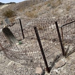
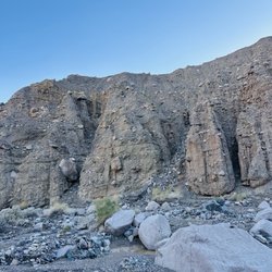
Dirt road all the way to the hole, I think its about 12miles... its drive able with sedan because I've seen it. I drove mazda cx5 and it was an okay ride to the hole. Its a really short walk to the first one and easy. The other one is rocky road and was bit difficult than it looks for normal people but it is do able. No fee to enter into ashmedow wildlife refuge, the parking seems to be only seasonal so we parked outside the gate. There are cameras everywhere to stop people from damaging or killing the devils hole pupfish. There are lot of drama with this place and why the fence and camera are in place the first place, its very sad. Other then it is stated that this hole may linked to gulf of Mexico, Ventura CA, as far as Spain. read more


3 years ago
More info about Devil's hole


Why does Yelp recommend reviews?
Devil's hole - landmarks - Updated July 2026
Best of Amargosa Valley
People found Devil's hole by searching for…
Things to Do in Amargosa Valley, Nevada
Parks in Amargosa Valley, Nevada
Fishing Spots in Amargosa Valley, Nevada
Abandoned Places in Amargosa Valley, Nevada
Scenic Views in Amargosa Valley, Nevada
Free Museum in Amargosa Valley, Nevada
Museums in Amargosa Valley, Nevada
Public Services & Government in Amargosa Valley, Nevada
Scenic Overlook in Amargosa Valley, Nevada
Sunday Fun Things to Do in Amargosa Valley, Nevada
Military Museum in Amargosa Valley, Nevada
Night View in Amargosa Valley, Nevada
Arts & Entertainment in Amargosa Valley, Nevada
Scenic Drive in Amargosa Valley, Nevada
Skyline View in Amargosa Valley, Nevada
Caves in Amargosa Valley, Nevada
Waterfalls in Amargosa Valley, Nevada
Courthouses in Amargosa Valley, Nevada
Tourist Attractions in Amargosa Valley, Nevada
Fun Stuff to Do in Amargosa Valley, Nevada
Churches in Amargosa Valley, Nevada
Make Out Spot in Amargosa Valley, Nevada