
Cove Outlook Park Photos


You might also consider
More like Cove Outlook Park
Recommended Reviews - Cove Outlook Park
Start your review...

10 years ago
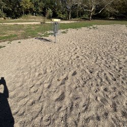
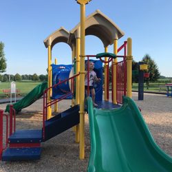
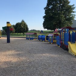
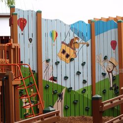
Cove Outlook Park (COP) is a beautiful park in Mount Joy. The town has a 25-year lease on the land since 2005 from Lancaster County Career & Technology Center and Public Works Department maintains it. I was excited when I found out about this place. Here's the amenities: * Trails * Volleyball Court * Horseshoe Pits * Playground * Pavilion with grills * Portable Toilets * Butterfly Garden * Bird Sanctuary * Multi-purpose Fields * Little Chiques Creek Unfortunately, what could be a peaceful oasis, turns out to be a bit stressful -especially for dogs- thanks to the Mount Joy Sportsmen Association, which is on Range Road adjacent to the park. I really can't bring my older dog to COP because he was spooked after our first visit and the noise of the shots got him scared. But I will definitely go back with my youngest son sometime. read more


9 years ago
Nice little hidden gem of a park in Mount Joy. It's good paved track with soccer fields in the middle. The fun is in walking through the trails itself. Bunch of little parks, bochie ball and volley ball. Love this place. read more


9 years ago
Cove Outlet Park in Mt. Joy is a nice family park for families. Playground facility as well as hiking trails through nice forested area. Well maintained and nature left to view without changing the landscape too much. Liked well-maintained trails and the stream that works its way through the park. Several short walking trails available in this compact city park. read more


10 years ago
More info about Cove Outlook Park
Old Market St
Mount Joy, PA 17552
Directions
(717) 367-0355
Call Now
Hours
Outdoor Amenities
You might also consider


Cove Outlook Park - hiking - Updated July 2026
Best of Mount Joy
People found Cove Outlook Park by searching for…
Public Running Track in Mount Joy, PA
Volleyball Courts in Mount Joy, PA
Places to Take Pictures in Mount Joy, PA
Beautiful Views in Mount Joy, PA
Soccer Fields in Mount Joy, PA
Bird Sanctuary in Mount Joy, PA
Parks for Kids in Mount Joy, PA
Walking Trails in Mount Joy, PA
Hiking Trails in Mount Joy, PA
Parks BBQ Grills in Mount Joy, PA
Secluded Spots in Mount Joy, PA
Kids Indoor Play Area in Mount Joy, PA
Swimming Holes in Mount Joy, PA
Fun Things to Do With Kids in Mount Joy, PA
Parks for Picnics in Mount Joy, PA
Trending Searches in Mount Joy, PA
Baby Activities near Cove Outlook Park
Baby First Birthday Party Venues near Cove Outlook Park
Baseball Fields near Cove Outlook Park
Blueberry Picking near Cove Outlook Park
Boardwalk near Cove Outlook Park
Boat Tours near Cove Outlook Park
Cliff Jumping near Cove Outlook Park
Cruising Spots near Cove Outlook Park
Day Trips near Cove Outlook Park
Dog Friendly Beaches near Cove Outlook Park
Dog Friendly Things To Do near Cove Outlook Park
Flower Fields near Cove Outlook Park
Free Picnic Areas near Cove Outlook Park
Free Things To Do With Kids near Cove Outlook Park
Indoor Dog Park near Cove Outlook Park
Indoor Playgrounds near Cove Outlook Park
Jet Ski Rental near Cove Outlook Park
Kayak Rental near Cove Outlook Park
Kids Activities Indoor near Cove Outlook Park
Kids Activities Outdoor near Cove Outlook Park
Off Road Trails near Cove Outlook Park
Outdoor Activities near Cove Outlook Park
Peach Picking near Cove Outlook Park
Picnic Spots near Cove Outlook Park
Places To Walk Around near Cove Outlook Park
Playgrounds near Cove Outlook Park
Public Shower near Cove Outlook Park
Rainy Day Activities near Cove Outlook Park
River Swimming near Cove Outlook Park
Rock Quarry near Cove Outlook Park
Scenic Night View near Cove Outlook Park
Scenic Overlook near Cove Outlook Park
Splash Pad near Cove Outlook Park
State Parks near Cove Outlook Park
Swimming Holes near Cove Outlook Park
Swimming Lakes near Cove Outlook Park
Things To Do On A Rainy Day near Cove Outlook Park
Things To Do With Kids near Cove Outlook Park
Watch Sunset near Cove Outlook Park
Browse Nearby
BEST of Mount Joy, Pennsylvania Restaurants near Cove Outlook Park
BEST of Mount Joy, Pennsylvania Coffee near Cove Outlook Park
BEST of Mount Joy, Pennsylvania Photo Spots near Cove Outlook Park
BEST of Mount Joy, Pennsylvania Things to Do near Cove Outlook Park
BEST of Mount Joy, Pennsylvania Parks near Cove Outlook Park
BEST of Mount Joy, Pennsylvania Breakfast near Cove Outlook Park
BEST of Mount Joy, Pennsylvania Campgrounds near Cove Outlook Park
BEST of Mount Joy, Pennsylvania Taxis near Cove Outlook Park
BEST of Mount Joy, Pennsylvania Ski Resorts near Cove Outlook Park
Browse Brands
Related Searches in Mount Joy, PA
Affordable Kayak Rental Services in Mount Joy, Pennsylvania
Best Dog Hiking Trails Around Mount Joy, Pennsylvania
Best Fishing Locations and Guides in Mount Joy, Pennsylvania
Best Kids Playgrounds to Visit in Mount Joy, Pennsylvania
Best Off Leash Dog Parks in Mount Joy, Pennsylvania
Best Parks for Parties and Events in Mount Joy, Pennsylvania
Best Places for Horseback Riding in Mount Joy, Pennsylvania
Best Sightseeing Experiences Available in Mount Joy, Pennsylvania
Best Water Parks for Kids in Mount Joy, Pennsylvania
Best Waterfalls and Swimming Holes in Mount Joy, Pennsylvania
Check Out Great Playgrounds in Mount Joy, Pennsylvania
Check Out Off Road Trails in Mount Joy, Pennsylvania
Discover Baseball Fields Around Mount Joy, Pennsylvania
Discover Beautiful Garden Spots in Mount Joy, Pennsylvania
Discover Dog Friendly Trails to Explore in Mount Joy, Pennsylvania
Discover Fun Activities to Do in Mount Joy, Pennsylvania
Discover Fun Kid Activities to Enjoy in Mount Joy, Pennsylvania
Discover Fun Toddler Parks in Mount Joy, Pennsylvania for Your Little One
Discover Kids Indoor Play Area Venues in Mount Joy, Pennsylvania
Discover Lakes & Ponds to Explore in Mount Joy, Pennsylvania
Discover Soccer Fields in Mount Joy, Pennsylvania Near You
Discover Top Nature Parks to Visit in Mount Joy, Pennsylvania
Discover Top State Parks to Visit in Mount Joy, Pennsylvania
Discover a Hiking Trail in Mount Joy, Pennsylvania
Discover the Best Beaches in Mount Joy, Pennsylvania
Discover the Best Fishing Lake in Mount Joy, Pennsylvania
Discover the Best Night Hike Trails in Mount Joy, Pennsylvania
Dog-Friendly Hikes With Dogs in Mount Joy, Pennsylvania
Enjoy Camping Adventures Around Mount Joy, Pennsylvania
Enjoy Hiking Adventures in Mount Joy, Pennsylvania
Enjoy Kayaking Adventures in Mount Joy, Pennsylvania
Enjoy Off Leash Dog Hikes in Mount Joy, Pennsylvania
Enjoy Scenic Places to Walk in Mount Joy, Pennsylvania
Enjoy Tent Camping Spots Around Mount Joy, Pennsylvania
Enjoy a Beautiful Waterfall Hike in Mount Joy, Pennsylvania
Enjoy the Best Family Activities in Mount Joy, Pennsylvania
Enjoy the Best Mini Golf Courses in Mount Joy, Pennsylvania
Enjoy the Best Picnic Spots and Ideas in Mount Joy, Pennsylvania
Enjoy the Best Walking Trails in Mount Joy, Pennsylvania
Explore Beautiful Parks and Green Spaces in Mount Joy, Pennsylvania
Explore Children's Museums Near Mount Joy, Pennsylvania
Explore Easy Hikes Perfect for All in Mount Joy, Pennsylvania
Explore Family-Friendly Zoos and Wildlife in Mount Joy, Pennsylvania
Explore Free Kids Activities Near Mount Joy, Pennsylvania
Explore Free Picnic Areas Around Mount Joy, Pennsylvania
Explore Fun Activities to Do in Mount Joy, Pennsylvania
Explore Outdoor Basketball Courts for All Skill Levels in Mount Joy, Pennsylvania