Corona de Loma Trail Photos


You might also consider
More like Corona de Loma Trail
Recommended Reviews - Corona de Loma Trail
Start your review...

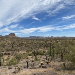
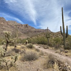
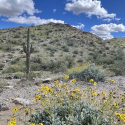
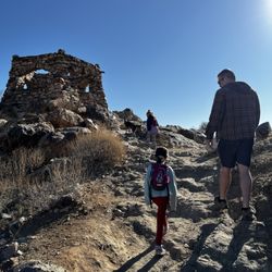
This hike is a 6.4-mile out-and-back trail in the hills of Phoenix's South Mountain Preserve. Corona de Loma is a challenging trail that is located just east of Eagle Pass and will take a few hours to complete. The beginning of the trail connects with the Thash Kavid Loop Trail or Warpaint Loop Trail. It is usually called the Warpaint Loop because it is off Warpaint Drive. I came here with a friend and we did the loop trail portion of the hike. The Warpaint Loop trail is around 2-miles and easy to hike because there is no elevation. It is a popular area for hiking, mountain biking and running. Because it is in a desert region, proper precautions should be taken while hiking it during the warmer seasons. Dogs must be on a leash. The Corona de Loma Trail takes you through a diverse terrain with a combination of flat sections. Parking is on the side of the road. read more
Great South Mountain trailhead, commonly called Warpaint trailhead due to entrance on Warpaint Dr in Awahtukee. There's a decent number of trails with varying degrees of difficulty for hikers and bikers. Most of the trails are fairly flat// little elevation change, so if you're a local and want to try hiking, this is a great start. Also good for visitors/tourists. Most popular trails are Desert Classic and Warpaint Loops. If you want climbing, try the Guadalupe Perimeter. Most of the trails can connect you to other trail systems in the park. Because of the fairly-flat nature of this trailhead system, it's great for star-gazing & observing sunrise/sunset. Fair warning though, some of the bigger desert critters (coyotes) will come out at night... I've heard them! The only downside of this trailhead are limited street parking and no bathrooms. Happy trails! read more

More info about Corona de Loma Trail


Corona de Loma Trail - mountainbiking - Updated July 2026
Best of Phoenix
People found Corona de Loma Trail by searching for…
Hiking Trails With Waterfalls in Phoenix, AZ
Places to Take Pictures in Phoenix, AZ
Easy Hiking Trails in Phoenix, AZ
Mountain Bike Trails in Phoenix, AZ
Things to Do With Teenagers in Phoenix, AZ
Abandoned Places in Phoenix, AZ
Off Road Trails in Phoenix, AZ
Scenic Overlook in Phoenix, AZ
Trending Searches in Phoenix, AZ
Beautiful Views near Corona de Loma Trail
Boating near Corona de Loma Trail
Cliff Jumping near Corona de Loma Trail
Cruising Spots near Corona de Loma Trail
Day Trips near Corona de Loma Trail
Dog Friendly Things To Do near Corona de Loma Trail
Dog Friendly Trails near Corona de Loma Trail
Dog Swimming near Corona de Loma Trail
Flower Fields near Corona de Loma Trail
Free Picnic Areas near Corona de Loma Trail
Jet Skis near Corona de Loma Trail
Kayak Rental near Corona de Loma Trail
Kids Activities Indoor near Corona de Loma Trail
Lakes near Corona de Loma Trail
Lookout Points near Corona de Loma Trail
Night Hike near Corona de Loma Trail
Off Road Trails near Corona de Loma Trail
Outdoor Activities near Corona de Loma Trail
Parks near Corona de Loma Trail
Peach Picking near Corona de Loma Trail
Picnic Spots near Corona de Loma Trail
River Swimming near Corona de Loma Trail
Rock Quarry near Corona de Loma Trail
Scenic Night View near Corona de Loma Trail
Scenic Overlook near Corona de Loma Trail
Sunrise View near Corona de Loma Trail
Surf Shop near Corona de Loma Trail
Swimming Holes near Corona de Loma Trail
Things To Do On A Rainy Day near Corona de Loma Trail
U Pick Farms near Corona de Loma Trail
Watch Sunset near Corona de Loma Trail
Water Parks near Corona de Loma Trail
Browse Articles
Browse Nearby
BEST of Phoenix, Arizona Coffee near Corona de Loma Trail
BEST of Phoenix, Arizona Restaurants near Corona de Loma Trail
BEST of Phoenix, Arizona Things to Do near Corona de Loma Trail
BEST of Phoenix, Arizona Breakfast near Corona de Loma Trail
BEST of Phoenix, Arizona Hiking Trails near Corona de Loma Trail
BEST of Phoenix, Arizona Parks near Corona de Loma Trail
BEST of Phoenix, Arizona Campgrounds near Corona de Loma Trail
Browse Brands
Related Searches in Phoenix, AZ
Affordable Bike Repair Services in Phoenix, Arizona
Affordable Cheap Bike Tune Up Services in Phoenix, Arizona
Affordable Kayak Rental Services in Phoenix, Arizona
Affordable Road Bike Rental in Phoenix, Arizona
Best Dirt Bike Riding Spots in Phoenix, Arizona
Best Dog Hiking Trails Around Phoenix, Arizona
Best Electric Bike Rental Services in Phoenix, Arizona
Best Fishing Locations and Guides in Phoenix, Arizona
Best Nature Trails for Hiking in Phoenix, Arizona
Best Places for Horseback Riding in Phoenix, Arizona
Best Sightseeing Experiences Available in Phoenix, Arizona
Check Out Off Road Trails in Phoenix, Arizona
Convenient Bike Sharing Programs in Phoenix, Arizona
Discover Dog Friendly Trails to Explore in Phoenix, Arizona
Discover Easy Hiking Trails Near Phoenix, Arizona
Discover Kid Friendly Hiking Trails in Phoenix, Arizona
Discover Popular Bike Tours in Phoenix, Arizona
Discover Popular Bike Trails in Phoenix, Arizona
Discover Scenic Bike Paths in Phoenix, Arizona
Discover Scenic Mountain Bike Trails Near Phoenix, Arizona
Discover Walking Parks in Phoenix, Arizona Near You
Discover a Hiking Trail in Phoenix, Arizona
Discover the Best Night Hike Trails in Phoenix, Arizona
Dog-Friendly Hikes With Dogs in Phoenix, Arizona
Enjoy Camping Adventures Around Phoenix, Arizona
Enjoy Hiking Adventures in Phoenix, Arizona
Enjoy Kayaking Adventures in Phoenix, Arizona
Enjoy Off Leash Dog Hikes in Phoenix, Arizona
Enjoy Scenic Dirt Bike Trails Around Phoenix, Arizona
Enjoy Scenic Places to Walk in Phoenix, Arizona
Enjoy Tent Camping Spots Around Phoenix, Arizona
Enjoy a Beautiful Waterfall Hike in Phoenix, Arizona
Enjoy the Best Tubing Experiences in Phoenix, Arizona
Enjoy the Best Walking Path in Phoenix, Arizona
Enjoy the Best Walking Trails in Phoenix, Arizona
Explore BMX Bike Shops Near Phoenix, Arizona
Explore Beautiful Parks and Green Spaces in Phoenix, Arizona
Explore Bike Rentals Throughout Phoenix, Arizona
Explore Easy Hikes Perfect for All in Phoenix, Arizona
Explore Electric Bikes Available in Phoenix, Arizona
Explore Fun Activities to Do in Phoenix, Arizona
Explore Mountain Bike Rentals Available in Phoenix, Arizona
Explore Popular Campgrounds Near Phoenix, Arizona
Explore Popular Scenic Overlook Points in Phoenix, Arizona
Explore Popular Scenic Views Near Phoenix, Arizona
Explore Top Dog Parks in Phoenix, Arizona Near You