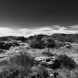
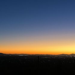
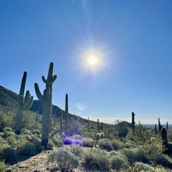
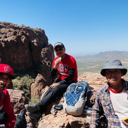
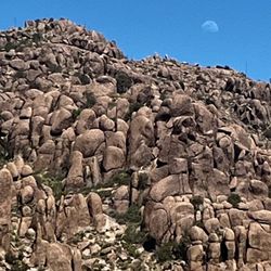
Pass Mountain Loop Trail Photos


You might also consider
More like Pass Mountain Loop Trail
Recommended Reviews - Pass Mountain Loop Trail
Start your review...

I came here on a Saturday morning to run, and I arrived at the parking lot at 10:15AM. Note that since this is inside Usery Mountain Regional Park, there's a $7 per motor vehicle. The parking lot was entirely full and street parking was pretty full too, but luckily I snagged a spot right at the trailhead as a car left. I went clockwise on the trail, and the map at the beginning says this trail is 7.5 miles (but actually if I add up the mileage on the map, it's 7.6 miles). The views before going down were good but once I went to the back of the mountain, the views weren't very good. Completely unshaded, most people are going counterclockwise so I ran into a lot of hikers, a few bikes, and even a horseback rider and his horse. Some parts of the path are a bit rockier than the others, but all manageable for running. read more


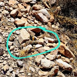
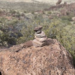
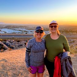
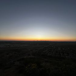
I spend much of my time on this trail running, especially if I want something that provides a lot of varied terrain and isn't too crowded. Wind Cave is an awesome workout, but it is typically a lot more crowded. A good portion of the trail is runnable, which is nice. For a moderate running pace, two hours should be fine. In talking to people on the trail, it seems that hikers typically plan 3.5-4 hours to do the whole thing. Maybe longer if you stop at the saddle to have a snack and enjoy the views for a bit. Speaking of that, there are several places to stop and enjoy the views, especially on the backside of the mountain, and it is really beautiful when the desert blooms. I was out here a few years ago when we got snow on January 1, and that was pretty cool to see. These days, I mostly see hikers, although there are some adventurous mountain bikers -- there is an interesting climb (or descent, depending on your chosen direction) just before/after the saddle. I've seen people carrying their bikes on that one. I think tackling this trail clockwise on a bike might be best, although I typically run it counterclockwise to get the rougher parts of the trail out of the way first. The trail is pretty rocky in spots between Blevins and the saddle. It is good to note that you can jump on this trail either from the Wind Cave or Blevins (Trailhead Staging Area) parking areas, but the marked trailhead is at the Blevins parking lot. There is nowhere to get water, except at the Wind Cave trailhead, which, depending on where you park, could be your start/end point. It is best to bring all that you'll need, especially in the summer. This is a loop trail, but there are really no shortcuts out of the trail, so you either plan to do the whole thing or pick a spot to turn around when you're halfway done with hiking. (The trail does connect to the Cat Peaks trail about a mile from the Blevins trailhead, and forks off to connect with the Arizona Trail, but once you're really into the trail, there are much fewer options.) As for shade, the only real shade is provided during certain parts of the year and times of day at the saddle. There are some trees and, if you can crouch in the shadow of some rock formations, you can find a little. Beyond that, it is pretty sparse. I suggest starting early in the morning. Keep an eye out for wildlife. I have scared several deer and jackrabbits in addition to the usual lizards, squirrels and occasional rattlesnake. There is a $6 fee to enter the park by car ($2 if you bike, walk, or run in) and the Maricopa County Parks pass is good here. read more


11 years ago
This is a rich, desert, mountainous hiking loop trail. Want to learn more about rattlesnakes, cacti, strange saguaros, geology, wild flowers, lizards, gray fox, desert tortoise, birds of prey and looking for something to do today? Maybe a full moon walk to listen to the bats sing, owls call and the coyotes howl? The trail offers photographers, endurance training or hikers superb opportunity to take in the beauty of the earth from this steep and sweet 2,840-foot elevation. Round trip 7.4 miles, 3 to 5 hours. Elevation gain, a thousand feet.This is some great outdoors. There are three access points for this trail. One is from the horse staging/ picinic area at the east end of the park. 3939 North Usery Pass Road, Mesa, AZ 8520, This is the actual trailhead. The second is from the Wind Cave Trailhead. http://www.yelp.com/biz/wind-cave-trail-mesa?osq=Wind+Cave+Trailhead The third is not inside the park but rather on National Forest land at the Northern terminus of Meridian Road. 5635 N Meridian Rd. Apache Junction, Arizona read more


10 years ago
More info about Pass Mountain Loop Trail
5635 N Meridian Rd
Apache Junction, AZ 85120
Directions
(480) 984-0032
Call Now
Hours
Outdoor Amenities
Ask the Community - Pass Mountain Loop Trail
You might also consider


Pass Mountain Loop Trail - hiking - Updated June 2026
Best of Apache Junction
People found Pass Mountain Loop Trail by searching for…
Watch Sunset in Apache Junction, AZ
Night Hike in Apache Junction, AZ
Hiking Trails in Apache Junction, AZ
Off Road Trails in Apache Junction, AZ
Easy Hikes in Apache Junction, AZ
Scenic View in Apache Junction, AZ
Mountain Biking in Apache Junction, AZ
Things to Do With Kids in Apache Junction, AZ
Stroller Friendly Hikes in Apache Junction, AZ
Sunset View in Apache Junction, AZ
Waterfall Hike in Apache Junction, AZ
Places to Run in Apache Junction, AZ
Places to Walk at Night in Apache Junction, AZ
Walking Trails in Apache Junction, AZ
National Parks in Apache Junction, AZ
Scenic Overlook in Apache Junction, AZ
Fun Things to Do in Apache Junction, AZ
Hiking With Kids in Apache Junction, AZ
Trending Searches in Apache Junction, AZ
Amusement Parks near Pass Mountain Loop Trail
Beaches near Pass Mountain Loop Trail
Black Owned Nail Salons near Pass Mountain Loop Trail
Boat Rental near Pass Mountain Loop Trail
Cliff Jumping near Pass Mountain Loop Trail
Creeks near Pass Mountain Loop Trail
Fishing Spots near Pass Mountain Loop Trail
Free Kids Activities near Pass Mountain Loop Trail
Jet Ski Rental near Pass Mountain Loop Trail
Lakes near Pass Mountain Loop Trail
Outdoor Activities near Pass Mountain Loop Trail
Pick Your Own Farms near Pass Mountain Loop Trail
Picnic Parks near Pass Mountain Loop Trail
Public Shower near Pass Mountain Loop Trail
Rock Quarry near Pass Mountain Loop Trail
Running Trails near Pass Mountain Loop Trail
Scenic Drive near Pass Mountain Loop Trail
Secluded Spots near Pass Mountain Loop Trail
Soccer Store near Pass Mountain Loop Trail
Splash Pad near Pass Mountain Loop Trail
Strawberry Picking near Pass Mountain Loop Trail
Sunrise View near Pass Mountain Loop Trail
Swimming Holes near Pass Mountain Loop Trail
Swimming Lakes near Pass Mountain Loop Trail
Swimming Pools near Pass Mountain Loop Trail
Watch Sunset near Pass Mountain Loop Trail
Browse Articles
Browse Nearby
BEST of Apache Junction, Arizona Restaurants near Pass Mountain Loop Trail
BEST of Apache Junction, Arizona Coffee near Pass Mountain Loop Trail
BEST of Apache Junction, Arizona Things to Do near Pass Mountain Loop Trail
BEST of Apache Junction, Arizona Breakfast near Pass Mountain Loop Trail
BEST of Apache Junction, Arizona Shopping near Pass Mountain Loop Trail
Browse Brands
Related Searches in Apache Junction, AZ
Affordable Kayak Rental Services in Apache Junction, Arizona
Best Fishing Locations and Guides in Apache Junction, Arizona
Best Places for Horseback Riding in Apache Junction, Arizona
Best Waterfalls and Swimming Holes in Apache Junction, Arizona
Check Out Off Road Trails in Apache Junction, Arizona
Discover Dog Friendly Trails to Explore in Apache Junction, Arizona
Discover Scenic Mountain Bike Trails Near Apache Junction, Arizona
Discover Walking Parks in Apache Junction, Arizona Near You
Discover a Hiking Trail in Apache Junction, Arizona
Discover the Best Night Hike Trails in Apache Junction, Arizona
Discover the Best Running Track in Apache Junction, Arizona
Enjoy Camping Adventures Around Apache Junction, Arizona
Enjoy Exciting Mountain Biking Adventures in Apache Junction, Arizona
Enjoy Kayaking Adventures in Apache Junction, Arizona
Enjoy River Tubing Adventures in Apache Junction, Arizona
Enjoy Tent Camping Spots Around Apache Junction, Arizona
Enjoy a Beautiful Waterfall Hike in Apache Junction, Arizona
Enjoy the Best Tubing Experiences in Apache Junction, Arizona
Enjoy the Best Walking Path in Apache Junction, Arizona
Enjoy the Best Walking Trails in Apache Junction, Arizona
Experience Thrilling White Water Rafting in Apache Junction, Arizona
Explore Beautiful Parks and Green Spaces in Apache Junction, Arizona
Explore Easy Hikes Perfect for All in Apache Junction, Arizona
Explore Fun Activities to Do in Apache Junction, Arizona
Explore Popular Campgrounds Near Apache Junction, Arizona
Explore Top Dog Parks in Apache Junction, Arizona Near You
Explore the Best Beach Spots in Apache Junction, Arizona
Explore the Best Boating Spots in Apache Junction, Arizona
Explore the Best Trail Options in Apache Junction, Arizona
Family Friendly Hiking With Kids in Apache Junction, Arizona
Find Beautiful Views in Apache Junction, Arizona
Find Popular Ziplining Spots Around Apache Junction, Arizona
Find the Best Parks for Picnics in Apache Junction, Arizona
Find the Best Scenic View Locations in Apache Junction, Arizona
Great Places to Walk in Apache Junction, Arizona
Hiking Trails With Waterfalls in Apache Junction, Arizona
Off Leash Dog Hiking Trails in Apache Junction, Arizona
Plan a Scenic Drive Route Near Apache Junction, Arizona
Popular Fishing Spots to Explore in Apache Junction, Arizona
Popular Outdoor Activities to Try in Apache Junction, Arizona
Popular Picnic Spots to Visit in Apache Junction, Arizona
Safe River Swimming Areas in Apache Junction, Arizona
Safe and Fun Parks for Kids in Apache Junction, Arizona
Top Climbing Spots and Gyms in Apache Junction, Arizona
Top Places for Snorkeling in Apache Junction, Arizona
Top Running Trails to Explore in Apache Junction, Arizona
Top Swimming Lakes to Enjoy in Apache Junction, Arizona
Top Swimming Spots and Pools in Apache Junction, Arizona
Walk Dog Friendly Hiking Trails in Apache Junction, Arizona
Walk the Best Paved Walking Trails in Apache Junction, Arizona