Peralta Trails Photos


You might also consider
More like Peralta Trails
Recommended Reviews - Peralta Trails
Start your review...

Reviews With Photos

I had been wanting to check out the Peralta Trail since moving back to the Valley two years ago, but didn't want to risk driving my older Civic on that dirt road to get to the trailhead. The photos all over social media did not quell this longstanding desire. One of my friends invited my wife and I to join him one morning in his pickup and we couldn't refuse! We arrived at the trailhead by 6:30 am and proceeded along the Peralta Trail to Fremont Saddle. The the long and winding journey up the mountain takes you through heavy brush as well as some pretty phenomenal rock formations. Wildlife runs aplenty here -- I even saw a cardinal hunting for food between the bushes! Fremont Saddle, when you finally reach it, is a sight to behold, with Weaver's Needle in the distance and the eastern range of the Supes in seemingly panoramic view. After stopping to admire this beautiful scenery, we continued on to the lone pinyon pine and marveled as to how it came to grow there with no other such pines in sight! It truly is something remarkable to see first-hand. A few last words of advice: *Start early and bring plenty of water, especially in the summer when the weather heats up. Parking is limited. *While I've seen plenty of sedans at the parking area, I still wouldn't take my '03 Civic on that dirt road. Know your car and go prepared for the unpaved road. *Pack in what you pack out aka DO NOT LITTER! *Enjoy the outdoors!

Great Reprieve From The City! After a rain this is one excellent place to get out of the city and TAKE A HIKE! The rain brings out the green and the happy scents in this area with more green already in place than most desert areas. You wind your way through valleys and up and down mountains until you reach whatever destination you are heading for that particular day in an array of wildlife and peace and quiet. This last trip we hiked to Fremont Needle which is the monolithic rock that looks like a thumb to me... There are several caves in this area and some mines to explore also if you are so inclined! Weekdays are my favorite hiking days since there are not so many people on the trails. Don't forget lots of water since there isn't much to be found if you run out. All in all a great spot! Now... GO TAKE A HIKE!

We were looking to do a nice scenic hike on a Sunday. We heard that Peralta Trails had jaw dropping phenomenal scenic views within the Superstition mountains. To get to the head of the trail, there was about 8 miles of unpaved semi-rocky roads. I drove a sedan, but wished I had taken my SUV instead. Nevertheless we did make it. We read that the trail was considered moderate and about 5 miles roundtrip. The terrain started off pretty easy and then gradually became rock steps in certain areas. There was a plethora of great photo-ops along the trail. We unfortunately got caught in the rain and we were in the middle of a torrential downpour getting super soaked not even half-way to our summit. The rainwater made the hike more treacherous and what used to be pathways became mini rivers and waterfalls. We didn't want to give up because we had come so far already. The rain did let up for 20 minutes where we scooted quickly and found a cave as a shelter. That was when the hardest rain came pouring down, but we were safe. It certainly felt like an episode of Naked and Afraid, desert edition and clothed. We were shivering in the cave when a passerby saw us and told us that we were only 5 minutes from the peak. At this point, we had been hiking for about 2 hours. We persevered and made it to Weaver's needle where we had the most astounding view. Suddenly the rain stopped completely. The trek to the peak was definitely not an easy feat, but the view was well worth it. Going down was a lot easier and we made it down in just a little over an hour. The cave saved the day for us and I would love to come back on a sunnier day! :)

Maybe it's because I'm new to AZ and this was my first hike in the "desert" but I was blown away by the views here. We took Peralta Trail to Fremont Saddle and would ranks this as moderate. While not a difficult or dangerous hike, you will get some cardio in as you go up and a few spots require climbing around some boulders, nothing crazy though. There was a wide range of skill and fitness level on the trail. We went out early afternoon on a weekend and it was not too crowded. We took 2 dogs and they loved it and made tons of friends. Be sure to use the restroom before you go and bring lots of water! There is nothing at the trail head. Also, it is a gravel road leading out to the trail, most cards should not have an issue making it out there but good to be aware of. Enjoy the hike and the views!

This trail is a very popular with what my buddy calls "Lululemon hikers"...college girls in their yoga pants out on day hikes...which is cool with me. However on this day there was over 16" of snow at the top of Peralta Trail and the trail was either frozen hardback snow/ice (causing tons of people to slip/slide and fall) or the lower part of the trail was literally flowing water....both situations are quite rare in the Arizona dessert. The views are great, its a beautiful trail...simple 6 miles round trip to the saddle (shown in the photo.) to view Weavers Needle.

This is one of my favorite hikes in the Phoenix valley. Pretty easy to find. Just take US 60E past Gold Canyon to Peralta Road and follow it all the way to the last parking lot at the end of the road. There is about 7 miles of washboard gravel road which can definitely be done with a car, but just be careful in a few spots so you don't bottom out. The hike is about 5 miles round trip if you just go the the saddle with the great view of Weaver's Needle. It took me about 2.5 hours with a few breaks. Not too difficult with the first part of the hike having some shaded areas which is nice when it's hot out. You get great views of the superstition mountains all around, and if you go after a recent rain, there will be water flowing in the stream that you cross a few times (there are rocks to cross on so your feet don't get wet)

This was a beautiful hike! Different than lots of other around the valley. Lots of plants and bushes at the bottom so the scenery is a nice change from just dirt and rocks. The drive was about 1 hour from South Scottsdale. Very easy to get to - take the 60 all the way to Peralta Road, turn left onto Peralta and it takes you directly to parking areas. ***Peralta Road turns into a dirt washboard road that you drive along for about 8 miles! It took us about 3 hours total. We did spend a decent amount of the time at the top climbing though! There is a bathroom at the beginning of the trailhead but no running water.

Wow wow wow. There a few trails here, the one we took is a bit less traveled. You have to pass through a small barbed wire walkway in the wilderness line fence, but then you start ascending the mountain and end up at the most beautiful cave - "The Wave Cave". On a beautiful spring weekend, there were still only about u other people we saw during our hike. And once we made it to the cave we had it all to ourselves! It was amazing. Great hike, even greater views. Just lookout for snakes and grazing steer!

Peralta Trail starts at the Trailhead off Peralta Road. Beware the asphalt ends after about a mile turning off of the US 60. It's somewhat maintained but will rattle your teeth for the next 7-8 miles. There are 2 trailheads before you reach Peralta Trailhead. Carney and Lost Goldmine TH. If you aren't sure where you are, keep driving as Peralta TH is as far as you can drive. Once you reach Trailhead you have option to use 2 gender neutral bathrooms. They aren't always pretty but serves its purpose. From the start you have 3 different options of Trails you can take. Peralta Trail, Bluff Spring Trail and Dutchmans Trail. So please read info board and get your bearings. The Peralta Trail as you face Trailhead from parking lot will be your farthest left option. Peralta Trail like all the trails in Superstition is great. It is somewhat crowded depending on time of day and year. It's dog friendly but please bring a leash. I go early to let dogs go unleashed and not bother other hikers. Once suns up, you will pass others so please be mindful of that. Some dogs are friendly, some not so much. Some people are dog friendly, some not so much. As with hiking on any trail bring water. There is not water fountains which our last time out some other "hikers" were mad about. (This blows my mind. Hiking in Arizona and people want water fountains). This trail heads north, northwest and about 6 miles you reach Upper Black Top Mesa Pass. You can continue on which will be for a different trail review, turnaround and go back same path or do a loop and head back to Trailhead via Bluff Spring Trail. If you choose to do the loop, take Dutchmans Trail to the east until you reach Terrapin Trail and go south. Take Terrapin Trail until Bluff Spring Trail. Bluff Spring will take you back to Peralta Trailhead. If you do your research you will see things most people never do. But please be respectful of the things you see or find and leave things as you find them. 1. Don't ever underestimate the desert. Plan your trip, tell someone where you are going and look at weather report. 2. Water, water, water. It seems like I'm always having to give someone water as I come across some poor souls who had no business hiking. 3. Hat, sunscreen, proper shoes/boots. 4. Be realistic of your physical limits. 5. Pack out what you pack in. It drives me nuts why people throw their bottles and wrappers on ground. Yes, I'm one of those people who pick your crap up. Honestly I love the Superstition Wilderness area and at this point have hiked the majority of trails in the region. People should read up on the history of these mountains and you will be intrigued with the history from the original inhabitants, early settlers and of course the gold folklore. Put your smart phones down and read up on. Put down your video game controllers and grab your backpack and go be adventurous. Peralta Trail is just one Trail of so many in this region that offers magnificent views, natural wonders, caves and some other surprising things if you are the Indiana Jones type. That you will have to find out for yourself as I also keep my secret findings to myself. I have learned to be able to preserve something unique, don't publicize it.

Wonderful hike for out of town guests. Not a regular hike for me due to distance but a friend asked me to sweep for out of town guests. Due to the rain the landscape was green and lush. It is best to use a vehicle that you don't care about because the trail starts five miles down a dirt road. The Rocky trail is worth the beautiful desert vistas. Elevation is 1500 so it is a good idea to be somewhat on shape.


7 Miles down a washboard gravel road just outside of Gold Canyon AZ, lies a trailhead known as the Peralta Trail. People come here in droves to hike this trail This hike has it all. There are steep challenging parts and mostly flat, catch your breath parts. About a 5 mile round trip, this hike is filled with beautiful desert landscape and rugged mountain views. The climax is at the top, well known as "The Saddle". Here you get a prime view of Weaver's Needle. Legend has it, The Lost Dutchman mine is within eye shot of this peak. Any way the view alone is worth the trek. We hike it several times a year. Here are some tips. We have hiked this trail early in the morning. The pro is that it's cool when you start out. The con is that you are in the sun the whole hike, and by the end it gets pretty toasty on a late spring day. We have hiked it late in the afternoon. That time of day is the hottest part of the day. You spend the first half of the hike on a steep incline in the sun. The benefit of doing this is that the second half of the hike is nearly all shaded as the south ridge blocks the afternoon sun. Even sweeter is on the return trip, It's down hill and the whole trail is shaded by the late in the afternoon. This is a popular hike, so you will have to share the trail with many other hikers. This is one of my favorite hikes. There will be as many return trips as this old body can do.

This is a great trail. It's a nice hike but doable for dogs that are learning to hike (like mine)! Honestly this is probably my favorite hike I've done in the Superstitions. Perfect distance with a great reward view of weavers needle. We even saw a spot where you can camp at the top. Pack a lunch and head here with your four-legged friend!!!!

7 days ago
Absolutely amazing views! In 5 miles. 1440 fr elevation so not hard, you can be in a middle of nowhere, with amazing nature and the pictures just don't do justice how beautiful this area is. read more


This is a delightful escape from the city. The hike itself is actually fairly easy. The views are so beautiful that you forget you are hiking until you feel it on the way back to the parking lot (depending on how far you hike). Pretty much anyone can do this hike. We saw a bunch of toddlers on the trail, as well as several groups of seniors. You can a view of the large boulders, various cacti, and other plant and animal life. The weaver's needle is very majestic looking. I think my only complaint is that you are traveling on a gravel road for quite a while. There were a few aggressive truck drivers driving incredibly fast to pass people, but also some smaller cars driving at slower speeds. It takes about 1.5 hours to get to weaver's needle so not too strenuous of a hike at all. read more


I had been wanting to check out the Peralta Trail since moving back to the Valley two years ago, but didn't want to risk driving my older Civic on that dirt road to get to the trailhead. The photos all over social media did not quell this longstanding desire. One of my friends invited my wife and I to join him one morning in his pickup and we couldn't refuse! We arrived at the trailhead by 6:30 am and proceeded along the Peralta Trail to Fremont Saddle. The the long and winding journey up the mountain takes you through heavy brush as well as some pretty phenomenal rock formations. Wildlife runs aplenty here -- I even saw a cardinal hunting for food between the bushes! Fremont Saddle, when you finally reach it, is a sight to behold, with Weaver's Needle in the distance and the eastern range of the Supes in seemingly panoramic view. After stopping to admire this beautiful scenery, we continued on to the lone pinyon pine and marveled as to how it came to grow there with no other such pines in sight! It truly is something remarkable to see first-hand. A few last words of advice: *Start early and bring plenty of water, especially in the summer when the weather heats up. Parking is limited. *While I've seen plenty of sedans at the parking area, I still wouldn't take my '03 Civic on that dirt road. Know your car and go prepared for the unpaved road. *Pack in what you pack out aka DO NOT LITTER! *Enjoy the outdoors! read more


7 years ago
Great Reprieve From The City! After a rain this is one excellent place to get out of the city and TAKE A HIKE! The rain brings out the green and the happy scents in this area with more green already in place than most desert areas. You wind your way through valleys and up and down mountains until you reach whatever destination you are heading for that particular day in an array of wildlife and peace and quiet. This last trip we hiked to Fremont Needle which is the monolithic rock that looks like a thumb to me... There are several caves in this area and some mines to explore also if you are so inclined! Weekdays are my favorite hiking days since there are not so many people on the trails. Don't forget lots of water since there isn't much to be found if you run out. All in all a great spot! Now... GO TAKE A HIKE! read more


We were looking to do a nice scenic hike on a Sunday. We heard that Peralta Trails had jaw dropping phenomenal scenic views within the Superstition mountains. To get to the head of the trail, there was about 8 miles of unpaved semi-rocky roads. I drove a sedan, but wished I had taken my SUV instead. Nevertheless we did make it. We read that the trail was considered moderate and about 5 miles roundtrip. The terrain started off pretty easy and then gradually became rock steps in certain areas. There was a plethora of great photo-ops along the trail. We unfortunately got caught in the rain and we were in the middle of a torrential downpour getting super soaked not even half-way to our summit. The rainwater made the hike more treacherous and what used to be pathways became mini rivers and waterfalls. We didn't want to give up because we had come so far already. The rain did let up for 20 minutes where we scooted quickly and found a cave as a shelter. That was when the hardest rain came pouring down, but we were safe. It certainly felt like an episode of Naked and Afraid, desert edition and clothed. We were shivering in the cave when a passerby saw us and told us that we were only 5 minutes from the peak. At this point, we had been hiking for about 2 hours. We persevered and made it to Weaver's needle where we had the most astounding view. Suddenly the rain stopped completely. The trek to the peak was definitely not an easy feat, but the view was well worth it. Going down was a lot easier and we made it down in just a little over an hour. The cave saved the day for us and I would love to come back on a sunnier day! :) read more

7 years ago
Maybe it's because I'm new to AZ and this was my first hike in the "desert" but I was blown away by the views here. We took Peralta Trail to Fremont Saddle and would ranks this as moderate. While not a difficult or dangerous hike, you will get some cardio in as you go up and a few spots require climbing around some boulders, nothing crazy though. There was a wide range of skill and fitness level on the trail. We went out early afternoon on a weekend and it was not too crowded. We took 2 dogs and they loved it and made tons of friends. Be sure to use the restroom before you go and bring lots of water! There is nothing at the trail head. Also, it is a gravel road leading out to the trail, most cards should not have an issue making it out there but good to be aware of. Enjoy the hike and the views! read more


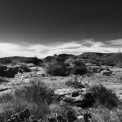
This trail is a very popular with what my buddy calls "Lululemon hikers"...college girls in their yoga pants out on day hikes...which is cool with me. However on this day there was over 16" of snow at the top of Peralta Trail and the trail was either frozen hardback snow/ice (causing tons of people to slip/slide and fall) or the lower part of the trail was literally flowing water....both situations are quite rare in the Arizona dessert. The views are great, its a beautiful trail...simple 6 miles round trip to the saddle (shown in the photo.) to view Weavers Needle. read more

10 years ago
This is one of my favorite hikes in the Phoenix valley. Pretty easy to find. Just take US 60E past Gold Canyon to Peralta Road and follow it all the way to the last parking lot at the end of the road. There is about 7 miles of washboard gravel road which can definitely be done with a car, but just be careful in a few spots so you don't bottom out. The hike is about 5 miles round trip if you just go the the saddle with the great view of Weaver's Needle. It took me about 2.5 hours with a few breaks. Not too difficult with the first part of the hike having some shaded areas which is nice when it's hot out. You get great views of the superstition mountains all around, and if you go after a recent rain, there will be water flowing in the stream that you cross a few times (there are rocks to cross on so your feet don't get wet) read more


This was a beautiful hike! Different than lots of other around the valley. Lots of plants and bushes at the bottom so the scenery is a nice change from just dirt and rocks. The drive was about 1 hour from South Scottsdale. Very easy to get to - take the 60 all the way to Peralta Road, turn left onto Peralta and it takes you directly to parking areas. ***Peralta Road turns into a dirt washboard road that you drive along for about 8 miles! It took us about 3 hours total. We did spend a decent amount of the time at the top climbing though! There is a bathroom at the beginning of the trailhead but no running water. read more


10 years ago
Wow wow wow. There a few trails here, the one we took is a bit less traveled. You have to pass through a small barbed wire walkway in the wilderness line fence, but then you start ascending the mountain and end up at the most beautiful cave - "The Wave Cave". On a beautiful spring weekend, there were still only about u other people we saw during our hike. And once we made it to the cave we had it all to ourselves! It was amazing. Great hike, even greater views. Just lookout for snakes and grazing steer! read more


Peralta Trail starts at the Trailhead off Peralta Road. Beware the asphalt ends after about a mile turning off of the US 60. It's somewhat maintained but will rattle your teeth for the next 7-8 miles. There are 2 trailheads before you reach Peralta Trailhead. Carney and Lost Goldmine TH. If you aren't sure where you are, keep driving as Peralta TH is as far as you can drive. Once you reach Trailhead you have option to use 2 gender neutral bathrooms. They aren't always pretty but serves its purpose. From the start you have 3 different options of Trails you can take. Peralta Trail, Bluff Spring Trail and Dutchmans Trail. So please read info board and get your bearings. The Peralta Trail as you face Trailhead from parking lot will be your farthest left option. Peralta Trail like all the trails in Superstition is great. It is somewhat crowded depending on time of day and year. It's dog friendly but please bring a leash. I go early to let dogs go unleashed and not bother other hikers. Once suns up, you will pass others so please be mindful of that. Some dogs are friendly, some not so much. Some people are dog friendly, some not so much. As with hiking on any trail bring water. There is not water fountains which our last time out some other "hikers" were mad about. (This blows my mind. Hiking in Arizona and people want water fountains). This trail heads north, northwest and about 6 miles you reach Upper Black Top Mesa Pass. You can continue on which will be for a different trail review, turnaround and go back same path or do a loop and head back to Trailhead via Bluff Spring Trail. If you choose to do the loop, take Dutchmans Trail to the east until you reach Terrapin Trail and go south. Take Terrapin Trail until Bluff Spring Trail. Bluff Spring will take you back to Peralta Trailhead. If you do your research you will see things most people never do. But please be respectful of the things you see or find and leave things as you find them. 1. Don't ever underestimate the desert. Plan your trip, tell someone where you are going and look at weather report. 2. Water, water, water. It seems like I'm always having to give someone water as I come across some poor souls who had no business hiking. 3. Hat, sunscreen, proper shoes/boots. 4. Be realistic of your physical limits. 5. Pack out what you pack in. It drives me nuts why people throw their bottles and wrappers on ground. Yes, I'm one of those people who pick your crap up. Honestly I love the Superstition Wilderness area and at this point have hiked the majority of trails in the region. People should read up on the history of these mountains and you will be intrigued with the history from the original inhabitants, early settlers and of course the gold folklore. Put your smart phones down and read up on. Put down your video game controllers and grab your backpack and go be adventurous. Peralta Trail is just one Trail of so many in this region that offers magnificent views, natural wonders, caves and some other surprising things if you are the Indiana Jones type. That you will have to find out for yourself as I also keep my secret findings to myself. I have learned to be able to preserve something unique, don't publicize it. read more


4 years ago
Wonderful hike for out of town guests. Not a regular hike for me due to distance but a friend asked me to sweep for out of town guests. Due to the rain the landscape was green and lush. It is best to use a vehicle that you don't care about because the trail starts five miles down a dirt road. The Rocky trail is worth the beautiful desert vistas. Elevation is 1500 so it is a good idea to be somewhat on shape. read more


10 years ago
Great hike that's not as intense as superstition mountain. The views are amazing and make it up to Weaver's needle. read more


7 Miles down a washboard gravel road just outside of Gold Canyon AZ, lies a trailhead known as the Peralta Trail. People come here in droves to hike this trail This hike has it all. There are steep challenging parts and mostly flat, catch your breath parts. About a 5 mile round trip, this hike is filled with beautiful desert landscape and rugged mountain views. The climax is at the top, well known as "The Saddle". Here you get a prime view of Weaver's Needle. Legend has it, The Lost Dutchman mine is within eye shot of this peak. Any way the view alone is worth the trek. We hike it several times a year. Here are some tips. We have hiked this trail early in the morning. The pro is that it's cool when you start out. The con is that you are in the sun the whole hike, and by the end it gets pretty toasty on a late spring day. We have hiked it late in the afternoon. That time of day is the hottest part of the day. You spend the first half of the hike on a steep incline in the sun. The benefit of doing this is that the second half of the hike is nearly all shaded as the south ridge blocks the afternoon sun. Even sweeter is on the return trip, It's down hill and the whole trail is shaded by the late in the afternoon. This is a popular hike, so you will have to share the trail with many other hikers. This is one of my favorite hikes. There will be as many return trips as this old body can do. read more

4 years ago
9 years ago
This is a great trail. It's a nice hike but doable for dogs that are learning to hike (like mine)! Honestly this is probably my favorite hike I've done in the Superstitions. Perfect distance with a great reward view of weavers needle. We even saw a spot where you can camp at the top. Pack a lunch and head here with your four-legged friend!!!! read more


12 years ago
Absolutely beautiful hike! 8 mile drive off road. It's a beautiful hike, it's a little bit of a climb to the saddle, so make sure to bring plenty of water. If you start in the morning you'll be in the shade most of the hike up. There are plenty of places to stop and catch your breath if you need it. It's a little windy when you get to the saddle, but the view is absolutely beautiful! It's good for the dogs as well! read more


6 years ago
Love peralta! Ventured to Lone Pine recently and the view of weavers needle was even more impressive than at Freemont Saddle! Love hiking this area...love the Supes! read more


9 years ago
This was my very first hike I did and it was awesome, we went back down another way through devils wash. I would definitely suggest you do this hike it is moderate and has amazing scenery, especially when you reach the top. read more


7 years ago
9 years ago
I have done three hikes from this trail head; twice to the saddle of Weavers Needle and once to Miners Needle. The road from the 60 on Peralta Rd is mostly unimproved but its not too bad of a drive. There are a few parking lots along the road but the major one at the Peralta trail head fills up quick in the cooler months. Entrance to the Superstitions is free and there is a large color printed map of the trail system, a sign-in roster, and a volunteer park ranger. Peralta trail to the saddle is 3 miles and 1,800 feet up. It is highly trafficked but there are other trails at the head you can take; Dutchman and Bluff Springs, and from there you can branch off to multiple other routes. Typical Sonoran vegetation - saguaro, chaparral, beaver tail cactus, creosote, etc. There are snakes out here, too - gopher, and rattler. As much as I like this place and want to give it 5 stars I think there are some better - less trafficked and better views - places in the Superstitions to see. Either way its a good place to hike and the views will not disappoint. read more


9 years ago
I've hiked these trails a couple times and I remember both times as if I hiked them yesterday. First time was a night hike - quite dangerous once the sun sets but gorgeous nonetheless. The second, we followed a longer trail with the sun blazing. Rocks were gorgeous, the sky so blue, much like a painting on blue canvas. The trail is out in the middle of nowhere it seems but very much worth visiting. read more

12 years ago
9 years ago
8 years ago
More info about Peralta Trails
Peralta Rd
Gold Canyon, AZ 85118
Directions
(480) 983-1074
Call Now
Hours
Outdoor Amenities
Ask the Community - Peralta Trails
Where is Parking?
Review Highlights - Peralta Trails


Why does Yelp recommend reviews?
1 review that is not currently recommended
The reviews below are not factored into the business's overall star rating.
9 years ago
Peralta Trails - hiking - Updated July 2026
Best of Gold Canyon
People found Peralta Trails by searching for…
Hiking Trails With Waterfalls in Gold Canyon, Arizona
Campgrounds in Gold Canyon, Arizona
Scenic Night View in Gold Canyon, Arizona
Photo Spots in Gold Canyon, Arizona
Things to Do in Gold Canyon, Arizona
Scenic Drive in Gold Canyon, Arizona
Waterfalls in Gold Canyon, Arizona
Night Hike in Gold Canyon, Arizona
Easy Hikes in Gold Canyon, Arizona
Dog Friendly Things to Do in Gold Canyon, Arizona
Off Road Trails in Gold Canyon, Arizona
Places to Take Pictures in Gold Canyon, Arizona
Running Trails in Gold Canyon, Arizona
Dog Friendly Parks in Gold Canyon, Arizona
Dog Friendly Hiking Trails in Gold Canyon, Arizona
Lookout Points in Gold Canyon, Arizona
Abandoned Places in Gold Canyon, Arizona
Places to Walk at Night in Gold Canyon, Arizona
Secret Spots in Gold Canyon, Arizona
Trending Searches in Gold Canyon, AZ
Black Owned Nail Salons near Peralta Trails
Boat Rental near Peralta Trails
Cliff Jumping near Peralta Trails
Dog Swimming near Peralta Trails
Jet Ski Rental near Peralta Trails
Kayak Rental near Peralta Trails
Lakes & Ponds near Peralta Trails
Off Road Trails near Peralta Trails
Outdoor Activities near Peralta Trails
Places To Walk Around near Peralta Trails
Pool Day Pass near Peralta Trails
Public Pools near Peralta Trails
Public Shower near Peralta Trails
River Swimming near Peralta Trails
Rock Quarry near Peralta Trails
Scenic Night View near Peralta Trails
Scenic Overlook near Peralta Trails
Secluded Spots near Peralta Trails
Soccer Store near Peralta Trails
Splash Pad near Peralta Trails
Strawberry Picking near Peralta Trails
Sunrise View near Peralta Trails
Swimming Holes near Peralta Trails
Swimming Lakes near Peralta Trails
Watch Sunset near Peralta Trails
Browse Articles
Browse Nearby
Browse Brands
Related Searches in Gold Canyon, AZ
Best Dog Hiking Trails Around Gold Canyon, Arizona
Best Fishing Locations and Guides in Gold Canyon, Arizona
Best Places for Horseback Riding in Gold Canyon, Arizona
Best Sightseeing Experiences Available in Gold Canyon, Arizona
Check Out Off Road Trails in Gold Canyon, Arizona
Discover Dog Friendly Trails to Explore in Gold Canyon, Arizona
Discover Easy Hiking Trails Near Gold Canyon, Arizona
Discover Kid Friendly Hiking Trails in Gold Canyon, Arizona
Discover Popular Bike Trails in Gold Canyon, Arizona
Discover Scenic Mountain Bike Trails Near Gold Canyon, Arizona
Discover Walking Parks in Gold Canyon, Arizona Near You
Discover a Hiking Trail in Gold Canyon, Arizona
Discover the Best Night Hike Trails in Gold Canyon, Arizona
Dog-Friendly Hikes With Dogs in Gold Canyon, Arizona
Enjoy Camping Adventures Around Gold Canyon, Arizona
Enjoy Kayaking Adventures in Gold Canyon, Arizona
Enjoy Off Leash Dog Hikes in Gold Canyon, Arizona
Enjoy Scenic Places to Walk in Gold Canyon, Arizona
Enjoy Tent Camping Spots Around Gold Canyon, Arizona
Enjoy a Beautiful Waterfall Hike in Gold Canyon, Arizona
Enjoy the Best Walking Path in Gold Canyon, Arizona
Enjoy the Best Walking Trails in Gold Canyon, Arizona
Enjoy the Scenic Boardwalk Attractions in Gold Canyon, Arizona
Experience Stunning Sunset Views in Gold Canyon, Arizona
Explore Beautiful Parks and Green Spaces in Gold Canyon, Arizona
Explore Easy Hikes Perfect for All in Gold Canyon, Arizona
Explore Fun Activities to Do in Gold Canyon, Arizona
Explore Popular Campgrounds Near Gold Canyon, Arizona
Explore Top Dog Parks in Gold Canyon, Arizona Near You
Explore the Best Beach Spots in Gold Canyon, Arizona
Family Friendly Hiking With Kids in Gold Canyon, Arizona
Find Top Dog Friendly Parks to Visit in Gold Canyon, Arizona
Find Top-Rated Waterfalls in Gold Canyon, Arizona Now
Hiking Trails With Waterfalls in Gold Canyon, Arizona
Off Leash Dog Hiking Trails in Gold Canyon, Arizona
Picnic Areas With BBQ Pits Available in Gold Canyon, Arizona
Plan a Scenic Drive Route Near Gold Canyon, Arizona
Popular Outdoor Activities to Try in Gold Canyon, Arizona
Popular Picnic Spots to Visit in Gold Canyon, Arizona
Popular Waterfall Hiking Trails in Gold Canyon, Arizona
Safe and Fun Parks for Kids in Gold Canyon, Arizona
Top Hiking Trails to Explore in Gold Canyon, Arizona
Top Playgrounds for Kids to Enjoy in Gold Canyon, Arizona
Top Running Trails to Explore in Gold Canyon, Arizona
Top Swimming Lakes to Enjoy in Gold Canyon, Arizona
Top Swimming Spots and Pools in Gold Canyon, Arizona
Top-Rated Camping Sites in Gold Canyon, Arizona
People who viewed Peralta Trails also viewed
Wave Cave
55 reviews
Wind Cave Trail
68 reviews
Lost Dutchman State Park
182 reviews
Spook Hill Mountain Preserve
17 reviews
Silly Mountain Park
29 reviews
Granite Reef Recreation Site
10 reviews
Siphon Draw Trail inc. Flatiron, Superstition Mountain
89 reviews
Fish Creek Trail 60
1 review
Merkle Trail
1 review
Coon Buff Trail
1 review