Coquitlam Crunch Trail Photos


 - Hiking Near Me - Coquitlam, British Columbia")
You might also consider
More like Coquitlam Crunch Trail
Recommended Reviews - Coquitlam Crunch Trail
Start your review...

Reviews With Photos

I tried here for casual urban hike last week. Yes, as no shades to the top, very warm. But I found cool breeze dried out sweat quickly. Very pleasant and easy hike for me. They have lots of parking. But if you want to avoid heat inside of your car, I recommend public swimming pool's parking near there. Bring your water and sunglasses. Again, no shade.


Is the CC crunch nice yes.Parking is plentiful when I figured out where it was. I've done the Grouse grind many times and if you use that as the standard the Crunch is a nice stroll in the park. I like the makings on the stairs to give you an idea of your progress. The stairs are done well with a metal mesh over top to give you a good grip. The views are nice as well It's a great idea in the wrong location in my opinion. The electric transmission towers are part of the trail. It was very unsettling when I touched my dog and felt a continuous shock. I thought he had a wasp in his fur. The effects of electric magnetic fields are real. I would skip it and do the Grind or another alternative hike.


If you find the Grouse Grind too daunting, this is a decent alternative. Especially if you're already in the area. It varies between steep and almost flat, so it's a bit like an interval workout. The terrain varies between gravel and pavement. The first third of it is made up of steps which I find to be the hardest part. After that, it gets easier. It takes me about 35 minutes to hike up and just less than that to get back down. And that's starting from the Guildford Way starting point (between the public pool and elementary school). I usually park at the field over by the Tim Horton's, which is good planning because you can have lunch after, or at least an Iced Cap.

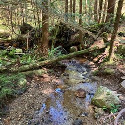
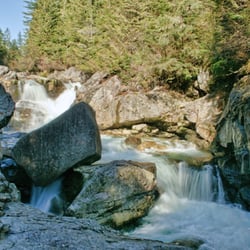
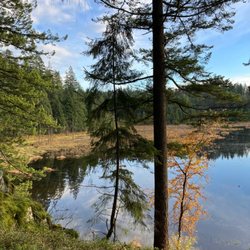
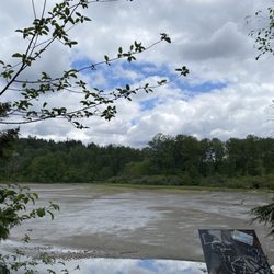
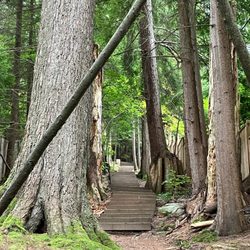
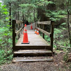
Surprisingly nice hike in the middle of nowhere Coquitlam. Had no idea this existed until recently. Basically it's the Coquitlam version of the Grouse Grind, but much tamer. 2.92km horizontal, 242m vertical according to the website PDF. The website says 2.2km for some reason - I think they're measuring from the Lansdowne parking lot. From Runnel Drive, it's basically 1/3 the vertical of the Grind, but a longer walk overall. Parking is available in several lots along the length of the path. For the full experience, park at the bottom of the valley (Runnel Drive). There are also parking lots accessible from Lansdowne and Panorama (major streets farther up the mountain), if one wants a shorter version. The path basically follows a set of BC Hydro power lines up the mountain. There are warning signs about potential electric shocks, though I imagine this probably only applies during wet weather. The path itself is divided into several sections. The "crunch" section" is technically the 3rd section of 6 (N side of Lansdowne), where there are 2 sets of stairs (some 500 steps) going up what is arguably the steepest section. Guessing they built 2 sets of stairs to facilitate 2 way traffic. I was told the proper travelling convention is counterclockwise. In other words, take the stairs on the "right" side. The stairs are pretty well built, with wire mesh nailed into the steps to prevent slipping. There are mini signs of encouragement along the way. I got a kick out of these. My only complaint is that the step tread (horizontal "depth") is a bit too wide. As in I couldn't decide whether to go up 1 or 2 steps at a time. This really threw off my pace. After the stairs section, the rest of the Crunch is actually a nice gentle uphill path. There are some more stairs here and there, but nothing too crazy (up to 20 steps at a time). The end of the Crunch is at Eagle Mountain Drive, where there's a 2.25km trail marker. To be honest, they really need to mark the end better. The trail actually continues further up the mountain, and I only knew this was the point to turn around because someone in the group had done it before. After walking all the way up, take a break, and enjoy the walk back down. Great time to take some photos, and look at the Runnel Drive parking lot way at the bottom of the valley. There is a lookout point partially down the length of the stairs section (accessible on the "downhill" steps). To be honest, this is a great alternative to the Grouse Grind. I was actually quite impressed. Nice views, no gondola fee, no seasonal limitations, way fewer people, and non overpriced restaurants nearby. What more can one ask for? read more
 - Hiking Near Me - Coquitlam, British Columbia")
 - Hiking Near Me - Coquitlam, British Columbia")
 - Hiking Near Me - Coquitlam, British Columbia")

 - Hiking Near Me - Coquitlam, British Columbia")
 - Hiking Near Me - Coquitlam, British Columbia")
 - Hiking Near Me - Coquitlam, British Columbia")
 - Hiking Near Me - Coquitlam, British Columbia")
 - Hiking Near Me - Coquitlam, British Columbia")


After hearing about the Coquitlam Crunch for many years from various friends (workout aspect included), I finally decided to try the hike for myself. From my "out-of-towner" experience, I saw a ton of pros and some cons about the Crunch. Nearly the entirety of the trail is situated underneath high power voltage lines, so I suspect the city wanted to make that space as useful as possible (that's my personal theory, so a pro if the city is actually trying to do that). It can be a little unsettling if you have sensitive ears and you can hear the hum of the high voltage electricity above you. PRO: The trail and related parking is free. I found parking in the lot at the trailhead just off of Runnell Drive (across the street from the Coquitlam Grill), though in my drive around the area I saw a lot of walkers using the street parking off Lansdowne. As of writing this review, I also saw construction for a new parking lot close to Bramble Park. CON: A bit confusing to find the parking spot I wanted. The trail website I used originally directed me to the parking lot off Lansdowne (which I suspect was closed) and was about halfway up the trail. Finally had to resort to Google giving me a different parking lot, which turned out to be the one by Runnel Drive and the one I wanted. PRO: The trail itself routes through a few parks, off-leash dog areas (dogs can use the trail as long as they are on-leash) and schools, and great washroom facilities are located along the route. I noted one at the field by Eagle Ridge Park, and another set about halfway up the trail. I also noted a number of benches along the trail, in case you wanted to sit and take a breather and look at the city below. CON: The trail winds it way across a number of streets. There are crosswalks at each one, but after I crossed the street I wasn't always sure where the trail continued. Since I was there mid-day, I managed to follow other walkers to the start of the next section of the trail. I wonder if the city could put some more visible signs to say "Coquitlam Crunch this way" after you cross the street. PRO: A good leg workout similar to the Grind, without having to make the long drive there (especially if you are from the suburbs). Lower half consists of stairs that are much easier to navigate in comparison, and I loved the feeling of getting a good workout on the Crunch, without feeling like I was going to pass out. The top half is a mix of paved road or gravel. Don't be fooled though, I did work up a very good sweat especially when the vast majority of the trail is out in open! Verdict: If this is your first time coming, research where you want to park. It may be a more convenient location for an outdoor workout, versus the grind (depending on where you live). A more forgiving trail than the Grouse Grind, but you can still work up a great sweat! read more


Grateful to have had the best weather of the year to conquer the Coquitlam Crunch. This is much easier than the Grouse Grind and more enjoyable. More open area to take a deep breath of fresh air. Easier when passing a group to respect personal space. read more


I tried here for casual urban hike last week. Yes, as no shades to the top, very warm. But I found cool breeze dried out sweat quickly. Very pleasant and easy hike for me. They have lots of parking. But if you want to avoid heat inside of your car, I recommend public swimming pool's parking near there. Bring your water and sunglasses. Again, no shade. read more


Is the CC crunch nice yes.Parking is plentiful when I figured out where it was. I've done the Grouse grind many times and if you use that as the standard the Crunch is a nice stroll in the park. I like the makings on the stairs to give you an idea of your progress. The stairs are done well with a metal mesh over top to give you a good grip. The views are nice as well It's a great idea in the wrong location in my opinion. The electric transmission towers are part of the trail. It was very unsettling when I touched my dog and felt a continuous shock. I thought he had a wasp in his fur. The effects of electric magnetic fields are real. I would skip it and do the Grind or another alternative hike. read more

4 years ago
great idea to create a trail for people to exercise and enjoy walks outside. not hard but can be challenge if you want to make it so. read more

7 years ago
12 years ago
If you find the Grouse Grind too daunting, this is a decent alternative. Especially if you're already in the area. It varies between steep and almost flat, so it's a bit like an interval workout. The terrain varies between gravel and pavement. The first third of it is made up of steps which I find to be the hardest part. After that, it gets easier. It takes me about 35 minutes to hike up and just less than that to get back down. And that's starting from the Guildford Way starting point (between the public pool and elementary school). I usually park at the field over by the Tim Horton's, which is good planning because you can have lunch after, or at least an Iced Cap. read more


8 years ago
10 years ago
The base of this trail is accessible from Landsdowne drive. Driving around the neighbourhood it wasn't easily apparent where the trail began. However just ahead of Charter Hill Dr on Landsdowne there is a little board directing people to the parking lot at the base of the trail. This is an easy hike, more of a stroll if you are fit. It took us about an hour up and downhill with quite a few breaks. There are about 400 steps in the beginning of the trail making it easy to hike during rains. Supposed to have some wild life and birds but we only spotted ravens and some wild berry/fern plants. The view is passable. On the whole, an undemanding hike. Can be skipped! read more


9 years ago
11 years ago
More info about Coquitlam Crunch Trail
Review Highlights - Coquitlam Crunch Trail
You might also consider


Why does Yelp recommend reviews?
Coquitlam Crunch Trail - hiking - Updated July 2026
People found Coquitlam Crunch Trail by searching for…
Things to Do in Coquitlam, British Columbia
Playgrounds in Coquitlam, British Columbia
Hiking Trails in Coquitlam, British Columbia
Watch Sunset in Coquitlam, British Columbia
Dog Swimming in Coquitlam, British Columbia
Things to Do on a Rainy Day in Coquitlam, British Columbia
Secret Spots in Coquitlam, British Columbia
Fireworks in Coquitlam, British Columbia
Sunset in Coquitlam, British Columbia
Views in Coquitlam, British Columbia
Stairs Workout in Coquitlam, British Columbia
Night View in Coquitlam, British Columbia
Swimming Lakes in Coquitlam, British Columbia
BBQ Park in Coquitlam, British Columbia
Picnic Areas in Coquitlam, British Columbia
Secluded Spots in Coquitlam, British Columbia
Off Road Trails in Coquitlam, British Columbia
Running Track in Coquitlam, British Columbia
Walking Trail in Coquitlam, British Columbia
Scenic Drive in Coquitlam, British Columbia
Off Leash Dog Hikes in Coquitlam, British Columbia
Places to Take Pictures in Coquitlam, British Columbia
Browse Articles
Browse Brands
Related Searches in Coquitlam, BC
Affordable Kayak Rental Services in Coquitlam, British Columbia
Best Fishing Locations and Guides in Coquitlam, British Columbia
Best Off Leash Dog Parks in Coquitlam, British Columbia
Best Places for Horseback Riding in Coquitlam, British Columbia
Best Water Parks for Kids in Coquitlam, British Columbia
Check Out Great Playgrounds in Coquitlam, British Columbia
Check Out Off Road Trails in Coquitlam, British Columbia
Discover Baseball Fields Around Coquitlam, British Columbia
Discover Beautiful Garden Spots in Coquitlam, British Columbia
Discover Free Parking Options in Coquitlam, British Columbia
Discover Fun Toddler Parks in Coquitlam, British Columbia for Your Little One
Discover Lakes & Ponds to Explore in Coquitlam, British Columbia
Discover Popular Photo Spots in Coquitlam, British Columbia
Discover Scenic Mountain Bike Trails Near Coquitlam, British Columbia
Discover Scenic Waterfall Spots in Coquitlam, British Columbia
Discover Soccer Fields in Coquitlam, British Columbia Near You
Discover the Best Beaches in Coquitlam, British Columbia
Discover the Best Kids Park Spots in Coquitlam, British Columbia
Discover the Best Night Hike Trails in Coquitlam, British Columbia
Discover the Best Running Track in Coquitlam, British Columbia
Enjoy Camping Adventures Around Coquitlam, British Columbia
Enjoy Exciting Mountain Biking Adventures in Coquitlam, British Columbia
Enjoy Kayaking Adventures in Coquitlam, British Columbia
Enjoy Tent Camping Spots Around Coquitlam, British Columbia
Enjoy Water Activities and Fun in Coquitlam, British Columbia
Enjoy the Best Family Activities in Coquitlam, British Columbia
Enjoy the Best Picnic Spots and Ideas in Coquitlam, British Columbia
Enjoy the Best Tubing Experiences in Coquitlam, British Columbia
Enjoy the Best Walking Trails in Coquitlam, British Columbia
Exciting Cliff Jumping Spots in Coquitlam, British Columbia
Experience Thrilling White Water Rafting in Coquitlam, British Columbia
Explore Beautiful Botanical Gardens in Coquitlam, British Columbia
Explore Beautiful Parks and Green Spaces in Coquitlam, British Columbia
Explore Family-Friendly Zoos and Wildlife in Coquitlam, British Columbia
Explore Free Picnic Areas Around Coquitlam, British Columbia
Explore Free Things to Do Around Coquitlam, British Columbia
Explore Fun Activities to Do in Coquitlam, British Columbia
Explore Nature Spots Around Coquitlam, British Columbia
Explore Parks With Pull Up Bars in Coquitlam, British Columbia
Explore Popular Campgrounds Near Coquitlam, British Columbia
Explore Popular Picnic Areas Around Coquitlam, British Columbia
Explore Popular RV Parks Around Coquitlam, British Columbia
Explore Popular Recreation Centers Around Coquitlam, British Columbia
Explore Scenic Lakes to Visit in Coquitlam, British Columbia
Explore Top Dog Parks in Coquitlam, British Columbia Near You
Explore Top Water Parks in Coquitlam, British Columbia Today
Explore the Best Beach Spots in Coquitlam, British Columbia
Explore the Best Boating Spots in Coquitlam, British Columbia
Find Beautiful Views in Coquitlam, British Columbia
Find Parks and Recreation Activities in Coquitlam, British Columbia
People who viewed Coquitlam Crunch Trail also viewed
Baden Powell Trail
10 reviews
Deep Cove
Quarry Rock
55 reviews
Deep Cove
Lower Seymour Conservation Reserve
16 reviews
Burnaby Lake Regional Nature Park
13 reviews
Pacific Spirit Regional Park
53 reviews
UBC
Central Park
32 reviews
Metrotown
Lighthouse Park
68 reviews
Traboulay Poco Trail
3 reviews
Vancouver Seawall
113 reviews
Coal Harbour
Jug Island Trail
5 reviews