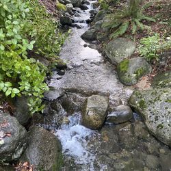
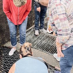
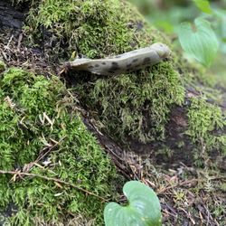
Mt Seymour Photos


You might also consider
More like Mt Seymour
Recommended Reviews - Mt Seymour
Start your review...

Reviews With Photos

Went up on a Saturday. First time at this ski resort. Parking is free, there is a shuttle on the bottom of the mountain for a small fee, if you choose not to drive up. They don't/couldn't keep up with the conditions? The parking lot is an ice rink. I wouldn't suggest bringing grandma or grandpa/ handicapped here. It's not wheelchair friendly. The cafeteria and restaurant is basic but very tasty. It is absolutely beautiful up here, the vibe is absolutely different from the Grouse and Cypress.

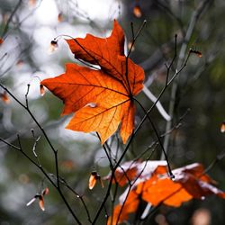
Great hike with amazing views! Im always looking for hikes that I can so in less then a couple of hours, this is just perfect. It was pretty muddy when I went, but getting dirty is part of it, right? I went Monday morning and it was quite, only saw one other person going up. When I reached the top their were only 2 people, and they shortly left. I had the mountain all to myself. Peaceful!!!! I heard during the weekend especially summer months it gets busy. So I recommend going during the week. Highlights: Its free Free parking Well marked trail Nice view at top Warning lots of mosquitos in the summer!

I love snowboarding and I have to say out of all the mountains Mt. Seymour would be the disappointing one. They don't have challenging runs or many runs compared to its competitor. Only thing i like is that every year they do Monday as ladies night. Which means ladies pay $5 or free to go in. But I have never done ladies night because it is a Monday and I am always busy on Mondays Came here snowshoeing with a friend. It was fun but we went more than half way and we saw a avalache warning sign and had to turn back because we were not equipped. There is not much to see in the snowshoe trail. But the good part is that because we came when 1 of the trail was closed, they gave us a 10% discount and we didn't even have to ask for it. I rented my snowshoe from them and the right feet wasn't working properly. it kept on coming loose. As well, when I got my pass they didn't tell me where I can get the hook to hook my day pass onto my jacket. So i ended up randomly sticking it somewhere.

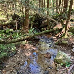
Vancouverites are spoiled for choice in the mountain department, so there are a lot of differing opinions on where to go, but for a visiting flatlander without a car who's looking to spend an easy day in the mountains, with some beautiful views of Vancouver, Mt. Seymour is a great place to start. There is currently a shuttle bus that picks up twice daily just outside of the Rupert Skytrain stop. It's $8 CAD cash per way. Check Mt. Seymour's website for specific times, but note that there are only a few shuttles returning to Rupert throughout the day, otherwise the shuttle picks up/drops off at the less central Parkdale Community Centre location. The vehicle is a converted school bus, but it runs like a tank (which you want when it's winding through snowy precarious mountain roads). The region has recently had record once-in-a-decade snowfalls, so I wanted to try out the snowshoe trails. If you don't already have snowshoes, it's cheaper to rent them in town than on the mountain, but most businesses open too late to then catch the shuttle bus, so I ended up getting them on Mt. Seymour. As others have noted, you have to pay for a trail access pass along with your equipment rental. The total rental/trail pass combo will run you just under $30. They try to gauge the equipment return time to coordinate with sunset, so the later it is in the season, the longer you'll likely be able to use your rentals. The trail up to Dog Mountain was a good workout for a beginner snowshoer, if a bit sporty in places. The nature of the hikes is obviously contingent on the amount of snow that they have up there, so others could experience completely different conditions from the day I was there. The view on the summit of Dog Mountain opens out onto a comprehensive sweep of the city of Vancouver and its surroundings. I also tried out several trails on the other side of Mt. Seymour's snowboarding/skiing area. The routes were well marked, with maps and stakes posted at regular intervals. At times it was so quiet, with the snow muting all sounds, that I could virtually hear my heartbeat. Total magic. The noisy cafeteria-style food hut has all the usual fried and junky offerings like fries and chicken tenders, so bring snacks from home if you want some healthier and less pricey options.

Several websites have listed the Mount Seymour hike (to the peak) as one of the "top ten" around Vancouver for SPECTACULAR, panoramic scenery of the lower mainland. It also listed the hike as "Intermediate" in difficulty. Having lived in Vancouver for 20 years and being a pretty experienced hiker, from the descript, I expected the vistas to knock me out of my hiking boots and onto my flat sorry excuse for an Asian ass. My formula for a good hike is simple - the beauty of the hike should meet or exceed my exertion level on the hike. Sorry, but I'm just selfish that way. Nothing pisses me off more than scrambling over boulders and rock faces, tripping over big tree roots, dehydrating in the searing heat without little opportunity for shade, sliding down slope after mountain of loose rocks, only to be met with pond after puddle of standing, muddy water that resembles a hippopotamus' wet dream of a mud hole, or sewage plant run off. The trail starts off innocently enough - on the easy side of moderate with moderate elevation punctuated by small snippets of sharper climbs. The terrain is also do-able - some larger and loose rocks. Dried-up creek beds are covered with little wooden bridge-ettes, which are all in good shape. A section of loose rock is even kept under control with some wire fencing. The trail is also well-maintained, cleared of foliage, with markers EVERYWHERE. You'd have to be an idiot-and-a-half to get hopelessly lost (and I'm the idiot to prove it). It's as if the trail maintenance people could read my mind - every time I thought, "Hey, where the @#*$&# am I?" another little orange marker or blue-felt tipped sign appears on a rock or a tree. I did this hike as a clueless and directionless woman and did not get lost once. The trail is 9km roundtrip with 450m elevation gain. For the first 2km or so, the hike is...how shall I put this - as boring as the top of Donald Trump's pasty bald head. (His toupee is much more enthralling.) With some Pacific Northwest hikes you can enjoy the stately evergreens flanking either side of the trail, wildflowers, or even berry bushes to munch on. Nothing like that here. Trail is mostly exposed and full of rocks and boulders, with the occasional tree root thrown in for good measure. Each step may also be a good climb up, sometimes requiring steady pacing or even hands. Despite this being one of the driest summers, the dirt on the ground was also curiously damp. At about 2.5km to 3.0km into the trail, the trail markers start getting spotty. This is unfortunate, as this is where the trail really gets down to business. Endless climbs then dips requiring very careful foot placement. Don't be lulled by the scant 450m gain, because this is a NET GAIN. There is a lot of unnecessary ups and downs on this trail. Did you hear a woman cursing up and down the Seymour trail on Thursday, July 30, then proclaim, "Bears, take me now! Serenity now!" That was me. There are two peaks before reaching Seymour - ones which overlook Indian Arm and the lower mainland - and both are are welcomed sight, especially compared to the bland rice cake boredom of the first 2kms. However - nothing to tip it off the scale of wowness for me. After the second peak and before Seymour a big sign tells you that things are going to get hairy after this point. By this they mean big boulders, narrow rocky paths that drop off on the other side. In dry weather, they were fine, but I could imagine that, in the rain and slick, this hike could be hell. I brought my 5lb (2.72kgs) DSLR and took less than 5 pictures, and this is an indication of how bland the hike was for me. If you're from a country where ISIS is a constant feature in your life, this hike will seem out-of-this-world for you. My memories are shin splints in both legs and thigh muscles which are sore even two days later. If you go, bring plenty of water (unless you want to get dysentery by venturing to drink from the puddles), have good hiking boots with stable ankle support. This is not mentioned in any of the sites I found online. This is a good workout, but so is the Marine Corps training program...and you get to meet a lot of cute guys in the Marine Corps, but I was the only one on the hike for most of the way up at 10am.

Do it for the gorgeous view at the end. It's worth it!! This is about a 2.5 hour hike, branching off the Seymour main trail to the Dog Mountain Trail.On the way, you will pass by First Lake, a small lake that's an indicator of the beginning of the Dog Mountain trail. There's lots of tree roots and large boulders on the way, so there is some climbing involved. It wasn't too busy when we went, and there were a lot of families doing it. At the top, the view is stunning. There's smooth rocks up there for you to relax and perhaps enjoy some lunch/ snacks. I agree with Kat S that this was a very buggy trail. We were constantly followed by bugs, and the buzzing drove us crazy. Bring bug spray and sunscreen, and you should be all set for a spectacular view at the top!

The first time I attempted this hike it was rainy (warning sign 1) and all of Seymour was pretty much inside a cloud. I literally could not see 10 feet in front of me (warning sign 2). We got to the parking lot and there were absolutely no cars there (warning sign 3) except for one tourist who got out to take pictures. Pretty sure all she got were white and grey pixels in the photo. We went to get our Grouse Grind on instead. Fast forward two weeks later and we tried again. This time 30 degrees and not a cloud in sight. Thankfully most of the trail is shaded so even on a hot day it isn't too bad. I would rate the hike as easy as there is very little elevation gain. Much of the elevation gain is done in a vehicle before you get to the parking lot. The hike is more obstacle training as there are many roots, rocks and uneven surfaces to get through. It's a short hike to the lookout at only 2.5 km one way and takes approximately 45 minutes to an hour to get there. Perhaps budget 2.5 to 3 hours round trip. Once at the lookout you get great views overlooking Burnaby and Vancouver. When I went during the afternoon on a mid-summer day it was a bit hazy to see off in the distance. I think a sunset view would be absolutely stunning. Overall, it's a nice easy hike that anyone can do. Personally I enjoy more of a challenge/workout and it would have been nice if it were a tad less hazy but nonetheless still a gem that you have to do at least once. If I could, I'd give Dog Mountain 3.5 stars. Unfortunately I can't comment on snowshoeing the trail, but it would seem like a nice workout during the winter.

Re: snowshoeing @ Seymour Great place to do some snowshoeing on the week-end. Feel free to bring your dog as well. People have let their dogs off-leash but there are park rangers that patrol the trails and you could be fined if they catch you! Unfortunately, if you are just doing snowshoeing, you are only able to park on the hill and not in the parking lots. Expect a 15-20 minute hike to the trails from your place on the hill. The earlier you go the better as you get a closer parking spot. After 10 am on the weekend you'll be hiking longer than that!

Mt Seymour has excellent views of the city on a clear sunny day. You can also see heavily snow covered trees reminiscent of a Dr. Seuss world. I think the mountain could do better on its snowshoe rental procedure. Today, it seemed as if they were understaffed (but that could be because it was the day of New Year's Eve). I went in just after 2:30 to rent snowshoes just till 4:00, when they close. I had to pay for a rental & trail pass at almost full price $26. They didn't offer the option of snowshoe rentals without the trail pass. One trail is free to use, and since my friend had her own snowshoes, we planned to walk the free trail. Nonetheless, I still had to pay for a trail pass I didn't use. I recommend going to this mountain for its great location, trails and views. If skiing, it is worth your while for a day or evening. I've tried some green & blue runs here. If snowshoeing, it's better to bring your own pair & walk the free trail. Otherwise, make sure you come early enough to make your rental & pass worth the cost.

2 months ago
I loved the two mountains and lifts we went on. They had a good Buddha bowl at the cafeteria. I went on a weekday afternoon and my total was around $120 for renting skis set and lift ticket with free bus ride. Staff are nice and friendly. Highly recommend! read more


1 year ago
Lovely trails for hiking and snowshoeing, great views of Vancouver, Burnaby and Coquitlam, from easy to more difficult trail levels, Mt Seymour is a great options especially in winter. If you don't have a car like me, the winter shuttle bus from Parkgate community center is very convinient and cheap. We also have done ski classes at Seymour. Very affordable for 159 $ and include clothes and equipment rental for 2 hours. Great slopes for beginners. We will be back for more! read more


5 months ago
1 year ago
1 year ago
1 year ago
8 years ago
Went up on a Saturday. First time at this ski resort. Parking is free, there is a shuttle on the bottom of the mountain for a small fee, if you choose not to drive up. They don't/couldn't keep up with the conditions? The parking lot is an ice rink. I wouldn't suggest bringing grandma or grandpa/ handicapped here. It's not wheelchair friendly. The cafeteria and restaurant is basic but very tasty. It is absolutely beautiful up here, the vibe is absolutely different from the Grouse and Cypress. read more


5 years ago
Great hike with amazing views! Im always looking for hikes that I can so in less then a couple of hours, this is just perfect. It was pretty muddy when I went, but getting dirty is part of it, right? I went Monday morning and it was quite, only saw one other person going up. When I reached the top their were only 2 people, and they shortly left. I had the mountain all to myself. Peaceful!!!! I heard during the weekend especially summer months it gets busy. So I recommend going during the week. Highlights: Its free Free parking Well marked trail Nice view at top Warning lots of mosquitos in the summer! read more


I love snowboarding and I have to say out of all the mountains Mt. Seymour would be the disappointing one. They don't have challenging runs or many runs compared to its competitor. Only thing i like is that every year they do Monday as ladies night. Which means ladies pay $5 or free to go in. But I have never done ladies night because it is a Monday and I am always busy on Mondays Came here snowshoeing with a friend. It was fun but we went more than half way and we saw a avalache warning sign and had to turn back because we were not equipped. There is not much to see in the snowshoe trail. But the good part is that because we came when 1 of the trail was closed, they gave us a 10% discount and we didn't even have to ask for it. I rented my snowshoe from them and the right feet wasn't working properly. it kept on coming loose. As well, when I got my pass they didn't tell me where I can get the hook to hook my day pass onto my jacket. So i ended up randomly sticking it somewhere. read more


7 years ago
9 years ago
Vancouverites are spoiled for choice in the mountain department, so there are a lot of differing opinions on where to go, but for a visiting flatlander without a car who's looking to spend an easy day in the mountains, with some beautiful views of Vancouver, Mt. Seymour is a great place to start. There is currently a shuttle bus that picks up twice daily just outside of the Rupert Skytrain stop. It's $8 CAD cash per way. Check Mt. Seymour's website for specific times, but note that there are only a few shuttles returning to Rupert throughout the day, otherwise the shuttle picks up/drops off at the less central Parkdale Community Centre location. The vehicle is a converted school bus, but it runs like a tank (which you want when it's winding through snowy precarious mountain roads). The region has recently had record once-in-a-decade snowfalls, so I wanted to try out the snowshoe trails. If you don't already have snowshoes, it's cheaper to rent them in town than on the mountain, but most businesses open too late to then catch the shuttle bus, so I ended up getting them on Mt. Seymour. As others have noted, you have to pay for a trail access pass along with your equipment rental. The total rental/trail pass combo will run you just under $30. They try to gauge the equipment return time to coordinate with sunset, so the later it is in the season, the longer you'll likely be able to use your rentals. The trail up to Dog Mountain was a good workout for a beginner snowshoer, if a bit sporty in places. The nature of the hikes is obviously contingent on the amount of snow that they have up there, so others could experience completely different conditions from the day I was there. The view on the summit of Dog Mountain opens out onto a comprehensive sweep of the city of Vancouver and its surroundings. I also tried out several trails on the other side of Mt. Seymour's snowboarding/skiing area. The routes were well marked, with maps and stakes posted at regular intervals. At times it was so quiet, with the snow muting all sounds, that I could virtually hear my heartbeat. Total magic. The noisy cafeteria-style food hut has all the usual fried and junky offerings like fries and chicken tenders, so bring snacks from home if you want some healthier and less pricey options. read more


Several websites have listed the Mount Seymour hike (to the peak) as one of the "top ten" around Vancouver for SPECTACULAR, panoramic scenery of the lower mainland. It also listed the hike as "Intermediate" in difficulty. Having lived in Vancouver for 20 years and being a pretty experienced hiker, from the descript, I expected the vistas to knock me out of my hiking boots and onto my flat sorry excuse for an Asian ass. My formula for a good hike is simple - the beauty of the hike should meet or exceed my exertion level on the hike. Sorry, but I'm just selfish that way. Nothing pisses me off more than scrambling over boulders and rock faces, tripping over big tree roots, dehydrating in the searing heat without little opportunity for shade, sliding down slope after mountain of loose rocks, only to be met with pond after puddle of standing, muddy water that resembles a hippopotamus' wet dream of a mud hole, or sewage plant run off. The trail starts off innocently enough - on the easy side of moderate with moderate elevation punctuated by small snippets of sharper climbs. The terrain is also do-able - some larger and loose rocks. Dried-up creek beds are covered with little wooden bridge-ettes, which are all in good shape. A section of loose rock is even kept under control with some wire fencing. The trail is also well-maintained, cleared of foliage, with markers EVERYWHERE. You'd have to be an idiot-and-a-half to get hopelessly lost (and I'm the idiot to prove it). It's as if the trail maintenance people could read my mind - every time I thought, "Hey, where the @#*$&# am I?" another little orange marker or blue-felt tipped sign appears on a rock or a tree. I did this hike as a clueless and directionless woman and did not get lost once. The trail is 9km roundtrip with 450m elevation gain. For the first 2km or so, the hike is...how shall I put this - as boring as the top of Donald Trump's pasty bald head. (His toupee is much more enthralling.) With some Pacific Northwest hikes you can enjoy the stately evergreens flanking either side of the trail, wildflowers, or even berry bushes to munch on. Nothing like that here. Trail is mostly exposed and full of rocks and boulders, with the occasional tree root thrown in for good measure. Each step may also be a good climb up, sometimes requiring steady pacing or even hands. Despite this being one of the driest summers, the dirt on the ground was also curiously damp. At about 2.5km to 3.0km into the trail, the trail markers start getting spotty. This is unfortunate, as this is where the trail really gets down to business. Endless climbs then dips requiring very careful foot placement. Don't be lulled by the scant 450m gain, because this is a NET GAIN. There is a lot of unnecessary ups and downs on this trail. Did you hear a woman cursing up and down the Seymour trail on Thursday, July 30, then proclaim, "Bears, take me now! Serenity now!" That was me. There are two peaks before reaching Seymour - ones which overlook Indian Arm and the lower mainland - and both are are welcomed sight, especially compared to the bland rice cake boredom of the first 2kms. However - nothing to tip it off the scale of wowness for me. After the second peak and before Seymour a big sign tells you that things are going to get hairy after this point. By this they mean big boulders, narrow rocky paths that drop off on the other side. In dry weather, they were fine, but I could imagine that, in the rain and slick, this hike could be hell. I brought my 5lb (2.72kgs) DSLR and took less than 5 pictures, and this is an indication of how bland the hike was for me. If you're from a country where ISIS is a constant feature in your life, this hike will seem out-of-this-world for you. My memories are shin splints in both legs and thigh muscles which are sore even two days later. If you go, bring plenty of water (unless you want to get dysentery by venturing to drink from the puddles), have good hiking boots with stable ankle support. This is not mentioned in any of the sites I found online. This is a good workout, but so is the Marine Corps training program...and you get to meet a lot of cute guys in the Marine Corps, but I was the only one on the hike for most of the way up at 10am. read more


Do it for the gorgeous view at the end. It's worth it!! This is about a 2.5 hour hike, branching off the Seymour main trail to the Dog Mountain Trail.On the way, you will pass by First Lake, a small lake that's an indicator of the beginning of the Dog Mountain trail. There's lots of tree roots and large boulders on the way, so there is some climbing involved. It wasn't too busy when we went, and there were a lot of families doing it. At the top, the view is stunning. There's smooth rocks up there for you to relax and perhaps enjoy some lunch/ snacks. I agree with Kat S that this was a very buggy trail. We were constantly followed by bugs, and the buzzing drove us crazy. Bring bug spray and sunscreen, and you should be all set for a spectacular view at the top! read more


5 years ago
The first time I attempted this hike it was rainy (warning sign 1) and all of Seymour was pretty much inside a cloud. I literally could not see 10 feet in front of me (warning sign 2). We got to the parking lot and there were absolutely no cars there (warning sign 3) except for one tourist who got out to take pictures. Pretty sure all she got were white and grey pixels in the photo. We went to get our Grouse Grind on instead. Fast forward two weeks later and we tried again. This time 30 degrees and not a cloud in sight. Thankfully most of the trail is shaded so even on a hot day it isn't too bad. I would rate the hike as easy as there is very little elevation gain. Much of the elevation gain is done in a vehicle before you get to the parking lot. The hike is more obstacle training as there are many roots, rocks and uneven surfaces to get through. It's a short hike to the lookout at only 2.5 km one way and takes approximately 45 minutes to an hour to get there. Perhaps budget 2.5 to 3 hours round trip. Once at the lookout you get great views overlooking Burnaby and Vancouver. When I went during the afternoon on a mid-summer day it was a bit hazy to see off in the distance. I think a sunset view would be absolutely stunning. Overall, it's a nice easy hike that anyone can do. Personally I enjoy more of a challenge/workout and it would have been nice if it were a tad less hazy but nonetheless still a gem that you have to do at least once. If I could, I'd give Dog Mountain 3.5 stars. Unfortunately I can't comment on snowshoeing the trail, but it would seem like a nice workout during the winter. read more


Re: snowshoeing @ Seymour Great place to do some snowshoeing on the week-end. Feel free to bring your dog as well. People have let their dogs off-leash but there are park rangers that patrol the trails and you could be fined if they catch you! Unfortunately, if you are just doing snowshoeing, you are only able to park on the hill and not in the parking lots. Expect a 15-20 minute hike to the trails from your place on the hill. The earlier you go the better as you get a closer parking spot. After 10 am on the weekend you'll be hiking longer than that! read more

6 years ago
Mt Seymour has excellent views of the city on a clear sunny day. You can also see heavily snow covered trees reminiscent of a Dr. Seuss world. I think the mountain could do better on its snowshoe rental procedure. Today, it seemed as if they were understaffed (but that could be because it was the day of New Year's Eve). I went in just after 2:30 to rent snowshoes just till 4:00, when they close. I had to pay for a rental & trail pass at almost full price $26. They didn't offer the option of snowshoe rentals without the trail pass. One trail is free to use, and since my friend had her own snowshoes, we planned to walk the free trail. Nonetheless, I still had to pay for a trail pass I didn't use. I recommend going to this mountain for its great location, trails and views. If skiing, it is worth your while for a day or evening. I've tried some green & blue runs here. If snowshoeing, it's better to bring your own pair & walk the free trail. Otherwise, make sure you come early enough to make your rental & pass worth the cost. read more


Oh my!! What a gorgeous hike without the same level of strenuousness, or as far as Squamish Chief! It took us about 3 hours, but at this time of the year and on such a warm sunny day, we were not expecting there to be packed snow/ice on the trail still, The trail markers make it fairly easy to follow for the most part, except for a few spots. There aren't that many signs pointing the way so you pretty much need to know where you're going, check the website or ask the other hikers if you're confused. I loved every moment of this hike though, even when I did fall into ice holes or fell flat on my face in the mud on the way back. The view was well worth it! Go on a sunny, clear day. read more

14 years ago
12 years ago
14 years ago
14 years ago
9 years ago
Hiked during summer time. The trail to Mt. Seymour is close so we didn't have a chance to see the top of it. The worse part is flys. There were so many flys that you could never get ride of. They follow you everywhere!!! Don't talk on the trail, otherwise flys might get into your mouth:(( read more


14 years ago
First time here and we had a great time. We are not the most experienced skiers but we enjoyed the various green then blue runs. Staff were friendly and helpful throughout the day. The grill made a pretty darn good chicken burger for the price. Views from the top of the chairlift were amazing with the sun showing up periodically as the clouds blew by and the sunset was amazing! We will be back! read more


17 years ago
17 years ago
12 years ago
7 years ago
Page 1 of 2
More info about Mt Seymour
1700 Mount Seymour Road
North Vancouver, BC V7G 1L3
Canada
Directions
(604) 986-2261
Call Now
Visit Website
https://mtseymour.ca
Hours
Indoor Amenities
Outdoor Amenities
Other Amenities
Mt Seymour Reviews in Other Languages
Review Highlights - Mt Seymour


Why does Yelp recommend reviews?
4 reviews that are not currently recommended
The reviews below are not factored into the business's overall star rating.
10 years ago
13 years ago
15 years ago
13 years ago
Mt Seymour - hiking - Updated May 2026
People found Mt Seymour by searching for…
Lakes in North Vancouver, British Columbia
BBQ Park in North Vancouver, British Columbia
Fun Things to Do at Night in North Vancouver, British Columbia
Night View in North Vancouver, British Columbia
Hidden Picnic Spots in North Vancouver, British Columbia
Scenic Drive in North Vancouver, British Columbia
Dog Parks in North Vancouver, British Columbia
Dog Swimming in North Vancouver, British Columbia
Lookout Points in North Vancouver, British Columbia
Campgrounds in North Vancouver, British Columbia
Running Track in North Vancouver, British Columbia
Night Hiking in North Vancouver, British Columbia
Off Leash Dog Hikes in North Vancouver, British Columbia
Watch Sunset in North Vancouver, British Columbia
Tourist Attractions in North Vancouver, British Columbia
Beautiful Views in North Vancouver, British Columbia
Photo Spots in North Vancouver, British Columbia
Romantic Picnic in North Vancouver, British Columbia
Off Road Trails in North Vancouver, British Columbia
Snow Play in North Vancouver, British Columbia
Free Things to Do in North Vancouver, British Columbia
Picnic Areas BBQ Pits in North Vancouver, British Columbia
Browse Articles
Browse Brands
Related Cost Guides
Related Searches in North Vancouver, BC
Affordable Bike Repair Services in North Vancouver, British Columbia
Affordable Kayak Rental Services in North Vancouver, British Columbia
Best Bike Rental Deals in North Vancouver, British Columbia
Best Electric Bike Rental Services in North Vancouver, British Columbia
Best Fishing Locations and Guides in North Vancouver, British Columbia
Best Hiking Shoes Available in North Vancouver, British Columbia
Best Places for Horseback Riding in North Vancouver, British Columbia
Best Sledding Spots and Fun in North Vancouver, British Columbia
Best Snowboard Rental Services in North Vancouver, British Columbia
Browse Used Skis Available Near North Vancouver, British Columbia
Buy Used Sports Equipment Near North Vancouver, British Columbia
Buy Warm Winter Clothes in North Vancouver, British Columbia
Buy or Rent Ski Equipment in North Vancouver, British Columbia Today
Check Out Off Road Trails in North Vancouver, British Columbia
Discover Scenic Mountain Bike Trails Near North Vancouver, British Columbia
Discover Scenic Waterfall Spots in North Vancouver, British Columbia
Discover Top Ski Clothing Options Near North Vancouver, British Columbia
Discover Used Outdoor Gear Deals in North Vancouver, British Columbia
Discover the Best Night Hike Trails in North Vancouver, British Columbia
Discover the Best Running Track in North Vancouver, British Columbia
Discover the Best Snow Park Activities in North Vancouver, British Columbia
Enjoy Camping Adventures Around North Vancouver, British Columbia
Enjoy Exciting Mountain Biking Adventures in North Vancouver, British Columbia
Enjoy Kayaking Adventures in North Vancouver, British Columbia
Enjoy Tent Camping Spots Around North Vancouver, British Columbia
Enjoy Water Activities and Fun in North Vancouver, British Columbia
Enjoy the Best Family Activities in North Vancouver, British Columbia
Enjoy the Best Picnic Spots and Ideas in North Vancouver, British Columbia
Enjoy the Best Walking Trails in North Vancouver, British Columbia
Exciting Cliff Jumping Spots in North Vancouver, British Columbia
Experience Scenic Gondola Rides in North Vancouver, British Columbia
Experience Thrilling Snowmobiling in North Vancouver, British Columbia
Experience Thrilling White Water Rafting in North Vancouver, British Columbia
Expert Ski Repair Services Available in North Vancouver, British Columbia
Explore BMX Bike Shops Near North Vancouver, British Columbia
Explore Beautiful Parks and Green Spaces in North Vancouver, British Columbia
Explore Free Things to Do Around North Vancouver, British Columbia
Explore Fun Activities to Do in North Vancouver, British Columbia
Explore Nature Spots Around North Vancouver, British Columbia
Explore Popular Campgrounds Near North Vancouver, British Columbia
Explore Scenic Lakes to Visit in North Vancouver, British Columbia
Explore Snow Conditions and Fun in North Vancouver, British Columbia
Explore Snowboarding Spots Around North Vancouver, British Columbia
Explore the Best Beach Spots in North Vancouver, British Columbia
Explore the Best Boating Spots in North Vancouver, British Columbia
Explore the Best Trail Options in North Vancouver, British Columbia
Find Beautiful Views in North Vancouver, British Columbia
Find Parks and Recreation Activities in North Vancouver, British Columbia
Find Quality Hiking Boots in North Vancouver, British Columbia
Find Quality Snowboard Wax Options in North Vancouver, British Columbia
People who viewed Mt Seymour also viewed
Hollyburn Mountain
8 reviews
Cypress Mountain
123 reviews
Grouse Mountain
378 reviews
Hollyburn Ridge - Cypress Provincial Park
3 reviews
Lynn Canyon Park
71 reviews
Lynn Valley
Grouse Grind
189 reviews
Eagle Bluffs
8 reviews
Coquitlam Crunch Trail
15 reviews
St. Mark's Summit
7 reviews
Pacific Spirit Regional Park
52 reviews
UBC