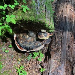
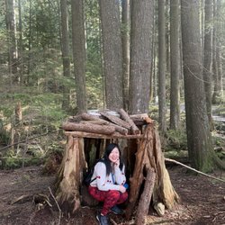
Eagle Bluffs Photos


More like Eagle Bluffs
Recommended Reviews - Eagle Bluffs
Start your review...

Reviews With Photos

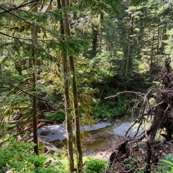
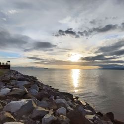
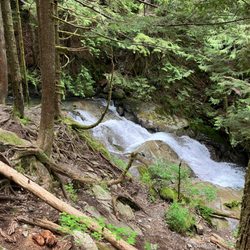
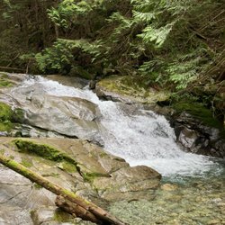
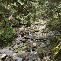
This is an all round very pleasant 8km hiking experience in Cypress Provincial Park which leads to a stunning end point at Eagle Bluffs with jaw-dropping views Vancouver, Burnaby, Bowen Island and Vancouver Island. It starts in the ski hill lifts section in Cypress Mountain, and you will hike up hill through a combination of dirt and rocky trails. After you will hike past small ponds and lakes. My favourite is Cabin Lake which is so beautiful, and it's a great place to stop and have a snack or go for a swim. The trails are mostly narrow, so you will have to yield to hikers coming towards your direction. This is not a very difficult hike, but I would classify it as moderate to intermediate. I saw quite of few senior citizens who looked like they were in their 70's to 80's doing this hike, so it isn't just for the younger crowd. I recommend wearing trail or hiking shoes or decent running shoes with good grip and brings at least 2 litres of water with lots of snacks if you're hiking on a warm sunny day.

This is an intermediate hike which will take an average person around 4 hours round trip. The beginning part is the steepest as you are hiking beside Cypress ski hill. Once you've done it, it is pretty much small ups and downs. There are signs to point you in the right direction. There are two ways to go, one longer route but less steep and the other is over the top part which is a little steep but gets you to your destination quicker. I like to do this a few times a year as the view is spectacular on a clear day. Bring a snack and enjoy the view.

This 8km round trip hike is worth it. The view at the end is spectacular. Enjoy your lunch there and bring a warm jacket cause it gets windy. There are tons of people on the very well marked trails so come early. The path can get slushy and muddy cause of the melting snow so bring good shoes.

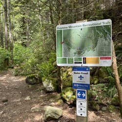
Rated as a moderately challenging hike I'd say Eagle Bluffs is a great hike if you want to start training your body for other hikes at Cypress like St. Marks Summit. At an estimated elevation gain of over 400m it has a great effort to reward ratio. The first 2kms are always talked about because it's switchbacks that are just dirt and loose rock. I've done this hike a handful of times and i'm always blown away by how many people I see wearing sandals and jeans. Good on them for being able to do it, but I don't recommend it, especially the sandals. The switchbacks on the way down will kill your feet and knees. Also, as much as I love dogs, I'm an owner myself, I wouldn't bring mine with me on this hike. It's just too taxing on their body, especially if it's a hot day. I saw a poor shitzhu yesterday panting like crazy on the way up. The trail can also get very busy and having a dog on a leash can cause a bit of a traffic and also make parts of the hike harder for you. Logistics: - Parking is at Cypress Bowl. - Bathrooms can be found at the lodge at the parking lot - You don't need a pass this year. - You want to take the Black Mountain Trail (aka The Baden Powell). Not the Howe Sound Crest Trail; this will take you to Bowen Lookout, St. Marks Summit, and beyond. read more


2 years ago
steep at the beginning of the trail which will eventually get easier after the 2.5 km mark. nice views. read more
This is an all round very pleasant 8km hiking experience in Cypress Provincial Park which leads to a stunning end point at Eagle Bluffs with jaw-dropping views Vancouver, Burnaby, Bowen Island and Vancouver Island. It starts in the ski hill lifts section in Cypress Mountain, and you will hike up hill through a combination of dirt and rocky trails. After you will hike past small ponds and lakes. My favourite is Cabin Lake which is so beautiful, and it's a great place to stop and have a snack or go for a swim. The trails are mostly narrow, so you will have to yield to hikers coming towards your direction. This is not a very difficult hike, but I would classify it as moderate to intermediate. I saw quite of few senior citizens who looked like they were in their 70's to 80's doing this hike, so it isn't just for the younger crowd. I recommend wearing trail or hiking shoes or decent running shoes with good grip and brings at least 2 litres of water with lots of snacks if you're hiking on a warm sunny day. read more


This is an intermediate hike which will take an average person around 4 hours round trip. The beginning part is the steepest as you are hiking beside Cypress ski hill. Once you've done it, it is pretty much small ups and downs. There are signs to point you in the right direction. There are two ways to go, one longer route but less steep and the other is over the top part which is a little steep but gets you to your destination quicker. I like to do this a few times a year as the view is spectacular on a clear day. Bring a snack and enjoy the view. read more


8 years ago
This 8km round trip hike is worth it. The view at the end is spectacular. Enjoy your lunch there and bring a warm jacket cause it gets windy. There are tons of people on the very well marked trails so come early. The path can get slushy and muddy cause of the melting snow so bring good shoes. read more


8 years ago
The Eagle Bluffs is a hike which takes you through Black Mountain from the base of the Cypress Mountain ski hill and is probably the most rewarding view for the amount of work you have to put in in the Vancouver area. When you look at the numbers, 4km and only 350m elevation gain? Easy peasy, right? Well I'm fairly certain all 350m comes within the first half hour of the hike. It takes you basically up the ski hill, following close to the ski lift, so ya, pretty steep. It's also all loose gravel for the most part so it will be tricky coming down. But once you actually get up to the top of the ski hill it's a fairly nice hike while passing a few small lakes along the way. You know you're getting close as you come down the other side of the mountain and the terrain and vegetation begins to change. Then you will finally arrive at a spectacular site overlooking Vancouver, Burnaby, Richmond and Bowen Island. Two hours work for a view like this? Totally worth it. Just be careful coming back when you hit the ski hill portion as it's extremely steep with many loose rocks! read more
More info about Eagle Bluffs
6000 Cypress Bowl Road
West Vancouver, BC V0N 1G0
Canada
Directions
Hours
Outdoor Amenities


Eagle Bluffs - hiking - Updated July 2026
People found Eagle Bluffs by searching for…
Lakes in West Vancouver, British Columbia
Things to Do in West Vancouver, British Columbia
Scenic Views in West Vancouver, British Columbia
Hiking Trails in West Vancouver, British Columbia
Beautiful Views in West Vancouver, British Columbia
Off Leash Dog Hikes in West Vancouver, British Columbia
Parks in West Vancouver, British Columbia
Night Walk in West Vancouver, British Columbia
Swimming Lakes in West Vancouver, British Columbia
Playgrounds in West Vancouver, British Columbia
Walking Trails in West Vancouver, British Columbia
Lakes & Ponds in West Vancouver, British Columbia
Lookout Points in West Vancouver, British Columbia
Night View in West Vancouver, British Columbia
View Points in West Vancouver, British Columbia
Hidden Picnic Spots in West Vancouver, British Columbia
Watch Sunset in West Vancouver, British Columbia
Kid Friendly Hiking Trails in West Vancouver, British Columbia
Running Trails in West Vancouver, British Columbia
Scenic Overlook in West Vancouver, British Columbia
Picnic Areas BBQ Pits in West Vancouver, British Columbia
Off Road Trails in West Vancouver, British Columbia
Browse Articles
Browse Brands
Related Searches in West Vancouver, BC
Affordable Kayak Rental Services in West Vancouver, British Columbia
Best Fishing Locations and Guides in West Vancouver, British Columbia
Best Places for Horseback Riding in West Vancouver, British Columbia
Best Sightseeing Experiences Available in West Vancouver, British Columbia
Best Water Parks for Kids in West Vancouver, British Columbia
Check Out Off Road Trails in West Vancouver, British Columbia
Discover Popular Bike Trails in West Vancouver, British Columbia
Discover Scenic Mountain Bike Trails Near West Vancouver, British Columbia
Discover the Best Beaches in West Vancouver, British Columbia
Discover the Best Night Hike Trails in West Vancouver, British Columbia
Enjoy Camping Adventures Around West Vancouver, British Columbia
Enjoy Exciting Mountain Biking Adventures in West Vancouver, British Columbia
Enjoy Kayaking Adventures in West Vancouver, British Columbia
Enjoy Off Leash Dog Hikes in West Vancouver, British Columbia
Enjoy Tent Camping Spots Around West Vancouver, British Columbia
Enjoy Water Activities and Fun in West Vancouver, British Columbia
Enjoy the Best Walking Trails in West Vancouver, British Columbia
Experience Thrilling White Water Rafting in West Vancouver, British Columbia
Explore Beautiful Parks and Green Spaces in West Vancouver, British Columbia
Explore Fun Activities to Do in West Vancouver, British Columbia
Explore Popular Campgrounds Near West Vancouver, British Columbia
Explore Popular RV Parks Around West Vancouver, British Columbia
Explore Popular Scenic Overlook Points in West Vancouver, British Columbia
Explore Top Dog Parks in West Vancouver, British Columbia Near You
Explore Top Water Parks in West Vancouver, British Columbia Today
Explore the Best Beach Spots in West Vancouver, British Columbia
Find Beautiful Views in West Vancouver, British Columbia
Find Parks and Recreation Activities in West Vancouver, British Columbia
Find Popular Ziplining Spots Around West Vancouver, British Columbia
Find Top-Rated Waterfalls in West Vancouver, British Columbia Now
Find the Best Playgrounds to Visit in West Vancouver, British Columbia
Hiking Trails With Waterfalls in West Vancouver, British Columbia
Plan a Scenic Drive Route Near West Vancouver, British Columbia
Popular Fishing Spots to Explore in West Vancouver, British Columbia
Popular Kids Activities in West Vancouver, British Columbia
Popular Outdoor Activities to Try in West Vancouver, British Columbia
Popular Picnic Spots to Visit in West Vancouver, British Columbia
Safe and Fun Parks for Kids in West Vancouver, British Columbia
Top Dog Friendly Things to Do in West Vancouver, British Columbia
Top Hiking Trails to Explore in West Vancouver, British Columbia
Top Playgrounds for Kids to Enjoy in West Vancouver, British Columbia
Top Running Trails to Explore in West Vancouver, British Columbia
Top Swimming Lakes to Enjoy in West Vancouver, British Columbia
Top Swimming Spots and Pools in West Vancouver, British Columbia
Top Things to Do With Kids in West Vancouver, British Columbia
Top-Rated Camping Sites in West Vancouver, British Columbia
Walk Dog Friendly Hiking Trails in West Vancouver, British Columbia
Walk the Best Paved Walking Trails in West Vancouver, British Columbia
Where to Catch the Best Sunrise View in West Vancouver, British Columbia