Mount Fromme Photos


 - Hiking Near Me - North Vancouver, British Columbia")
More like Mount Fromme
Recommended Reviews - Mount Fromme
Start your review...

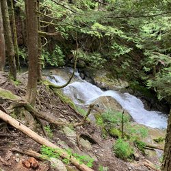
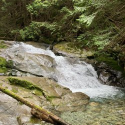
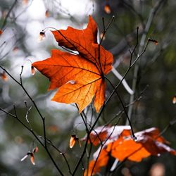
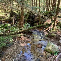
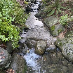
One fo several mountains on the North Shore. This one is just E of Grouse Mountain. To be honest Im not sure if there's an official parking lot per se. Basically head N in the direction of the mountain and eventually you'll pass by some rich people's houses and then there will be a stretch of road with free parking. Prospect Road and Skyline Drive come to mind. There are several hking trails that crisscross the forest. They seem to be fairly well maintained. There are also some random landmarks, such as bridge over a creek, and some waterfalls. One of the best ways to experience a West Coast forest for free, and way less packed than the other more famous local mountains. I didn't see anyone else the entire time my group was here. read more


Great for mountain bikers ok for hiking as many trails share the road. Wonderful coverage during the rain or hot season though. There are many trails you can get lost in. Value 4/5 Atmosphere 4/5 Service 3/5 limited parking Quality 3/5 14/20 read more


6 years ago
More info about Mount Fromme
Mount Fromme
North Vancouver, BC V7K 1X8
Canada
Directions
Hours
Outdoor Amenities


Mount Fromme - hiking - Updated July 2026
People found Mount Fromme by searching for…
Hiking Trails With Waterfalls in North Vancouver, British Columbia
Off Road Trails in North Vancouver, British Columbia
Secret Spots in North Vancouver, British Columbia
Off Leash Dog Hikes in North Vancouver, British Columbia
Free Parking in North Vancouver, British Columbia
Mountain Bike Trails in North Vancouver, British Columbia
Secluded Spots in North Vancouver, British Columbia
Scenic Views in North Vancouver, British Columbia
Walking Trails in North Vancouver, British Columbia
Tourist Attractions in North Vancouver, British Columbia
Waterfalls and Swimming Holes in North Vancouver, British Columbia
Waterfalls in North Vancouver, British Columbia
Gold Panning in North Vancouver, British Columbia
Redwood Forest in North Vancouver, British Columbia
Running Trails in North Vancouver, British Columbia
Night Walk in North Vancouver, British Columbia
Forest in North Vancouver, British Columbia
Hiking Groups in North Vancouver, British Columbia
Night Hiking in North Vancouver, British Columbia
Bridge in North Vancouver, British Columbia
Pump Track in North Vancouver, British Columbia
Fun Things to Do in North Vancouver, British Columbia
Browse Articles
Browse Brands
Related Searches in North Vancouver, BC
Affordable Bike Repair Services in North Vancouver, British Columbia
Affordable Bike Tune Up Services in North Vancouver, British Columbia
Affordable Kayak Rental Services in North Vancouver, British Columbia
Affordable Tandem Bike Rental in North Vancouver, British Columbia
Best Electric Bike Rental Services in North Vancouver, British Columbia
Best Fishing Locations and Guides in North Vancouver, British Columbia
Best Lookout Points to Visit in North Vancouver, British Columbia
Best Places for Horseback Riding in North Vancouver, British Columbia
Best Sledding Spots and Fun in North Vancouver, British Columbia
Best Waterfalls and Swimming Holes in North Vancouver, British Columbia
Check Out Off Road Trails in North Vancouver, British Columbia
Discover Popular Bike Tours in North Vancouver, British Columbia
Discover Scenic Mountain Bike Trails Near North Vancouver, British Columbia
Discover Scenic Waterfall Spots in North Vancouver, British Columbia
Discover the Best Night Hike Trails in North Vancouver, British Columbia
Discover the Best Running Track in North Vancouver, British Columbia
Discover the Best Snow Park Activities in North Vancouver, British Columbia
Enjoy Biking Adventures Around North Vancouver, British Columbia
Enjoy Camping Adventures Around North Vancouver, British Columbia
Enjoy Exciting Mountain Biking Adventures in North Vancouver, British Columbia
Enjoy Hiking Adventures in North Vancouver, British Columbia
Enjoy Kayaking Adventures in North Vancouver, British Columbia
Enjoy Scenic Night View Experiences in North Vancouver, British Columbia
Enjoy Tent Camping Spots Around North Vancouver, British Columbia
Enjoy Water Activities and Fun in North Vancouver, British Columbia
Enjoy the Best Family Activities in North Vancouver, British Columbia
Enjoy the Best Picnic Spots and Ideas in North Vancouver, British Columbia
Enjoy the Best Walking Trails in North Vancouver, British Columbia
Exciting Cliff Jumping Spots in North Vancouver, British Columbia
Experience Thrilling White Water Rafting in North Vancouver, British Columbia
Explore BMX Bike Shops Near North Vancouver, British Columbia
Explore Beautiful Parks and Green Spaces in North Vancouver, British Columbia
Explore Bike Rentals Throughout North Vancouver, British Columbia
Explore Electric Bikes Available in North Vancouver, British Columbia
Explore Free Things to Do Around North Vancouver, British Columbia
Explore Fun Activities to Do in North Vancouver, British Columbia
Explore Nature Spots Around North Vancouver, British Columbia
Explore Popular Campgrounds Near North Vancouver, British Columbia
Explore Popular View Points Around North Vancouver, British Columbia
Explore Scenic Lakes to Visit in North Vancouver, British Columbia
Explore Secret Spots Worth Visiting in North Vancouver, British Columbia
Explore the Best Beach Spots in North Vancouver, British Columbia
Explore the Best Boating Spots in North Vancouver, British Columbia
Explore the Best Trail Options in North Vancouver, British Columbia
Find Beautiful Views in North Vancouver, British Columbia
Find Parks and Recreation Activities in North Vancouver, British Columbia
Find Top-Rated Waterfalls in North Vancouver, British Columbia Now
Find a Fixed Gear Bike Shop in North Vancouver, British Columbia
Find the Best Bikes Available in North Vancouver, British Columbia
Find the Best Playgrounds to Visit in North Vancouver, British Columbia