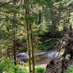
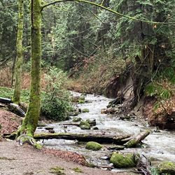
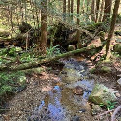
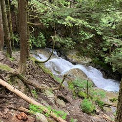
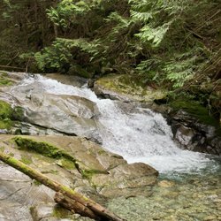
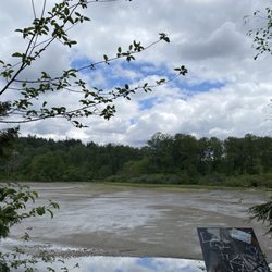
Burnaby Mountain Trail Photos


More like Burnaby Mountain Trail
Recommended Reviews - Burnaby Mountain Trail
Start your review...

Reviews With Photos - Burnaby Mountain Trail

On Saturday, a couple of friends and I went hiking on Burnaby Mountain. Home to Simon Fraser University, Burnaby Mountain has several hiking trails of various difficulty levels, and we spent a couple of hours hiking through the woods, following portions of different trails. While the majority of our hike was fairly easy, there were portions that definitely elevated our heart rate, including a brief, but intense hill. A good hike for someone building up their endurance and fitness level. The scenery was beautiful, and being somewhat transit accessible, I'm a fan. However, the majority (or possibly, all) of the trails are dual use, for both hikers and mountain bikers, who do not yield to hikers or even announce their presence -- you have to be careful and ready to suddenly jump out of the way to avoid a collision with a mountain biker zooming downhill around a bend without any warning. Several times we encountered mountain bikers who seemed to come out of nowhere, which was quite frightening. For this reason, I'm giving Burnaby Mountain three stars. Other things to note: the trails were quite muddy in spots, and while there was a outhouse along one of the paths we hiked, it was pretty disgusting, and the hand sanitizer dispenser was empty. Clearly the outhouse had not been cleaned and stocked for quite some time. Another annoying thing: We encountered a group/family of about 7 people stopped in a clearing, chatting and drinking Tim Hortons coffee. (Who the fuck drinks coffee on a hike?) Just as the three of us were about to pass them, instead of allowing us to pass, half of the group cut in front of us and proceeded to "walk" slooooowly, while the other half of the group came behind us, sandwiching us in between their group. So fucking rude! Not wanting to spend the next half an hour stuck less than 2 meters between a large crowd, we ended up staying in the clearing for a good 15 minutes to lose them. Ugh. In summary: great hike with beautiful scenery, but beware of dangerous mountain bikers and rude people. [Yelp collections: Hiking; Psycho cyclists]

We wanted to start hiking from Bernett hyw side but the City of Burnaby closd the parking lot. (Temporary due to COVID-19) So we came to top of the mountain and headed to down and climbed up the trail. It's about 4km and 1h 20 min in woods and not bad for quick easy hike. The trail is quite narrow. Sometimes we have to stop let the other people pass. The public toilet is just under the restaurant and very clean. The trail sign is bit confusing. We got lost once but as it's short trail, it's ok to have extra walk.

Love the 500 stairs up Burnaby grind. First of all, if you're tired of walking single file on a hike with a billion strangers, this is a great hike for you . It's peaceful, it's easy / intermediate depending on your fitness level . The stairs are well marked from all the entrances. There are views to the city as well as deep cove from the trails. The best part is the top . Japanese totems ! It's gorgeous and extremely spacious with parking if you have elderly guests who just want to see the top minus the hike . There is also a restaurant (Horizons ) at the top which we have not attended. This is otherwise known as the Burnaby grind. It can be done in 45 minutes or two hours . Bikes, Dogs, kids, family friendly. Great pictures to be had as well as apparently according to a photographer we know, One of the best locations for sunset pictures. Enjoy ! Super clean so let's keep it that way.

Burnaby Mountain Trail is Burnaby's version of Vancouver's Grouse Grind for less active crowd. You can easily walk it and not feel like you're about to pass out near the end. I saw a deer, a coyote, and a rabbit in the first 10 minutes on the trail. Luckily, I didn't encounter any bears. The view of Burrard Inlet and Port Moody is amazing!!!

On my way to visit family I had a wacky thought, why not go for a little hike/walk. And I could think of no better place than here! Perhaps it was the fact that I was literally driving directly towards the mountain! I parked on the gravel area just before Horizons Restaurant, and decided that it would be great to walk down and run back up the little trail that bends to the left. A great little trail when you want a bit of exercise, some peace and quiet but don't want to have to travel too far. Round trip from trail start to finish was less than 30 minutes, but there's a much bigger network of trails along here, and when the mood strikes my stagnant toes, I'll be moving and shaking back up that mountain again!

The entrance is right at Ridgeview & Dalla-Tina, you can't miss it! Easy parking is a plus. I took the easy trail (to the left) to start because it looked prettier to me. It turned into an alleged "intermediate trail" (it was still easy to me) and then I came across the Velodrome trail which is advanced because it has 500+ stairs. It was a lot of fun, very scenic and not too muddy despite yesterday's rain. The advanced trail says no dogs, but dogs can totally handle it. I got a good workout from this trail and enjoyed the fresh air and beautiful views that came with it!
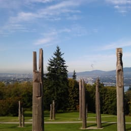
Definitely glad I went here. I didn't go on the hikes so I can only attest to the area near the parking lot. The view is great on clear days. Very serene and a great place to be if you want to be alone or clear your thoughts. The totem poles give it more historic value. The flower garden give the place more color contrast to the trees and water. I wouldn't be surprised if people took engagement or wedding pictures here. There is a restaurant here but I don't know the hours. And an added perk: free parking. Not as great as the view from Cypress Mountain, but I would definitely come back again.


Nothing beats this in person sun set view in Vancouver. Been here plenty of times and almost tread all different trails leading to burnaby mountain. From easy to hard, woody to gravel and stairs to incline climb , you find all sort of trails here. Big seating area on the grass and on some benches to enjoy the downtown view and sunset view from this place . Its not the highest mountain but at such a height that it gives good view of beautiful Vancouver. Mesmerizing feeling no matter when and how many times you come here. I personally like when its not crowded with people but you do get lots of student, visitors n other nature lovers on certain occasions like evenings. Especially closer to sunset so make sure to come little earlier ro get a good spot on the grass. Though all mountain gives amazing view. read more


2 years ago
Trail Series, Part 26 The Burnaby Mountain Trail has made me begin to wonder if I am developing a serious dependence on the British Columbia trail system. You see it doesn't seem to matter how many of them I run, I only seem to long for more. This location features a series of interconnected trails that are mostly technical in nature. I believe they can best be described as mountain bike trails that you are allowed to run or hike on. There are multiple bike jumps to navigate, numerous bridges to cross, frequent rocks and roots to avoid, and the downhills are fairly steep. Strollers and wheelchairs are not recommended and those with mobility issues would likely prefer to avoid this venue. Although you'll be surrounded by a dense blanket of trees, the trail offers occasional glimpses of some of the high rises in the greater Vancouver area. I found ample available parking on the adjacent Simon Fraser University campus for a nominal fee. If you're ready for a technical run (or ride), this place is for you. And that's...Henry's Take. #vancouvertrails read more


6 years ago
On Saturday, a couple of friends and I went hiking on Burnaby Mountain. Home to Simon Fraser University, Burnaby Mountain has several hiking trails of various difficulty levels, and we spent a couple of hours hiking through the woods, following portions of different trails. While the majority of our hike was fairly easy, there were portions that definitely elevated our heart rate, including a brief, but intense hill. A good hike for someone building up their endurance and fitness level. The scenery was beautiful, and being somewhat transit accessible, I'm a fan. However, the majority (or possibly, all) of the trails are dual use, for both hikers and mountain bikers, who do not yield to hikers or even announce their presence -- you have to be careful and ready to suddenly jump out of the way to avoid a collision with a mountain biker zooming downhill around a bend without any warning. Several times we encountered mountain bikers who seemed to come out of nowhere, which was quite frightening. For this reason, I'm giving Burnaby Mountain three stars. Other things to note: the trails were quite muddy in spots, and while there was a outhouse along one of the paths we hiked, it was pretty disgusting, and the hand sanitizer dispenser was empty. Clearly the outhouse had not been cleaned and stocked for quite some time. Another annoying thing: We encountered a group/family of about 7 people stopped in a clearing, chatting and drinking Tim Hortons coffee. (Who the fuck drinks coffee on a hike?) Just as the three of us were about to pass them, instead of allowing us to pass, half of the group cut in front of us and proceeded to "walk" slooooowly, while the other half of the group came behind us, sandwiching us in between their group. So fucking rude! Not wanting to spend the next half an hour stuck less than 2 meters between a large crowd, we ended up staying in the clearing for a good 15 minutes to lose them. Ugh. In summary: great hike with beautiful scenery, but beware of dangerous mountain bikers and rude people. [Yelp collections: Hiking; Psycho cyclists] read more


We wanted to start hiking from Bernett hyw side but the City of Burnaby closd the parking lot. (Temporary due to COVID-19) So we came to top of the mountain and headed to down and climbed up the trail. It's about 4km and 1h 20 min in woods and not bad for quick easy hike. The trail is quite narrow. Sometimes we have to stop let the other people pass. The public toilet is just under the restaurant and very clean. The trail sign is bit confusing. We got lost once but as it's short trail, it's ok to have extra walk. read more


8 years ago
Love the 500 stairs up Burnaby grind. First of all, if you're tired of walking single file on a hike with a billion strangers, this is a great hike for you . It's peaceful, it's easy / intermediate depending on your fitness level . The stairs are well marked from all the entrances. There are views to the city as well as deep cove from the trails. The best part is the top . Japanese totems ! It's gorgeous and extremely spacious with parking if you have elderly guests who just want to see the top minus the hike . There is also a restaurant (Horizons ) at the top which we have not attended. This is otherwise known as the Burnaby grind. It can be done in 45 minutes or two hours . Bikes, Dogs, kids, family friendly. Great pictures to be had as well as apparently according to a photographer we know, One of the best locations for sunset pictures. Enjoy ! Super clean so let's keep it that way. read more


Burnaby Mountain Trail is Burnaby's version of Vancouver's Grouse Grind for less active crowd. You can easily walk it and not feel like you're about to pass out near the end. I saw a deer, a coyote, and a rabbit in the first 10 minutes on the trail. Luckily, I didn't encounter any bears. The view of Burrard Inlet and Port Moody is amazing!!! read more

17 years ago
On my way to visit family I had a wacky thought, why not go for a little hike/walk. And I could think of no better place than here! Perhaps it was the fact that I was literally driving directly towards the mountain! I parked on the gravel area just before Horizons Restaurant, and decided that it would be great to walk down and run back up the little trail that bends to the left. A great little trail when you want a bit of exercise, some peace and quiet but don't want to have to travel too far. Round trip from trail start to finish was less than 30 minutes, but there's a much bigger network of trails along here, and when the mood strikes my stagnant toes, I'll be moving and shaking back up that mountain again! read more


The entrance is right at Ridgeview & Dalla-Tina, you can't miss it! Easy parking is a plus. I took the easy trail (to the left) to start because it looked prettier to me. It turned into an alleged "intermediate trail" (it was still easy to me) and then I came across the Velodrome trail which is advanced because it has 500+ stairs. It was a lot of fun, very scenic and not too muddy despite yesterday's rain. The advanced trail says no dogs, but dogs can totally handle it. I got a good workout from this trail and enjoyed the fresh air and beautiful views that came with it! read more


 - Hiking Near Me - Burnaby, British Columbia")


13 years ago
Definitely glad I went here. I didn't go on the hikes so I can only attest to the area near the parking lot. The view is great on clear days. Very serene and a great place to be if you want to be alone or clear your thoughts. The totem poles give it more historic value. The flower garden give the place more color contrast to the trees and water. I wouldn't be surprised if people took engagement or wedding pictures here. There is a restaurant here but I don't know the hours. And an added perk: free parking. Not as great as the view from Cypress Mountain, but I would definitely come back again. read more


12 years ago
Love it love it love it! I always come here to mountain bike, I'm never disappointed. Fresh air, awesome trails, what else could you ask for? read more


6 years ago
17 years ago
11 years ago
Wow this trail kicked my butt today, probably not as hard as the chief or the grouse grind but nonetheless it still whooped my butt. I will be thanking it for toning my rear end and legs and getting my cardio in. When I think of Burnaby mountain I thought it'd be a walk in the park like central park but longer boy was I wrong. What should've been a 3 hour hike turned into 2 and a half hours because we went late in the day and the sun was starting to set. The trails here were mostly gravel tons of steep uphill and downhill. Its a great workout but it didn't have the magnificent views some of the other hiking trails provided. What's really great about this trail are the people. So many hikers and bikers we encountered were some of the friendliest people I've ever met. When passing by them they would say hello which was awesome. After finishing the hike I've never been so happy to see flat land again! read more


15 years ago
More info about Burnaby Mountain Trail
Review Highlights - Burnaby Mountain Trail


Burnaby Mountain Trail - hiking - Updated July 2026
People found Burnaby Mountain Trail by searching for…
Places to Take Pictures in Burnaby, British Columbia
Parks in Burnaby, British Columbia
Playgrounds in Burnaby, British Columbia
Secret Spots in Burnaby, British Columbia
Views in Burnaby, British Columbia
Watch Sunset in Burnaby, British Columbia
Hiking Trails in Burnaby, British Columbia
Scenic Drive in Burnaby, British Columbia
Scenic View in Burnaby, British Columbia
Stair Climbing in Burnaby, British Columbia
Stairs Workout in Burnaby, British Columbia
Secluded Spots in Burnaby, British Columbia
Running Trails in Burnaby, British Columbia
Free Parking in Burnaby, British Columbia
Walking Trail in Burnaby, British Columbia
Sunset in Burnaby, British Columbia
Blackberry Picking in Burnaby, British Columbia
Off Leash Dog Hikes in Burnaby, British Columbia
Sunset View in Burnaby, British Columbia
Dog Friendly Hiking Trails in Burnaby, British Columbia
Mountain Biking in Burnaby, British Columbia
Running Stairs in Burnaby, British Columbia
Browse Articles
Browse Brands
Related Searches in Burnaby, BC
Affordable Kayak Rental Services in Burnaby, British Columbia
Best Fishing Locations and Guides in Burnaby, British Columbia
Best Places for Horseback Riding in Burnaby, British Columbia
Check Out Off Road Trails in Burnaby, British Columbia
Discover Scenic Mountain Bike Trails Near Burnaby, British Columbia
Discover Scenic Waterfall Spots in Burnaby, British Columbia
Discover the Best Night Hike Trails in Burnaby, British Columbia
Discover the Best Running Track in Burnaby, British Columbia
Enjoy Camping Adventures Around Burnaby, British Columbia
Enjoy Exciting Mountain Biking Adventures in Burnaby, British Columbia
Enjoy Kayaking Adventures in Burnaby, British Columbia
Enjoy Tent Camping Spots Around Burnaby, British Columbia
Enjoy Water Activities and Fun in Burnaby, British Columbia
Enjoy the Best Family Activities in Burnaby, British Columbia
Enjoy the Best Walking Trails in Burnaby, British Columbia
Exciting Cliff Jumping Spots in Burnaby, British Columbia
Experience Thrilling White Water Rafting in Burnaby, British Columbia
Explore Beautiful Parks and Green Spaces in Burnaby, British Columbia
Explore Free Things to Do Around Burnaby, British Columbia
Explore Fun Activities to Do in Burnaby, British Columbia
Explore Nature Spots Around Burnaby, British Columbia
Explore Popular Campgrounds Near Burnaby, British Columbia
Explore Scenic Lakes to Visit in Burnaby, British Columbia
Explore the Best Beach Spots in Burnaby, British Columbia
Explore the Best Boating Spots in Burnaby, British Columbia
Explore the Best Trail Options in Burnaby, British Columbia
Find Beautiful Views in Burnaby, British Columbia
Find Parks and Recreation Activities in Burnaby, British Columbia
Find Popular Ziplining Spots Around Burnaby, British Columbia
Find the Best Playgrounds to Visit in Burnaby, British Columbia
Find the Best Scenic View Locations in Burnaby, British Columbia
Hiking Trails With Waterfalls in Burnaby, British Columbia
Plan a Scenic Drive Route Near Burnaby, British Columbia
Popular Fishing Spots to Explore in Burnaby, British Columbia
Popular Outdoor Activities to Try in Burnaby, British Columbia
Popular Picnic Spots to Visit in Burnaby, British Columbia
Popular Things to Do in Burnaby, British Columbia
Popular Things to See in Burnaby, British Columbia
Safe River Swimming Areas in Burnaby, British Columbia
Safe and Fun Parks for Kids in Burnaby, British Columbia
Top Climbing Spots and Gyms in Burnaby, British Columbia
Top Places for Snorkeling in Burnaby, British Columbia
Top Places to Visit in Burnaby, British Columbia for Sightseeing
Top Playgrounds for Kids to Enjoy in Burnaby, British Columbia
Top Running Trails to Explore in Burnaby, British Columbia
Top Swimming Lakes to Enjoy in Burnaby, British Columbia
Top Swimming Spots and Pools in Burnaby, British Columbia
Top Things to Do With Kids in Burnaby, British Columbia
Walk Dog Friendly Hiking Trails in Burnaby, British Columbia
Walk the Best Paved Walking Trails in Burnaby, British Columbia
People who viewed Burnaby Mountain Trail also viewed
Lynn Headwaters Regional Park
22 reviews
Varley Trail
1 review
Lynn Valley
Minnekhada Regional Park
7 reviews
Mount Seymour Provincial Park
14 reviews
Capilano River Regional Park
10 reviews
Fraser Foreshore Park
16 reviews
Arbutus Greenway
4 reviews
Arbutus Ridge
Robert Burnaby Park
8 reviews
Pinecone Burke Provincial Park
2 reviews
Horseshoe Bay Park
6 reviews
Ambleside