Quarry Rock Photos


More like Quarry Rock
Recommended Reviews - Quarry Rock
Start your review...

Reviews With Photos

We found the trail to hike in along the pathway on the main road. I am in my 40s so i didn't think it was a super easy hike. I think its more of a strenuous hike with a lot of people. Going up/there are inclines and coming down, i fell a few times. There are tree markers in case you need to call 911. It took us about 1 hr 20 minutes to hike in, about the same time or less to hike out. We parked by a park as local street parking is limited/blocked.

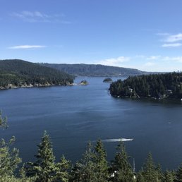
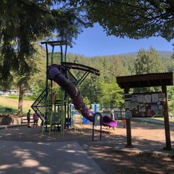
Nice easyish hike which is great for tourists. This hike is a great test to see if someone is ready for something like the Grouse Grind. Parking is available at the nearby Panorama Park lot. I've been told this lot fills up very early in the morning during the summer. I was there by 0730 and the lot was already mostly full. Once the lot fills up, there is literally no more parking in the vicinity, which may put a huge dent in one's day. I'm not even sure if the nearby village area has any public parking. As for the hike, it's nothing super crazy. The net elevation gain is some 100m, and there are plenty of nicely made stairs. They say the hike can be done in 1h or so each direction. At the rock itself there is a survey marker. From here, one can see clear views from Belcarra all the way to Capitol Hill (Burnaby), which is almost 180 degrees. Definitely worth doing at least once.

I understand the parking is challenging. But I didn't know the downtown, literally main street of Deep Cove have construction and the traffic was different and limited in May 2023. I found alternate trailhead to Quarry Rock and we parked on a spot without restriction sign. It was lucky. This trail is getting popular for new hikers or kids, or dog walker. Be aware those dogs are off leash. When you get to Quarry Rock, you will have pleasant view and breezes. However on the way there, there was almost no breeze. Don't forget to bring water bottle.

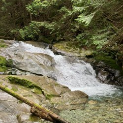
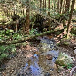
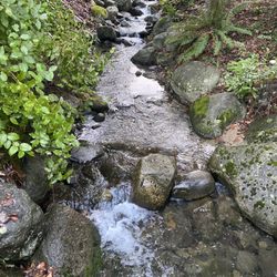
Quarry Rock, located in Deep Cove in North Vancouver, is an extremely popular local hiking trail. It's part of the Baden Powell Trail, and at 3.8km round trip with an elevation gain of 100 meters, it doesn't take more than about 45 minutes each way. There are stairs and tree roots to scramble over, but it's one of the easier hikes, and it's perfect for a beginner, or casual hiker. As you hike to the top, you'll pass over some wooden bridges and pass a few small waterfalls. At the top, there is a large rock where one can sit down, have a snack, and enjoy the spectacular view. I first went to Quarry Rock in 2013, and despite loving the hike, I've only gone a handful of time over the years due to the difficulty in getting there via transit*. I went there on Friday evening with friends, the first time in a couple of years, and we were fortunate that we found parking. It was a great hike, and I do hope to go more often. *Because Deep Cove is such a popular spot, finding parking can be nearly impossible. And while Deep Cove and Quarry Rock are *technically* transit accessible (ie. there are a couple of buses, the #211 and #212, that go to Deep Cove), the buses only run every half a hour, and it's a long transit ride (an hour, depending on where you're departing from). [Yelp collections: Hiking]

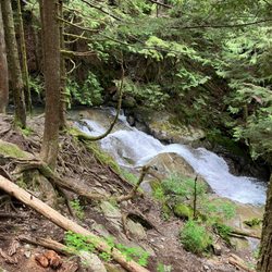
Quarry Rock has a beautiful view! It was quite crowded when I arrived, so I didn't get to enjoy it as much as I might've. But I still appreciated the view from a distance! There's another rock not far from Quarry off a little trail and my friend and I had it to ourselves. Not quite as good of a view, but I preferred the serenity of it to Quarry Rock itself. The trail to get there is a bit tough. There are a bunch of stairs -- like a LOT of stairs -- and rocky ground and tree roots that jut up from the dirt. So you really need proper shoes and to pay attention to where you're walking. I heard from several people that the trail only takes 30 minutes. Having done the trail for the first time, I laugh at that. Maybe for experienced hikers, those used to elevation and/or those who know the trail... for those of you visiting from flat lands like me, it may take longer. I think my friend and I were on the 2ish mile (round trip) trail for about two hours in total. Granted, some of that time was hiking, some admiring the water cascading down the hills, some was catching our breath, and some of the time was spent admiring the views. I felt really accomplished after making my way to Quarry Rock! It was fun, but challenging, and the views were lovely. Worth going, so long as your body is able to handle inclines and a plethora of stairs.

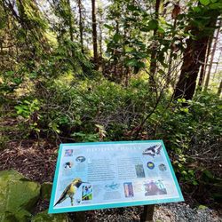
[posting as a recent tourist] I came here alone during my recent Vancouver trip. I wanted to squeeze in a doable hike as a solo traveler with no gear and still be safe while doing so. Due to transportation limitations (I had no car) and weather transitioning from winter-spring, there weren't many options accessible from Downtown Vancouver. I took two buses (the 210 and 212) to get here (~1 hour one way). You transfer at the Phibbs Exchange, which was super easy. If traveling before 5P, you can take the 211, which requires no transfer. Upside: no need to worry about parking! I came towards later afternoon, around 4PM. The hike itself was very tame, ~3.8km roundtrip from the trailhead, perfect for casual hikers and beginners. The trailhead was easy to find and nestled by some residential homes. You can consult the sign at the park for more directions. The path itself was very clearly marked with bright orange cards/tape that you cannot miss. It was helpful that I saw people coming back down, so I knew I was going in the right direction. The trail was a good mix of man-made steps and gravel/roots/branches/trees. Elevation gain was not significant and quite doable. Not much a view until you get to the very end at Quarry Rock- a small slab of granite that offers some sitting, rest, and stunning photo opportunities of the view below. If feeling adventurous, the Baden-Powell trail continues, so I went a bit extra for a 5K roundtrip.The entire roundtrip including stops for photos took me approx 55 minutes. I also wore regular running shoes, which turned out to be appropriate. I felt safe while doing this hike, which was a huge plus. Would definitely recommend for those in Vancouver wishing to do a light, easy hike and have limited access to transportation and other hiking trails.
Ever thought you were going to die, but didn't? We hiked thru Capilano Suspension bridge, Lynn Canyon Suspension bridge, and just for fun headed up Quarry Rock all in the same day... I asked this young man working the boats in the bay about the hike to the Quarry Rock I could see sticking out near the mouth of the bay. He said "it's pretty easy, up some steps then walk along the ridge, about 30-40 minutes". Well, maybe he is in Olympic shape, cause man, that was no 30-40 minutes... It was over 200 steps up, then up and down as you went across the ridge dodging roots. over an hour later we hit the clearing and WHAT A VIEW! second to none. It was well worth the trip to the top, even if I was sore for 3 more days.... You can do this justice with pictures, you have to experience it. don't miss this hike if you visit Canada!

Great hike and great view at the top! -off leash dog friendly -well marked trail -starts in Deep Cove Panorama Dr (literally someones drive way, look for signs) -easy to moderate level (some ups, some downs, stairs) - a section of Baden Powell trail - gets pretty busy during the weekend parking can be hard

Breathtaking!! Every on a foggy day, the view is just amazing. Even if the hike was twice as lengthy and twice as difficult, it would still be 100% worth it to get to Quarry Rock. We stayed at the viewpoint so long because we didn't want to leave! It's such a good spot for pictures. Please be courteous to others because when we were there, a couple people sat at the key photo op spot for 30+ mins.

I didn't have time to travel to far away from Vancouver but still wanted to squeeze in a quick hike. Quarry Rock was just a half hour or so away and had everything i was looking for: a parking lot, paved trail, great view. I thought it'd be majority uphill but there were plenty of dips, curves, and some stairs which made it much more fun. There were some crowds so we sped up our usual pace when the path was clear and ended up getting a great HIIT workout in. If you workout regularly this is a fairly easy 2.3 mile round trip hike. It seems great for families too. You'll want to take some pictures at the top. Just know you may have to wait your turn! If you're feeling adventurous, there's another large rock face you can climb just nearby towards the tower featuring more views and a random hammock. Note: a little construction going on as they build out more steps.

I second the comment "did you ever think you were going to die but didn't?!". This hike has ALOT of stairs which I wasn't prepared for so for me it was pretty hard. My fitness app said 58 flights of stairs - up and down and up and down and through some rocks and roots but the teenagers and the fit were fine. They said it was easy for them and they could have ran it. I guess it all depends on your fitness level. The view is gorgeous and a great spot for a break. The village of Deep Cove is idyllic and quant and just beautiful. Parking is a nightmare so bring your patience. We went on a beautiful Sunday in June and it was PACKED with people everywhere which was fine as we were prepared for the crowds. All in all, I am sore and may not be able to walk tomorrow the teenagers rate is a 6 out of 10 in difficulty.

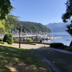
Ahhhh The Cove! On a hot summer day, there is something to be said about driving or transiting away from the chaos of downtown Vancouver over to Deep Cove. Where a quiet, peaceful little town awaits your presence. One of the highlights is the Quarry Rock hike. An easy 3.8km return hike through the dense North Van forest to one of the best lookouts that isn't on top of a mountain. Parking is a breeze down by the marina and then it is a short walk along Panorama Drive to the Trailhead sign. It seems like you may be walking into someones backyard, but the initial steep ascent lets you know that you are indeed hiking in the woods! A few tips... Bring lots of water and pack a proper lunch as it is very easy to laze around and bake on "the rock". And most of all stick to the trail. I tried to be a hero and cut down towards the water on my return, thinking "there must be a trail down there to the ocean". Not so much! It's like a Boreal jungle trek without the machete and guide. And if it is a sticky summer day, a plunge into the Cove or a visit to the ice cream place upon your return is the perfect finale to the hike. Or do both!

This trail is rated easy, however not for the average person. It takes about 1.5 hours round trip for an average person. However, if you play sports and can run an easy 5-6 minute mile, it is quite easy. Parking is very hard and I parked half a mile away on a Friday afternoon. The trail is very crowded but the view is beautiful. read more

Quarry Rock was beautiful and a nice trail for tourists looking to enjoy some scenic nature views. I would describe this hike as an easy hike but with a larger incline during the beginning and end of the trail. Parking is available at Panorama Park but fills up quickly. Plan to add another 20-30 minutes wait time to your travels if you're packing a tight schedule. Another thing to note is that Google shows a trail leading from the main vantage point back down to the water; but it has since been removed as a path as there were signs and tape that indicated 'no trespassing'. This means that we took the same trail there and back, adding another 45-60 minutes to our itinerary. All in all, you don't want to miss the stunning views. The photos don't do the views at this vantage point justice. read more


This hike is easy. If you're in good shape! Lol! For beginners? No! Its intermediate at least, depending on how fit you are. I'm out of shape and this is my first effort trying to get back into a healthy lifestyle. To be fair, you'll see 5 yr olds do it, with their parents, older people in their 60's, perhaps older, and anyone in between. For some, it looks effortless but you see people catching their breath as well. Everyone you encounter on the trail was nice! I was told by one lady with her dog the first 10 mins is the hardest, but for an out of shape guy like me ie. I take walks but not serious hikes, it was a challenge all the way up. I used to do mountain biking about 5 yrs ago. Looking to get back into shape. Would I start here if I knew the steep stair climbs up and down, no! Am I glad I did it? Yes! A couple of Rocky, Top Gun, and Karate Kid soundtracks in my playlist helped me push through. I'm going to have a good sleep tonight! I posted pics of some of the stairs so you will know how steep the climb is. You will encounter a lot of rocks and tree roots along the way so a good hiking shoe is recommended. I had a thin soled running shoe and felt every rock under my feet. Bring water! It helps keep you hydrated to keep you going! On your way to Quarry Rock, once you are in Deep Cove (the town) and on Panorama Dr, the online map will lead you all the way to a deadend. On Panorama Dr, when you see Panorama Park on your right, start looking for a crosswalk going to Baden Powell Trail. It's on your left, just after the park. Parking is a challenge if you are not there early. There's plenty of paid parking lots. Around the area you can find free street parking for 3hrs. I heard they are strict in enforcing this time frame. It took me 45 mins one way so about 1.5 hrs round trip. Rested up there with plenty of time to spare to quickly look around town, barely. It's touristy so by the time I'm back down, there's plenty of people looking for parking. It's a good experience overall. The view is worth the climb! I just wanted to paint a picture of what to expect! Enjoy! read more


3 months ago
11 months ago
We found the trail to hike in along the pathway on the main road. I am in my 40s so i didn't think it was a super easy hike. I think its more of a strenuous hike with a lot of people. Going up/there are inclines and coming down, i fell a few times. There are tree markers in case you need to call 911. It took us about 1 hr 20 minutes to hike in, about the same time or less to hike out. We parked by a park as local street parking is limited/blocked. read more


Nice easyish hike which is great for tourists. This hike is a great test to see if someone is ready for something like the Grouse Grind. Parking is available at the nearby Panorama Park lot. I've been told this lot fills up very early in the morning during the summer. I was there by 0730 and the lot was already mostly full. Once the lot fills up, there is literally no more parking in the vicinity, which may put a huge dent in one's day. I'm not even sure if the nearby village area has any public parking. As for the hike, it's nothing super crazy. The net elevation gain is some 100m, and there are plenty of nicely made stairs. They say the hike can be done in 1h or so each direction. At the rock itself there is a survey marker. From here, one can see clear views from Belcarra all the way to Capitol Hill (Burnaby), which is almost 180 degrees. Definitely worth doing at least once. read more


 - Hiking Near Me - North Vancouver, British Columbia")
 - Hiking Near Me - North Vancouver, British Columbia")
 - Hiking Near Me - North Vancouver, British Columbia")
 - Hiking Near Me - North Vancouver, British Columbia")
I understand the parking is challenging. But I didn't know the downtown, literally main street of Deep Cove have construction and the traffic was different and limited in May 2023. I found alternate trailhead to Quarry Rock and we parked on a spot without restriction sign. It was lucky. This trail is getting popular for new hikers or kids, or dog walker. Be aware those dogs are off leash. When you get to Quarry Rock, you will have pleasant view and breezes. However on the way there, there was almost no breeze. Don't forget to bring water bottle. read more


7 years ago
Quarry Rock, located in Deep Cove in North Vancouver, is an extremely popular local hiking trail. It's part of the Baden Powell Trail, and at 3.8km round trip with an elevation gain of 100 meters, it doesn't take more than about 45 minutes each way. There are stairs and tree roots to scramble over, but it's one of the easier hikes, and it's perfect for a beginner, or casual hiker. As you hike to the top, you'll pass over some wooden bridges and pass a few small waterfalls. At the top, there is a large rock where one can sit down, have a snack, and enjoy the spectacular view. I first went to Quarry Rock in 2013, and despite loving the hike, I've only gone a handful of time over the years due to the difficulty in getting there via transit*. I went there on Friday evening with friends, the first time in a couple of years, and we were fortunate that we found parking. It was a great hike, and I do hope to go more often. *Because Deep Cove is such a popular spot, finding parking can be nearly impossible. And while Deep Cove and Quarry Rock are *technically* transit accessible (ie. there are a couple of buses, the #211 and #212, that go to Deep Cove), the buses only run every half a hour, and it's a long transit ride (an hour, depending on where you're departing from). [Yelp collections: Hiking] read more


7 years ago
Quarry Rock has a beautiful view! It was quite crowded when I arrived, so I didn't get to enjoy it as much as I might've. But I still appreciated the view from a distance! There's another rock not far from Quarry off a little trail and my friend and I had it to ourselves. Not quite as good of a view, but I preferred the serenity of it to Quarry Rock itself. The trail to get there is a bit tough. There are a bunch of stairs -- like a LOT of stairs -- and rocky ground and tree roots that jut up from the dirt. So you really need proper shoes and to pay attention to where you're walking. I heard from several people that the trail only takes 30 minutes. Having done the trail for the first time, I laugh at that. Maybe for experienced hikers, those used to elevation and/or those who know the trail... for those of you visiting from flat lands like me, it may take longer. I think my friend and I were on the 2ish mile (round trip) trail for about two hours in total. Granted, some of that time was hiking, some admiring the water cascading down the hills, some was catching our breath, and some of the time was spent admiring the views. I felt really accomplished after making my way to Quarry Rock! It was fun, but challenging, and the views were lovely. Worth going, so long as your body is able to handle inclines and a plethora of stairs. read more


[posting as a recent tourist] I came here alone during my recent Vancouver trip. I wanted to squeeze in a doable hike as a solo traveler with no gear and still be safe while doing so. Due to transportation limitations (I had no car) and weather transitioning from winter-spring, there weren't many options accessible from Downtown Vancouver. I took two buses (the 210 and 212) to get here (~1 hour one way). You transfer at the Phibbs Exchange, which was super easy. If traveling before 5P, you can take the 211, which requires no transfer. Upside: no need to worry about parking! I came towards later afternoon, around 4PM. The hike itself was very tame, ~3.8km roundtrip from the trailhead, perfect for casual hikers and beginners. The trailhead was easy to find and nestled by some residential homes. You can consult the sign at the park for more directions. The path itself was very clearly marked with bright orange cards/tape that you cannot miss. It was helpful that I saw people coming back down, so I knew I was going in the right direction. The trail was a good mix of man-made steps and gravel/roots/branches/trees. Elevation gain was not significant and quite doable. Not much a view until you get to the very end at Quarry Rock- a small slab of granite that offers some sitting, rest, and stunning photo opportunities of the view below. If feeling adventurous, the Baden-Powell trail continues, so I went a bit extra for a 5K roundtrip.The entire roundtrip including stops for photos took me approx 55 minutes. I also wore regular running shoes, which turned out to be appropriate. I felt safe while doing this hike, which was a huge plus. Would definitely recommend for those in Vancouver wishing to do a light, easy hike and have limited access to transportation and other hiking trails. read more

9 years ago
Ever thought you were going to die, but didn't? We hiked thru Capilano Suspension bridge, Lynn Canyon Suspension bridge, and just for fun headed up Quarry Rock all in the same day... I asked this young man working the boats in the bay about the hike to the Quarry Rock I could see sticking out near the mouth of the bay. He said "it's pretty easy, up some steps then walk along the ridge, about 30-40 minutes". Well, maybe he is in Olympic shape, cause man, that was no 30-40 minutes... It was over 200 steps up, then up and down as you went across the ridge dodging roots. over an hour later we hit the clearing and WHAT A VIEW! second to none. It was well worth the trip to the top, even if I was sore for 3 more days.... You can do this justice with pictures, you have to experience it. don't miss this hike if you visit Canada! read more


Great hike and great view at the top! -off leash dog friendly -well marked trail -starts in Deep Cove Panorama Dr (literally someones drive way, look for signs) -easy to moderate level (some ups, some downs, stairs) - a section of Baden Powell trail - gets pretty busy during the weekend parking can be hard read more


8 years ago
Breathtaking!! Every on a foggy day, the view is just amazing. Even if the hike was twice as lengthy and twice as difficult, it would still be 100% worth it to get to Quarry Rock. We stayed at the viewpoint so long because we didn't want to leave! It's such a good spot for pictures. Please be courteous to others because when we were there, a couple people sat at the key photo op spot for 30+ mins. read more


9 years ago
I didn't have time to travel to far away from Vancouver but still wanted to squeeze in a quick hike. Quarry Rock was just a half hour or so away and had everything i was looking for: a parking lot, paved trail, great view. I thought it'd be majority uphill but there were plenty of dips, curves, and some stairs which made it much more fun. There were some crowds so we sped up our usual pace when the path was clear and ended up getting a great HIIT workout in. If you workout regularly this is a fairly easy 2.3 mile round trip hike. It seems great for families too. You'll want to take some pictures at the top. Just know you may have to wait your turn! If you're feeling adventurous, there's another large rock face you can climb just nearby towards the tower featuring more views and a random hammock. Note: a little construction going on as they build out more steps. read more

8 years ago
I second the comment "did you ever think you were going to die but didn't?!". This hike has ALOT of stairs which I wasn't prepared for so for me it was pretty hard. My fitness app said 58 flights of stairs - up and down and up and down and through some rocks and roots but the teenagers and the fit were fine. They said it was easy for them and they could have ran it. I guess it all depends on your fitness level. The view is gorgeous and a great spot for a break. The village of Deep Cove is idyllic and quant and just beautiful. Parking is a nightmare so bring your patience. We went on a beautiful Sunday in June and it was PACKED with people everywhere which was fine as we were prepared for the crowds. All in all, I am sore and may not be able to walk tomorrow the teenagers rate is a 6 out of 10 in difficulty. read more


7 years ago
Ahhhh The Cove! On a hot summer day, there is something to be said about driving or transiting away from the chaos of downtown Vancouver over to Deep Cove. Where a quiet, peaceful little town awaits your presence. One of the highlights is the Quarry Rock hike. An easy 3.8km return hike through the dense North Van forest to one of the best lookouts that isn't on top of a mountain. Parking is a breeze down by the marina and then it is a short walk along Panorama Drive to the Trailhead sign. It seems like you may be walking into someones backyard, but the initial steep ascent lets you know that you are indeed hiking in the woods! A few tips... Bring lots of water and pack a proper lunch as it is very easy to laze around and bake on "the rock". And most of all stick to the trail. I tried to be a hero and cut down towards the water on my return, thinking "there must be a trail down there to the ocean". Not so much! It's like a Boreal jungle trek without the machete and guide. And if it is a sticky summer day, a plunge into the Cove or a visit to the ice cream place upon your return is the perfect finale to the hike. Or do both! read more


6 years ago
Lovely hike . Super hard to find parking...but keep the faith ! If you want solitude this hike is not for you on the weekends . It's single file and you may have to listen to the people around you chatting. Once you're on the top however, it's majestic. Lots of angles and ways to see North Vancouver . I suggest kayaking the following day in deep cove and looking up to see Quarry Rock . Enjoy ! It's a classic hike and pretty average fitness level required. Great picture quality! Pro tip: Honeys donuts afterwards are a Deep Cove staple . The only thing busier than the peak of Quarry Rock is the donut joint after to negate all of your hard earned calories burned ! read more


Baden Powell deep cove quarry rock hike in North Vancouver Favourite quick hike near town and accessible by public transit It's about 1.5 hour round trip. We ended up catching the sunset this time!It's very busy and many dogs on trail. Although rated as easy, it has quiet the elevation and roots everywhere so have proper shoes I love the BP trails of Vancouver so well maintained- thank you volunteers and park rangers! Value 5/5Atmosphere 4/5Service 5/5Quality 5/5 19/20 read more


7 years ago
Amazing viewand worth the hike even though the place is small at the top!!! I loved this place read more


6 years ago
8 years ago
15 years ago
The lookout provides a great view of deep cove and Indian Arm. This is a great little hike for anyone in Vancouver who does not want to spend the whole day in the forest and is hiking more for pleasure than exercise. The lookout point can be seen from deep cove and the hike is easy compared to many on the north shore. Another great thing is that it is open all year. If you head to the hike on the weekend then it is a good idea to get there earlier because the parking lot and trail get busy. Other than that a great little hike, would recommend to anyone. read more


9 years ago
12 years ago
11 years ago
9 years ago
16 years ago
Page 1 of 2
More info about Quarry Rock
2400 Panorama Drive
North Vancouver, BC V7G 1V5
Canada
Deep Cove
Directions
Hours
Outdoor Amenities
Review Highlights - Quarry Rock


Why does Yelp recommend reviews?
Quarry Rock - hiking - Updated August 2026
People found Quarry Rock by searching for…
Beaches in North Vancouver, BC
Things to Do in North Vancouver, BC
Places to Take Pictures in North Vancouver, BC
Hiking Trails With Waterfalls in North Vancouver, BC
Dog Friendly Beaches in North Vancouver, BC
Scenic Drive in North Vancouver, BC
Scenic View in North Vancouver, BC
Watch Sunset in North Vancouver, BC
Hidden Picnic Spots in North Vancouver, BC
Secret Spots in North Vancouver, BC
Beautiful Views in North Vancouver, BC
Secluded Spots in North Vancouver, BC
Lookout Points in North Vancouver, BC
Off Leash Dog Hikes in North Vancouver, BC
Stairs Workout in North Vancouver, BC
Photo Spots in North Vancouver, BC
Hot Springs in North Vancouver, BC
Walking Trails in North Vancouver, BC
Boardwalk in North Vancouver, BC
Stair Climbing in North Vancouver, BC
View Points in North Vancouver, BC
Browse Articles
Browse Brands
Related Searches in North Vancouver, BC
Affordable Kayak Rental Services in North Vancouver, British Columbia
Best Fishing Locations and Guides in North Vancouver, British Columbia
Best Places for Horseback Riding in North Vancouver, British Columbia
Best Sightseeing Experiences Available in North Vancouver, British Columbia
Check Out Off Road Trails in North Vancouver, British Columbia
Discover Popular Bike Trails in North Vancouver, British Columbia
Discover Scenic Mountain Bike Trails Near North Vancouver, British Columbia
Discover the Best Beaches in North Vancouver, British Columbia
Discover the Best Night Hike Trails in North Vancouver, British Columbia
Enjoy Camping Adventures Around North Vancouver, British Columbia
Enjoy Exciting Mountain Biking Adventures in North Vancouver, British Columbia
Enjoy Kayaking Adventures in North Vancouver, British Columbia
Enjoy Off Leash Dog Hikes in North Vancouver, British Columbia
Enjoy Scenic Places to Walk in North Vancouver, British Columbia
Enjoy Tent Camping Spots Around North Vancouver, British Columbia
Enjoy Water Activities and Fun in North Vancouver, British Columbia
Enjoy the Best Walking Trails in North Vancouver, British Columbia
Experience Stunning Sunset Views in North Vancouver, British Columbia
Experience Thrilling White Water Rafting in North Vancouver, British Columbia
Explore Beautiful Parks and Green Spaces in North Vancouver, British Columbia
Explore Fun Activities to Do in North Vancouver, British Columbia
Explore Popular Campgrounds Near North Vancouver, British Columbia
Explore Popular Dog Walking Trails in North Vancouver, British Columbia
Explore Scenic Lakes to Visit in North Vancouver, British Columbia
Explore Top Dog Parks in North Vancouver, British Columbia Near You
Explore Top Water Parks in North Vancouver, British Columbia Today
Explore the Best Beach Spots in North Vancouver, British Columbia
Find Beautiful Views in North Vancouver, British Columbia
Find Parks and Recreation Activities in North Vancouver, British Columbia
Find Top-Rated Waterfalls in North Vancouver, British Columbia Now
Find the Best Playgrounds to Visit in North Vancouver, British Columbia
Hiking Trails With Waterfalls in North Vancouver, British Columbia
Plan a Scenic Drive Route Near North Vancouver, British Columbia
Popular Fishing Spots to Explore in North Vancouver, British Columbia
Popular Kids Activities in North Vancouver, British Columbia
Popular Outdoor Activities to Try in North Vancouver, British Columbia
Popular Picnic Spots to Visit in North Vancouver, British Columbia
Safe and Fun Parks for Kids in North Vancouver, British Columbia
Top Dog Friendly Things to Do in North Vancouver, British Columbia
Top Hiking Trails to Explore in North Vancouver, British Columbia
Top Playgrounds for Kids to Enjoy in North Vancouver, British Columbia
Top Running Trails to Explore in North Vancouver, British Columbia
Top Swimming Lakes to Enjoy in North Vancouver, British Columbia
Top Swimming Spots and Pools in North Vancouver, British Columbia
Top Things to Do With Kids in North Vancouver, British Columbia
Top-Rated Camping Sites in North Vancouver, British Columbia
Walk Dog Friendly Hiking Trails in North Vancouver, British Columbia
Walk the Best Paved Walking Trails in North Vancouver, British Columbia
Where to Catch the Best Sunrise View in North Vancouver, British Columbia


