Cobb Iron Bridge Photos

More like Cobb Iron Bridge
Recommended Reviews - Cobb Iron Bridge
Start your review...

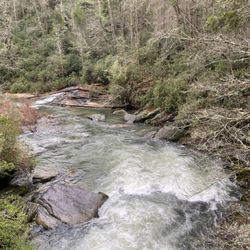
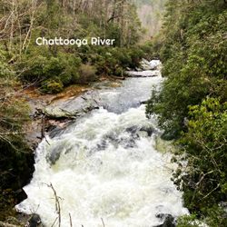
Cobb Bridge sits where Cobb Bridge Road crosses the Chauga River west of Westminster, a quiet corner of Oconee County surrounded by hardwood forest and bordered by the edge of Sumter National Forest. The approach along the narrow pavement reinforces that tucked‑away Upstate feeling, and the posted clearance of 14 feet 7 inches makes it a true two-lane bridge even if it feels tighter than that when you're rolling across. My Sprinter van fit without issue, but I was still glad there was no oncoming traffic on a gray afternoon. The bridge itself is a modern concrete structure rather than a historic iron span, built to replace earlier crossings that once served this rural stretch of the county. Its importance comes less from architectural character and more from function, anchoring one of the most reliable access points to the Chauga River, a waterway known for trout fishing, small rapids, and quiet pools. The river moves over rock shelves just downstream, and even from the deck you can hear the steady rush of water beneath the tree canopy, a sound that defines this part of the Upstate as much as the landscape itself. Because the area remains lightly developed, the bridge works as both a crossing and a gateway to the outdoors. Locals use the pull offs and shoulders to reach the river, and the corridor stays peaceful even on weekends, with only the occasional angler or paddler slipping down to the water. [Review 255 of 2026 - 1392 in South Carolina - 25444 overall] read more


More info about Cobb Iron Bridge


Cobb Iron Bridge - landmarks - Updated July 2026
Best of Westminster
People found Cobb Iron Bridge by searching for…
Places to Take Pictures in Westminster, South Carolina
Photo Spots in Westminster, South Carolina
Historical Sites in Westminster, South Carolina
Scenic Overlook in Westminster, South Carolina
Free Things to Do in Westminster, South Carolina
Public Services & Government in Westminster, South Carolina
View Points in Westminster, South Carolina
Tourist Attractions in Westminster, South Carolina
Bridge in Westminster, South Carolina
Trending Searches in Westminster, SC
Boat Rental near Cobb Iron Bridge
Day Trips near Cobb Iron Bridge
Fireworks near Cobb Iron Bridge
Free Things To Do near Cobb Iron Bridge
Fruit Picking near Cobb Iron Bridge
Jet Ski Rental near Cobb Iron Bridge
Kayak Rental near Cobb Iron Bridge
Landmarks & Historical Buildings near Cobb Iron Bridge
Peach Picking near Cobb Iron Bridge
Picnic Areas near Cobb Iron Bridge
Public Pools near Cobb Iron Bridge
River Swimming near Cobb Iron Bridge
Scenic Drive near Cobb Iron Bridge
Splash Pad near Cobb Iron Bridge
Strawberry Picking near Cobb Iron Bridge
Swimming Holes near Cobb Iron Bridge
Swimming Lakes near Cobb Iron Bridge
U Pick Farms near Cobb Iron Bridge
Browse Articles
Browse Nearby
Browse Brands
Related Searches in Westminster, SC
Best Fishing Locations and Guides in Westminster, South Carolina
Best Waterfalls and Swimming Holes in Westminster, South Carolina
Discover Charming Historic Homes in Westminster, South Carolina
Discover Dog Friendly Trails to Explore in Westminster, South Carolina
Discover Famous Monuments in Westminster, South Carolina
Discover Historic Sites and Places in Westminster, South Carolina
Discover Popular Landmarks in Westminster, South Carolina
Discover Popular Photo Spots in Westminster, South Carolina
Discover the Best Beaches in Westminster, South Carolina
Enjoy Hiking Adventures in Westminster, South Carolina
Enjoy the Best Night View Spots in Westminster, South Carolina
Explore Beautiful Parks and Green Spaces in Westminster, South Carolina
Explore Children's Museums Near Westminster, South Carolina
Explore Family-Friendly Zoos and Wildlife in Westminster, South Carolina
Explore Free Things to Do Around Westminster, South Carolina
Explore Fun Activities to Do in Westminster, South Carolina
Explore Indoor Public Spaces in Westminster, South Carolina
Explore Popular View Points Around Westminster, South Carolina
Explore Scenic Lakes to Visit in Westminster, South Carolina
Explore Top Art Galleries Located in Westminster, South Carolina
Explore Venues & Event Spaces in Westminster, South Carolina
Explore the Scenic River Walk in Westminster, South Carolina
Find Fun Things to Do at Night With Kids in Westminster, South Carolina
Find Top Dog Friendly Parks to Visit in Westminster, South Carolina
Find the Best Bridge Spots in Westminster, South Carolina
Find the Best Playgrounds to Visit in Westminster, South Carolina
Hiking Trails With Waterfalls in Westminster, South Carolina
Perfect Spots to Watch Sunset in Westminster, South Carolina
Popular Kids Activities in Westminster, South Carolina
Popular Places to Take Pictures in Westminster, South Carolina
Popular Things to Do in Westminster, South Carolina
Public Services & Government Offices in Westminster, South Carolina
Relax at Natural Hot Springs Near Westminster, South Carolina
See Top Fireworks Events in Westminster, South Carolina
Top Entertainment Options in Westminster, South Carolina
Top Hiking Trails to Explore in Westminster, South Carolina
Top Things to Do With Kids in Westminster, South Carolina
Tour Famous Lighthouses Located in Westminster, South Carolina
People who viewed Cobb Iron Bridge also viewed
Clarkesville War Memorial
1 review
Seconee Town Historical Marker
1 review
Battle of Narrows Historical Marker
1 review
Summer Home of Joseph Habersham
2 reviews
General John A Wagener Memorial
1 review
Stephens County Historical Courthouse
1 review
Pickens County Courthouse
1 review
Rabun Gap-Nacoochee School Historical Marker
1 review
The Cherokee Path
1 review
City of Toccoa Georgia
1 review