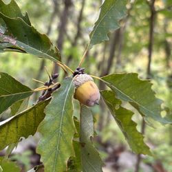
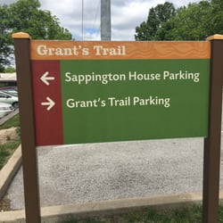
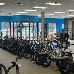
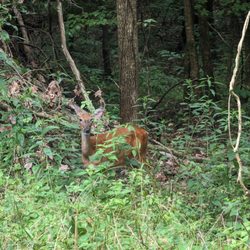
Busch Greenway Photos


You might also consider
More like Busch Greenway
Recommended Reviews - Busch Greenway
Start your review...

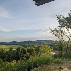
One of the coolest things to do in Weldon Spring is hopping on a bike and exploring the trails that connect you with some of the conservation and park land in the area. This trail threads thru Weldon Spring conservation area, Missouri Research Park and connects you to the Katy Trail. If you don't bike, walk! read more


More info about Busch Greenway
9 Research Park Dr
Weldon Spring Heights, MO 63304
Directions
Hours
Outdoor Amenities


Busch Greenway - mountainbiking - Updated May 2026
Best of Weldon Spring Heights
People found Busch Greenway by searching for…
Parks in Weldon Spring Heights, Missouri
Things to Do in Weldon Spring Heights, Missouri
Walking Trails in Weldon Spring Heights, Missouri
Bikes in Weldon Spring Heights, Missouri
Mountain Bike Trails in Weldon Spring Heights, Missouri
Off Road Trails in Weldon Spring Heights, Missouri
Tourist Attractions in Weldon Spring Heights, Missouri
Bicycles in Weldon Spring Heights, Missouri
Trail in Weldon Spring Heights, Missouri
Electric Bike Shop in Weldon Spring Heights, Missouri
Places to Walk Around in Weldon Spring Heights, Missouri
Nature Reserves in Weldon Spring Heights, Missouri
Trending Searches in Weldon Spring Heights, MO
Browse Articles
Browse Nearby
BEST of Weldon Spring Heights, Missouri Coffee near Busch Greenway
BEST of Weldon Spring Heights, Missouri Restaurants near Busch Greenway
BEST of Weldon Spring Heights, Missouri Things to Do near Busch Greenway
BEST of Weldon Spring Heights, Missouri Parks near Busch Greenway
BEST of Weldon Spring Heights, Missouri Shopping near Busch Greenway
BEST of Weldon Spring Heights, Missouri Hotels near Busch Greenway
BEST of Weldon Spring Heights, Missouri Breakfast near Busch Greenway
Browse Brands
Related Searches in Weldon Spring Heights, MO
Affordable Bike Repair Services in Weldon Spring Heights, Missouri
Affordable Bike Tune Up Services in Weldon Spring Heights, Missouri
Best Dog Hiking Trails Around Weldon Spring Heights, Missouri
Best Fishing Locations and Guides in Weldon Spring Heights, Missouri
Best Lookout Points to Visit in Weldon Spring Heights, Missouri
Best Nature Trails for Hiking in Weldon Spring Heights, Missouri
Best Places for Horseback Riding in Weldon Spring Heights, Missouri
Best Spots for Star Gazing in Weldon Spring Heights, Missouri
Best Used Bikes for Sale Near Weldon Spring Heights, Missouri
Check Out Off Road Trails in Weldon Spring Heights, Missouri
Discover Dog Friendly Trails to Explore in Weldon Spring Heights, Missouri
Discover Popular Bike Trails in Weldon Spring Heights, Missouri
Discover Scenic Mountain Bike Trails Near Weldon Spring Heights, Missouri
Discover Top Nature Parks to Visit in Weldon Spring Heights, Missouri
Discover the Best Night Hike Trails in Weldon Spring Heights, Missouri
Dog-Friendly Hikes With Dogs in Weldon Spring Heights, Missouri
Effective Stairs Workout Spots in Weldon Spring Heights, Missouri
Enjoy Hiking Adventures in Weldon Spring Heights, Missouri
Enjoy Rope Swing Adventures in Weldon Spring Heights, Missouri
Enjoy the Best Walking Trails in Weldon Spring Heights, Missouri
Explore BMX Bike Shops Near Weldon Spring Heights, Missouri
Explore Beautiful Parks and Green Spaces in Weldon Spring Heights, Missouri
Explore Easy Hikes Perfect for All in Weldon Spring Heights, Missouri
Explore Popular Scenic Overlook Points in Weldon Spring Heights, Missouri
Explore Popular View Points Around Weldon Spring Heights, Missouri
Explore Scenic Lakes to Visit in Weldon Spring Heights, Missouri
Explore Secret Spots Worth Visiting in Weldon Spring Heights, Missouri
Explore the Best Swimming Holes Around Weldon Spring Heights, Missouri
Explore the Best Trail Options in Weldon Spring Heights, Missouri
Family Friendly Hiking With Kids in Weldon Spring Heights, Missouri
Find Beautiful Views in Weldon Spring Heights, Missouri
Find Cheap Bike Rentals Around Weldon Spring Heights, Missouri
Find Top-Rated Waterfalls in Weldon Spring Heights, Missouri Now
Find a Fixed Gear Bike Shop in Weldon Spring Heights, Missouri
Find the Best Bikes Available in Weldon Spring Heights, Missouri
Find the Best Scenic View Locations in Weldon Spring Heights, Missouri
Off Leash Dog Hiking Trails in Weldon Spring Heights, Missouri
Perfect Spots to Watch Sunset in Weldon Spring Heights, Missouri
Plan a Scenic Drive Route Near Weldon Spring Heights, Missouri
Popular Picnic Spots to Visit in Weldon Spring Heights, Missouri
Safe River Swimming Areas in Weldon Spring Heights, Missouri
Shop for Mountain Bikes at Local Stores in Weldon Spring Heights, Missouri
Stair Climbing Activities and Gyms in Weldon Spring Heights, Missouri
Top Hiking Trails to Explore in Weldon Spring Heights, Missouri
Top Running Trails to Explore in Weldon Spring Heights, Missouri
Top-Rated Camping Sites in Weldon Spring Heights, Missouri
Trusted Electric Bike Repair in Weldon Spring Heights, Missouri
Trusted Kids Bike Shop Locations in Weldon Spring Heights, Missouri
Trusted Used Bike Shop Services in Weldon Spring Heights, Missouri
Uncover the Best Secluded Spots Around Weldon Spring Heights, Missouri