Burro Schmidt Tunnel Photos


You might also consider
More like Burro Schmidt Tunnel
Recommended Reviews - Burro Schmidt Tunnel
Start your review...

Reviews With Photos

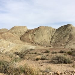
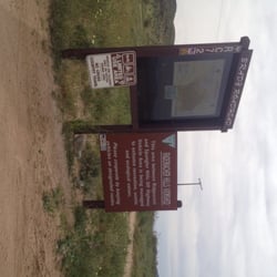
Want to bust a mission? Drive over sand, rocks, puddles and think you're going nowhere, then this is a must do! Although, everyone says you need/should take a 4x4, we went in a regular car and made it. Tread lightly and you'll be fine. The easiest route is off the 14 north. The 14 north has a worn out wooden sign on the righthandside that directs to a small open entrance. From the 14 south, look out for 3 big billboards (one that says 21 miles to shell gas station) - the entrance will be right after the billboards on the left. The entrance will look like it's gated off, but trust me there is a small opening. It's about 8-9 miles in, took us about 30-40 mins. to get to the tunnel but we were going extremely slow, with a 4x4, you'll prob get there faster. Follow the road and you'll see signs that tell you "schmidts tunnel this way". We thought we were going the wrong way, the signs are sporadic, so pay attention. Once you see Scmidts abandoned house, pass it and the tunnel will be at the end of the road. The tunnel is about a 1/2 mile, you can either go left or right at the end, we went right and got blessed with the most beautiful view. Bring a flashlight it's super dark, and pay attention, cuz at some parts the cave is low. I'm short and still banged my head. Such an amazing experience, to think that one man spent 30 years of his life carving this tunnel!

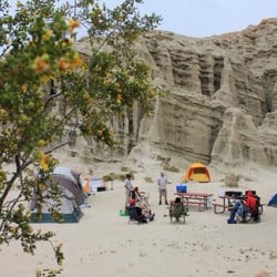
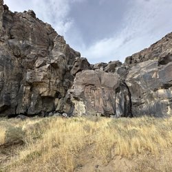
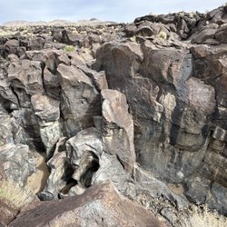
So this guy spent over 30 years hand-digging this mile-long tunnel in the middle of nowhere. Brandon D. and I, while on a trip to visit his family in Ridgecrest, read up on William "Burro" Schmidt and got a bit curious about that tunnel of his. We all piled into Mr. D's truck and headed on down the 14, and found the wooden sign (which is only found on the northbound side - http://www.yelp.com/biz_photos/burro-schmidts-tunnel-inyokern#WNeeMag3NJb0CAARbWJa4A), that is the sole directional indicator of where the tunnel is along the road. The sign reads 8 miles, but it's really closer to 10. You turn onto EP 15 (listed as Last Chance Canyon Rd on Google), a rocky pathway toward the tunnel that I HIGHLY recommend having 4-wheel drive to navigate. All along the way we were passing dirtbikers and people in other off-roading vehicles. The signage along the way consisted mostly of "TUNNEL" with an arrow being spray-painted on various objects like rusted over barrels and detached car doors and even a large pipe (http://www.yelp.com/biz_photos/burro-schmidts-tunnel-inyokern#5nMUqmyv609yNrdWIXNQxA). The traditional signs have been weathered down and are often too small to see (http://www.yelp.com/biz_photos/burro-schmidts-tunnel-inyokern#xeoZh-T9wGUNAZfpJ6Z-mw). After passing Schmidt's abandoned cabin (http://www.yelp.com/biz_photos/burro-schmidts-tunnel-inyokern#2WSSZ0x8WZkrSARYg10_5g), we arrived at the tunnel to find loads of people parked outside (http://www.yelp.com/biz_photos/burro-schmidts-tunnel-inyokern#mqdYGo8yXdB4aSaWJsv8dw). At first I was a bit bummed, hoping to not have to deal with a crowd, but actually only so many people were going into the tunnel at a time and, really, it was comforting having that many people nearby in case there was trouble. There was no caretaker that we saw the entire time we were there. The tunnel itself (http://www.yelp.com/biz_photos/burro-schmidts-tunnel-inyokern#Pdv2rDB5ShFtpRthdrJ5Og) has a few low ceilings and you have to stoop a bit while going through or else this can happen (http://www.yelp.com/biz_photos/burro-schmidts-tunnel-inyokern#jGCds8lAp2zIpwNOOkS_Iw). From time to time we were finding bloody handprints on the walls (http://www.yelp.com/biz_photos/burro-schmidts-tunnel-inyokern#rS6Ptco9KutSAkh2XD5rEg). It gets pretty eerie in there. If you intend to explore the tunnel, BRING A FLASHLIGHT. It's pitch black in there, and after a few yards you stop seeing daylight. Here's a shot taken of our flashlight's shutter made smaller so the light is narrower, but goes further into the tunnel (http://www.yelp.com/biz_photos/burro-schmidts-tunnel-inyokern#uch7TuH5TLwIlj-H6LwK6Q). I'm not kidding. It's DARK. About a quarter of the way through the tunnel, on the left, there's a split with mining cart rails and a metal door (http://www.yelp.com/biz_photos/burro-schmidts-tunnel-inyokern#JJUP7FHymryEmFu67o4K9w). There's nothing really in there more than other people's litter. Near the end of the tunnel, it forks. To the right is an exit that opens to a pretty nice view from the summit (http://www.yelp.com/biz_photos/burro-schmidts-tunnel-inyokern#_3_YQZ2SFfUhsWqKacx9rA). The left fork leads to an ever curving and narrowing tunnel that gave us a rather spooky feeling. We turned back when Brandon's dad told us the wall near the fork was marked "STAY OUT." I am 5'6" and I was able to stand upright most of the time while going through the tunnel (http://www.yelp.com/biz_photos/burro-schmidts-tunnel-inyokern#hKAZIOJbbhLlMIJ1i5QCHQ), but I did have to bend down a few times while walking through. Truly, Burro Schmidt's is another case of roadside gold, if you're willing to make the trek.

It's hard to believe that people accessed places like this over 100 years ago BEFORE roads and cars, when getting to them now in the comfort of a 4wd truck with good suspension is an adventure. To get to the tunnel and the house he lived in for years, you travel about 10 miles on a all dirt, somewhat rocky path, passing the occasional off the grid-er, all the while wondering when the hills have eyes people are going to come hunt you down. We saw no signage until way more than half way in. "TUNNEL" with an arrow on a oil can reminded us why we were taking this journey and gave us time to really admire the determination of this Schmidt guy that spent 35+ years living and building a tunnel in this terrain without automated machinery. To be perfectly honest...half admire, half think he was down right nuts. But I suppose the lure of gold will do that to some people. You arrive to the remnants of his house that are fenced off. It's perched on a hill with a damn good view, overlooking the area we traveled to get there. It does have a fence around it, but easily accessible. It's wall papered with old boxes and newspapers from decades ago. There are even some artifacts laying on a table that I'm shocked no one has stolen. Up above from the house it the famous tunnel, basically a hole in the side of the mountain. Digging it all of the dirt and rocks would not be how I would want to spend my life, but job well done Mr. Schmidt. :)

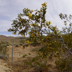
Out in the middle of the Mojave desert William Henry Schmidt spent 38 years hand digging this tunnel through a mountain. Everyone likes the tunnel, I was fascinated by his house and the work shed or garage. Inside the building there are tons of old labels from food wrappers, tabacco and old magazines dated back to the 30s. They have fenced off the house because morons were damaging it. Let's not trash this place, the weather out here does enough damage.

My wife and I really enjoyed our visit here and our walk through the tunnel. The drive in from Highway 14 is tough if you have a standard, low, 2wheel drive car. I don't recommend it. I drive a 2 wheel drive Explorer that is a little higher and wider tires. It took 50 minutes of careful driving to get to the tunnel. No huge rocks or washouts but a lot of loose deep sand that requires your attention. Be prepared, drive the right car and don't let the drive in stop you from visiting. There are enough signs along the way, better to call the trail markers, so you won't get lost. I used Waze and it took out any guess work. Once at the tunnel the opening looks very small and many people think that it means you need to crawl through and won't go. But just go in 15 feet or so and you can stand up all the way and it is good. My wife was very concerned and didn't want to go in until she could see me standing fully upright once I got all the way inside. My wife carried a lantern with 360 light and I had a flashlight with a thinner beam for more distance. It was a perfect combination. When you are inside you can look back and see the light at entrance getting smaller but cannot see light at the far end. Don't worry, there is a 90 degree tun near the end that blocks your view of the exit but it is there. Deep inside it really does feel like an adventure. It's just spooky enough to make you feel like you accomplished something by getting all the way through. My wife was flat out scared but was determined and did it. There is a great view spot at the far end. We walked off to both sides of opening and loved the views. There was a couple coming the other way on our way through and it was kind of fun meeting nice people in such an otherworldly place. Inside the tunnel it does not smell, there was only the tiny amount of dust we kicked up with our feet and no wind. Eerily quiet. You can still see the ore cart tracks in a couple places and it really brings to mind the immense amount or labor and dedication, or possibly obsession, this man had to finish it. It's stunning to contemplate. Go and walk it but don't just walk it, take the time to appreciate this one man, hand dug, 38 year creation. read more

3 years ago
6 years ago
Very nice off road experience !! Great views! U should have a vehicle like and suv or truck Some areas required clearance read more


8 years ago
Want to bust a mission? Drive over sand, rocks, puddles and think you're going nowhere, then this is a must do! Although, everyone says you need/should take a 4x4, we went in a regular car and made it. Tread lightly and you'll be fine. The easiest route is off the 14 north. The 14 north has a worn out wooden sign on the righthandside that directs to a small open entrance. From the 14 south, look out for 3 big billboards (one that says 21 miles to shell gas station) - the entrance will be right after the billboards on the left. The entrance will look like it's gated off, but trust me there is a small opening. It's about 8-9 miles in, took us about 30-40 mins. to get to the tunnel but we were going extremely slow, with a 4x4, you'll prob get there faster. Follow the road and you'll see signs that tell you "schmidts tunnel this way". We thought we were going the wrong way, the signs are sporadic, so pay attention. Once you see Scmidts abandoned house, pass it and the tunnel will be at the end of the road. The tunnel is about a 1/2 mile, you can either go left or right at the end, we went right and got blessed with the most beautiful view. Bring a flashlight it's super dark, and pay attention, cuz at some parts the cave is low. I'm short and still banged my head. Such an amazing experience, to think that one man spent 30 years of his life carving this tunnel! read more


14 years ago
So this guy spent over 30 years hand-digging this mile-long tunnel in the middle of nowhere. Brandon D. and I, while on a trip to visit his family in Ridgecrest, read up on William "Burro" Schmidt and got a bit curious about that tunnel of his. We all piled into Mr. D's truck and headed on down the 14, and found the wooden sign (which is only found on the northbound side - http://www.yelp.com/biz_photos/burro-schmidts-tunnel-inyokern#WNeeMag3NJb0CAARbWJa4A), that is the sole directional indicator of where the tunnel is along the road. The sign reads 8 miles, but it's really closer to 10. You turn onto EP 15 (listed as Last Chance Canyon Rd on Google), a rocky pathway toward the tunnel that I HIGHLY recommend having 4-wheel drive to navigate. All along the way we were passing dirtbikers and people in other off-roading vehicles. The signage along the way consisted mostly of "TUNNEL" with an arrow being spray-painted on various objects like rusted over barrels and detached car doors and even a large pipe (http://www.yelp.com/biz_photos/burro-schmidts-tunnel-inyokern#5nMUqmyv609yNrdWIXNQxA). The traditional signs have been weathered down and are often too small to see (http://www.yelp.com/biz_photos/burro-schmidts-tunnel-inyokern#xeoZh-T9wGUNAZfpJ6Z-mw). After passing Schmidt's abandoned cabin (http://www.yelp.com/biz_photos/burro-schmidts-tunnel-inyokern#2WSSZ0x8WZkrSARYg10_5g), we arrived at the tunnel to find loads of people parked outside (http://www.yelp.com/biz_photos/burro-schmidts-tunnel-inyokern#mqdYGo8yXdB4aSaWJsv8dw). At first I was a bit bummed, hoping to not have to deal with a crowd, but actually only so many people were going into the tunnel at a time and, really, it was comforting having that many people nearby in case there was trouble. There was no caretaker that we saw the entire time we were there. The tunnel itself (http://www.yelp.com/biz_photos/burro-schmidts-tunnel-inyokern#Pdv2rDB5ShFtpRthdrJ5Og) has a few low ceilings and you have to stoop a bit while going through or else this can happen (http://www.yelp.com/biz_photos/burro-schmidts-tunnel-inyokern#jGCds8lAp2zIpwNOOkS_Iw). From time to time we were finding bloody handprints on the walls (http://www.yelp.com/biz_photos/burro-schmidts-tunnel-inyokern#rS6Ptco9KutSAkh2XD5rEg). It gets pretty eerie in there. If you intend to explore the tunnel, BRING A FLASHLIGHT. It's pitch black in there, and after a few yards you stop seeing daylight. Here's a shot taken of our flashlight's shutter made smaller so the light is narrower, but goes further into the tunnel (http://www.yelp.com/biz_photos/burro-schmidts-tunnel-inyokern#uch7TuH5TLwIlj-H6LwK6Q). I'm not kidding. It's DARK. About a quarter of the way through the tunnel, on the left, there's a split with mining cart rails and a metal door (http://www.yelp.com/biz_photos/burro-schmidts-tunnel-inyokern#JJUP7FHymryEmFu67o4K9w). There's nothing really in there more than other people's litter. Near the end of the tunnel, it forks. To the right is an exit that opens to a pretty nice view from the summit (http://www.yelp.com/biz_photos/burro-schmidts-tunnel-inyokern#_3_YQZ2SFfUhsWqKacx9rA). The left fork leads to an ever curving and narrowing tunnel that gave us a rather spooky feeling. We turned back when Brandon's dad told us the wall near the fork was marked "STAY OUT." I am 5'6" and I was able to stand upright most of the time while going through the tunnel (http://www.yelp.com/biz_photos/burro-schmidts-tunnel-inyokern#hKAZIOJbbhLlMIJ1i5QCHQ), but I did have to bend down a few times while walking through. Truly, Burro Schmidt's is another case of roadside gold, if you're willing to make the trek. read more


11 years ago
It's hard to believe that people accessed places like this over 100 years ago BEFORE roads and cars, when getting to them now in the comfort of a 4wd truck with good suspension is an adventure. To get to the tunnel and the house he lived in for years, you travel about 10 miles on a all dirt, somewhat rocky path, passing the occasional off the grid-er, all the while wondering when the hills have eyes people are going to come hunt you down. We saw no signage until way more than half way in. "TUNNEL" with an arrow on a oil can reminded us why we were taking this journey and gave us time to really admire the determination of this Schmidt guy that spent 35+ years living and building a tunnel in this terrain without automated machinery. To be perfectly honest...half admire, half think he was down right nuts. But I suppose the lure of gold will do that to some people. You arrive to the remnants of his house that are fenced off. It's perched on a hill with a damn good view, overlooking the area we traveled to get there. It does have a fence around it, but easily accessible. It's wall papered with old boxes and newspapers from decades ago. There are even some artifacts laying on a table that I'm shocked no one has stolen. Up above from the house it the famous tunnel, basically a hole in the side of the mountain. Digging it all of the dirt and rocks would not be how I would want to spend my life, but job well done Mr. Schmidt. :) read more


11 years ago
Out in the middle of the Mojave desert William Henry Schmidt spent 38 years hand digging this tunnel through a mountain. Everyone likes the tunnel, I was fascinated by his house and the work shed or garage. Inside the building there are tons of old labels from food wrappers, tabacco and old magazines dated back to the 30s. They have fenced off the house because morons were damaging it. Let's not trash this place, the weather out here does enough damage. read more


9 years ago


More info about Burro Schmidt Tunnel
Burro Schmidt Tunnel Rd
Inyokern, CA 93527
Directions
Hours
Outdoor Amenities
Ask the Community - Burro Schmidt Tunnel


Why does Yelp recommend reviews?
1 review that is not currently recommended
The reviews below are not factored into the business's overall star rating.
2 years ago
Burro Schmidt Tunnel - hiking - Updated August 2026
Best of Inyokern
People found Burro Schmidt Tunnel by searching for…
Off Road Trails in Inyokern, CA
Abandoned Buildings in Inyokern, CA
Beautiful Views in Inyokern, CA
Parks for Kids in Inyokern, CA
Hiking With Kids in Inyokern, CA
Scenic Overlook in Inyokern, CA
Running Trails in Inyokern, CA
Places to Take Pictures in Inyokern, CA
Secluded Spots in Inyokern, CA
Trending Searches in Inyokern, CA
Browse Articles
Browse Brands
Related Searches in Inyokern, CA
Best Fishing Locations and Guides in Inyokern, California
Best Places for Horseback Riding in Inyokern, California
Best Spots for Star Gazing in Inyokern, California
Check Out Off Road Trails in Inyokern, California
Discover Dog Friendly Beaches Near Inyokern, California
Discover the Best Night Hike Trails in Inyokern, California
Dog-Friendly Hikes With Dogs in Inyokern, California
Enjoy Camping Adventures Around Inyokern, California
Enjoy Exciting Mountain Biking Adventures in Inyokern, California
Enjoy Tent Camping Spots Around Inyokern, California
Enjoy the Best Walking Trails in Inyokern, California
Experience Stunning Sunset Views in Inyokern, California
Explore Beautiful Parks and Green Spaces in Inyokern, California
Explore Easy Hikes Perfect for All in Inyokern, California
Explore Free Things to Do Around Inyokern, California
Explore Fun Activities to Do in Inyokern, California
Explore Popular Boat Charters Near Inyokern, California
Explore Popular Campgrounds Near Inyokern, California
Explore Popular RV Parks Around Inyokern, California
Explore Popular Scenic Views Near Inyokern, California
Explore Scenic Lakes to Visit in Inyokern, California
Explore Top Dog Parks in Inyokern, California Near You
Explore the Best Swimming Holes Around Inyokern, California
Family Friendly Hiking With Kids in Inyokern, California
Find Fun Things to Do With Kids in Inyokern, California
Find Parks and Recreation Activities in Inyokern, California
Find Top-Rated Waterfalls in Inyokern, California Now
Find the Best Playgrounds to Visit in Inyokern, California
Find the Best Scenic View Locations in Inyokern, California
Fun Things for Kids in Inyokern, California
Hiking Trails With Waterfalls in Inyokern, California
Perfect Spots to Watch Sunset in Inyokern, California
Popular Fishing Spots to Explore in Inyokern, California
Popular Kids Activities in Inyokern, California
Popular Places to Take Pictures in Inyokern, California
Popular Things to Do in Inyokern, California
Safe River Swimming Areas in Inyokern, California
Safe and Fun Parks for Kids in Inyokern, California
Top Hiking Trails to Explore in Inyokern, California
Top Paddleboarding Activities in Inyokern, California
Top Playgrounds for Kids to Enjoy in Inyokern, California
Top RV Campgrounds to Visit in Inyokern, California
Top Running Trails to Explore in Inyokern, California
Top Swimming Lakes to Enjoy in Inyokern, California


