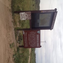
Short Canyon Photos


You might also consider
More like Short Canyon
Recommended Reviews - Short Canyon
Start your review...

5 years ago
The best spot to relax in to watch the snow packed peaks in winter or Super Bloom near April. It's only a 10-15 min drive from the main road, just east of Highway 395 for access road next to Brady's Market aka Mobil Gas Station. Right turn off 395 South, left over divided Highway from 395 North...look for the giant billboard. Accessible in my common Nissan Rogue and PT Cruiser during light rain, but I parked at pipeline crossroads due to softer sand on the dirt path to the peaks. Amazing View with some R&R time. read more


4 years ago
13 years ago
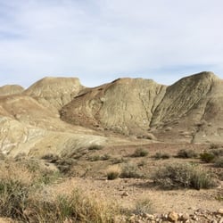
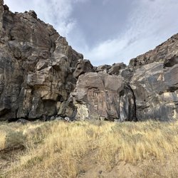
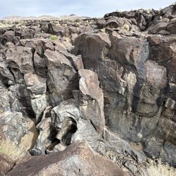
A relatively easy hike for the area with great views. Apparently during certain times of the year, there's a waterfall, which the trail is supposed to lead you to. Even after some recent rains and walking the entire length of the creek, there wasn't a waterfall that we could find today. Still, it made for a nice, moderate walk with some boulder-hopping as the trail becomes minimally maintained after approaching the creek. With so much grass hanging over what becomes more of a deer path, watch out for ticks if you go during the hotter months. To get to Short Canyon, you take a dirt road that starts near the Brady's Mini Mart and Mobil Station off the 395 (just north of where the 14 merges into it). Take Short Canyon Rd 'til it ends in an unpaved parking lot and just walk up the trail that starts there. Once you get over the ridge, you get gorgeous views of mountains to the west and the valley below to the east. It's 360 degrees of majesty. All over the place there were shot gun shells, bullet casings (mostly for larger rifles), and broken clay pigeons. You'll be driving along on the dirt road and suddenly there's hundreds of the things just laying about. read more


9 years ago
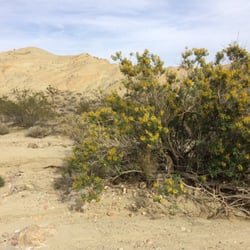
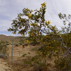
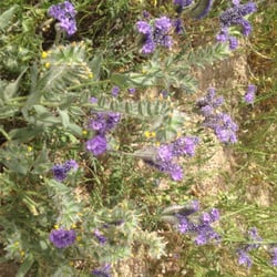
One of the best times of the year to visit Short Canyon is in late March and early April. So many wildflowers are in bloom around this time, including the California poppy, Indian paint brush, and Grape soda lupine. Oh, and the view of Owens Peak and Five fingers is pretty good also. read more


More info about Short Canyon
Short Canyon Rd
Inyokern, CA 93527
Directions
(760) 384-5400
Call Now
Hours
Outdoor Amenities


Short Canyon - hiking - Updated August 2026
Best of Inyokern
People found Short Canyon by searching for…
Hiking Trails With Waterfalls in Inyokern, CA
Dirt Bike Riding in Inyokern, CA
Parks for Kids in Inyokern, CA
Off Road Trails in Inyokern, CA
Hiking With Kids in Inyokern, CA
Easy Hiking Trails in Inyokern, CA
Waterfalls and Swimming Holes in Inyokern, CA
Places to Visit in Inyokern, CA
Running Trails in Inyokern, CA
Places to Take Pictures in Inyokern, CA
Beautiful Views in Inyokern, CA
Trending Searches in Inyokern, CA
Browse Articles
Browse Brands
Related Searches in Inyokern, CA
Best Fishing Locations and Guides in Inyokern, California
Best Places for Horseback Riding in Inyokern, California
Best Spots for Star Gazing in Inyokern, California
Check Out Off Road Trails in Inyokern, California
Discover Dog Friendly Beaches Near Inyokern, California
Discover the Best Night Hike Trails in Inyokern, California
Dog-Friendly Hikes With Dogs in Inyokern, California
Enjoy Camping Adventures Around Inyokern, California
Enjoy Exciting Mountain Biking Adventures in Inyokern, California
Enjoy Tent Camping Spots Around Inyokern, California
Enjoy the Best Walking Trails in Inyokern, California
Experience Stunning Sunset Views in Inyokern, California
Explore Beautiful Parks and Green Spaces in Inyokern, California
Explore Easy Hikes Perfect for All in Inyokern, California
Explore Free Things to Do Around Inyokern, California
Explore Fun Activities to Do in Inyokern, California
Explore Popular Boat Charters Near Inyokern, California
Explore Popular Campgrounds Near Inyokern, California
Explore Popular RV Parks Around Inyokern, California
Explore Popular Scenic Views Near Inyokern, California
Explore Scenic Lakes to Visit in Inyokern, California
Explore Top Dog Parks in Inyokern, California Near You
Explore the Best Swimming Holes Around Inyokern, California
Family Friendly Hiking With Kids in Inyokern, California
Find Fun Things to Do With Kids in Inyokern, California
Find Parks and Recreation Activities in Inyokern, California
Find Top-Rated Waterfalls in Inyokern, California Now
Find the Best Playgrounds to Visit in Inyokern, California
Find the Best Scenic View Locations in Inyokern, California
Fun Things for Kids in Inyokern, California
Hiking Trails With Waterfalls in Inyokern, California
Perfect Spots to Watch Sunset in Inyokern, California
Popular Fishing Spots to Explore in Inyokern, California
Popular Kids Activities in Inyokern, California
Popular Places to Take Pictures in Inyokern, California
Popular Things to Do in Inyokern, California
Safe River Swimming Areas in Inyokern, California
Safe and Fun Parks for Kids in Inyokern, California
Top Hiking Trails to Explore in Inyokern, California
Top Paddleboarding Activities in Inyokern, California
Top Playgrounds for Kids to Enjoy in Inyokern, California
Top RV Campgrounds to Visit in Inyokern, California
Top Running Trails to Explore in Inyokern, California
Top Swimming Lakes to Enjoy in Inyokern, California