Rademacher Hills Trail Photos


You might also consider
More like Rademacher Hills Trail
Recommended Reviews - Rademacher Hills Trail
Start your review...

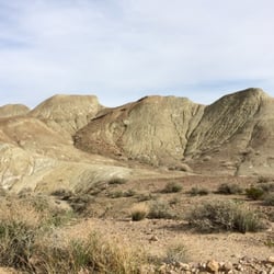
It was sunset on the trail... I had never been to Ridgecrest before. An important little place in the middle of a desert. As for this trail hike, we took a moderate one up the mountain to the peak to sit and take in the views on all sides. It really depends who you go with. The desert can be a lonely place. Especially as the day comes to a close, it is so quiet here, it could be just you and your thoughts. Sobering. We saw some rabbits and lizards. Be on the watch for coyotes and rattlesnakes. The steep trek down I thought, was harder than going up. Make sure you have really good hiking shoes. If you come here on a whim let's say, sandals or flip flops are not going to cut it. Bring plenty of water, very hot in summer and keep in mind that there are no bathrooms here. Please pick up all your trash. This was a beautiful, clean place. The parking area felt safe and fortunately for us, there were not a lot of people there on this given Sunday. I would go back in a heartbeat. The summit views were spectacular and I always welcome the exercise and time to reflect. It can also feel very romantic. I love the desert. read more


9 years ago
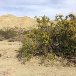
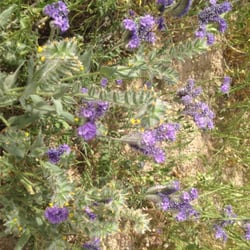
I just arrived in town and this was suggested to me at the Maturango Museum, as a quick place to go to become acquainted with some of the local plants. There were a couple of trail heads, the one behind the college having a parking lot close to the road. I walked a bit to see what was there and took some photos. I'm sure it would be more interesting the further out a person could go. It reminded me of bike rides in a state forest in Florida and I'm sure a quicker view would be more interesting but less productive for photography. read more


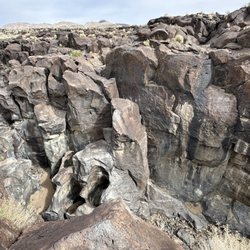
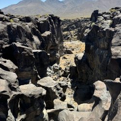
When I first found this hiking spot, gotta be honest, I wasn't too excited because of the lack of greenery, trees, trash cans, etc. but once my hubs started walking through the pathways, I was excited to come back. The few times I've come, I brought our pup and have left him off the leash when were far away enough from the parking lot. This place is pet friendly but it doesn't seem like a lot of pet owners clean up after their pups. And that may be because there aren't any trash cans in sight. We've dumped our pups poop behind the CCC's children center or a trash can on campus. Even though this hiking spot lacks trash cans, it does have a ton of trails to take that starts behind CCC and goes out towards the mountains. We haven't ventured out too far just yet, but I can't wait to see how many other trails we find. Also, another huge plus is there are markers you can follow...not to mention, it's hard to not be able to find your way back. Honestly, there are some many trails you're not likely to run into anyone else. I have seen quite a bit of bikers and people on dirt bikes/dune buggies, but it can be a bit hard to see through the desert plants. There's a few signs before entering the hiking trails that gives info about desert turtles, but we haven't seen any yet. The only critters I've seen are lizards and ants. One thing to be careful of is the broken glass all throughout the desert. It can be pretty, but sharp! read more


14 years ago
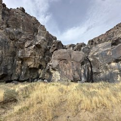
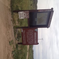
While at the Maturango Museum, my boyfriend's dad picked up a photocopied handout on the Rademacher trails, got nostalgic of his times wandering around there with his friends, meeting old prospectors who still came through the area, and decided to pile us all in the truck and head on over there. After driving south down College Heights Blvd, we turned left onto a dirt road (Belle Vista - which was mostly flat, through a bit of a washboard), crossed a trail used by kids on off-roading vehicles, and parked in the little lot in front of the Sunland Trailhead. Here's a map, which I hope will prove useful should you decide to embark on a hike in that area: http://www.blm.gov/pgdata/etc/medialib/blm/ca/pdf/pdfs/ridgecrest_pdfs.Par.25038.File.dat/Rademacher_5.pdf A sign at the start of the trail, which presents you with a map and information on the local flora and fauna also has a sign asking that you not shoot anything out of respect for people's property. And of course there are bullet holes through the sign and the other displays and placards at the trailhead. Anyway, we did the Sunland hike. It took less than an hour. Most would probably do it faster, but we stopped to check out this abandoned mine on the way up the switchback (mostly because we needed a breather). Even if there weren't barbed wire around the entrance, it wouldn't exactly be easy to get into it since it's a straight drop for several yards and you can't see very far down. Pretty interesting. We watched the sun set, standing near the Ron Henry Interpretive Site. It's the peak of the trail, though sort of a valley between Sky Point and Andrew Peak. From there we could see houses on the other side of the hills, which the boyfriend's dad was amazed to see, swearing they weren't there when he used to hike in those hills. Occasionally you can hear people talking in their yards when the wind blows in our direction. The trails are pretty well maintained, one of those where they put a log every few feet of the switchback as a step. The Sunland Trail is covered with loose gravel, though, so it can be a bit treacherous as you walk down the hill and the rocks start to slide out from under you. That trail also connects with several of the other trails that appear on the map linked above. read more


More info about Rademacher Hills Trail
Belle Vista Rd
Ridgecrest, CA 93555
Directions
Hours
Outdoor Amenities
You might also consider


Rademacher Hills Trail - hiking - Updated May 2026
Best of Ridgecrest
People found Rademacher Hills Trail by searching for…
Things to Do in Ridgecrest, CA
Hiking Trails in Ridgecrest, CA
Off Road Trails in Ridgecrest, CA
Running Trails in Ridgecrest, CA
Natural Hot Springs in Ridgecrest, CA
Hikes With Dogs in Ridgecrest, CA
Tourist Attractions in Ridgecrest, CA
Dirt Bike Riding in Ridgecrest, CA
Watch Sunset in Ridgecrest, CA
Walking Trails in Ridgecrest, CA
Parks for Kids in Ridgecrest, CA
Playgrounds for Kids in Ridgecrest, CA
Scenic Overlook in Ridgecrest, CA
Scenic Views in Ridgecrest, CA
Hiking With Kids in Ridgecrest, CA
Trending Searches in Ridgecrest, CA
Bounce House Rentals near Rademacher Hills Trail
Campgrounds near Rademacher Hills Trail
Flower Shop near Rademacher Hills Trail
Garage Sales near Rademacher Hills Trail
Hair near Rademacher Hills Trail
Nurseries & Gardening near Rademacher Hills Trail
Party Equipment Rentals near Rademacher Hills Trail
Pedicure near Rademacher Hills Trail
Pick Your Own Farms near Rademacher Hills Trail
Picnic Areas near Rademacher Hills Trail
Places To Take Pictures near Rademacher Hills Trail
Pool Supplies near Rademacher Hills Trail
Running Trails near Rademacher Hills Trail
Rv Rental near Rademacher Hills Trail
Browse Articles
Browse Nearby
Browse Brands
Related Searches in Ridgecrest, CA
Best Fishing Locations and Guides in Ridgecrest, California
Best Fun Things to Do in Ridgecrest, California
Best Places for Horseback Riding in Ridgecrest, California
Best Spots for Star Gazing in Ridgecrest, California
Best Water Parks for Kids in Ridgecrest, California
Discover Dog Friendly Trails to Explore in Ridgecrest, California
Discover Popular Bike Trails in Ridgecrest, California
Discover Popular Photo Spots in Ridgecrest, California
Discover a Hiking Trail in Ridgecrest, California
Discover the Best Night Hike Trails in Ridgecrest, California
Dog-Friendly Hikes With Dogs in Ridgecrest, California
Enjoy Exciting Mountain Biking Adventures in Ridgecrest, California
Enjoy Tent Camping Spots Around Ridgecrest, California
Enjoy the Best Walking Trails in Ridgecrest, California
Exciting Cliff Jumping Spots in Ridgecrest, California
Experience Stunning Sunset Views in Ridgecrest, California
Explore Beautiful Parks and Green Spaces in Ridgecrest, California
Explore Easy Hikes Perfect for All in Ridgecrest, California
Explore Family-Friendly Zoos and Wildlife in Ridgecrest, California
Explore Free Things to Do Around Ridgecrest, California
Explore Fun Activities to Do in Ridgecrest, California
Explore Popular Campgrounds Near Ridgecrest, California
Explore Popular RV Parks Around Ridgecrest, California
Explore Scenic Lakes to Visit in Ridgecrest, California
Explore Top Dog Parks in Ridgecrest, California Near You
Explore Top Water Parks in Ridgecrest, California Today
Explore the Best Swimming Holes Around Ridgecrest, California
Explore the Best Trail Options in Ridgecrest, California
Find Fun Things to Do With Kids in Ridgecrest, California
Find the Best Playgrounds to Visit in Ridgecrest, California
Find the Best Scenic View Locations in Ridgecrest, California
Find the Best Swimming Pools in Ridgecrest, California Today
Fun Toddler Activities to Try in Ridgecrest, California
Must-See Tourist Attractions Around Ridgecrest, California
Off Leash Dog Hiking Trails in Ridgecrest, California
Plan a Scenic Drive Route Near Ridgecrest, California
Popular Fishing Spots to Explore in Ridgecrest, California
Popular Kids Activities in Ridgecrest, California
Popular Picnic Spots to Visit in Ridgecrest, California
Popular Places to Take Pictures in Ridgecrest, California
Popular Things to Do in Ridgecrest, California
Relax at Natural Hot Springs Near Ridgecrest, California
Safe River Swimming Areas in Ridgecrest, California
Safe and Fun Parks for Kids in Ridgecrest, California
Top Places to Visit in Ridgecrest, California for Sightseeing
Top Playgrounds for Kids to Enjoy in Ridgecrest, California
Top Running Trails to Explore in Ridgecrest, California
Top Swimming Lakes to Enjoy in Ridgecrest, California
Top Things to Do With Kids in Ridgecrest, California
Top-Rated Basketball Courts to Play at in Ridgecrest, California
People who viewed Rademacher Hills Trail also viewed
Red Rock Canyon State Park
119 reviews
Rademacher Hills Viewshed
1 review
Short Canyon
4 reviews
Burro Schmidt Tunnel
9 reviews
Garlock - Ghost Town
2 reviews
Kern County Parks & Recreation
1 review
Robison Ranch
6 reviews
Pink Halite/Brine Pools Field Trip
1 review
Hall Memorial Lanes Bowling Alley
5 reviews
Sierra Lanes
24 reviews